 Catalogo de metadatos IGME-CSIC
Servicio de visualización (WMS) GEODE - Cartografia geológica digital continua a escala 1:50.000
Visualisation Service (WMS) GEODE - Continuous digital geological mapping at scale 1:50.000
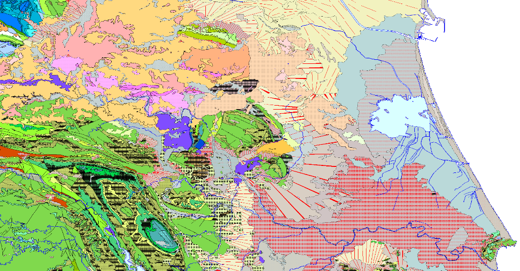
Servicio de visualización del mapa que representa el resultado de la homogeneización cartográfica de la serie del mapa geológico MAGNA (Cartografía geológica nacional a escala 1:50.000). Serie que integra 1143 mapas. Como consecuencia del dilatado proceso que ha supuesto la ejecución histórica de esta serie, se advierten diferencias entre sus fases iniciales y finales, en cuanto a criterios de asignación de unidades geológicas, nivel de detalle, continuidad de las unidades y estructuras geológicas en los bordes de hojas, codificación y simbologías. Con el objetivo de corregir estos problemas, en 2004 se inició el PLAN GEODE, que constituye el soporte institucional para la generación de un mapa geológico digital continuo a escala 1:50.000. El PLAN integra 19 Proyectos Regionales vinculados a sus correspondientes zonas geológicas. Sus objetivos fundamentales son tres: • Dotar de continuidad cartográfica a las hojas geológicas de la serie MAGNA dentro de cada región. • Generar una leyenda unificada de unidades geológicas para cada región. • Adecuar la cobertura geológica a una base topográfica uniforme, generada específicamente para el PLAN GEODE a partir del mapa topográfico nacional 1:25000 del IGN.
Visualisation Service (WMS) of the geological map which represents the result of the cartographic homogenisation of the MAGNA geological map series (National Geological Cartography at a scale of 1:50.000). Series that integrates 1143 maps. As a consequence of the long process involved in the historical execution of this series, there are differences between its initial and final phases, in terms of criteria for assigning geological units, level of detail, continuity of geological units and structures at the edges of sheets, coding and symbologies. With the aim of correcting these problems, the GEODE PLAN was initiated in 2004, which constitutes the institutional support for the generation of a continuous digital geological map at a scale of 1:50,000. The PLAN integrates 19 Regional Projects linked to their corresponding geological zones. Its fundamental objectives are threefold: - To provide cartographic continuity to the geological sheets of the MAGNA series within each region. - To generate a unified legend of geological units for each region. - To adapt the geological coverage to a uniform topographic base, generated specifically for the GEODE PLAN from the national topographic map 1:25000 of the IGN.
Simple
-
Date (Creation)Fecha (Creación)
- 2019-05-14
-
Date (Publication)Fecha (Publicación)
- 2019-05-14
- Point of contact
-
Organisation name Individual name Electronic mail address Role Instituto Geológico y Minero de España (IGME-CSIC)
Point of contactPunto de ContactoInstituto Geológico y Minero de España (IGME-CSIC)
CustodianGuardián
-
Tesauro IGME
IGME Thesaurus
-
-
Cartografía
Cartography
-
Geología
Geology
-
España
Spain
-
- Keywords
-
-
IGME
IGME
-
- Keywords
-
-
IDEE
IDEE
-
- Keywords
-
-
EGDI
EGDI
-
- Keywords
-
-
WMS
WMS
-
-
Especificaciones de Servicios Web
Web Services Specifications
-
-
OGC (Open Geospatial Consortium)
OGC (Open Geospatial Consortium)
-
WMS (Web Map Service)
WMS (Web Map Service)
-
WMS 1.3.0
WMS 1.3.0
-
OGC
OGC
-
WMS
WMS
-
-
ISO - 19119 geographic services taxonomy
ISO - 19119 geographic services taxonomy
-
-
infoMapAccessService
infoMapAccessService
-
-
INSPIRE_SpatialDataServicesClassification
INSPIRE_SpatialDataServicesClassification
-
-
Servicio de acceso a mapas
Map access service
-
Servicio de gestión de modelos/información geográficos
Geographic modelling/information management service
-
-
Access constraintsRestricciones de Acceso
-
Other restrictionsOtras restricciones
-
Otras limitacionesOther constraints
-
Sin limitaciones al acceso público.No limitations on public access
-
Use constraintsRestricciones de uso
-
Other restrictionsOtras restricciones
-
Otras limitacionesOther constraints
-
LICENCIA DE USO: Condiciones de uso público y difusión de la información para la reutilización de los datos IGME http://www.igme.es/Ayuda/CondiUso.htm
LICENCE OF USE: Conditions of public use and dissemination of information for the re-use of IGME data http://www.igme.es/Ayuda/CondiUso.htm
-
Service TypeTipo de Servicio
- view
))
-
Coupling TypeTipo de acoplamiento
-
TightApretado
- Contains Operations
-
Operation Name Distributed Computing Platforms Connect Point GetCapabilities
Web servicesServicios webhttp://mapas.igme.es/gis/services/Cartografia_Geologica/IGME_Geode_50/MapServer/WmsServer GetMap
Web servicesServicios webhttp://mapas.igme.es/gis/services/Cartografia_Geologica/IGME_Geode_50/MapServer/WmsServer GetFeatureInfo
Web servicesServicios webhttp://mapas.igme.es/gis/services/Cartografia_Geologica/IGME_Geode_50/MapServer/WmsServer
-
Operates OnOpera En
-
DateFecha
- Keywords
-
-
Identificador único del recurso
-
EPSG:4258 (ETRS89 coordenadas geográficas)
-
Identificador único del recurso
-
EPSG:23028 (ED50 / UTM zone 28Pico de las Nieves))
-
Identificador único del recurso
-
EPSG:23029 (ED50 / UTM zone 29N)
-
Identificador único del recurso
-
EPSG:23030 (ED50 / UTM zone 30N)
-
Identificador único del recurso
-
EPGS:23031 (ED50 / UTM zone 31N)
-
Identificador único del recurso
-
EPSG:3042 (ETRS89 TM 30N)
-
Identificador único del recurso
-
EPGS:4230
-
Distribution formatFormato de la distribución
-
- OnLine resource
-
Protocol Linkage Name OGC:WMS-1.3.0-http-get-capabilities
http://mapas.igme.es/gis/services/Cartografia_Geologica/IGME_Geode_50/MapServer/WmsServer?REQUEST=GetCapabilities&SERVICE=WMS Servicio de visualización (WMS) del Mapa Geológico Contínuo (GEODE) escala 1/50.000
Visualisation Service (WMS) of the Continuous Geological Map (GEODE) scale 1/50.000
-
Hierarchy levelJerarquía
-
ServiceServicio
- Other
-
Servicio web de datos espaciales. Servicio de visualización
Conformance result
Conformidad del Resultado
-
Date (Publication)Fecha (Publicación)
- 2009-10-19
-
Explicación
-
Consultar el reglamento
-
PassAprobado
- No
Conformance result
Conformidad del Resultado
-
Título
-
Reglamento (UE) n o 1089/2010 de la Comisión de 23 de noviembre de 2010 por el que se aplica la Directiva 2007/2/CE del Parlamento Europeo y del Consejo en lo que se refiere a la interoperabilidad de los conjuntos y los servicios de datos espaciales
-
Date (Publication)Fecha (Publicación)
- 2010-12-08
-
Explicación
-
Consultar el reglamento
-
PassAprobado
- No
Conformance result
Conformidad del Resultado
-
Título
-
REGLAMENTO (CE) No 1205/2008 DE LA COMISIÓN de 3 de diciembre de 2008 por el que se ejecuta la Directiva 2007/2/CE del Parlamento Europeo y del Consejo en lo que se refiere a los metadatos
-
Date (Publication)Fecha (Publicación)
- 2008-12-04
Citation identifier
Identificador del Contacto
-
Explicación
-
Consultar el reglamento
-
PassAprobado
- Yes
Metadata
-
File identifierIdentificador del fichero
- ESPIGMESERVICIOGEODE5020190513 XML
-
Metadata languageIdioma del metadato
- Spanish; Castilian
-
Character setCodificación
-
UTF8UTF8
-
Hierarchy levelJerarquía
-
ServiceServicio
- Hierarchy level name
-
Servicio
-
Date stampFecha
- 2025-05-09T05:37:30.183915Z
- Metadata standard name
-
Reglamento (CE) Nº 1205/2008 de Inspire, "Perfil IGME"
- Metadata standard version
-
2.0
- Metadata author
-
Organisation name Individual name Electronic mail address Role Instituto Geológico y Minero de España (IGME-CSIC)
Leticia Vega Martín
Leticia Vega Martín
Point of contactPunto de Contacto
- Other language
-
Language Character encoding EnglishEnglishUTF8UTF8Spanish; CastilianSpanish; CastilianUTF8UTF8
)))