 Catalogo de metadatos IGME-CSIC
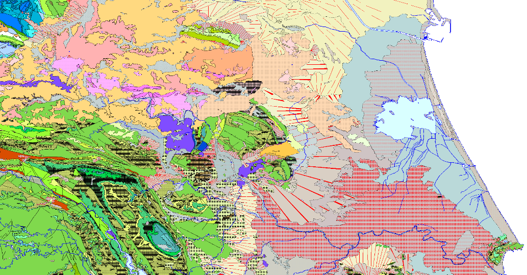
Continuous Geological Mapping Scale 1:50,000, GEODE
This map represents the result of the cartographic homogenisation of the MAGNA geological map series (National Geological Cartography at a scale of 1:50.000). Series that integrates 1143 maps. As a consequence of the long process involved in the historical execution of this series, there are differences between its initial and final phases, in terms of criteria for assigning geological units, level of detail, continuity of geological units and structures at the edges of sheets, coding and symbologies. With the aim of correcting these problems, the GEODE PLAN was initiated in 2004, which constitutes the institutional support for the generation of a continuous digital geological map at a scale of 1:50,000. The PLAN integrates 19 Regional Projects linked to their corresponding geological zones. Its fundamental objectives are threefold:
- To provide cartographic continuity to the geological sheets of the MAGNA series within each region.
- To generate a unified legend of geological units for each region.
- To adapt the geological coverage to a uniform topographic base, generated specifically for the GEODE PLAN from the national topographic map 1:25000 of the IGN.
Simple
- Alternate title
-
GEODE
- Date (Creation)
- 2005-12-01
- Date (Publication)
- 2007-12-31
- Citation identifier
- ESPIGMEGEODE50
- Presentation form
- Hardcopy map
- Presentation form
- Digital map
- Purpose
-
This cartopraphy is the result of the GEODE continuous geological mapping plan, it solves the problems of continuity in sheet edges of the previous MAGNA 50.000 series. It unifies criteria and offers a unique legend for each major region.
- Credit
-
The IGME is the institutional author of the series and its largest funder. The leaves are made by both IGME own staff and specialized service companies.
- Status
- Under development
- Point of contact
-
Organisation name Individual name Electronic mail address Role Geological Survey of Spain (IGME-CSIC) Alejandro Robador Moreno
Point of contact
- Maintenance and update frequency
- Irregular
- Spatial scope
-
IGME Thesaurus
-
-
Cartography
-
Geology
-
Spain
-
- Keywords
-
-
IGME
-
InventoryGM
-
- Keywords
-
-
IDEE
-
- Specific usage
-
Geological Cartography, Cartographic editing, Natural resources research, Planning, Geotechnics, Environment, etc.
- User contact info
-
Organisation name Individual name Electronic mail address Role Geological Survey of Spain (IGME-CSIC) Point of contact
- Use constraints
- Other restrictions
- Other constraints
-
LICENCE OF USE: Conditions of public use and dissemination of information for the re-use of IGME data. https://www.igme.es/condiciones-de-uso/
- Spatial representation type
- Vector
- Denominator
- 50000
- Language
- Spanish; Castilian
- Character set
- 8859 Part 1
- Topic category
-
- Geoscientific information
))
- Unique resource identifier
- EPSG:4258 (ETRS89 coordenadas geográficas)
- Unique resource identifier
- EPSG:23028 (ED50 / UTM zone 28Pico de las Nieves))
- Unique resource identifier
- EPSG:23029 (ED50 / UTM zone 29N)
- Unique resource identifier
- EPSG:23030 (ED50 / UTM zone 30N)
- Unique resource identifier
- EPGS:23031 (ED50 / UTM zone 31N)
- Unique resource identifier
- EPSG:3042 (ETRS89 TM 30N)
- Unique resource identifier
- EPGS:4230
- Distribution format
-
Name Version RASTER: JPG Con fichero de georeferenciación
Arcgis 9.2
VECTORIAL: SHAPE FILE (Uso restringido)
Arcgis 9.2
Web Map Service WMS
1.3.0
Distributor
- Distributor contact
-
Organisation name Individual name Electronic mail address Role Geological Survey of Spain (IGME-CSIC) Distributor
- Fees
-
Acceso a servicios de mapas desde INFOIGME: Portal de Cartografía Geocientífica Digital
- Fees
-
Distribución a través de la web
- Distributor format
-
Name Version Joint Photographic Group Format JPEG
Arcgis 9.2
Mapa digital: SHP - ArcView ShapeFile
Arcgis 9.2
Web Map Service WMS
1.3.0
Distributor
- Distributor contact
-
Organisation name Individual name Electronic mail address Role Geological Survey of Spain (IGME-CSIC) Distributor
- Distributor format
-
Name Version WMS - Web Map Service
1.3.0
- OnLine resource
-
Protocol Linkage Name https://mapas.igme.es/gis/services/Cartografia_Geologica/IGME_Geode_50/MapServer/WMSServer?REQUEST=GetCapabilities&SERVICE=WMS&VERSION=1.3.0 Servicio de visualización WMS del Mapa Geológico Continuo de España, GEODE a escala 1:50.000
WWW:LINK-1.0-http--related
https://info.igme.es/cartografiadigital/geologica/geode.aspx Information y consultation of the Geological Map of Spain, GEODE at scale 1:50.000
https://info.igme.es/visor/ Information from the Geological Map of Spain, GEODE at scale 1:50.000
http://info.igme.es/catalogo/ Search for the Geological Map of Spain, GEODE at scale 1:50.000
http://info.igme.es/cartografiadigital/datos/geode/docs/solicitud_informacion_GEODE.pdf Offline access to the Geological Map of Spain, GEODE at scale 1:50.000
- Hierarchy level
- Series
Conformance result
- Date (Publication)
- 2010-12-08
Citation identifier
- Explanation
-
See referenced specification
- Pass
- No
Conformance result
Conformance result
- Title
-
COMMISSION REGULATION (EC) No 1205/2008 of 3 December 2008 implementing Directive 2007/2/EC of the European Parliament and of the Council as regards metadata
- Date (Publication)
- 2008-12-04
- Explanation
-
See referenced specification
- Pass
- Yes
- Statement
-
This Continuous Cartography was produced WITHIN THE GEODE PLAN from the pre-existing MAGNA E.1:50.000 series, improved with more recent geological cartographies produced by the IGME and other institutions, under the technical supervision of the IGME.
- Description
-
Generation of original dataset
- Date / Time
- 2008-06-01T12:00:00
- Description
-
Uniform data set processing
- Description
-
Integration in BDD
- Description
-
Publication on the internet
- Description
-
This continuous cartography was prepared within the GEODE plan from the pre-existing MAGNA E.1:50.000 series, improved with more recent geological cartographies made by the IGME and by other institutions, such as the Universities of Oviedo and Salamanca, coming, in the latter case, from licentiate and doctoral theses and other research works, both published and unpublished. This cartographic work has been carried out by Luis González Menéndez and Nemesio Heredia Carballo of the IGME, with the main collaboration of Alberto Marcos Vallaure of the University of Oviedo, under the technical supervision of the IGME.
- Denominator
- 50000
- Title
-
Geological Map of Spain at scale 1:50.000 MAGNA (IGME)
- Alternate title
-
MAGNA
- Date (Creation)
- 1972-01-01
Citation identifier
- Cited responsible party
-
Organisation name Individual name Electronic mail address Role Geological Survey of Spain (IGME-CSIC) Robador Moreno, Alejandro
Originator Geological Survey of Spain (IGME-CSIC) Alejandro Robador Moreno
Distributor
- Presentation form
- Hardcopy document
- Presentation form
- Hardcopy map
Metadata
- File identifier
- ESPIGMEGEODE20220520 XML
- Metadata language
- Spanish; Castilian
- Character set
- UTF8
- Hierarchy level
- Series
- Hierarchy level name
-
Cartografía Geológica Contínua Escala 1:50.000, GEODE
- Date stamp
- 2026-03-11T08:34:21.900404Z
- Metadata standard name
-
Reglamento (CE) Nº 1205/2008 de Inspire, "Perfil IGME"
- Metadata standard version
-
TG 2.0
- Metadata author
-
Organisation name Individual name Electronic mail address Role Geological Survey of Spain (IGME-CSIC) Leticia Vega Martín
Point of contact
- Other language
-
Language Character encoding English Spanish; Castilian UTF8
)))