 Catalogo de metadatos IGME-CSIC
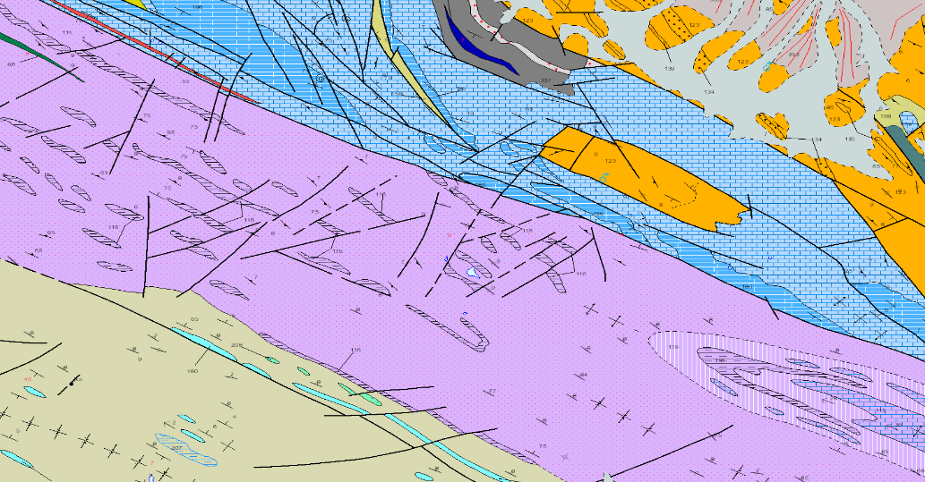
CARTOGRAFÍA GEOLÓGICA CONTINUA, ZONA 1500 OSSA-MORENA
CONTINUOUS GEOLOGICAL MAPPING, ZONE 1500 OSSA-MORENA AREA
LA CARTOGRAFIA GEOLOGICA es la representación de los materiales de la superficie en base a sus características litológicas, estratigráficas, estructurales, de antigüedad, etc. Se compone de los siguiente niveles de información: Z1500MRGEO: Unidades cartográficas, recintos geológicos diferenciados; Z1500MPGEO: Etiquetas de los recintos geológicos; Z1500MLGEO: Líneas auxiliares de anclaje de las etiquetas de los polígonos geológicos ; Z1500MLCON: Líneas de contactos y fallas. Entidades lineales de origen diverso; Z1500MPBUZ: Puntos y etiquetas de entidades puntuales y medidas estructurales.
GEOLOGICAL CARTOGRAPHY is the representation of surface materials on the basis of their lithological, stratigraphic, structural, age, etc. characteristics. It is composed of the following levels of information: Z1500MRGEO: Cartographic units, differentiated geological enclosures; Z1500MPGEO: Geological enclosure labels; Z1500MLGEO: Auxiliary anchor lines of the geological polygon labels; Z1500MLCON: Contact and fault lines. Linear entities of diverse origin; Z1500MPBUZ: Points and labels of point entities and structural measures.
Simple
-
Título alternativoAlternate title
-
MAPA GEOLÓGICO CONTINUO DE LA ZONA DE OSSA-MORENA
CONTINUOUS GEOLOGICAL MAP OF THE OSSA-MORENA AREA
-
Date (Creation)Fecha (Creación)
- 2009-04-30
-
Date (Publication)Fecha (Publicación)
- 2009-10-08
-
Edition dateFecha de edición
- 2009-01-01
-
Citation identifierIdentificador del Contacto
-
ESPIGMEGEODE50Z1500
Identificación del Instituto Geológico y Minero de España. Centro de DocumentaciónIdentification of the Geological Survey of Spain. Documentation Centre2009-01-01
-
Presentation formFormulario de presentación
-
Hardcopy mapMapa en papel
-
Presentation formFormulario de presentación
-
Digital mapMapa digital
-
PropósitoPurpose
-
Esta CARTOGRAFIA es el resultado del Plan de cartografía geológica continua GEODE, soluciona los problemas de continuidad en bordes de hoja de la serie precedente MAGNA 50.000. Unifica criterios y ofrece una leyenda única para cada gran región geológica (Zona). En este caso la región coincide con una de las zonas en que está dividido el Macizo Ibérico del Orógeno Varisco, denominada Zona de Ossa-Morena.
This CARTOGRAPHY is the result of the GEODE continuous geological mapping plan, it solves the problems of continuity in sheet edges of the previous MAGNA 50.000 series. It unifies criteria and offers a unique legend for each large geological region (Zone). In this case, the region coincides with one of the zones into which the Iberian Massif of the Variscan Orogen is divided, called the Ossa-Morena Zone.
-
CréditoCredit
-
Martín Parra. L.M; Matas González, J; Sánchez , T; Eguiluz, L.
lMartín Parra. L.M; Matas González, J; Sánchez , T; Eguiluz, L.
-
StatusEstado
-
en desarrolloen desarrollo
- Point of contact
-
Organisation name Individual name Electronic mail address Role Instituto Geológico y Minero de España (IGME-CSIC)
Luis Miguel Martín Parra,
Principal investigatorInvestigador principaInstituto Geológico y Minero de España (IGME-CSIC)
Jerónimo Matas González
Jerónimo Matas González
OriginatorOrígenFacultad de Geología, Universidad de Oviedo
Teresa Sánchez
Teresa Sánchez
OriginatorOrígenUniversidad del Pais Vasco
Luis Eguiluz
Luis Eguiluz
OriginatorOrígenSIMNA
Carlos Velando
Carlos Velando
ProcessorProcesoSIMNA
Arturo Carvajal
Arturo Carvajal
ProcessorProcesoInstituto Geológico y Minero de España (IGME-CSIC)
Margarita Sanabria Pavón
Margarita Sanabria Pavón
ProcessorProcesoInstituto Geológico y Minero de España (IGME-CSIC)
Javier Navas Madrazo
Javier Navas Madrazo
ProcessorProcesoInstituto Geológico y Minero de España (IGME-CSIC)
DistributorDistribuidor
-
Maintenance and update frequencyMantenimiento y frecuencia de actualización
-
data is updated as deemed necessarydata is updated as deemed necessary
-
Nota de mantenimientMaintenance note
-
La actualización de los datos se realiza a instancias del responsable del IGME asignado para esta zona. En función de la magnitud de las modificaciones existen diferentes protocolos de edición para la alteración de los datos actuales.
The updating of the data is carried out at the request of the person in charge of the IGME assigned to this area. Depending on the magnitude of the modifications, there are different editing protocols for the alteration of the current data.
-
Tesauro IGME
IGME Thesaurus
-
-
Mapa geológico
Geological map
-
Falla
Fault
-
Buzamiento
Dip
-
Contacto
Boundary
-
Eje pliegue
Fold axis
-
Leyenda
Legend
-
Ossa Morena
Ossa Morena
-
Geología
Geology
-
Estratigrafía
Stratigraphy
-
Minería
Mining
-
Cronoestratigrafía
Chronostratigraphy
-
-
DisciplineDisciplina
-
-
Geología
Geology
-
Estratigrafía
Stratigraphy
-
Minería
Mining
-
Cronoestratigrafía
Chronostratigraphy
-
- Keywords
-
- Keywords
-
-
Uso específicoSpecific usage
-
Cartografia Geológica, Edición cartográfica, Investigación de recursos naturales, Planificacion, Geotecnia, Medioambiente, etc
Geological Cartography, Cartographic editing, Natural resources research, Planning, Geotechnics, Environment, etc.
- User contact info
-
Organisation name Individual name Electronic mail address Role Instituto Geológico y Minero de España (IGME-CSIC)
Point of contactPunto de Contacto
-
Access constraintsRestricciones de Acceso
-
Other restrictionsOtras restricciones
-
Otras limitacionesOther constraints
-
Sin limitaciones al acceso público.No limitations on public access.
-
Use constraintsRestricciones de uso
-
Other restrictionsOtras restricciones
-
Otras limitacionesOther constraints
-
LICENCIA DE USO: Condiciones de uso público y difusión de la información para la reutilización de los datos IGME http://www.igme.es/Ayuda/CondiUso.htm
LICENCE OF USE: Conditions of public use and dissemination of information for the re-use of IGME data. http://www.igme.es/Ayuda/CondiUso.htm
-
Spatial representation typeTipo de representación espacial
-
VectorVector
-
DenominatorDenominador
- 50000
-
LanguageIdioma
- Spanish; Castilian
-
Character setCodificación
-
UTF8UTF8
-
Topic categoryCategoría temática
-
-
Geoscientific informationInformación geocientífica
-
-
DescripciónDescription
-
España
Spain
))
-
Extent type codeCódigo del tipo de extensión
- Yes
-
Geographic identifierIdentificador geográfico
-
ES
-
Identificador único del recurso
-
EPSG:4258 (ETRS89 coordenadas geográficas)
-
Identificador único del recurso
-
EPSG:23028 (ED50 / UTM zone 28Pico de las Nieves))
-
Identificador único del recurso
-
EPSG:23029 (ED50 / UTM zone 29N)
-
Identificador único del recurso
-
EPSG:23030 (ED50 / UTM zone 30N)
-
Identificador único del recurso
-
EPGS:23031 (ED50 / UTM zone 31N)
-
Identificador único del recurso
-
EPSG:3042 (ETRS89 TM 30N)
-
Identificador único del recurso
-
EPGS:4230
- Distribution format
-
Name Version RASTER: JPG Con fichero de georeferenciación
Arcgis 9.2
VECTORIAL: SHAPE FILE (Uso restringido)
Arcgis 9.2
Web Map Service WMS
1.3.0
Distributor
Distribuidor
- Distributor contact
-
Organisation name Individual name Electronic mail address Role Instituto Geológico y Minero de España (IGME-CSIC)
DistributorDistribuidor
- Fees
-
Acceso a servicios de mapas desde INFOIGME: Portal de Cartografía Geocientífica Digital
- Fees
-
Distribución a través de la web gratuita
- Distributor format
-
Name Version Joint Photographic Group Format JPEG
Arcgis 9.2
Mapa digital: SHP - ArcView ShapeFile
Arcgis 9.2
Web Map Service WMS
1.3.0
Distributor
Distribuidor
- Distributor contact
-
Organisation name Individual name Electronic mail address Role Vicedirección Técnica de Sistemas de Información Geológica del Instituto Geológico y Minero del España (IGME-CSIC)
DistributorDistribuidor
- Distributor format
-
Name Version Servicio web: WMS - Web Map Service
1.3.0
- OnLine resource
-
Protocol Linkage Name OGC Web Map Service http://mapas.igme.es/gis/services/Cartografia_Geologica/IGME_Geode_50/MapServer/WMSServer?REQUEST=getcapabilities&SERVICE=WMS&VERSION=1.3.0 Servicio de visualización WMS del Mapa Geológico Contínuo de España, GEODE a escala 1:50.000
WMS visualisation service of the Continuous Geological Map of Spain, GEODE at scale 1:50.000
WWW:LINK-1.0-http--related
http://info.igme.es/cartografiadigital/geologica/geodezona.aspx?Id=Z1500&language=es Información y consulta del Mapa Geológico de España, GEODE ZONA 1500 (OSSA-MORENA) a escala 1:50.000
Information and consultation the Geological Map of Spain, GEODE ZONE 1500 (OSSA-MORENA) at scale 1:50.000
https://info.igme.es/visor/ Información del Mapa Geológico de España, GEODE ZONA 1500 (OSSA-MORENA) a escala 1:50.000
Information from the Geological Map of Spain, GEODE ZONE 1500 (OSSA-MORENA) at scale 1:50.000
http://info.igme.es/catalogo/ Búsqueda del Mapa Geológico de España, GEODE ZONA 1500 (OSSA-MORENA) a escala 1:50.000
Search for the Geological Map of Spain, GEODE ZONE 1500 (OSSA-MORENA) at scale 1:50.000
http://info.igme.es/cartografiadigital/datos/geode/docs/solicitud_informacion_GEODE.pdf Acceso fuera de línea del Mapa Geológico de España, GEODE ZONA 1500 (OSSA-MORENA) a escala 1:50.000
Offline access to the Geological Map of Spain, GEODE ZONE 1500 (OSSA-MORENA) at scale 1:50.000
-
Hierarchy levelJerarquía
-
DatasetConjunto de datos
Conformance result
Conformidad del Resultado
-
Date (Publication)Fecha (Publicación)
- 2014-12-31
-
Explicación
-
Los datos no son conformes
-
PassAprobado
- No
Conformance result
Conformidad del Resultado
-
DeclaraciónStatement
-
Esta Cartografía continua se confeccionó DENTRO DEL PLAN GEODE a partir de la serie preexistente MAGNA E.1:50.000, mejorada con cartografías geológicas más recientes realizadas por el IGME para su publicación a escala 1:200.000 (Hojas 1:200.000 de Pozoblanco y Córdoba) o para revisiones del MAGNA (1:50.000 nº 919, 920, 921, 922, 923, 940, 941 y 942). Esta labor ha sido efectuada por Jerónimo Matas y Luis Miguel Martín Parra, en Convenio con la Junta de Andalucía, y a partir de la documentación previamente citada y de una síntesis previa de la Provincia de Badajoz realizada en Convenio con la Junta de Extremadura por Luis Eguíluz (Universidad del Pais Vasco) y Octavio Apalategui (Profesional Libre), así como de una síntesis del Macizo Ibérico en la Hoja 1:200.000 de Córdoba realizada por Teresa Sánchez (IGME) , con la colaboración en la Síntesis Digital de Carlos Velando (SIMNA) y Arturo Carvajal (SIMNA), realizándose bajo la supervisión técnica del IGME.
This continuous Cartography was made WITHIN THE GEODE PLAN from the pre-existing MAGNA E.1:50.000 series, improved with more recent geological cartographies made by the IGME for publication at a scale of 1:200.000 (1:200.000 sheets of Pozoblanco and Córdoba) or for revisions of the MAGNA (1:50.000 no. 919, 920, 921, 922, 923, 940, 941 and 942). This work has been carried out by Jerónimo Matas and Luis Miguel Martín Parra, in agreement with the Junta de Andalucía, and from the previously mentioned documentation and a previous synthesis of the Province of Badajoz carried out in agreement with the Junta de Extremadura by Luis Eguíluz (University of the Basque Country) and Octavio Apalategui (Free Professional), as well as a synthesis of the Iberian Massif on Sheet 1:200. 000 of Córdoba by Teresa Sánchez (IGME), with the collaboration in the Digital Synthesis of Carlos Velando (SIMNA) and Arturo Carvajal (SIMNA), carried out under the technical supervision of the IGME.
-
DescripciónDescription
-
Generación del conjunto original de datos
Generation of original dataset
-
Date / TimeFecha/Hora
- 2009-04-30T12:00:00
-
DescripciónDescription
-
Procesado uniforme del conjunto de datos
Uniform data set processing
-
Date / TimeFecha/Hora
- 2009-10-08T12:00:00
-
DescripciónDescription
-
Integracion en BDD
Integration in BDD
-
DescripciónDescription
-
Publicacion en internet
Publication on the internet
-
DescripciónDescription
-
Esta Cartografía continua se confeccionó dentro del Plan GEODE a partir de la serie preexistente MAGNA E.1:50.000, mejorada con cartografías geológicas más recientes realizadas por el IGME para su publicación a escala 1:200.000 (Hojas 1:200.000 de Pozoblanco y Córdoba) o para revisiones del MAGNA (1:50.000 nº 919, 920, 921, 922, 923, 940, 941 y 942). Esta labor ha sido efectuada por Jerónimo Matas y Luis Miguel Martín Parra, en Convenio con la Junta de Andalucía, y a partir de la documentación previamente citada y de una síntesis previa de la Provincia de Badajoz realizada en Convenio con la Junta de Extremadura por Luis Eguíluz (Universidad del Pais Vasco) y Octavio Apalategui (Profesional Libre), así como de una síntesis del Macizo Ibérico en la Hoja 1:200.000 de Córdoba realizada por Teresa Sánchez (IGME) , con la colaboración en la Síntesis Digital de Carlos Velando (SIMNA) y Arturo Carvajal (SIMNA), realizándose bajo la supervisión técnica del IGME.
This continuous cartography was produced within the GEODE Plan from the pre-existing MAGNA E.1:50.000 series, improved with more recent geological cartographies made by the IGME for publication at a scale of 1:200.000 (1:200.000 sheets of Pozoblanco and Córdoba) or for revisions of the MAGNA (1:50.000 no. 919, 920, 921, 922, 923, 940, 941 and 942). This work has been carried out by Jerónimo Matas and Luis Miguel Martín Parra, in agreement with the Junta de Andalucía, and from the previously mentioned documentation and a previous synthesis of the Province of Badajoz carried out in agreement with the Junta de Extremadura by Luis Eguíluz (University of the Basque Country) and Octavio Apalategui (Free Professional), as well as a synthesis of the Iberian Massif on Sheet 1:200. 000 of Córdoba by Teresa Sánchez (IGME), with the collaboration in the Digital Synthesis of Carlos Velando (SIMNA) and Arturo Carvajal (SIMNA), carried out under the technical supervision of the IGME.
-
DenominatorDenominador
- 50000
-
TítuloTitle
-
Mapa Geológico de España a escala 1:50.000 MAGNA (IGME)
Geological Map of Spain at scale 1:50.000 MAGNA (IGME)
-
Título alternativoAlternate title
-
MAGNA
MAGNA
-
Date (Creation)Fecha (Creación)
- 1972-01-01
Citation identifier
Identificador del Contacto
- Cited responsible party
-
Organisation name Individual name Electronic mail address Role Instituto Geológico y Minero de España (IGME-CSIC)
Robador Moreno, Alejandro
Robador Moreno, Alejandro
OriginatorOrígen
-
Presentation formFormulario de presentación
-
Hardcopy documentDocumento en papel
-
Presentation formFormulario de presentación
-
Hardcopy mapMapa en papel
Metadata
-
File identifierIdentificador del fichero
- ESPIGMEGEODE50Z150020190302 XML
-
Metadata languageIdioma del metadato
- Spanish; Castilian
-
Character setCodificación
-
UTF8UTF8
- Parent identifier
-
Cartografía Geológica Continua Escala 1:50.000, GEODE
ESPIGMEGEODE20220520
-
Hierarchy levelJerarquía
-
DatasetConjunto de datos
-
Date stampFecha
- 2025-05-09T07:17:33.385124Z
- Metadata standard name
-
Reglamento (CE) Nº 1205/2008 de Inspire, "Perfil IGME"
- Metadata standard version
-
TG 2.0
- Metadata author
-
Organisation name Individual name Electronic mail address Role Instituto Geológico y Minero de España (IGME-CSIC)
Leticia Vega Martín
Leticia Vega Martín
Point of contactPunto de Contacto
- Other language
-
Language Character encoding EnglishEnglishUTF8UTF8Spanish; CastilianSpanish; CastilianUTF8UTF8
)))