 Catalogo de metadatos del IGME
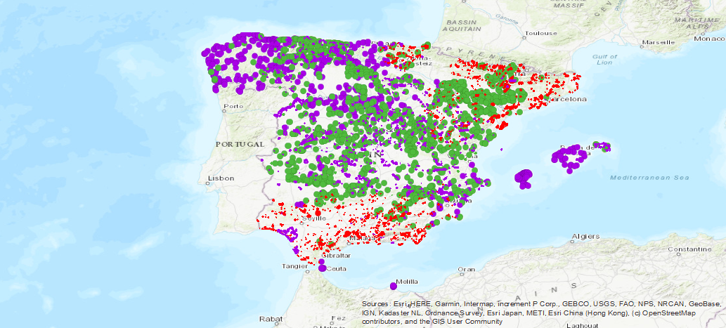
Spain
Type of resources
Available actions
Topics
Provided by
Years
Formats
Representation types
Update frequencies
status
Service types
Scale
-
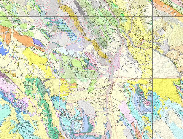
The National Geological Map (MAGNA), was made between 1972 and 2003 by the Geological Survey of Spain. It is distributed in sheets 1: 50.000 (1: 25.000 in particular cases of the Canary Islands, Ibiza-Formentera, Menorca, Ceuta and Melilla). The geological map shows the nature of materials (rocks and sediments) that appear on the surface, their spatial distribution and geometric relationships between the different cartographic units represented. A geological mapping unit is the grouping of one or more lithologies with common age range, which is represented on the map at a scale or defined resolution. Each mapping unit, and the different geological structures, is represented on the map with a symbolism itself. The representation of these units on the topographic base map provides some three-dimensional information that is completed with other geological data and geological sections, stratigraphic profiles, polls, etc. The map legend is a pictogram representing the spatial relationship of the different mapping units (chronology, overlapping, geometric relationship, lateral facies changes, etc.). It also includes structural, hydrogeological and geological location of the sheet within the regional schemes. Since 1991, the Geological Map Series MAGNA is made inseparably with the geomorphological map on the same scale. This map incorporates everything on the surface geology and provides a structured and accurate information of the land forms. It is organized on the basis of morphogenesis and morphocronology incorporated the map using the corresponding chronostratigraphic column included in a table / legend inspired by the geological map. The forms, erosional and depositional, are represented on the map by individualized by symbols and patterns of color and surface deposits or lithological formations elements that provide information. For each sheet of the series MAGNA there is an explanatory report published, edited and in digital format. The digital information is stored in coverage and Shape format (ESRI). There is a guide that describes the physical structure of the digital information and its codification.
-
This map represents the result of the cartographic homogenisation of the MAGNA geological map series (National Geological Cartography at a scale of 1:50.000). Series that integrates 1143 maps. As a consequence of the long process involved in the historical execution of this series, there are differences between its initial and final phases, in terms of criteria for assigning geological units, level of detail, continuity of geological units and structures at the edges of sheets, coding and symbologies. With the aim of correcting these problems, the GEODE PLAN was initiated in 2004, which constitutes the institutional support for the generation of a continuous digital geological map at a scale of 1:50,000. The PLAN integrates 19 Regional Projects linked to their corresponding geological zones. Its fundamental objectives are threefold: - To provide cartographic continuity to the geological sheets of the MAGNA series within each region. - To generate a unified legend of geological units for each region. - To adapt the geological coverage to a uniform topographic base, generated specifically for the GEODE PLAN from the national topographic map 1:25000 of the IGN.
-

The National Geological Map (MAGNA), was made between 1972 and 2003 by the Geological Survey of Spain. It is distributed in sheets 1: 50.000 (1: 25.000 in particular cases of the Canary Islands, Ibiza-Formentera, Menorca, Ceuta and Melilla). The geological map shows the nature of materials (rocks and sediments) that appear on the surface, their spatial distribution and geometric relationships between the different cartographic units represented.
-
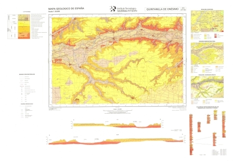
The sheet 373 (QUINTANILLA DE ONESIMO) of the National Geological Map (MAGNA), was made in 1997 and published in 2008 by the Geological Survey of Spain. It is distributed at scale 50000. The geological map shows the nature of materials (rocks and sediments) that appear on the surface, their spatial distribution and geometric relationships between the different cartographic units represented. A geological mapping unit is the grouping of one or more lithologies with common age range, which is represented on the map at a scale or defined resolution. Each mapping unit, and the different geological structures, is represented on the map with a symbolism itself. The representation of these units on the topographic base map provides some three-dimensional information that is completed with other geological data and geological sections, stratigraphic profiles, polls, etc. The map legend is a pictogram representing the spatial relationship of the different mapping units (chronology, overlapping, geometric relationship, lateral facies changes, etc.). It also includes structural, hydrogeological and geological location of the sheet within the regional schemes. Since 1991, the Geological Map Series MAGNA is made inseparably with the geomorphological map on the same scale. This map incorporates everything on the surface geology and provides a structured and accurate information of the land forms. It is organized on the basis of morphogenesis and morphocronology incorporated the map using the corresponding chronostratigraphic column included in a table / legend inspired by the geological map. The forms, erosional and depositional, are represented on the map by individualized by symbols and patterns of color and surface deposits or lithological formations elements that provide information. For each sheet of the series MAGNA there is an explanatory report published, edited and in digital format. The digital information is stored in coverage and Shape format (ESRI). There is a guide that describes the physical structure of the digital information and its codification.
-
Iso-content maps of Selenium (Se), one of the chemical elements.obtained in the Geochemical Atlas of Spain Project, distributed in stream sediments (14,864 samples), superficial soils (0-20 cm.) (13,505 samples) and deeper soils (20-40 cm.) (7,682 samples). The results of the chemical analysis are shown in two types: total dissolution of the sample with 4 acids and partial dissolution with aqua regia. With the analytical results of all the sampled points, an isocontent map is made with adjustment to a square grid of 1,000 m by the method of interpolation of the inverse of the squared distance. The final result is a map for each type of sample and type of analysis carried out.
-
Web service for the discovery of spatial data sets and services based on the INSPIRE Catalogue profile (CSW ISO AP) that allows consultation of the metadata records of the NC Instituto Geológico y Minero de España (IGME)-CSIC.
-
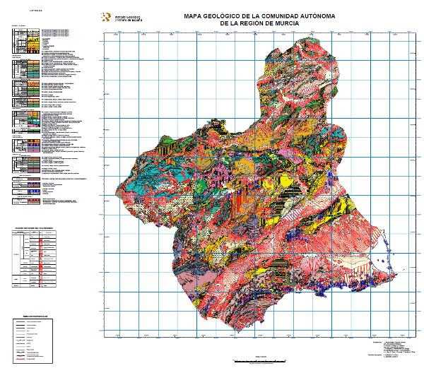
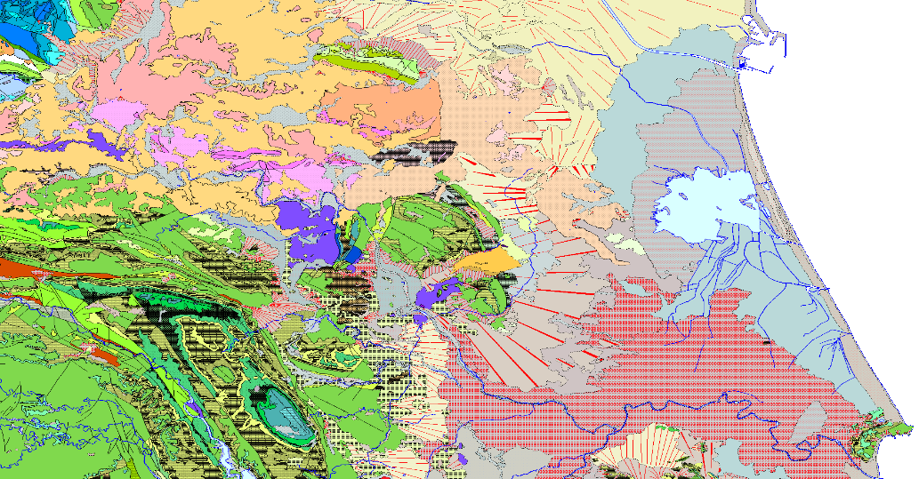
Map showing the chronolithostratigraphic units of the Region of Murcia grouped by the different structural domains present in the region, accompanied by the tectonic structure expressed by faults and traces of folding structures. On the Neogene and Quaternary units, the different facies present in each of them have been differentiated, reflecting the sedimentation domain and system, the geomorphological unit and the lithology.
-
Historical data of the surveys carried out for the investigation of the different aquifers of Spain, the result of the collaboration between the Geological and Mining Institute of Spain (IGME), with the National Institute of Agrarian Reform and Development (IRYDA), before the National Institute of Colonization (INC). The surveys were conducted mainly between 1950 and 1990
-
Spanish national inventory of land movements. Includes land movements of gravitational geological origin affecting Spanish territory, such as landslide movements: landslides, landslides, flows, etc., vertical movements: subsidies, collapses, expansiveness and underwater landslides. It does not include movements of tectonic origin such as those produced by earthquakes or continental drift or of volcanic origin. BD-MOVES is structured in two blocks or sets of georeferenced spatial information: the one referring to the description of the intrinsic and relatively invariable characteristics of the movement of the terrain and the one referring to the different activity events that produced these movements, including morphometry, triggering factors and damages, among other data.
-
Database of the Spanish Inventory of Places of Geological Interest (IELIG) which, in accordance with Law 42/2007, must be drawn up and updated by the Ministry of Agriculture, Food and the Environment, with the collaboration of the Autonomous Communities and scientific institutions. Royal Decree 1274/2011, entrusts the IGME with the completion of this inventory, without prejudice to the actions that the Autonomous Communities, in the use of their powers, carry out to complete it in their respective territories. Includes LIGs from the former IGME national inventory (developed basically between 1978 and 1988) and MAGNA geological mapping projects, plus sites that come from the IGME inventory carried out with the methodology designed for the IELIG but which have not been collected by the official autonomous inventories.