 Catalogo de metadatos del IGME
SPAIN
Type of resources
Available actions
Topics
Provided by
Years
Formats
Representation types
Update frequencies
status
Service types
Scale
-
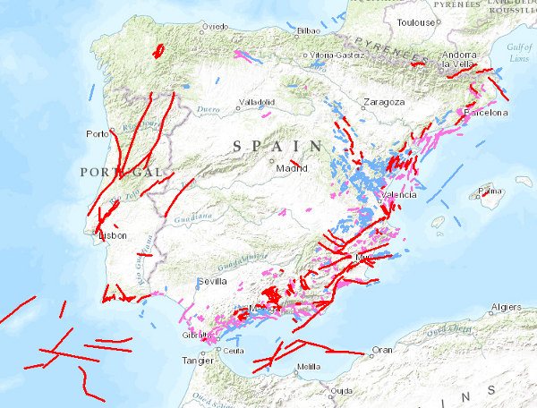
Visualisation service of QAFI, a database of faults with geological evidence of proven activity during the Quaternary period (the last 2.6 million years according to the limit officially established by the SQS in 2009) of the Iberian Peninsula. It is a project in constant revision and updating as a result of the progress of studies and knowledge about the structures capable of generating earthquakes in Iberia, and can never be considered complete or definitive, both because of the scientific nature of the data contained in it, and because of the modus operandi used in its construction: the altruistic collaboration of numerous researchers in Earth Sciences.
-
QAFI is a database of faults with geological evidence of proven activity during the Quaternary period (the last 2.6 million years according to the limit officially established by the SQS in 2009) of the Iberian Peninsula. It is a project in constant revision and updating as a result of the progress of studies and knowledge about the structures capable of generating earthquakes in Iberia, and can never be considered complete or definitive, both because of the scientific nature of the data contained in it, and because of the modus operandi used in its construction: the altruistic collaboration of numerous researchers in Earth Sciences. QAFI, both in Access format and geospatially represented, is hosted and maintained by the Geological Survey of Spain (IGME), and is accessible to the entire scientific and technical community and society in general.
-
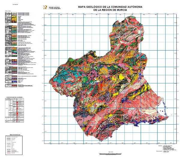
Mapa con las unidades cronolitoestratigráficas de la Región de Murcia agrupadas por los diferentes dominios estructurales presentes en la región, acompañadas la estructura tectónica expresada mediante fallas y traza de estructuras de plegamiento. Sobre las unidades del Neógeno y del Cuaternario se han diferenciado las distintas facies presentes en cada una de ellas, reflejándose el dominio y sistema de sedimentación, la unidad geomorfológica y la litología.
-

Mapa con las unidades cronolitoestratigráficas de la provincia de Alicante acompañado de fallas y estructuras de plegamiento. Forma parte de una síntesis geológica unificada de la Comunidad Valenciana.
-
Database of sterile deposits from mining washers. It also contains alphanumeric information of the different registers, documentary information (photographs, sketches and situation maps). This information is of national scope and has been generated thanks to the agreement "Update of the National Inventory of Mining Sterile Bodies" signed by the IGME and the General Directorate of Mines (MINER) in 1999. Information contained in the "Inventory" has also been used. in the "National Inventory of Mine Waste Ponds and Mining Tailings" carried out by the IGME between 1983 and 1989. It is a georeferenced documentary database managed with SQL Server, available online at http://info.igme.es/balsas
-
El mapa de geológico por edades de las unidades a escala 1:1.000.000 se ha generado a partir de la información de la columna cronolitoestratigráfica del mapa. En todas las unidades se ha especificado el Sistema, la Serie solo se ha cubierto en la mitad aproximadamente y el Piso es ocasional. En los casos en los que no se ha podido establecer un tramo cornoestratigráfico se ha optado por asignar el valor "sin determinar".
-
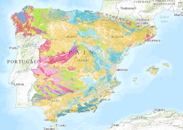
El mapa litológico a escala 1:1.000.000 se ha obtenido asignando a cada unidad cartográfica del mapa la litología o asociación litológica más representativa. Se ha partido de la clasificación original del mapa editado, que ha sido revisada posteriormente dando lugar a la clasificación actual.
-
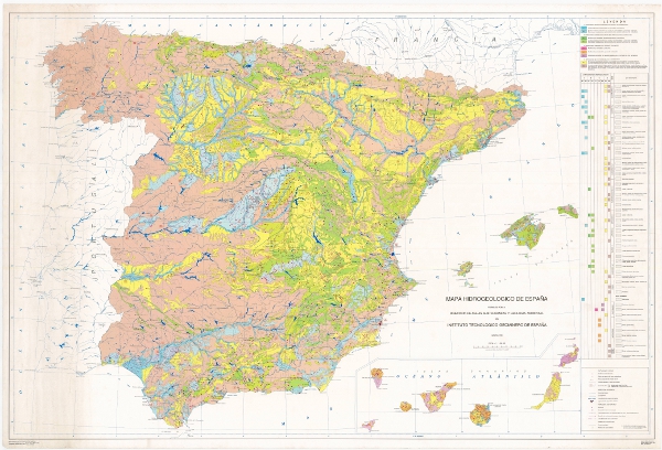
Mapa Hidrogeológico de España clasificado según el tipo de acuífero y la caracterización litogeoquímica.
-
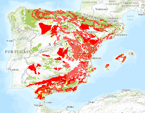
Mapa en el que se delimitan las zonas con diferentes tipos de movimientos del terreno, representando los movimientos más intensos y frecuentes. Señala, por lo tanto, la distribución y extensión de las zonas más problemáticas desde un punto de vista práctico. Los movimientos del terreno se clasifican en cuatro grandes grupos: movimientos de componente horizontal (deslizamientos y desprendimientos), movimientos de componente vertical (hundimientos y subsidencias, y expansividad de arcillas), procesos inestables en zonas litorales y movimientos relacionados con explotaciones mineras. También se incluyen las áreas con procesos erosivos importantes. Este mapa, publicado en el año 1987, ha sido elaborado íntegramente por personal del Instituto Geológico y Minero de España como respuesta a las necesidades de información relativas a los peligros y riesgos geológicos a escala nacional.
-
Mapa con las unidades cronolitoestratigrá¡ficas de la zona cubierta por la hoja separadas por distintos tipos de contactos: normal o concordante, discordante, intrusivo y de otra índole. La estructura tectónica se representa mediante las trazas cartográficas de los pliegues, la orientación y buzamiento de los elementos planares y lineares contenidos en las rocas, así como por la relación estructural -mediante fallas y cabalgamientos- entre los conjuntos rocosos diferenciados cartográficamente. También se representan características singulares de las rocas ígneas así como el grado de migmatización de las rocas metamórficas. El mapa está acompañado de la leyenda litoestratigráfica y los signos convencionales.