 Catalogo de metadatos del IGME
Dip
Type of resources
Available actions
Topics
Provided by
Representation types
Update frequencies
status
Scale
-
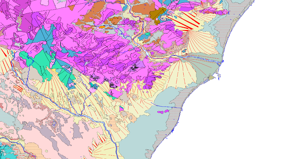
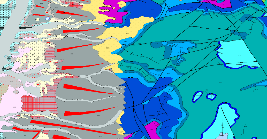
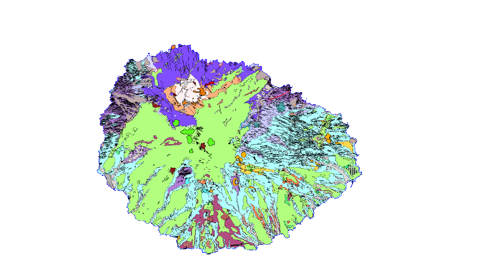
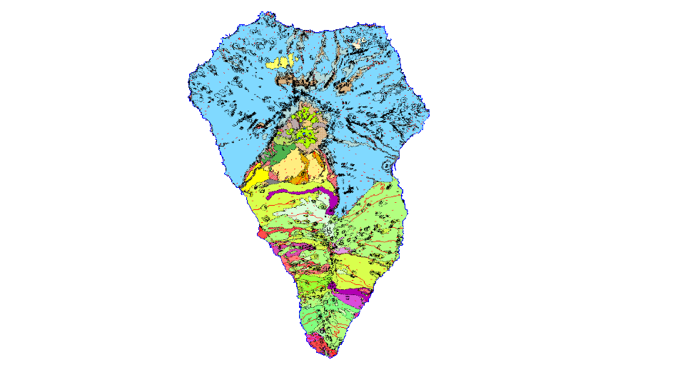
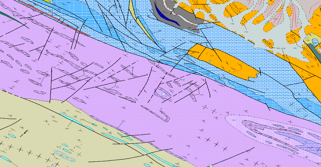
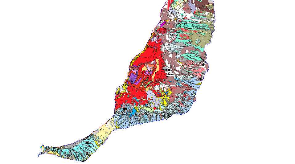
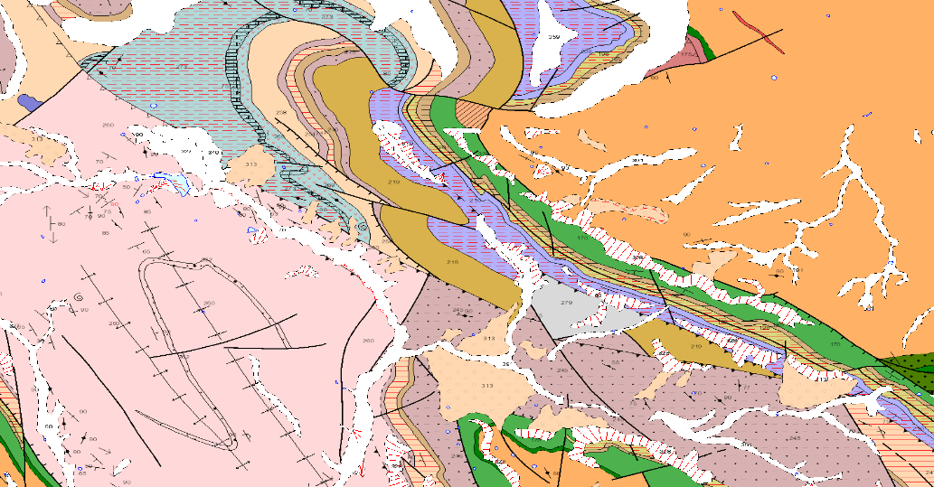
GEOLOGICAL CARTOGRAPHY is the representation of surface materials on the basis of their lithological, stratigraphic, structural, age, etc. characteristics. It is composed of the following levels of information: Z2800MRGEO: Cartographic units, differentiated geological enclosures; Z2800MPGEO: Geological enclosure labels; Z2800MLGEO: Auxiliary anchor lines of the geological polygon labels; Z2800MLCON: Contact and fault lines. Linear entities of diverse origin; Z2800MPBUZ: Points and labels of point entities and structural measures.
-
GEOLOGICAL CARTOGRAPHY is the representation of surface materials on the basis of their lithological, stratigraphic, structural, age, etc. characteristics. It is composed of the following levels of information: Z1100MRGEO: Cartographic units, differentiated geological enclosures; Z1100MPGEO: Geological enclosure labels; Z11006MLGEO: Auxiliary anchor lines of geological polygon labels; Z1100MLCON: Contact and fault lines. Linear entities of diverse origin; Z1100MPBUZ: Points and labels of point entities and structural measures; Z1100MLCON: Contact lines and faults.
-
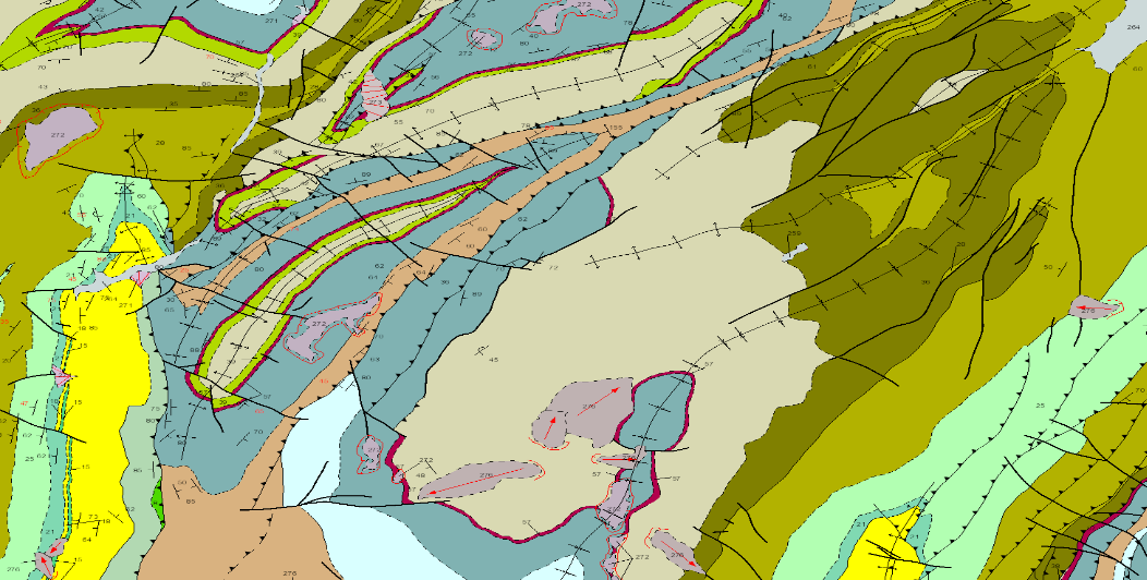
GEOLOGICAL CARTOGRAPHY is the representation of surface materials on the basis of their lithological, stratigraphic, structural, age, etc. characteristics. It is composed of the following levels of information: Z1000MRGEO: Cartographic units, differentiated geological enclosures; Z1000MPGEO: Geological enclosure labels; Z1000MLGEO: Auxiliary anchor lines of the geological polygon labels; Z1000MLCON: Contact and fault lines. Linear entities of diverse origin; Z1000MPBUZ: Points and labels of point entities and structural measures; Z1000CODEEDAD.
-
GEOLOGICAL CARTOGRAPHY is the representation of surface materials on the basis of their lithological, stratigraphic, structural, age, etc. characteristics. It is composed of the following levels of information: Z2100MRGEO: Cartographic units, differentiated geological enclosures; Z2100MPGEO: Geological enclosure labels; Z2100MLGEO: Auxiliary anchor lines of the geological polygon labels; Z2100MLCON: Contact and fault lines. Linear entities of diverse origin; Z2100MPBUZ: Points and labels of point entities and structural measures.
-
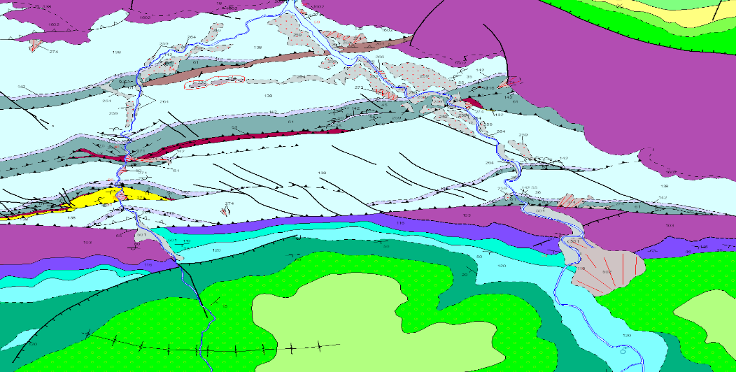
GEOLOGICAL CARTOGRAPHY is the representation of surface materials on the basis of their lithological, stratigraphic and structural characteristics. It is composed of the following levels of information: Z1700MRGEO: Cartographic units, differentiated geological enclosures; Z1700MPGEO: Geological enclosure labels; Z1700MLGEO: Auxiliary anchor lines of geological polygon labels; Z1700MLCON: Contact and fault lines. Linear entities of diverse origin; Z1700MPBUZ: Points and labels of point entities and structural measurements; Z1700CODEEDAD. The geographical scope of the project covers part of the following Autonomous Communities: Castilla- La Mancha, Castilla y León, Aragón, Comunidad Valenciana and La Rioja.
-
GEOLOGICAL CARTOGRAPHY is the representation of surface materials on the basis of their lithological, stratigraphic, structural, age, etc. characteristics. It is composed of the following levels of information: Z2914MRGEO: Cartographic units, differentiated geological enclosures; Z2914MPGEO: Geological enclosure labels; Z2914MLGEO: Auxiliary anchor lines of geological polygon labels; Z2914MLCON: Contact and fault lines. Linear entities of diverse origin; Z2914MPBUZ: Points and labels of point entities and structural measures.
-
GEOLOGICAL CARTOGRAPHY is the representation of surface materials on the basis of their lithological, stratigraphic, structural, age, etc. characteristics. It is composed of the following levels of information: Z2915MRGEO: Cartographic units, differentiated geological enclosures; Z2915MPGEO: Geological enclosure labels; Z2915MLGEO: Auxiliary anchor lines of geological polygon labels; Z2915MLCON: Contact lines and faults. Linear entities of diverse origin; Z2915MPBUZ: Points and labels of point entities and structural measures..
-
GEOLOGICAL CARTOGRAPHY is the representation of surface materials on the basis of their lithological, stratigraphic, structural, age, etc. characteristics. It is composed of the following levels of information: Z1500MRGEO: Cartographic units, differentiated geological enclosures; Z1500MPGEO: Geological enclosure labels; Z1500MLGEO: Auxiliary anchor lines of the geological polygon labels; Z1500MLCON: Contact and fault lines. Linear entities of diverse origin; Z1500MPBUZ: Points and labels of point entities and structural measures.
-
GEOLOGICAL CARTOGRAPHY is the representation of surface materials on the basis of their lithological, stratigraphic, structural, age, etc. characteristics. It is composed of the following levels of information: Z2911MRGEO: Cartographic units, geologic enclosures, geological cartographic units, differentiated geological enclosures; Z2911MPGEO: Geological enclosure labels; Z2911MLGEO: Auxiliary anchor lines of the geological polygon labels; Z2911MLCON: Contact and fault lines. Linear entities of diverse origin; Z2911MPBUZ: Points and labels of point entities and structural measures; Z2911MLCON: Linear entities of diverse origin; Z2911MPBUZ: Points and labels of point entities and structural measures.
-
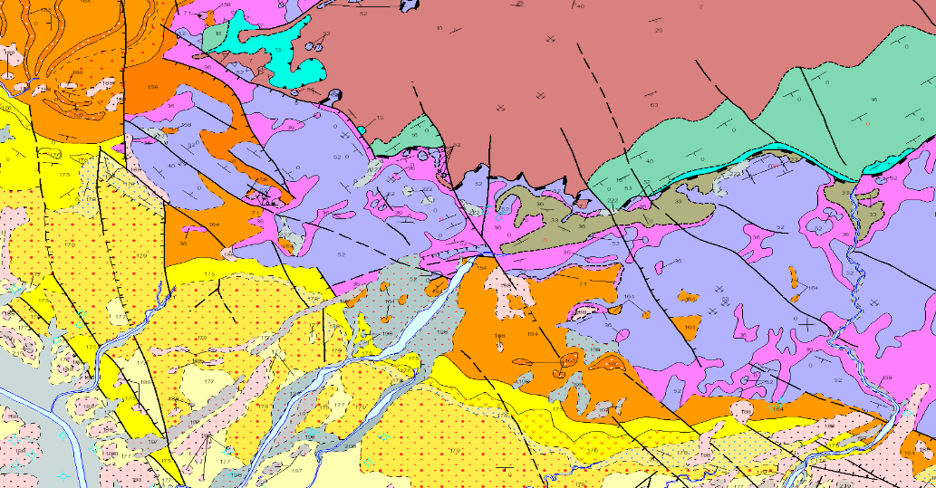
GEOLOGICAL CARTOGRAPHY is the representation of surface materials on the basis of their lithological, stratigraphic and structural characteristics. It is composed of the following levels of information: Z1400MRGEO: Cartographic units, differentiated geological enclosures; Z1400MPGEO: Geological enclosure labels; Z1400MLGEO: Auxiliary anchor lines of geological polygon labels; Z1400MLCON: Contact and fault lines. Linear entities of diverse origin; Z1400MPBUZ: Points and labels of point entities and structural measures; Z1400CODEEDAD. The geographical scope of the project covers part of the following Autonomous Communities: Extremadura, Castilla-La Mancha, Andalusia.