 Catalogo de metadatos del IGME
quaterly
Type of resources
Available actions
Topics
Provided by
Years
Formats
Representation types
Update frequencies
status
Scale
-
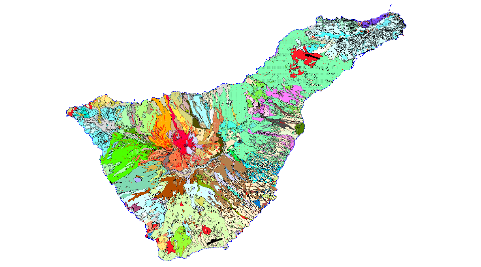
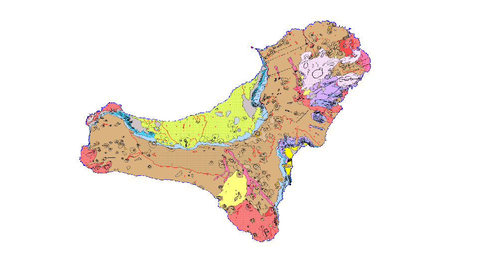
La CARTOGRAFÍA GEOLÓGICA es la representación de los materiales de la superficie en base a sus características litológicas, estratigráficas, estructurales, de antigüedad, etc. Se compone de los siguiente niveles de información: Z2913MRGEO: Unidades cartográficas, recintos geológicos diferenciados; Z2913MPGEO: Etiquetas de los recintos geológicos; Z2913MLGEO: Líneas auxiliares de anclaje de las etiquetas de los polígonos geológicos ; Z2913MLCON: Líneas de contactos y fallas. Entidades lineales de origen diverso; Z2913MPBUZ: Puntos y etiquetas de entidades puntuales y medidas estructurales.
-
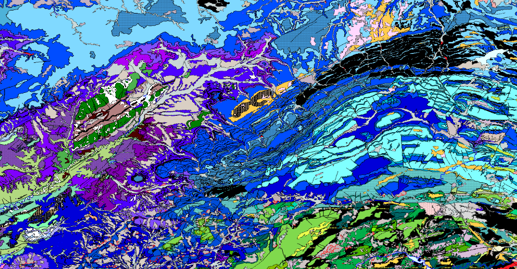
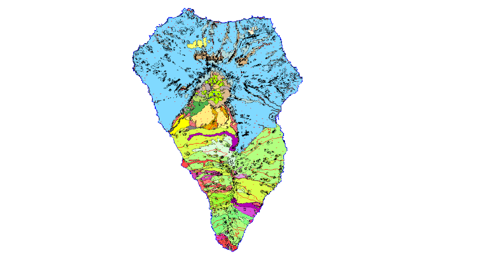
La CARTOGRAFÍA GEOLÓGICA es la representación de los materiales de la superficie en base a sus características litológicas, estratigráficas, estructurales, cronológicas, etc. Se compone de los siguiente niveles de información: Z1800MRGEO: Unidades cartográficas, recintos geológicos diferenciados; Z1800MPGEO: Etiquetas de los recintos geológicos; Z18006MLGEO: Líneas auxiliares de anclaje de las etiquetas de los polígonos geológicos; Z1800MLCON: Líneas de contactos y fallas. Entidades lineales de origen diverso; Z1800MPBUZ: Puntos y etiquetas de entidades puntuales y medidas estructurales.
-
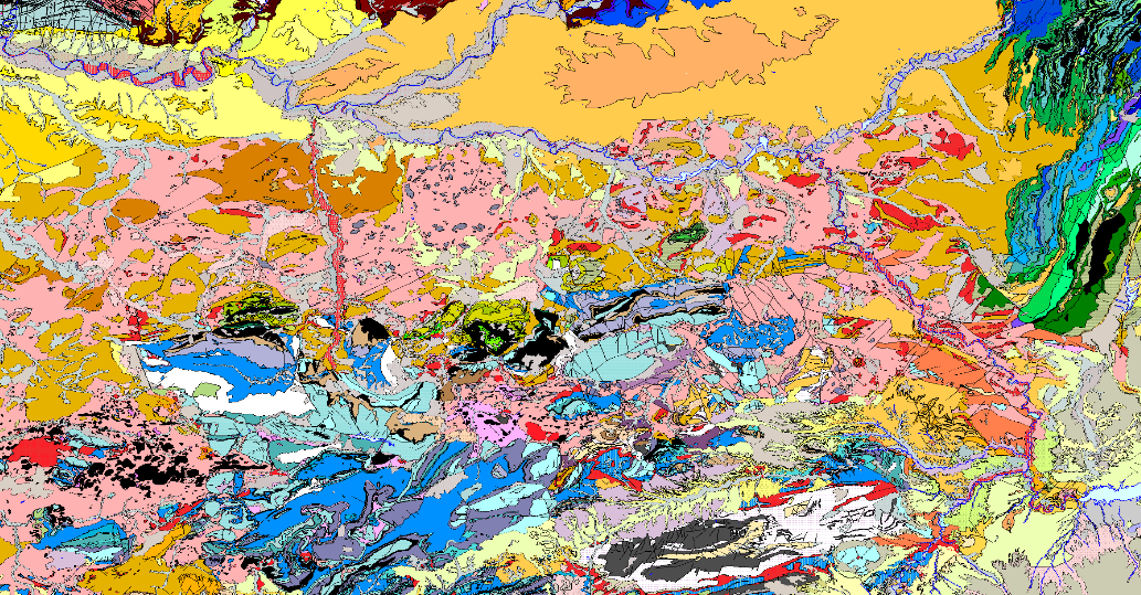
LA CARTOGRAFIA GEOLOGICA es la representación de los materiales de la superficie en base a sus características litológicas, estratigráficas, estructurales, de antigüedad, etc. Se compone de los siguiente niveles de información: Z2600MRGEO: Unidades cartográficas, recintos geológicos diferenciados; Z2600MPGEO: Etiquetas de los recintos geológicos; Z2600MLGEO: Líneas auxiliares de anclaje de las etiquetas de los polígonos geológicos ; Z2600MLCON: Líneas de contactos y fallas. Entidades lineales de origen diverso; Z2600MPBUZ: Puntos y etiquetas de entidades puntuales y medidas estructurales.
-
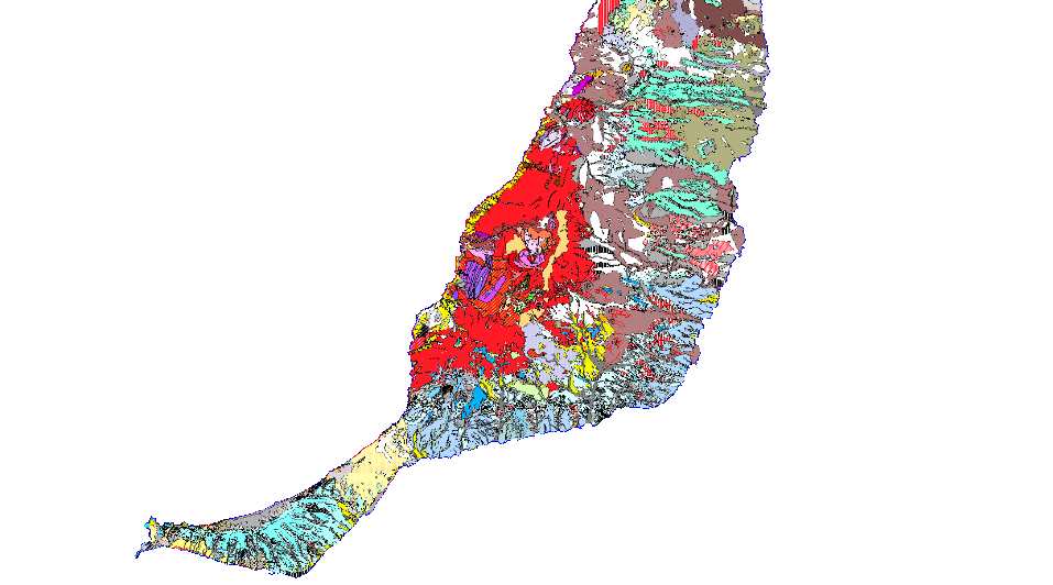
La CARTOGRAFÍA GEOLÓGICA es la representación de los materiales de la superficie en base a sus características litológicas, estratigráficas, estructurales, de antigüedad, etc. Se compone de los siguiente niveles de información: Z2911MRGEO: Unidades cartográficas, recintos geológicos diferenciados; Z2911MPGEO: Etiquetas de los recintos geológicos; Z2911MLGEO: Líneas auxiliares de anclaje de las etiquetas de los polígonos geológicos ; Z2911MLCON: Líneas de contactos y fallas. Entidades lineales de origen diverso; Z2911MPBUZ: Puntos y etiquetas de entidades puntuales y medidas estructurales
-
La CARTOGRAFÍA GEOLÓGICA es la representación de los materiales de la superficie en base a sus características litológicas, estratigráficas, estructurales, de antigüedad, etc. Se compone de los siguiente niveles de información: Z2916MRGEO: Unidades cartográficas, recintos geológicos diferenciados; Z2916MPGEO: Etiquetas de los recintos geológicos; Z2916MLGEO: Líneas auxiliares de anclaje de las etiquetas de los polígonos geológicos ; Z2916MLCON: Líneas de contactos y fallas. Entidades lineales de origen diverso; Z2916MPBUZ: Puntos y etiquetas de entidades puntuales y medidas estructurales.
-
La CARTOGRAFÍA GEOLÓGICA es la representación de los materiales de la superficie en base a sus características litológicas, estratigráficas, estructurales, de antigüedad, etc. Se compone de los siguiente niveles de información: Z2915MRGEO: Unidades cartográficas, recintos geológicos diferenciados; Z2915MPGEO: Etiquetas de los recintos geológicos; Z2915MLGEO: Líneas auxiliares de anclaje de las etiquetas de los polígonos geológicos ; Z2915MLCON: Líneas de contactos y fallas. Entidades lineales de origen diverso; Z2915MPBUZ: Puntos y etiquetas de entidades puntuales y medidas estructurales.
-
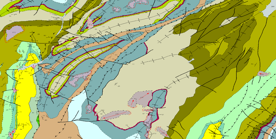
La CARTOGRAFÍA GEOLÓGICA es la representación de los materiales de la superficie en base a sus características litológicas, estratigráficas, estructurales, de antigüedad, etc. Se compone de los siguiente niveles de información: Z2211MRGEO: Unidades cartográficas, recintos geológicos diferenciados; Z2212MPGEO: Etiquetas de los recintos geológicos; Z12212MLGEO: Líneas auxiliares de anclaje de las etiquetas de los polígonos geológicos ; Z2212MLCON: Líneas de contactos y fallas. Entidades lineales de origen diverso; Z2212MPBUZ: Puntos y etiquetas de entidades puntuales y medidas estructurales.
-
La CARTOGRAFÍA GEOLÓGICA es la representación de los materiales de la superficie en base a sus características litológicas, estratigráficas, estructurales, de antigüedad, etc. Se compone de los siguiente niveles de información: Z1100MRGEO: Unidades cartográficas, recintos geológicos diferenciados; Z1100MPGEO: Etiquetas de los recintos geológicos; Z11006MLGEO: Líneas auxiliares de anclaje de las etiquetas de los polígonos geológicos ; Z1100MLCON: Líneas de contactos y fallas. Entidades lineales de origen diverso; Z1100MPBUZ: Puntos y etiquetas de entidades puntuales y medidas estructurales
-
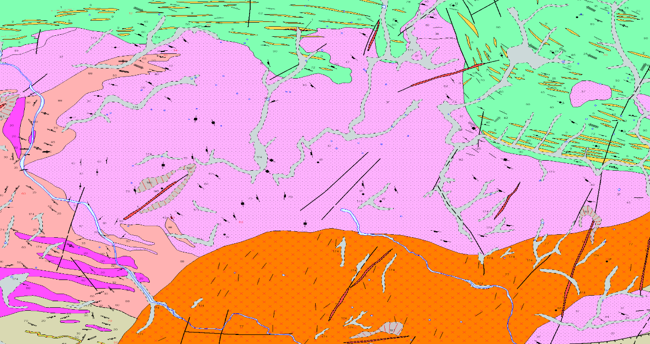
La CARTOGRAFÍA GEOLÓGICA es la representación de los materiales de la superficie en base a sus características litológicas, estratigráficas, estructurales, de antigüedad, etc. Se compone de los siguiente niveles de información: Z1300MRGEO: Unidades cartográficas, recintos geológicos diferenciados; Z1300MPGEO: Etiquetas de los recintos geológicos; Z13006MLGEO: Líneas auxiliares de anclaje de las etiquetas de los polígonos geológicos ; Z1300MLCON: Líneas de contactos y fallas. Entidades lineales de origen diverso; Z1300MPBUZ: Puntos y etiquetas de entidades puntuales y medidas estructurales.
-
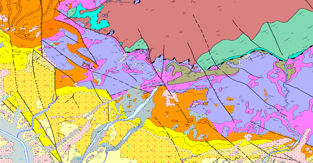
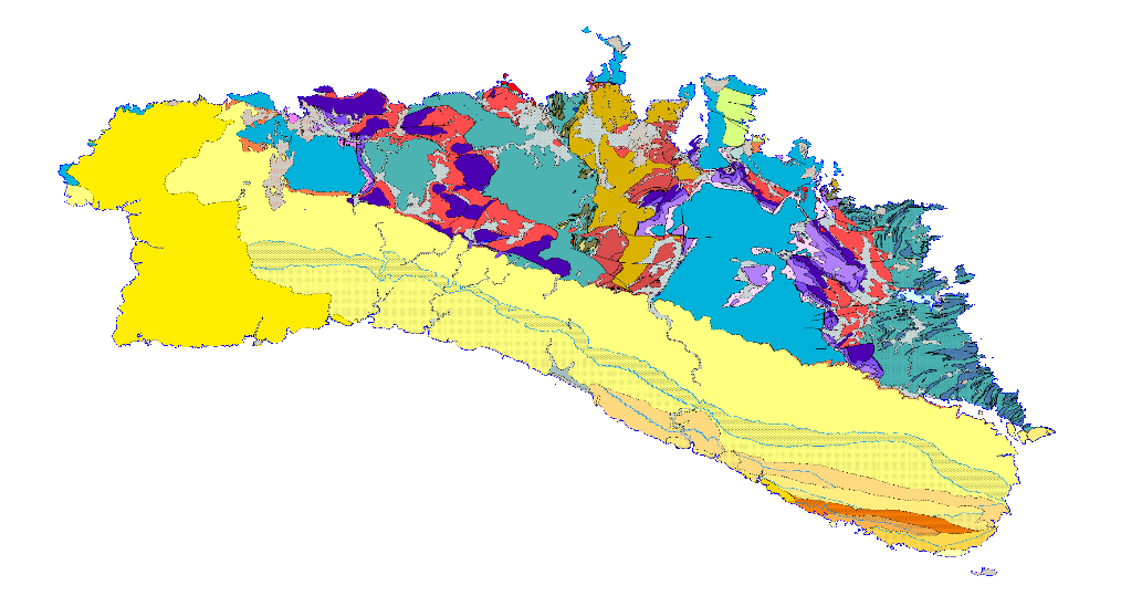
LA CARTOGRAFIA GEOLOGICA es la representación de los materiales de la superficie en base a sus características litológicas, estratigráficas, estructurales, de antigüedad, etc. Se compone de los siguiente niveles de información: Z2100MRGEO: Unidades cartográficas, recintos geológicos diferenciados; Z2100MPGEO: Etiquetas de los recintos geológicos; Z2100MLGEO: Líneas auxiliares de anclaje de las etiquetas de los polígonos geológicos ; Z2100MLCON: Líneas de contactos y fallas. Entidades lineales de origen diverso; Z2100MPBUZ: Puntos y etiquetas de entidades puntuales y medidas estructurales.