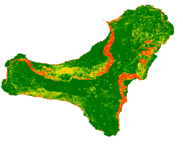
Web Service of Map of rockfall source areas, El Hierro (Canary Islands, Spain)
El mapa muestra una identificación probabilística de las áreas fuente de desprendimiento de rocas para la isla de El Hierro, elaborada con la combinación de múltiples modelos estadísticos
The map shows a probabilistic identification of rockfall source areas for El Hierro Island, prepared with the combination of multiple statistical models
Simple
Identification info
- Date (Publication)
- 2019-10-28
- Purpose
-
El mapa muestra en línea la probabilidad de que cada píxel sea un área de origen de desprendimientos de rocas y puede ser utilizado como entrada para la modelización regional de desprendimientos de rocas en El Hierro (Islas Canarias)
The map shows on line the probability of each single pixel to be a rock fall source area and can be used as input for rockfall regional modelling in El Hierro (Canary Island)
-
GEMET - INSPIRE themes, version 1.0
GEMET - INSPIRE themes, version 1.0
-
-
Geología
Geology
-
-
Tesauro IGME
IGME Thesaurus
-
-
Desprendimientos de rocas
Rockfalls
-
Trayectoria
Trajectory
-
Riesgo
Risk
-
Peligro
Hazard
-
Medio volcánico
Volcanic environment
-
Islas Canarias
Canary Islands
-
IGME
IGME
-
- Keywords
-
-
EGDI
EGDI
-
-
ISO - 19119 geographic services taxonomy
ISO - 19119 geographic services taxonomy
-
-
infoMapAccessService
infoMapAccessService
-
-
INSPIRE_SpatialDataServicesClassification
INSPIRE_SpatialDataServicesClassification
-
-
Servicio de acceso a mapas
Map Access Service
-
Servicio de gestión de modelos/información geográficos
Geographic model/information management service
-
-
Web Services Specifications
Web Services Specifications
-
-
WMS (Web Map Service)
WMS (Web Map Service)
-
WMS 1.3.0
WMS 1.3.0
-
WMS
WMS
-
- Access constraints
- Other restrictions
- Other constraints
- No limitations to public access.
- Use constraints
- Other restrictions
- Other constraints
-
LICENCIA DE USO: Condiciones de uso público y difusión de la información para la reutilización de los datos IGME http://www.igme.es/Ayuda/CondiUso.htm
LICENSE FOR USE: Conditions governing the public use and dissemination of the information for the re-use of the IGME data. http://www.igme.es/Ayuda/CondiUso.htm
- Service Type
- view
))
- Coupling Type
- Tight
Contains Operations
- Operation Name
-
GetCapabilities
- Distributed Computing Platforms
- Web services
Contains Operations
- Operation Name
-
GetMap
- Distributed Computing Platforms
- Web services
- Connect Point
- http://mapas.igme.es/gis/services/UGeoHaz/UGEOHAZ_ROCKFALLSOURCEAREAS_ELHIERRO/MapServer/WMSServer ( OGC:WMS-1.3.0-http-get-capabilities )
Contains Operations
- Operation Name
-
GetFeatureInfo
- Distributed Computing Platforms
- Web services
- Connect Point
- http://mapas.igme.es/gis/services/UGeoHaz/UGEOHAZ_ROCKFALLSOURCEAREAS_ELHIERRO/MapServer/WMSServer ( OGC:WMS-1.3.0-http-get-capabilities )
- Unique resource identifier
- EPSG:4258
- Unique resource identifier
- EPSG:32628
- Distribution format
-
- OnLine resource
- Rockfall Map Web Service, El Hierro (Canary Islands, Spain) ( OGC:WMS-1.3.0-http-get-capabilities )
- Hierarchy level
- Service
- Other
-
Servicio de visualización
Conformance result
- Date (Publication)
- 2009-10-19
- Explanation
-
Consultar el reglamento mencionado
See the above-mentioned regulation
- Pass
- No
Conformance result
- Date (Publication)
- 2010-12-08
- Explanation
-
Consultar el reglamento mencionado
See the above-mentioned regulation
- Pass
- No
Conformance result
- Date (Publication)
- 2008-12-04
Identifier
- Explanation
-
Consultar el reglamento mencionado
See the above-mentioned regulation
- Pass
- Yes
- File identifier
- ESPIGMESERVICIOROCKFALLSOURCEAREASELHIERRO20191031 XML
- Metadata language
- Spanish; Castilian
- Character set
- UTF8
- Hierarchy level
- Service
- Hierarchy level name
-
Servicio
- Date stamp
- 2022-10-04T13:27:45
- Metadata standard name
-
Reglamento (CE) Nº 1205/2008 de Inspire, "Perfil IGME"
- Metadata standard version
-
2.0
http://www.igme.es
Overviews

Spatial extent
))
Provided by

 Catalogo de metadatos del IGME