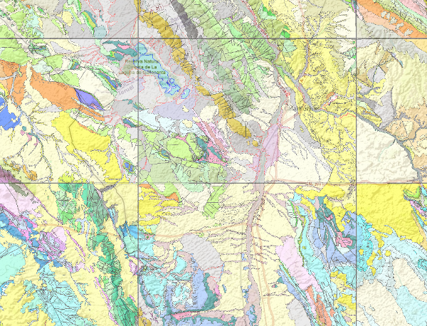
Geological Map of Spain, MAGNA
El Mapa Geológico Nacional (MAGNA), realizado entre 1972 y 2003 por el Instituto Geológico y Minero de España se distribuye en hojas 1:50.000 (1:25.000 en los casos particulares de Canarias, Ibiza-Formentera, Menorca, Ceuta y Melilla). En el Mapa Geológico se representa la naturaleza de los materiales (rocas y sedimentos) que aparecen en la superficie terrestre, su distribución espacial y las relaciones geométricas entre las diferentes unidades cartográficas.
The National Geological Map (MAGNA), was made between 1972 and 2003 by the Geological Survey of Spain. It is distributed in sheets 1: 50.000 (1: 25.000 in particular cases of the Canary Islands, Ibiza-Formentera, Menorca, Ceuta and Melilla). The geological map shows the nature of materials (rocks and sediments) that appear on the surface, their spatial distribution and geometric relationships between the different cartographic units represented.
Simple
Identification info
- Date (Publication)
- 2009-03-01
-
Tesauro IGME
Tesauro IGME
-
-
Geología general.geología
Geología general.geología
-
Estratigrafía.litoestratigrafía
Estratigrafía.litoestratigrafía
-
Estratigrafía.cronoestratigrafía
Estratigrafía.cronoestratigrafía
-
Geología general.tectonita
Geología general.tectonita
-
Geomorfología y Geología del Cuaternario.geomorfología
Geomorfología y Geología del Cuaternario.geomorfología
-
Geomorfología y Geología del Cuaternario.morfogénesis
Geomorfología y Geología del Cuaternario.morfogénesis
-
Geomorfología y Geología del Cuaternario.formación superficial
Geomorfología y Geología del Cuaternario.formación superficial
-
Geomorfología y Geología del Cuaternario.mapa geomorfológico
Geomorfología y Geología del Cuaternario.mapa geomorfológico
-
Geología general.mapa geológico
Geología general.mapa geológico
-
- Keywords
-
-
España
Spain
-
EGDI
EGDI
-
EGDI-selection
EGDI-selection
-
-
GEMET
GEMET
-
-
MEDIO NATURAL, MEDIO ANTRÓPICO
MEDIO NATURAL, MEDIO ANTRÓPICO
-
LITOSFERA (suelo, procesos geológicos)
LITOSFERA (suelo, procesos geológicos)
-
litosfera
litosfera
-
rocas
rocas
-
-
ISO - 19119 geographic services taxonomy, 1.0
ISO - 19119 geographic services taxonomy, 1.0
-
-
infoMapAccessService
infoMapAccessService
-
-
CEOLocation
CEOLocation
-
-
COUNTRIES
COUNTRIES
-
SPAIN
SPAIN
-
- Keywords
-
-
IGME
IGME
IGME
-
IDEE
IDEE
IDEE
-
España
España
Spain
-
MAGNA
MAGNA
MAGNA
-
MAGNA50
MAGNA50
MAGNA50
-
-
Especificaciones de Servicios Web
Especificaciones de Servicios Web
-
-
OGC (Open Geospatial Consortium)
OGC (Open Geospatial Consortium)
-
WMS (Web Map Service)
WMS (Web Map Service)
-
WMS 1.3.0
WMS 1.3.0
-
OGC
OGC
-
WMS
WMS
-
- Access constraints
- Other restrictions
- Other constraints
- Sin limitaciones al acceso público.
- Use constraints
- Other restrictions
- Other constraints
-
LICENCIA DE USO: Condiciones de uso público y difusión de la información para la reutilización de los datos IGME http://www.igme.es/Ayuda/CondiUso.htm
LICENCIA DE USO: Condiciones de uso público y difusión de la información para la reutilización de los datos IGME http://www.igme.es/Ayuda/CondiUso.htm
- Service Type
- view
))
- Coupling Type
- Tight
Contains Operations
- Operation Name
-
GetCapabilities
- Distributed Computing Platforms
- Web services
Contains Operations
- Operation Name
-
GetMap
- Distributed Computing Platforms
- Web services
Contains Operations
- Operation Name
-
GetFeatureInfo
- Distributed Computing Platforms
- Web services
- Operates On
- Reference system identifier
-
urn:ogc:def:crs:EPSG
/
http://www.opengis.net/def/crs/EPSG/0/23030
European Petroleum Surgey Group 1986-01-01
- Reference system identifier
- urn:ogc:def:crs:EPSG / http://www.opengis.net/def/crs/EPSG/0/6230
- Reference system identifier
- urn:ogc:def:crs:EPSG / http://www.opengis.net/def/crs/EPSG/0/23029
- Reference system identifier
- urn:ogc:def:crs:EPSG / http://www.opengis.net/def/crs/EPSG/0/23031
- Reference system identifier
- Pico de las Nieves/ UTM zona 28
- OnLine resource
- Enlace al GetCapabilities del servicio web donde se aloja el producto ( OGC:WMS-1.3.0-http-get-capabilities )
- Hierarchy level
- Service
- Other
-
Servicio web de datos espaciales. Servicio de visualización
Conformance result
- Date (Publication)
- 2009-10-20
- Explanation
-
See referred specification
See referred specification
See referred specification
- Pass
- No
- File identifier
- ESPIGMESERVICIOMAGNA502011020420000 XML
- Metadata language
- Spanish; Castilian
- Character set
- UTF8
- Hierarchy level
- Service
- Hierarchy level name
-
Servicio
- Date stamp
- 2022-04-05T09:52:36
- Metadata standard name
-
Reglamento (CE) Nº 1205/2008 de Inspire, "Perfil IGME"
- Metadata standard version
-
2.0
http://www.igme.es
Overviews

Spatial extent
))
Provided by

 Catalogo de metadatos del IGME