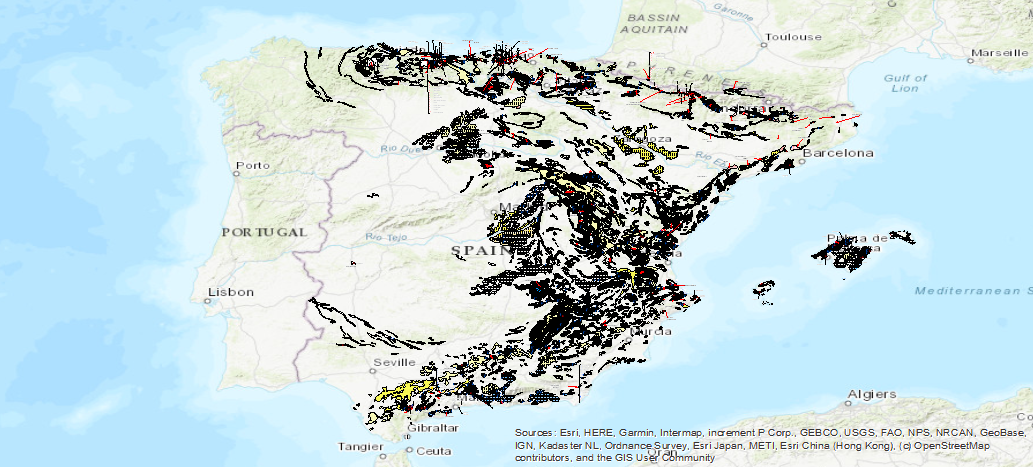
Service of visualization (WMS) of the Map of the Karst of Spain in scale 1:1.000.000
Servicio de visualización del Mapa del Karst en España a escala 1:1.000.000, que recoge las diferentes litologías 'karstificables' indicando su tipo (carbonatos, yesos y detríticos,) y la intensidad de karstificación en cada una de las zonas. También se incluyen cuevas, poljes, surgencias y otras entidades hidrogeológicas y geomorfológicas vinculadas a los procesos de karstificación.
Service of visualization of the Map of the Karst in Spain on a scale 1:1.000.000, which gathers the different 'karstifiable' lithologies indicating their type (carbonates, gypsums and detritus), and the intensity of karstification in each one of the zones. Also included are caves, poles, outcrops and other hydrogeological and geomorphological entities linked to karstification processes.
Simple
Identification info
- Date (Creation)
- 2019-07-01
- Purpose
-
Disponibilidad on-line del Mapa de Karst de España a escala 1:1.000.000
On-line availability of the Karst Map of Spain at 1:1.000.000 scale.
-
Tesauro IGME
IGME Thesaurus
-
-
IGME
IGME
-
Karst
Karst
-
Caliza
Limestone
-
Dolomía
Dolomite
-
Yeso
Gypsum
-
Agua subterránea
Groundwater
-
Acuífero
Aquifer
-
Manantial
Spring
-
Sugencia
Exsurgence
-
Travertino
Travertine
-
Disolución
Dissolution
-
Dolina
Dolines
-
Caverna
Cavern
-
Hundimiento
Collapse
-
Lapiaz
Karren
-
Geomorfología
Geomorphology
-
Riesgo natural
Natural risk
-
España
Spain
-
- Keywords
-
-
Detrítico
Detritic
-
Karstificación
Karstification
-
Polje
Polje
-
Sima
Sima
-
Sumidero
Sinkhole
-
Torca
Torca
-
Exokarst
Exokarst
-
- Keywords
-
-
IDEE
IDEE
-
- Keywords
-
-
EGDI
EGDI
-
- Keywords
-
-
EGDI-selection
EGDI-selection
-
- Keywords
-
-
WMS
WMS
-
-
Especificaciones de Servicios Web
Web Services Specifications
-
-
OGC (Open Geospatial Consortium)
OGC (Open Geospatial Consortium)
-
WMS (Web Map Service)
WMS (Web Map Service)
-
WMS 1.3.0
WMS 1.3.0
-
OGC
OGC
-
WMS
WMS
-
-
ISO - 19119 geographic services taxonomy
ISO - 19119 geographic services taxonomy
-
-
infoMapAccessService
infoMapAccessService
-
-
INSPIRE_SpatialDataServicesClassification
INSPIRE_SpatialDataServicesClassification
-
-
Servicio de acceso a mapas
Map access service
-
Servicio de gestión de modelos/información geográficos
Geographic Model/Information Management Service
-
- Access constraints
- Other restrictions
- Other constraints
- No Limitations
- Use constraints
- Other restrictions
- Other constraints
-
LICENCIA DE USO: Condiciones de uso público y difusión de la información para la reutilización de los datos IGME http://www.igme.es/Ayuda/CondiUso.htm
LICENSE OF USE: Conditions of public use and dissemination of information for the reuse of IGME data http://www.igme.es/Ayuda/CondiUso.htm
- Service Type
- view
))
- Coupling Type
- Tight
Contains Operations
- Operation Name
-
GetCapabilities
- Distributed Computing Platforms
- Web services
- Connect Point
- http://mapas.igme.es/gis/services/Cartografia_Tematica/IGME_Karst_1M/MapServer/WMSServer ( OGC:WMS-1.3.0-http-get-capabilities )
Contains Operations
- Operation Name
-
GetMap
- Distributed Computing Platforms
- Web services
- Connect Point
- http://mapas.igme.es/gis/services/Cartografia_Tematica/IGME_Karst_1M/MapServer/WMSServer ( OGC:WMS-1.3.0-http-get-map )
Contains Operations
- Operation Name
-
GetFeatureInfo
- Distributed Computing Platforms
- Web services
- Connect Point
- http://mapas.igme.es/gis/services/Cartografia_Tematica/IGME_Karst_1M/MapServer/WMSServer ( OGC:WMS-1.3.0-http-get-featureinfo )
- Unique resource identifier
- CRS:84
- Unique resource identifier
- EPSG:4258
- Unique resource identifier
- EPSG:4230
- Unique resource identifier
- EPSG:4230
- Unique resource identifier
- EPSG:23028
- Unique resource identifier
- EPSG:23029
- Unique resource identifier
- EPSG:23030
- Unique resource identifier
- EPSG:23031
- Unique resource identifier
- EPSG:25828
- Unique resource identifier
- EPSG:25829
- Unique resource identifier
- EPSG:25830
- Unique resource identifier
- EPSG:25831
- Distribution format
-
-
image/png
(
not applicable
)
-
image/jpeg
(
not applicable
)
-
image/tiff
(
not applicable
)
-
image/gif
(
not applicable
)
-
image/bmp
(
not applicable
)
-
image/png
(
not applicable
)
- OnLine resource
- Servicio de visualización (WMS) del Mapa del Karst de España a escala 1:1.000.000 ( OGC:WMS-1.3.0-http-get-capabilities )
- Hierarchy level
- Service
- Other
-
Servicio web de datos espaciales. Servicio de visualización
Conformance result
- Date (Publication)
- 2009-10-19
- Explanation
-
Consultar el reglamento mencionado
Consult the above-mentioned regulation
- Pass
- No
Conformance result
Conformance result
Conformance result
- Date (Publication)
- 2008-12-03
- Explanation
-
Consultar el reglamento mencionado
Consult the above-mentioned regulation
- Pass
- Yes
- File identifier
- ESPIGMESERVICIOKARST100020200714 XML
- Metadata language
- Spanish; Castilian
- Character set
- UTF8
- Hierarchy level
- Service
- Hierarchy level name
-
Servicio
- Date stamp
- 2022-12-20T10:54:45
- Metadata standard name
-
Reglamento (CE) Nº 1205/2008 de Inspire, "Perfil IGME"
- Metadata standard version
-
2.0
http://www.igme.es
Overviews

Spatial extent
))
Provided by

 Catalogo de metadatos del IGME