 Catalogo de metadatos IGME-CSIC
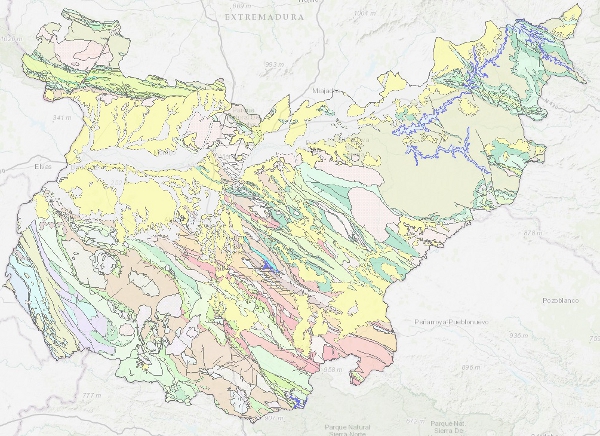
Geological Map of Badajoz at scale 1:200.000
Map with the chronolithostratigraphic and igneous units of the province of Badajoz grouped together as a support for the mapping of mineral resources in the province. The contacts between the different cartographic units have been classified as "stratigraphic contact" and "intrusive contact". The tectonic structure is expressed by faults.
Simple
- Alternate title
-
GeoBadajoz 200
- Date (Creation)
- 2003-01-01
- Date (Publication)
- 2006-01-01
- Edition
-
1ª Edición
- Edition date
- 1983-01-01
- Citation identifier
- 63107
- Presentation form
- Digital map
- Purpose
-
Support for the mapping of mineral resources in the province.
- Credit
-
Author: Pedro Florido Laraña
- Status
- Completed
- Point of contact
-
Organisation name Individual name Electronic mail address Role Geological Survey of Spain (IGME-CSIC)
Iván Martín Méndez
Point of contact
- Maintenance and update frequency
- Not planned
-
IGME Thesaurus
-
-
General geology.geology
-
Stratigraphy.chronostratigraphy
-
General geology.litology
-
General geology.rock.sedimentary rock
-
Systematics of metamorphic rocks.metamorphic rock
-
General geology.rock.crystalline rock.igneous rock
-
Structural geology.fault
-
General geology.rock
-
Stratigraphy Systematics.Proterozoic
-
Stratigraphy systematics.Palaeozoic
-
Systematics of Stratigraphy.Cenozoic
-
-
GEMET
-
-
NATURAL ENVIRONMENT, ANTHROPIC ENVIRONMENT
-
LITHOSPHERE (soil, geological processes)
-
lithosphere
-
rocks
-
- Specific usage
-
Support for metallogenic mapping of the province of Bazajoz
- User contact info
-
Organisation name Individual name Electronic mail address Role Geological Survey of Spain (IGME-CSIC)
Point of contact
- Access constraints
- Other restrictions
- Other constraints
- No limitations on public access
- Use constraints
- Other restrictions
- Other constraints
-
LICENCE OF USE: Conditions of public use and dissemination of information for the re-use of IGME data. https://www.igme.es/condiciones-de-uso/
- Title
-
Geological Map of Badajoz at scale 1:200.000
- Date (Publication)
- 2008-01-01
- Cited responsible party
-
Organisation name Individual name Electronic mail address Role Geological Survey of Spain (IGME-CSIC)
Point of contact
- Aggregate Datasetindentifier
-
63106
Geological Survey of Spain (IGME) 1979-01-01
- Association Type
- Cross reference
- Title
-
Geological Map of Spain at a scale of 1:50.000, MAGNA
- Date (Revision)
- 1991-01-01
- Cited responsible party
-
Organisation name Individual name Electronic mail address Role Instituto Geológico y Minero de España (IGME-CSIC)
Point of contact
- Aggregate Datasetindentifier
- 20000
- Association Type
- Larger work citation
- Spatial representation type
- Vector
- Denominator
- 200000
- Language
- Spanish; Castilian
- Character set
- 8859 Part 1
- Topic category
-
- Geoscientific information
- Description
-
Provincia de Badajoz
))
- Supplemental Information
-
Support for the mapping of mineral resources in the province.
- Unique resource identifier
- EPSG:6230
- Unique resource identifier
- EPSG:23030
- Unique resource identifier
- EPSG:4258
- Distribution format
-
Name Version Mapa digital: SHP - ArcView ShapeFile
Unknown
Mapa digital: ARCC - Coverage of Arc-Info
Unknown
Mapa digital: ARCE - ARC/INFO Export format
Unknown
Mapa digital: PDF - Portable Document Format
Unknown
Mapa en papel
Unknown
Servicio web: WMS - Web Map Service
1.3.0
Distributor
- Distributor contact
-
Organisation name Individual name Electronic mail address Role Instituto Geológico y Minero de España (IGME-CSIC)
Distributor
- Distributor format
-
Name Version Mapa digital: SHP - ArcView ShapeFile
-
Mapa digital: ARCC - Coverage of Arc-Info
-
Mapa digital: ARCE - ARC/INFO Export format
-
Mapa digital: PDF - Portable Document Format
-
Distributor
- Distributor contact
-
Organisation name Individual name Electronic mail address Role Centro de Documentación del Instituto Geológico y Minero de España (IGME-CSIC)
Distributor
- Distributor format
-
Name Version Mapa en papel
-
Distributor
- Distributor contact
-
Organisation name Individual name Electronic mail address Role Vicedirección Técnica de Sistemas de Información Geológica del Instituto Geológico y Minero del España (IGME-CSIC)
Distributor
- Distributor format
-
Name Version Servicio web: WMS - Web Map Service
1.3.0
- OnLine resource
-
Protocol Linkage Name OGC:WMS-1.1.1-http-get-capabilities
http://mapas.igme.es/gis/services/Cartografia_Geologica/IGME_GeologicoBadajoz_200/MapServer/WMSServer?Request=GetCapabilities&Service=WMS Link to the GetCapabilities of the web service hosting the product
WWW:LINK-1.0-http--related
https://mapas.igme.es/Servicios/default.aspx#IGME_GeologicoBadajoz_200 Link to the product page on the IGME web site
- Name
- CDROM
- Hierarchy level
- Dataset
Completeness commission
- Name of measure
-
Duplicated phenomena
- Measure description
-
Geometric and topological control using the tools of the GIS application.
Conformance result
- Title
-
Geometric and topological control using the tools of the GIS application.
- Date (Revision)
- 2006-01-01
- Explanation
-
Error rate 0 %
- Pass
- Yes
Completeness omission
- Name of measure
-
Lack of phenomena
- Measure description
-
Visual spot check and cross-checking of spatial information with attribute tables.
Conformance result
- Title
-
Visual spot check and cross-checking of spatial information with attribute tables.
- Date (Revision)
- 2006-01-01
- Explanation
-
Digital comparative validation and visual comparative check of the original map and the digitised map. Validation with error rate < 1%.
- Pass
- Yes
Conceptual consistency
- Name of measure
-
Degree of approximation of the digital data with the conceptual model. Distribution of phenomena in classes.
- Measure description
-
Manual verification
Conformance result
- Title
-
MAGNA geological mapping data model in digital format.
- Date (Revision)
- 2012-02-01
- Explanation
-
Check that the digital information is consistent with the standards that conceptually define it. Consult the standard
- Pass
- Yes
Conceptual consistency
- Name of measure
-
Degree of approximation of the digital data with the conceptual model. Properties of the phenomena
- Measure description
-
Automatic verification
Conformance result
- Title
-
MAGNA geological mapping data model in digital format.
- Date (Revision)
- 2012-02-01
- Explanation
-
Check that the digital information is consistent with the standards that conceptually define it. Consult the standard.
- Pass
- Yes
Format consistency
- Name of measure
-
Degree of approximation of the data to the established physical structure.
- Measure description
-
Automatic verification
Conformance result
- Title
-
Especificaciones para la digitalización de la cartografía geológica MAGNA.
- Date (Revision)
- 2012-02-01
- Explanation
-
Check that the digital information is consistent with the standards that conceptually define it. Consult the standard
- Pass
- Yes
Absolute external positional accuracy
- Name of measure
-
Absolute external accuracy
- Measure description
-
Mean square error in the registration of the map to be digitised.
Conformance result
- Title
-
Mean square error in the map registration to digitise
- Date (Revision)
- 2006-01-01
- Explanation
-
Verification that the positional error is less than that required by the scale of the map > 100
- Pass
- Yes
Thematic classification correctness
- Name of measure
-
Absence of errors in the assignment of classes to phenomena.
- Measure description
-
Comparative study with the original mapping. Random sampling
Conformance result
- Title
-
Comparative study with the original mapping. Random sampling
- Date (Revision)
- 2006-01-01
- Explanation
-
Digital comparative validation and visual comparative check of the original map and the digitised map. Validation with error rate < 1%.
- Pass
- Yes
Thematic classification correctness
- Name of measure
-
Absence of errors in the assignment of values.
- Measure description
-
Comparative study with original map.
Conformance result
- Title
-
Comparative study with original map.
- Date (Revision)
- 2006-01-01
- Explanation
-
Digital comparative validation and comparative visual check of the original map and the digitised map. Error rate 1%. Error area < 0.1% in cartographic units.
- Pass
- Yes
Non quantitative attribute accuracy
- Name of measure
-
Absence of errors in the assignment of values.
- Measure description
-
Comparative study with original map
Conformance result
- Title
-
Comparative study with original map
- Date (Revision)
- 2006-01-01
- Explanation
-
Digital comparative validation and comparative visual check of the original map and the digitised map. Error rate 1%. Error area < 0.1% in cartographic units.
- Pass
- Yes
Conformance result
Conformance result
Conformance result
- Date (Publication)
- 2010-12-08
Citation identifier
- Explanation
-
Consultar el reglamento
- Pass
- No
- Statement
-
Map based on the National Geological Map at a scale of 1:50,000 (second series), MAGNA, with the incorporation of data from studies carried out by the IGME and field work. Digitisation carried out in 2003. Normalisation and generation of symbolised files (.lyr) and cartography, in version 8.3 of ArcGis, in 2003.
- Description
-
Compilation and analysis of previous information:
Compilation of MAGNA geological information and of work carried out in the area covered by the sheet carried out subsequent to the MAGNA sheets.
- Description
-
Production of the map:
Study of the cartographic units and revision of the samples.
Elaboration of the chronolithostratigraphic legend taking into account the objective of the geological base, which is to elaborate a metalogenetic map.
Correlation between the cartographic units of the MAGNA sheets and the chronolithostratigraphic legend of the 1:200.000 scale map.
Spatial adjustment between sheet boundaries.
Adjustment to the selected topographic base.
Drawing of the geological map at 1:200.000 scale.
- Description
-
Process of digitalisation of the information:
Analysis of the entities present in the cartography. Assignment of codes.
Digitisation of geological contacts and faults. Generation of the enclosures that constitute the cartographic units. Digitisation of the rest of the geological entities. Digitisation of the chronolithostratigraphic legend.
Error control and correction.
- Description
-
The rock units of the sheet separated by different types of contacts are represented, together with the tectonic structure, faults and map traces of folds, the orientation and dip of planar and linear elements contained in the rocks, structural and textural singularities of igneous and metamorphic rocks, water points, mineral deposits and indications, presence of fossils and other elements of punctual representation.
- Denominator
- 50000
- Title
-
Geological Map of Spain scale 1:50.000 MAGNA
- Date (Creation)
- 1971-01-01
Citation identifier
- Cited responsible party
-
Organisation name Individual name Electronic mail address Role Instituto Geológico y Minero de España (IGME-CSIC)
Martín-Serrano García, Ángel
Originator Distributor
- Presentation form
- Hardcopy map
- Presentation form
- Digital map
Metadata
- File identifier
- ESPIGMEGEOBADAJOZ2002010090263107 XML
- Metadata language
- Spanish; Castilian
- Character set
- UTF8
- Hierarchy level
- Dataset
- Date stamp
- 2026-04-15T11:59:42.599624Z
- Metadata standard name
-
Reglamento (CE) Nº 1205/2008 de Inspire, "Perfil IGME"
- Metadata standard version
-
2.0
- Metadata author
-
Organisation name Individual name Electronic mail address Role Instituto Geológico y Minero de España (IGME-CSIC)
Leticia Vega Martín
Point of contact
- Other language
-
Language Character encoding English UTF8 Spanish; Castilian UTF8
)))