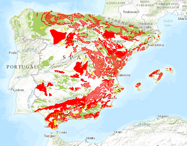
Thematic_cartography/IGME_MTerrain_1M
Mapa con la distribución geográfica de movimientos del terreno clasificados en cuatro grandes grupos: componente horizontal en zonas continentales, componente vertical en zonas continentales, áreas inestables ligadas a zonas litorales y movimientos relacionados con explotaciones mineras. También se incluyen las áreas continentales con procesos erosivos importantes.
Map showing the geographical distribution of ground movements classified into four main groups: horizontal component in continental areas, vertical component in continental areas, unstable areas linked to coastal areas and movements related to mining operations. Also included are continental areas with important erosive processes.
Simple
Identification info
- Date (Creation)
- 2010-08-16
- Date (Publication)
- 2010-08-16
- Status
- Completed
-
GEMET - INSPIRE themes, version 1.0
GEMET - INSPIRE themes, version 1.0
-
-
Geología
Geology
-
- Keywords
-
-
IGME
IGME
-
IDEE
IDEE
-
Movimientos del Terreno
Land Movements
-
España
Spain
-
- Keywords
-
-
IGME
IGME
-
- Keywords
-
-
EGDI
EGDI
-
-
INSPIRE_SpatialDataServicesClassification
INSPIRE_SpatialDataServicesClassification
-
-
Servicio de acceso a mapas
Map access service
-
infoMapAccessService
infoMapAccessService
-
Servicio de gestión de modelos/información geográficos
Geographic modelling/information management service
-
infoManagementService
infoManagementService
-
-
Especificaciones de Servicios Web
Web Services Specifications
-
-
OGC (Open Geospatial Consortium)
OGC (Open Geospatial Consortium)
-
WMS (Web Map Service)
WMS (Web Map Service)
-
WMS 1.3.0
WMS 1.3.0
-
OGC
OGC
-
WMS
WMS
-
- Access constraints
- Other restrictions
- Other constraints
- No limitations on public access.
- Use constraints
- Other restrictions
- Other constraints
-
LICENCIA DE USO: Condiciones de uso público y difusión de la información para la reutilización de los datos IGME http://www.igme.es/Ayuda/CondiUso.htm
LICENCE OF USE: Conditions of public use and dissemination of information for the re-use of IGME data. http://www.igme.es/Ayuda/CondiUso.htm
- Service Type
- view
))
- Coupling Type
- Ajustado
Contains Operations
- Operation Name
-
GetCapabilities
- Distributed Computing Platforms
- Web services
- Connect Point
- URL de acceso ( OGC Web Map Service )
Contains Operations
- Operation Name
-
GetMap
- Distributed Computing Platforms
- Web services
- Connect Point
- URL de acceso ( OGC Web Map Service )
Contains Operations
- Operation Name
-
GetFeatureInfo
- Distributed Computing Platforms
- Web services
- Connect Point
- URL de acceso ( OGC Web Map Service )
- Distribution format
-
- OnLine resource
- Link to GetCapabilities of the web service hosting the product ( OGC:WMS-1.3.0-http-get-capabilities )
- Hierarchy level
- Service
- Other
-
Servicio de visualización
Conformance result
- Date (Publication)
- 2009-10-19
- Explanation
-
Consultar el reglamento mencionado
Consult the regulation mentioned above
- Pass
- No
Conformance result
- Date (Publication)
- 2010-12-08
- Explanation
-
Consultar el reglamento
Consult the regulations
- Pass
- No
Conformance result
- Date (Publication)
- 2008-12-04
Identifier
- Explanation
-
Consultar el reglamento mencionado
Consult the regulation mentioned above
- Pass
- Yes
- File identifier
- ESPIGMESERVICIOMOVIMIENTOSDELTERRENO100020120404 XML
- Metadata language
- Spanish; Castilian
- Character set
- UTF8
- Hierarchy level
- Service
- Hierarchy level name
-
Servicio
- Date stamp
- 2022-10-07T10:49:32
- Metadata standard name
-
Reglamento (CE) Nº 1205/2008 de Inspire, "Perfil IGME"
- Metadata standard version
-
2.0
http://www.igme.es
Overviews

Spatial extent
))
Provided by

 Catalogo de metadatos del IGME