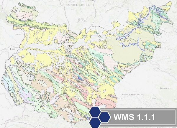
Geological Map of Badajoz at scale 1/200.000
Mapa con las unidades cronolitoestratigráficas e ígneas de la provincia de Badajoz agrupadas como soporte para la cartografía de reursos minerales de la provincia. Los contactos entre las disititntas unidades cartográficas se han clasificado en 'contacto estratigráfico' y 'contacto intrusivo'. La estructura tectónica está expresada mediante fallas.
Map with the chronolithostratigraphic and igneous units of the province of Badajoz grouped together as a support for the mapping of mineral resources in the province. The contacts between the different cartographic units have been classified as "stratigraphic contact" and "intrusive contact". The tectonic structure is expressed by faults.
Simple
- Date (Creation)
- 2009-03-01
- Date (Publication)
- 2009-03-01
- Status
- Completed
-
GEMET - INSPIRE themes, version 1.0
GEMET - INSPIRE themes, version 1.0
-
-
Geología
Geology
-
-
CEOLocation
CEOLocation
-
-
COUNTRIES
COUNTRIES
-
SPAIN
SPAIN
-
-
EuropeanTerritorialUnits
EuropeanTerritorialUnits
-
-
ESPAÑA
SPAIN
-
Extremadura
Extremadura
-
Badajoz
Badajoz
-
- Keywords
-
-
IGME
IGME
-
IDEE
IDEE
-
-
INSPIRE_SpatialDataServicesClassification
INSPIRE_SpatialDataServicesClassification
-
-
Servicio de acceso a mapas
Map access service
-
infoMapAccessService
infoMapAccessService
-
Servicio de gestión de modelos/información geográficos
Geographic modelling/information management service
-
infoManagementService
infoManagementService
-
-
Especificaciones de Servicios Web
Web Services Specification
-
-
OGC (Open Geospatial Consortium)
OGC (Open Geospatial Consortium)
-
WMS (Web Map Service)
WMS (Web Map Service)
-
WMS 1.3.0
WMS 1.3.0
-
OGC
OGC
-
WMS
WMS
-
- Access constraints
- Other restrictions
- Use constraints
- Other restrictions
- Other constraints
-
LICENCIA DE USO: Condiciones de uso público y difusión de la información para la reutilización de los datos IGME http://www.igme.es/Ayuda/CondiUso.htm
LICENCE OF USE: Conditions of public use and dissemination of information for the re-use of IGME data. http://www.igme.es/Ayuda/CondiUso.htm
- Service Type
- view
))
- Coupling Type
- Tight
Contains Operations
- Operation Name
-
GetCapabilities
- Distributed Computing Platforms
- Web services
- Connect Point
- URL de acceso ( OGC Web Map Service )
Contains Operations
- Operation Name
-
GetMap
- Distributed Computing Platforms
- Web services
- Connect Point
- URL de acceso ( OGC Web Map Service )
Contains Operations
- Operation Name
-
GetFeatureInfo
- Distributed Computing Platforms
- Web services
- Connect Point
- URL de acceso ( OGC Web Map Service )
- Operates On
- Date
- Keywords
-
- Distribution format
-
- OnLine resource
- Enlace al GetCapabilities del servicio web donde se aloja el producto ( OGC:WMS-1.3.0-http-get-capabilities )
- Hierarchy level
- Service
- Other
-
Servicio de visualización
Conformance result
- Date (Publication)
- 2009-10-19
- Explanation
-
Consultar el reglamento mencionado
Consult the regulation mentioned above
- Pass
- No
Conformance result
- Date (Publication)
- 2010-12-08
- Explanation
-
Consultar el reglamento
Consult the regulation
- Pass
- No
Conformance result
- Date (Publication)
- 2008-12-04
Identifier
- Explanation
-
Consultar el reglamento mencionado
Consult the regulation mentioned above
- Pass
- Yes
- File identifier
- ESPIGMESERVICIOGEOBADAJOZ2002011021763107 XML
- Metadata language
- Spanish; Castilian
- Character set
- UTF8
- Hierarchy level
- Service
- Hierarchy level name
-
Servicio
- Date stamp
- 2022-10-10T10:38:40
- Metadata standard name
-
Reglamento (CE) Nº 1205/2008 de Inspire, "Perfil IGME"
- Metadata standard version
-
2.0
http://www.igme.es
Overviews

Spatial extent
))
Provided by

 Catalogo de metadatos del IGME