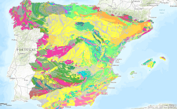
Cartografia_Geologica/IGME_Edades_1M
El mapa de geológico por edades de las unidades a escala 1:1.000.000 se ha generado a partir de la información de la columna cronolitoestratigráfica del mapa. En todas las unidades se ha especificado el Sistema, la Serie solo se ha cubierto en la mitad aproximadamente y el Piso es ocasional. En los casos en los que no se ha podido establecer un tramo cornoestratigráfico se ha optado por asignar el valor "sin determinar".
The geological age map of the units at a scale of 1:1,000,000 has been generated from the information in the chronolithostratigraphic column of the map. In all units the System has been specified, the Series has only been covered in about half of the units and the Floor is occasional. In cases where it has not been possible to establish a chronostratigraphic section, the value "undetermined" has been assigned.
Simple
Identification info
- Date (Creation)
- 2009-03-01
- Date (Publication)
- 2009-03-01
- Status
- Completed
-
GEMET - INSPIRE themes, version 1.0
GEMET - INSPIRE themes, version 1.0
-
-
Geología
Geology
-
-
CEOLocation
CEOLocation
-
-
COUNTRIES
COUNTRIES.
-
SPAIN
SPAIN
-
-
EuropeanTerritorialUnits
EuropeanTerritorialUnits
-
-
España
Spain
-
- Keywords
-
-
IGME
IGME
-
IDEE
IDEE
-
Edades
Ages.
-
- Keywords
-
-
EGDI
EGDI.
-
-
INSPIRE_SpatialDataServicesClassification
INSPIRE_SpatialDataServicesClassification
-
-
Servicio de acceso a mapas
Map access service
-
infoMapAccessService
infoMapAccessService
-
Servicio de gestión de modelos/información geográficos
Geographic modelling/information management service
-
infoManagementService
infoManagementService
-
-
Especificaciones de Servicios Web
Web Services Specifications
-
-
OGC (Open Geospatial Consortium)
OGC (Open Geospatial Consortium)
-
WMS (Web Map Service)
WMS (Web Map Service)
-
WMS 1.3.0
WMS 1.3.0
-
OGC
OGC
-
WMS
WMS
-
- Access constraints
- Other restrictions
- Other constraints
- No limitations on public access.
- Use constraints
- Other restrictions
- Other constraints
-
LICENCIA DE USO: Condiciones de uso público y difusión de la información para la reutilización de los datos IGME http://www.igme.es/Ayuda/CondiUso.htm
LICENCE OF USE: Conditions of public use and dissemination of information for the re-use of IGME data. http://www.igme.es/Ayuda/CondiUso.htm
- Service Type
- view
))
- Coupling Type
- Ajustado
Contains Operations
- Operation Name
-
GetCapabilities
- Distributed Computing Platforms
- Web services
- Connect Point
- URL de acceso ( OGC Web Map Service )
Contains Operations
- Operation Name
-
GetMap
- Distributed Computing Platforms
- Web services
- Connect Point
- URL de acceso ( OGC Web Map Service )
Contains Operations
- Operation Name
-
GetfeatureInfo
- Distributed Computing Platforms
- Web services
- Connect Point
- URL de acceso ( OGC Web Map Service )
- Distribution format
-
- OnLine resource
- Link to the GetCapabilities of the web service hosting the product ( OGC:WMS-1.3.0-http-get-capabilities )
- Hierarchy level
- Service
- Other
-
Servicio de visualización
Conformance result
- Date (Publication)
- 2009-10-19
- Explanation
-
Consultar el reglamento mencionado
Consult the regulation mentioned above
- Pass
- No
Conformance result
- Date (Publication)
- 2010-12-08
- Explanation
-
Consultar el reglamento
Consult the regulation mentioned above
- Pass
- No
Conformance result
- Date (Publication)
- 2008-12-04
Identifier
- Explanation
-
Consultar el reglamento mencionado
Consult the regulation mentioned above
- Pass
- Yes
- File identifier
- ESPIGMESERVICIOEDADESGEOLOGICAS100020110216260472 XML
- Metadata language
- Spanish; Castilian
- Character set
- UTF8
- Hierarchy level
- Service
- Hierarchy level name
-
Servicio
- Date stamp
- 2022-10-10T11:25:13
- Metadata standard name
-
Reglamento (CE) Nº 1205/2008 de Inspire, "Perfil IGME"
- Metadata standard version
-
2.0
http://www.igme.es
Overviews

Spatial extent
))
Provided by

 Catalogo de metadatos del IGME