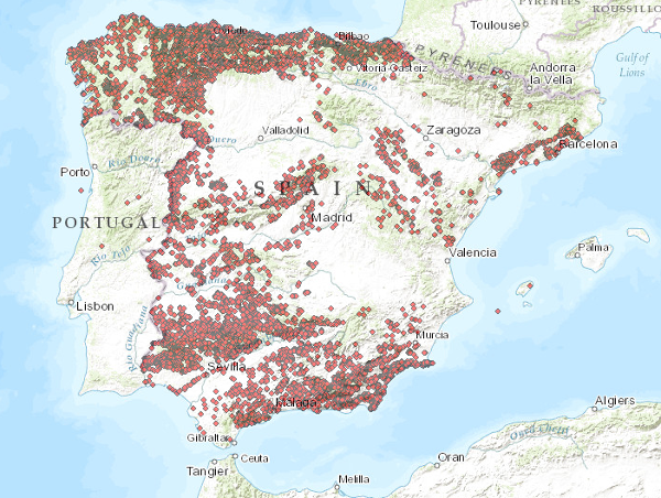
Visualisation Service (WMS) of the Mineral Resources Database (Metallogeny)
El servicio se compone de dos capas de puntos que simbolizan la posición de los indicios minerales para todo el territorio nacional. En función de la escala de visualización se ha creado dos capas de información. Indicios I: Se representa tan sólo la localización de los puntos. Visible a partir de escalas menores de 1:200.000. Indicios II: Los puntos son representados con una simbolización en función de distintos atributos. Visible a partir de escalas mayores de 1:200.000.. Los sistemas de referencia que ofrece este servicio son:CRS:84, EPSG:4326, EPSG:4258, EPSG:4230, EPSG:23028, EPSG:23029, EPSG:23030, EPSG:23031, EPSG:25828, EPSG:25829, EPSG:25830, EPSG:25831.
The service consists of two layers of dots symbolising the position of mineral occurrences for the entire national territory. Depending on the scale of visualisation, two layers of information have been created. Indications I: Only the location of the points is represented. Visible from scales smaller than 1:200.000. Indications II: The points are represented with a symbolisation according to different attributes. Visible from scales larger than 1:200,000. The reference systems offered by this service are:CRS:84, EPSG:4326, EPSG:4258, EPSG:4230, EPSG:23028, EPSG:23029, EPSG:23030, EPSG:23031, EPSG:25828, EPSG:25829, EPSG:25830, EPSG:25831
Simple
Identification info
- Date (Revision)
- 2014-05-01
- Status
- Completed
-
GEMET - Supergrupos, grupos y conceptos
GEMET - Supergroups, groups and concepts
-
-
Recursos minerales
Mineral resources
-
-
CEOLocation
CEOLocation
-
-
COUNTRIES
COUNTRIES
-
ESPAÑA
SPAIN
-
-
Tesauro IGME
IGME Thesaurus
-
-
Mapa metalogenético
Metallogenic map
-
Metalogenia
Metallogeny
-
Mineral
Mineral
-
Mineral Resources
Recursos minerales
-
Mapa de yacimientos minerales
Map of mineral deposits
-
Cartografía temática
Thematic cartography
-
Metalotecto
Metallothec
-
-
Minerals Intelligence Network for Europe register 1.0, 2014
Minerals Intelligence Network for Europe register 1.0, 2014
-
-
Indicios mineros
Mining indications
-
Yacimientos minerales
Mineral deposits
- Minerals4EU
- Mintell4EU
-
Metales base
Base metals
-
Minerales metálicos
Metallic minerals
-
Depósito mineral
Mineral Deposit
-
Indicio
Indications
-
- Keywords
-
-
WMS, IGME, Indicios Mineros
WMS, IGME, Mining Indices
-
- Keywords
-
-
EGDI
EGDI
-
- Keywords
-
-
EGDI-selection
EGDI-selection
-
-
INSPIRE_SpatialDataServicesClassification
INSPIRE_SpatialDataServicesClassification
-
-
Servicio de acceso a mapas
Map access service
-
Servicio de gestión de modelos/información geográficos
Geographic model/information management service
-
infoMapAccessService
infoMapAccessService
-
infoManagementService
infoManagementService
-
-
ISO - 19119 geographic services taxonomy, 1.0
ISO - 19119 geographic services taxonomy, 1.0
-
-
Servicio de acceso a mapas
Map access service
-
Servicio de gestión de modelos/información geográficos
Geographic model/information management service
-
infoMapAccessService
infoMapAccessService
-
infoManagementService
infoManagementService
-
-
Especificaciones de Servicios Web
Web Services Specifications
-
-
OGC
OGC
-
wms
wms
-
1.3.0
1.3.0
-
- Access constraints
- Other restrictions
- Other constraints
- No limitations on public access.
- Use constraints
- Other restrictions
- Other constraints
-
LICENCIA DE USO: Condiciones de uso público y difusión de la información para la reutilización de los datos IGME http://www.igme.es/Ayuda/CondiUso.htm
LICENCE OF USE: Conditions of public use and dissemination of information for the re-use of IGME data. http://www.igme.es/Ayuda/CondiUso.htm
- Service Type
- view
))
- Coupling Type
- Tight
Contains Operations
- Operation Name
-
GetCapabilities
- Distributed Computing Platforms
- Web services
- Connect Point
- URL de acceso ( OGC Web Map Service )
Contains Operations
- Operation Name
-
GetMap
- Distributed Computing Platforms
- Web services
- Connect Point
- http://mapas.igme.es/gis/services/BasesDatos/IGME_BDMIN_Indicios/MapServer/WMSServer ( OGC Web Map Service )
Contains Operations
- Operation Name
-
GetFeatureInfo
- Distributed Computing Platforms
- Web services
- Connect Point
- http://mapas.igme.es/gis/services/BasesDatos/IGME_BDMIN_Indicios/MapServer/WMSServer ( OGC Web Map Service )
Contains Operations
- Operation Name
-
GetStyles
- Distributed Computing Platforms
- Web services
- Connect Point
- http://mapas.igme.es/gis/services/BasesDatos/IGME_BDMIN_Indicios/MapServer/WMSServer ( OGC Web Map Service )
- Unique resource identifier
- EPSG:4326
- Unique resource identifier
- EPSG:4258
- Unique resource identifier
- EPSG:4230
- Unique resource identifier
- EPSG:23028
- Unique resource identifier
- EPSG:23029
- Unique resource identifier
- EPSG:23030
- Unique resource identifier
- EPSG:23031
- Unique resource identifier
- EPSG:25828
- Unique resource identifier
- EPSG:25829
- Unique resource identifier
- EPSG:25830
- Unique resource identifier
- EPSG:25831
- Unique resource identifier
- EPSG:3857
- Unique resource identifier
- EPSG:102100
- Distribution format
-
- OnLine resource
- Visualisation Service (WMS) of the Mineral Resources Database (Metallogeny) ( OGC Web Map Service )
- Hierarchy level
- Service
- Other
-
Servicio web de datos espaciales. Servicio de visualización
Conformance result
Conformance result
Conformance result
- Date (Publication)
- 2010-12-08
- Explanation
-
Consult the regulation
- Pass
- No
- File identifier
- ESPIGMESERVICIOBDMINMETALOGENIA2015020613_2 XML
- Metadata language
- Spanish; Castilian
- Character set
- UTF8
- Hierarchy level
- Service
- Hierarchy level name
-
Servicio
- Date stamp
- 2022-11-23T13:06:01
- Metadata standard name
-
Reglamento (CE) Nº 1205/2008 de Inspire, "Perfil IGME"
- Metadata standard version
-
2.0
http://www.igme.es
Overviews

Spatial extent
))
Provided by

 Catalogo de metadatos del IGME