 Catalogo de metadatos IGME-CSIC
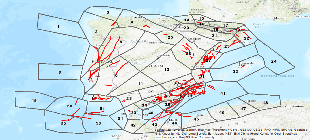
Base de Datos de zonas sismogénicas de la Península Ibérica y territorios de influencia para el cálculo de la peligrosidad
sísmica en España (ZESIS)
Database of seismogenic zones of the Iberian Peninsula and territories of influence for the calculation of seismic hazard
in Spain (ZESIS)
ZESIS es una base de datos de zonas sismogénicas de la Península Ibérica y territorios de influencia desarrollada para el cálculo de la actualización del mapa de peligrosidad sísmica de España (IGN-UPM, 2013). ZESIS es el resultado de la evolución de tres modelos sucesivos en los que han colaborado numerosos investigadores tanto de centros de investigación nacionales como internacionales, y de la sinergia de los proyectos FASEGEO (CGL2009-09726), SHARE (FP7-226967), IBERFAULT (CGL2009-07388), OPPEL (IGN-UPM) y SISMOGEN (IGME-CSIC).
ZESIS is a database of seismogenic zones of the Iberian Peninsula and territories of influence developed for the calculation of the update of the seismic hazard map of Spain (IGN-UPM, 2013). ZESIS is the result of the evolution of three successive models in which numerous researchers from national and international research centres have collaborated, and of the synergy of the FASEGEO (CGL2009-09726), SHARE (FP7-226967), IBERFAULT (CGL2009-07388), OPPEL (IGN-UPM) and SISMOGEN (IGME-CSIC) projects
Simple
-
Título alternativoAlternate title
-
ZESIS
ZESIS
-
Date (Creation)Fecha (Creación)
- 2013-01-01
-
Citation identifierIdentificador del Contacto
- / ESPIGMEZESIS
-
PropósitoPurpose
-
El objetivo principal del ZESIS es identificar una infraestructura de conocimiento sobre la zonas sismogénicas (artificio del cálculo de la peligrosidad sísmica) de la Península Ibérica y territorios de influencia.
The main objective of ZESIS is to identify a knowledge infrastructure about the seismogenic zones (artifice of seismic hazard calculation) of the Iberian Peninsula and territories of influence.
-
CréditoCredit
-
Editores: Julián García-Mayordomo (IGME); Raquel Martín Banda (IGME); María Jesús Mancebo Mancebo (IGME); Cristina Crespo Martín (UCM)
Editors: Julián García-Mayordomo (IGME); Raquel Martín Banda (IGME); María Jesús Mancebo Mancebo (IGME); Cristina Crespo Martín (UCM)
- Point of contact
-
Organisation name Individual name Electronic mail address Role Instituto Geológico y Minero de España (IGME-CSIC)
Geological Survey of Spain (IGME-CSIC)
Julián García-Mayordomo
Julián García-Mayordomo
CustodianGuardián
-
Maintenance and update frequencyMantenimiento y frecuencia de actualización
-
Not plannedSin planificar
-
Tesauro IGME
IGME Thesaurus
-
-
IGME
IGME
-
ZESIS
ZESIS
-
Zonación Sismogénica de Iberia
Seismogenic Zoning of Iberia
-
Zonas Sismogénicas
Seismogenic Zones
-
Peligrosidad sísmica
Seismic hazard
-
QAFI
QAFI
-
Cuaternario
Quaternary
-
Falla
Fault
-
Iberia
Iberia
-
Terremoto
Earthquake
-
Paleosismología
Paleoseismology
-
Tectónica
Tectonics
-
España
Spain
-
Portugal
Portugal
-
- Keywords
-
-
EGDI
EGDI
-
-
Uso específicoSpecific usage
-
ZESIS es una base de datos de zonas sismogénicas de la Península Ibérica y territorios de influencia desarrollada para el cálculo de la actualización del mapa de peligrosidad sísmica de España (IGN-UPM, 2013).
ZESIS is a database of seismogenic zones of the Iberian Peninsula and territories of influence developed for the calculation of the update of the seismic hazard map of Spain (IGN-UPM, 2013).
- User contact info
-
Organisation name Individual name Electronic mail address Role Instituto Geológico y Minero de España (IGME-CSIC)
Geological Survey of Spain (IGME-CSIC)
Point of contactPunto de Contacto
-
Access constraintsRestricciones de Acceso
-
Other restrictionsOtras restricciones
-
Otras limitacionesOther constraints
-
Sin limitaciones al acceso públicoNo Limitations on public access
-
Use constraintsRestricciones de uso
-
Other restrictionsOtras restricciones
-
Otras limitacionesOther constraints
-
LICENCIA DE USO: Condiciones de uso público y difusión de la información para la reutilización de los datos IGME. https://www.igme.es/condiciones-de-uso/
LICENSE OF USE: Conditions of public use and dissemination of information for the reuse of IGME data. https://www.igme.es/condiciones-de-uso/
-
Spatial representation typeTipo de representación espacial
-
VectorVector
-
LanguageIdioma
- Spanish; Castilian
-
Character setCodificación
-
UTF8UTF8
-
Topic categoryCategoría temática
-
-
Geoscientific informationInformación geocientífica
-
))
-
Extent type codeCódigo del tipo de extensión
- Yes
-
Geographic identifierIdentificador geográfico
-
ESES
-
Identificador único del recursoUnique resource identifier
-
EPSG:4326EPSG:4326
-
Identificador único del recursoUnique resource identifier
-
EPSG:4258EPSG:4258
-
Identificador único del recursoUnique resource identifier
-
EPSG:4230EPSG:4230
-
Identificador único del recursoUnique resource identifier
-
EPSG:23028EPSG:23028
-
Identificador único del recursoUnique resource identifier
-
EPSG:23029EPSG:23029
-
Identificador único del recursoUnique resource identifier
-
EPSG:23030EPSG:23030
-
Identificador único del recursoUnique resource identifier
-
EPSG:23031EPSG:23031
-
Identificador único del recursoUnique resource identifier
-
EPSG:25828EPSG:25828
-
Identificador único del recursoUnique resource identifier
-
EPSG:25829EPSG:25829
-
Identificador único del recursoUnique resource identifier
-
EPSG:25830EPSG:25830
-
Identificador único del recursoUnique resource identifier
-
EPSG:25831EPSG:25831
-
Identificador único del recursoUnique resource identifier
-
EPSG:3857EPSG:3857
-
Identificador único del recursoUnique resource identifier
-
EPSG:102100EPSG:102100
- Distribution format
-
Name Version SHP (uso restringido)
No se aplica
Web Map Service WMS
1.3.0
Distributor
Distribuidor
- Distributor contact
-
Organisation name Individual name Electronic mail address Role Instituto Geológico y Minero de España (IGME-CSIC)
Geological Survey of Spain (IGME-CSIC)
DistributorDistribuidor
- Fees
-
Distribución a través de la web
- Distributor format
-
Name Version ShapeFile SHP
ShapeFile - SHP
No se aplica
Joint Photographic Group Format JPEG
Joint Photographic Group Format JPEG
No se aplica
Tagged Image File Format TIFF
Tagged Image File FormatTIFF
No se aplica
Web Map Service WMS
Web Map Service WMS
1.3.0
Distributor
Distribuidor
- Distributor contact
-
Organisation name Individual name Electronic mail address Role Vicedirección Técnica de Sistemas de Información Geológica del Instituto Geológico y Minero del España (IGME-CSIC)
Technical Vice-Directorate of Geological Information Systems of the Geological Survey of Spain (IGME-CSIC)
DistributorDistribuidor
- Distributor format
-
Name Version Servicio web: WMS - Web Map Service
Servicio web: WMS - Web Map Service
1.3.0
- OnLine resource
-
Protocol Linkage Name Servicio de visualización WMS de ZESIS: Base de Datos de Zonas Sismogénicas de la Península Ibérica y territorios de influencia.
http://mapas.igme.es/gis/services/BasesDatos/IGME_ZESIS/MapServer/WmsServer?REQUEST=GetCapabilities&SERVICE=WMS WWW:LINK-1.0-http--link
http://info.igme.es/zesis/ Descarga de ZESIS: Base de Datos de Zonas Sismogénicas de la Península Ibérica y territorios de influencia.
Download ZESIS: Database of Seismogenic Zones of the Iberian Peninsula and territories of influence.
-
Hierarchy levelJerarquía
-
DatasetConjunto de datos
Conformance result
Conformidad del Resultado
-
Date (Publication)Fecha (Publicación)
- 2014-12-31
-
ExplicaciónExplanation
-
Los datos no son conformesNot Conformant
-
PassAprobado
- No
Conformance result
Conformidad del Resultado
-
TítuloTitle
-
Reglamento (CE) No 1205/2008 de la Comisión de 3 de Diciembre de 2008 que estabelece las modalidades de aplicación de la Directiva 2007/2/CE del Parlamento Europeo y del Consejo em materia de metadados
COMMISSION REGULATION (EC) No 1205/2008 of 3 December 2008 implementing Directive 2007/2/EC of the European Parliament and of the Council as regards metadata
-
Date (Publication)Fecha (Publicación)
- 2008-12-04
-
ExplicaciónExplanation
-
Consultar el reglamento
Consult the regulation
-
PassAprobado
- Yes
-
DeclaraciónStatement
-
ZESIS es una base de datos de zonas sismogénicas de la Península Ibérica y territorios de influencia desarrollada para el cálculo de la actualización del mapa de peligrosidad sísmica de España (IGN-UPM, 2013). ZESIS es el resultado de la evolución de tres modelos sucesivos en los que han colaborado numerosos investigadores tanto de centros de investigación nacionales como internacionales, y de la sinergia de los proyectos FASEGEO (CGL2009-09726), SHARE (FP7-226967), IBERFAULT (CGL2009-07388), OPPEL (IGN-UPM) y SISMOGEN (IGME-CSIC).
ZESIS is a database of seismogenic zones of the Iberian Peninsula and territories of influence developed for the calculation of the update of the seismic hazard map of Spain (IGN-UPM, 2013). ZESIS is the result of the evolution of three successive models in which numerous researchers from national and international research centres have collaborated, and of the synergy of the FASEGEO (CGL2009-09726), SHARE (FP7-226967), IBERFAULT (CGL2009-07388), OPPEL (IGN-UPM) and SISMOGEN (IGME-CSIC) projects.
-
DescripciónDescription
-
ZESIS, la base de datos de zonas sismogénicas de la Península Ibérica y territorios de influencia , fue el resultado de la evolución de tres modelos sucesivos en los que han colaborado numerosos investigadores tanto de centros de investigación nacionales como internacionales, y de la sinergia de los proyectos FASEGEO (CGL2009-09726), SHARE (FP7-226967), IBERFAULT (CGL2009-07388), OPPEL (IGN-UPM) y SISMOGEN (IGME-CSIC). .
ZESIS, the database of seismogenic zones of the Iberian Peninsula and territories of influence, was the result of the evolution of three successive models in which numerous researchers from both national and international research centres have collaborated, and of the synergy of the FASEGEO (CGL2009-09726), SHARE (FP7-226967), IBERFAULT (CGL2009-07388), OPPEL (IGN-UPM) and SISMOGEN (IGME-CSIC) projects.
-
TítuloTitle
-
Proyectos FASEGEO (CGL2009-09726), SHARE (FP7-226967), IBERFAULT (CGL2009-07388), OPPEL (IGN-UPM) y SISMOGEN (IGME-CSIC).
Proyectos FASEGEO (CGL2009-09726), SHARE (FP7-226967), IBERFAULT (CGL2009-07388), OPPEL (IGN-UPM) y SISMOGEN (IGME-CSIC).
-
Date (Creation)Fecha (Creación)
- 2013-01-01
- Cited responsible party
-
Organisation name Individual name Electronic mail address Role Instituto Geológico y Minero de España (IGME-CSIC)
Geological Survey of Spain(IGME-CSIC)
Julián García-Mayordomo
Julián García-Mayordomo
OriginatorOrígenInstituto Geológico y Minero de España (IGME-CSIC)
Geological Survey of Spain(IGME-CSIC)
Julián García-Mayordomo
Julián García-Mayordomo
DistributorDistribuidor
-
Presentation formFormulario de presentación
-
Digital documentDocumento digital
Metadata
-
File identifierIdentificador del fichero
- ESPIGMEZESIS20190703 XML
-
Metadata languageIdioma del metadato
- Spanish; Castilian
-
Character setCodificación
-
UTF8UTF8
-
Hierarchy levelJerarquía
-
DatasetConjunto de datos
-
Date stampFecha
- 2025-06-19T12:16:33.18064Z
- Metadata standard name
-
Reglamento (CE) Nº 1205/2008 de Inspire, "Perfil IGME"
- Metadata standard version
-
2.0
- Metadata author
-
Organisation name Individual name Electronic mail address Role Instituto Geológico y Minero de España (IGME-CSIC)
Geological Survey of Spain (IGME-CSIC)
Leticia Vega Martín
Leticia Vega Martín
Point of contactPunto de Contacto
- Other language
-
Language Character encoding EnglishEnglishUTF8UTF8Spanish; CastilianSpanish; CastilianUTF8UTF8
)))