 Catalogo de metadatos IGME-CSIC
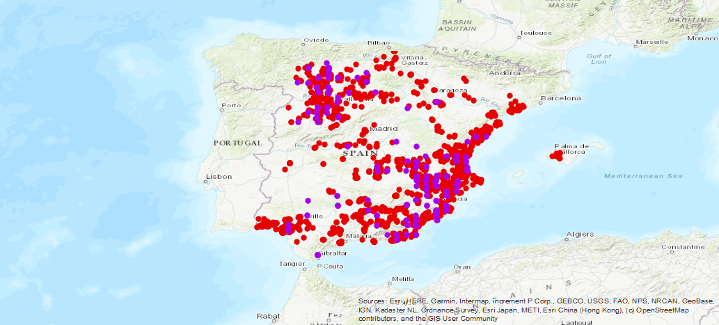
Inventario histórico de los sondeos del IRYDA
IGME Historical inventory of the IRYDA drillings
Datos históricos de los sondeos realizados para la investigación de los diferentes acuíferos de España, resultado de la colaboración entre el Instituto Geológico y Minero de España (IGME-CSIC), con el Instituto Nacional de Reforma y Desarrollo Agrario (IRYDA), antes Instituto Nacional de Colonización (INC). Los sondeos fueron realizados fundamentalmente entre 1950 y 1990.
Historical data of the surveys carried out for the investigation of the different aquifers of Spain, the result of the collaboration between the Geological and Mining Institute of Spain (IGME-CSIC), with the National Institute of Agrarian Reform and Development (IRYDA), before the National Institute of Colonization (INC). The surveys were conducted mainly between 1950 and 1990
Simple
-
Título alternativoAlternate title
-
Sondeos IRYDA
IRYDA Boreholes
-
Date (Creation)Fecha (Creación)
- 1990-01-01
-
Citation identifierIdentificador del Contacto
- IGME-CSIC / ESPIGME_BD_SONDEOSIRYDA
-
PropósitoPurpose
-
La Base de Datos de Sondeos IRYDA se creó con el objetivo de cubrir fundamentalemnte la necesidad del almacenamiento sencillo y rápido del volumen de datos obtenidos dentro de la colaboración entre el IGME e IRYDA, en relación al conocimiento de los acuíferos subterráneos de España, su potencial hidráulico , fundamentalmente a partir de los Planes de Investigación de Aguas Subterráneas (PIAS) y de Gestión y Conservación de Acuíferos (PGCA) y Abastecimiento a Núcleos Urbanos (PANU).
The IRYDA Survey Database was created with the objective of fundamentally covering the need for simple and fast storage of the volume of data obtained within the collaboration between the IGME and IRYDA, in relation to the knowledge of the underground aquifers of Spain, their potential Hydraulic, mainly from the Underground Water Research Plans (PIAS) and Aquifer Management and Conservation (PGCA) and Urban Nucleus Supply (PANU).
- Point of contact
-
Organisation name Individual name Electronic mail address Role Instituto Geológico y Minero de España (IGME-CSIC)
Geological Survey of Spain (IGME-CSIC)
Miguel Mejías Moreno
Point of contactPunto de Contacto
-
Maintenance and update frequencyMantenimiento y frecuencia de actualización
-
Not plannedSin planificar
- Keywords
-
-
IRYDA
IRYDA
-
INC
INC
-
-
Tesauro IGME
IGME Thesaurus
-
-
IGME
IGME
-
AGUAS
WATER
-
Puntos de Agua
Water Points
-
Sondeo
Borehole
-
Hidrogeología
Hydroeology
-
Litología
lithology
-
España
Spain
-
- Keywords
-
-
EGDI
EGDI
-
-
Uso específicoSpecific usage
-
Esta base recopila y facilita la utilización de estos datos evitándose la pérdida de información almacenando en una única ubicación los datos de los parámetros geográfico-administrativos, técnicos, hidrogeológicos e hidroquímicos, obtenidos a lo largo del tiempo en todos los estudios e investigaciones de las diferentes cuencas hidrográficas llevadas a cabo en el IGME. Asimismo facilitala consulta de esta información a los diferentes Organismos de la administración tanto central como Autonómica, empresas privadas y particulares.
This mechanized file facilitates the selective access and use of these data avoiding the loss of information by storing in a single location the data of the geographic-administrative, technical, hydrogeological and hydrochemical parameters, obtained over time in all studies and research of the different river basins carried out in the IGME. It also facilitates the consultation of this information to the different central and regional administration agencies, private companies and individuals.
- User contact info
-
Organisation name Individual name Electronic mail address Role Instituto Geológico y Minero de España (IGME-CSIC).
Geological Survey of Spain (IGME-CSIC).
Point of contactPunto de Contacto
-
Access constraintsRestricciones de Acceso
-
Other restrictionsOtras restricciones
-
Otras limitacionesOther constraints
-
Sin limitaciones al acceso público.No Limitations
-
Use constraintsRestricciones de uso
-
Other restrictionsOtras restricciones
-
Otras limitacionesOther constraints
-
LICENCIA DE USO: Condiciones de uso público y difusión de la información para la reutilización de los datos IGME. https://www.igme.es/condiciones-de-uso/
LICENSE OF USE: Conditions of public use and dissemination of information for the reuse of IGME data. https://www.igme.es/condiciones-de-uso/
-
Spatial representation typeTipo de representación espacial
-
VectorVector
-
LanguageIdioma
- Spanish; Castilian
-
Character setCodificación
-
UTF8UTF8
-
Topic categoryCategoría temática
-
-
Geoscientific informationInformación geocientífica
-
))
-
Extent type codeCódigo del tipo de extensión
- Yes
-
Geographic identifierIdentificador geográfico
-
ESES
-
Identificador único del recursoUnique resource identifier
-
EPSG:4326EPSG:4326
-
Identificador único del recursoUnique resource identifier
-
EPSG:4258EPSG:4258
-
Identificador único del recursoUnique resource identifier
-
EPSG:4230EPSG:4230
-
Identificador único del recursoUnique resource identifier
-
EPSG:23028EPSG:23028
-
Identificador único del recursoUnique resource identifier
-
EPSG:23029EPSG:23029
-
Identificador único del recursoUnique resource identifier
-
EPSG:23030EPSG:23030
-
Identificador único del recursoUnique resource identifier
-
EPSG:23031EPSG:23031
-
Identificador único del recursoUnique resource identifier
-
EPSG:25828EPSG:25828
-
Identificador único del recursoUnique resource identifier
-
EPSG:25829EPSG:25829
-
Identificador único del recursoUnique resource identifier
-
EPSG:25830EPSG:25830
-
Identificador único del recursoUnique resource identifier
-
EPSG:25831EPSG:25831
-
Identificador único del recursoUnique resource identifier
-
EPSG:3857EPSG:3857
-
Identificador único del recursoUnique resource identifier
-
EPSG:102100EPSG:102100
- Distribution format
-
Name Version SHP (uso restringido)
No se aplica
Web Map Service WMS
1.3.0
Distributor
Distribuidor
- Distributor contact
-
Organisation name Individual name Electronic mail address Role Instituto Geológico y Minero de España (IGME-CSIC)
Geological Survey of Spain (IGME-CSIC)
DistributorDistribuidor
- Fees
-
Distribución a través de la web
- Distributor format
-
Name Version ShapeFile SHP
ShapeFile SHP
No se aplica
Joint Photographic Group Format JPEG
Joint Photographic Group Format JPEG
No se aplica
Tagged Image File Format TIFF
Tagged Image File Format TIFF
No se aplica
Web Map Service WMS
Web Map Service WMS
1.3.0
Distributor
Distribuidor
- Distributor contact
-
Organisation name Individual name Electronic mail address Role Vicedirección Técnica. Instituto Geológico y Minero de España (IGME-CSIC)
Area of Geological Information Systems of the Geological Survey of Spain (IGME-CSIC)
DistributorDistribuidor
- Distributor format
-
Name Version Servicio web: WMS - Web Map Service
Servicio web: WMS - Web Map Service
1.3.0
- OnLine resource
-
Protocol Linkage Name Servicio de visualización WMS del Inventario de sondeos históricos del IRYDA.
http://mapas.igme.es/gis/services/BasesDatos/IGME_SondeosIRYDA/MapServer/WMSServer?REQUEST=GetCapabilities&SERVICE=WMS WWW:LINK-1.0-http--link
http://info.igme.es/visor/ Visualización del Inventario de sondeos históricos del IRYDA
Visualization of Historical inventory of the IRYDA drillings
-
Hierarchy levelJerarquía
-
DatasetConjunto de datos
Conformance result
Conformidad del Resultado
-
Date (Publication)Fecha (Publicación)
- 2014-12-31
-
ExplicaciónExplanation
-
Los datos no son conformesNot Conformant
-
PassAprobado
- No
Conformance result
Conformidad del Resultado
-
TítuloTitle
-
Reglamento (CE) No 1205/2008 de la Comisión de 3 de Diciembre de 2008 que estabelece las modalidades de aplicación de la Directiva 2007/2/CE del Parlamento Europeo y del Consejo em materia de metadados
COMMISSION REGULATION (EC) No 1205/2008 of 3 December 2008 implementing Directive 2007/2/EC of the European Parliament and of the Council as regards metadata
-
Date (Publication)Fecha (Publicación)
- 2008-12-04
-
ExplicaciónExplanation
-
Consultar el reglamento mencionado
Consult the regulations
-
PassAprobado
- Yes
-
DeclaraciónStatement
-
Datos históricos de los sondeos realizados para la investigación de los diferentes acuíferos de España, resultado de la colaboración entre el Instituto Geológico y Minero de España (IGME-CSIC), con el Instituto Nacional de Reforma y Desarrollo Agrario (IRYDA), antes Instituto Nacional de Colonización (INC). Los sondeos fueron realizados fundamentalmente entre 1950 y 1990. La Base de Datos de Sondeos IRYDA se creó con el objetivo de cubrir fundamentalemnte la necesidad del almacenamiento sencillo y rápido del volumen de datos obtenidos dentro de la colaboración entre el IGME e IRYDA, en relación al conocimiento de los acuíferos subterráneos de España, su potencial hidráulico , fundamentalmente a partir de los Planes de Investigación de Aguas Subterráneas (PIAS) y de Gestión y Conservación de Acuíferos (PGCA) y Abastecimiento a Núcleos Urbanos (PANU).
Historical data from soundings carried out for the investigation of the different aquifers in Spain, the result of collaboration between the Geological and Mining Institute of Spain (IGME-CSIC), with the National Institute of Agrarian Reform and Development (IRYDA), formerly the National Institute of Colonization (INC). Surveys were carried out mainly between 1950 and 1990. The IRYDA Drilling Database was created with the aim of covering the need for simple and rapid storage of the volume of data obtained within the collaboration between the IGME and IRYDA, in relation to the knowledge of underground aquifers in Spain, their hydraulic potential, mainly from the Research Plans for Groundwater (PIAS) and Aquifer Management and Conservation (PGCA) and Supply to Urban Nuclei (PANU)..
-
DescripciónDescription
-
Fundamentalmente las principales fuentes de información fueron los Planes de Investigación de Aguas Subterráneas (PIAS) y de Gestión y Conservación de Acuíferos (PGCA) y Abastecimiento a Núcleos Urbanos (PANU)
The main sources of information were the Groundwater Research Plan (PIAS) and the Aquifer Management and Conservation Plan (PGCA) and the Urban Core Supply Plan (PANU).
-
TítuloTitle
-
Inventario histórico de los sondeos del IRYDA
Historical inventory of the IRYDA drillings
-
Date (Creation)Fecha (Creación)
- 1970-01-01
- Cited responsible party
-
Organisation name Individual name Electronic mail address Role Instituto Geológico y Minero de España (IGME-CSIC)
Geological Survey of Spain (IGME-CSIC)
Miguel Mejías Moreno
Mejías Moreno, Miguel
Point of contactPunto de ContactoInstituto Geológico y Minero de España (IGME-CSIC)
Geological Survey of Spain(IGME-CSIC)
Miguel Mejías Moreno
Mejías Moreno, Miguel
DistributorDistribuidor
-
Presentation formFormulario de presentación
-
Digital documentDocumento digital
Metadata
-
File identifierIdentificador del fichero
- ESPIGMESONDEOSIRYDA20190726 XML
-
Metadata languageIdioma del metadato
- Spanish; Castilian
-
Character setCodificación
-
UTF8UTF8
-
Hierarchy levelJerarquía
-
DatasetConjunto de datos
-
Date stampFecha
- 2025-06-19T12:42:21.853469Z
- Metadata standard name
-
Reglamento (CE) Nº 1205/2008 de Inspire, "Perfil IGME"
- Metadata standard version
-
2.0
- Metadata author
-
Organisation name Individual name Electronic mail address Role Instituto Geológico y Minero de España (IGME-CSIC)
Geological Survey of Spain (IGME-CSIC)
Leticia Vega Martín
Leticia Vega Mártín
Point of contactPunto de Contacto
- Other language
-
Language Character encoding EnglishEnglishUTF8UTF8Spanish; CastilianSpanish; CastilianUTF8UTF8
)))