 Catalogo de metadatos IGME-CSIC
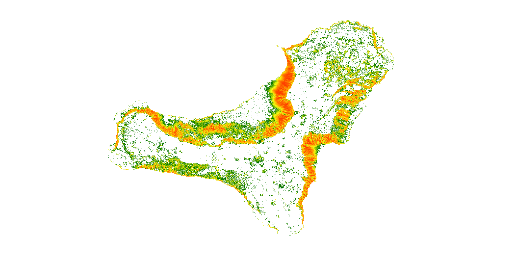
Web Service of Map of rockfall trajectories simulation in the island of El Hierro (Canary Islands)
The map show the number of trajectories that pass through each pixel
Simple
Identification info
- Date (Publication)
- 2019-10-28
- Citation identifier
- IGME-CSIC / WMS_UGEOHAZ_ROCKFALLTRAJECTORIESELHIERRO
- Purpose
-
The data may be used as input to calculate rockfalls risk on the island of El Hierro (Canary Islands), and to estimate the potential economic losses
- Point of contact
-
Organisation name Individual name Electronic mail address Role Geological Survey of Spain (IGME-CSIC)
Point of contact Geological Survey of Spain (IGME-CSIC)
Custodian
-
IGME Thesaurus
-
-
Rockfalls
-
Trajectory
-
Risk
-
Hazard
-
Volcanic environment
-
Canary Islands
-
IGME
-
- Keywords
-
-
EGDI
-
-
ISO - 19119 geographic services taxonomy
-
-
infoMapAccessService
-
-
INSPIRE_SpatialDataServicesClassification
-
-
Map Access Service
-
Geographic model/information management service
-
-
Web Services Specifications
-
-
WMS (Web Map Service)
-
WMS 1.3.0
-
WMS 1.3.0
-
- Access constraints
- Other restrictions
- Other constraints
- No limitations to public access.
- Use constraints
- Other restrictions
- Other constraints
-
LICENSE FOR USE: Conditions governing the public use and dissemination of the information for the re-use of the IGME data. https://www.igme.es/condiciones-de-uso/
- Service Type
- view
))
- Coupling Type
- Tight
- Contains Operations
-
Operation Name Distributed Computing Platforms Connect Point GetCapabilities
Web services http://mapas.igme.es/gis/services/UGeoHaz/UGEOHAZ_ROCKFALLTRAJECTORIES_ELHIERRO/MapServer/WMSServer GetMap
Web services http://mapas.igme.es/gis/services/UGeoHaz/UGEOHAZ_ROCKFALLTRAJECTORIES_ELHIERRO/MapServer/WMSServer GetFeatureInfo
Web services http://mapas.igme.es/gis/services/UGeoHaz/UGEOHAZ_ROCKFALLTRAJECTORIES_ELHIERRO/MapServer/WMSServer
- Unique resource identifier
- EPSG:4258
- Unique resource identifier
- EPSG:32628
- Distribution format
-
- OnLine resource
-
Protocol Linkage Name OGC:WMS-1.3.0-http-get-capabilities
http://mapas.igme.es/gis/services/UGeoHaz/UGEOHAZ_ROCKFALLTRAJECTORIES_ELHIERRO/MapServer/WMSServer?request=GetCapabilities&Service=WMS&Version=1.3.0 Web Service of Map of rockfall trajectories simulation in the island of El Hierro (Canary Islands)
- Hierarchy level
- Service
- Other
-
Servicio de visualización
Conformance result
- Date (Publication)
- 2009-10-19
- Explanation
-
See the above-mentioned regulation
- Pass
- No
Conformance result
- Title
-
Commission Regulation (EU) No 1089/2010 of 23 November 2010 implementing Directive 2007/2/EC of the European Parliament and of the Council as regards the interoperability of spatial data sets and services
- Date (Publication)
- 2010-12-08
- Explanation
-
See the above-mentioned regulation
- Pass
- No
Conformance result
- Title
-
COMMISSION REGULATION (EC) No 1205/2008 of 3 December 2008 implementing Directive 2007/2/EC of the European Parliament and of the Council as regards metadata
- Date (Publication)
- 2008-12-04
Citation identifier
- Explanation
-
See the above-mentioned regulation
- Pass
- Yes
Metadata
- File identifier
- ESPIGMESERVICIOROCKFALLSTRAJECTORIESELHIERRO20191031 XML
- Metadata language
- Spanish; Castilian
- Character set
- UTF8
- Hierarchy level
- Service
- Hierarchy level name
-
Servicio
- Date stamp
- 2025-05-30T08:16:35.779688Z
- Metadata standard name
-
Reglamento (CE) Nº 1205/2008 de Inspire, "Perfil IGME"
- Metadata standard version
-
2.0
- Metadata author
-
Organisation name Individual name Electronic mail address Role Geological Survey of Spain (IGME-CSIC)
Leticia Vega Martín
Point of contact
- Other language
-
Language Character encoding English UTF8 Spanish; Castilian UTF8
)))