 Catalogo de metadatos IGME-CSIC
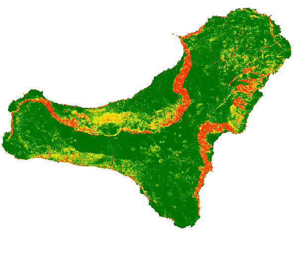
Web Service of Map of rockfall source areas, El Hierro (Canary Islands, Spain)
The map shows a probabilistic identification of rockfall source areas for El Hierro Island, prepared with the combination of multiple statistical models
Simple
Identification info
- Date (Publication)
- 2019-10-28
- Citation identifier
- IGME-CSIC / WMS_UGEOHAZ_ROCKFALLSOURCEAREAELHIERRO
- Purpose
-
The map shows on line the probability of each single pixel to be a rock fall source area and can be used as input for rockfall regional modelling in El Hierro (Canary Island)
- Point of contact
-
Organisation name Individual name Electronic mail address Role Geological Survey of Spain (IGME-CSIC)
Point of contact Geological Survey of Spain (IGME-CSIC)
Custodian
-
IGME Thesaurus
-
-
Rockfalls
-
Trajectory
-
Risk
-
Hazard
-
Volcanic environment
-
Canary Islands
-
IGME
-
- Keywords
-
-
EGDI
-
-
ISO - 19119 geographic services taxonomy
-
-
infoMapAccessService
-
-
INSPIRE_SpatialDataServicesClassification
-
-
Map Access Service
-
Geographic model/information management service
-
-
Web Services Specifications
-
-
WMS (Web Map Service)
-
WMS 1.3.0
-
WMS
-
- Access constraints
- Other restrictions
- Other constraints
- No limitations to public access.
- Use constraints
- Other restrictions
- Other constraints
-
LICENSE FOR USE: Conditions governing the public use and dissemination of the information for the re-use of the IGME data. https://www.igme.es/condiciones-de-uso/
- Service Type
- view
))
- Coupling Type
- Tight
- Contains Operations
-
Operation Name Distributed Computing Platforms Connect Point GetCapabilities
Web services http://mapas.igme.es/gis/services/UGeoHaz/UGEOHAZ_ROCKFALLSOURCEAREAS_ELHIERRO/MapServer/WMSServer GetMap
Web services http://mapas.igme.es/gis/services/UGeoHaz/UGEOHAZ_ROCKFALLSOURCEAREAS_ELHIERRO/MapServer/WMSServer GetFeatureInfo
Web services http://mapas.igme.es/gis/services/UGeoHaz/UGEOHAZ_ROCKFALLSOURCEAREAS_ELHIERRO/MapServer/WMSServer
- Unique resource identifier
- EPSG:4258
- Unique resource identifier
- EPSG:32628
- Distribution format
-
- OnLine resource
-
Protocol Linkage Name OGC:WMS-1.3.0-http-get-capabilities
http://mapas.igme.es/gis/services/UGeoHaz/UGEOHAZ_ROCKFALLSOURCEAREAS_ELHIERRO/MapServer/WMSServer?request=GetCapabilities&Service=WMS&Version=1.3.0 Rockfall Map Web Service, El Hierro (Canary Islands, Spain)
- Hierarchy level
- Service
- Other
-
Servicio de visualización
Conformance result
- Date (Publication)
- 2009-10-19
- Explanation
-
See the above-mentioned regulation
- Pass
- No
Conformance result
- Title
-
Commission Regulation (EU) No 1089/2010 of 23 November 2010 implementing Directive 2007/2/EC of the European Parliament and of the Council as regards the interoperability of spatial data sets and services
- Date (Publication)
- 2010-12-08
- Explanation
-
See the above-mentioned regulation
- Pass
- No
Conformance result
- Title
-
COMMISSION REGULATION (EC) No 1205/2008 of 3 December 2008 implementing Directive 2007/2/EC of the European Parliament and of the Council as regards metadata
- Date (Publication)
- 2008-12-04
Citation identifier
- Explanation
-
See the above-mentioned regulation
- Pass
- Yes
Metadata
- File identifier
- ESPIGMESERVICIOROCKFALLSOURCEAREASELHIERRO20191031 XML
- Metadata language
- Spanish; Castilian
- Character set
- UTF8
- Hierarchy level
- Service
- Hierarchy level name
-
Servicio
- Date stamp
- 2025-05-30T08:08:22.389383Z
- Metadata standard name
-
Reglamento (CE) Nº 1205/2008 de Inspire, "Perfil IGME"
- Metadata standard version
-
2.0
- Metadata author
-
Organisation name Individual name Electronic mail address Role Geological Survey of Spain (IGME-CSIC)
Leticia Vega Martín
Point of contact
- Other language
-
Language Character encoding English UTF8 Spanish; Castilian UTF8
)))