 Catalogo de metadatos IGME-CSIC
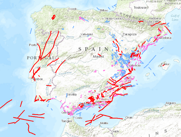
Visualisation service (WMS) of the Quaternary Fault Database of the iberian peninsula (QAFI).
Visualisation service of QAFI, a database of faults with geological evidence of proven activity during the Quaternary period (the last 2.6 million years according to the limit officially established by the SQS in 2009) of the iberian peninsula. It is a project in constant revision and updating as a result of the progress of studies and knowledge about the structures capable of generating earthquakes in Iberia, and can never be considered complete or definitive, both because of the scientific nature of the data contained in it, and because of the modus operandi used in its construction: the altruistic collaboration of numerous researchers in Earth Sciences.
Simple
Identification info
- Date (Publication)
- 2012-02-07
- Citation identifier
- IGME_CSIC / WMS_BD_QAFI
- Status
- Completed
- Point of contact
-
Organisation name Individual name Electronic mail address Role Geological Survey of Spain (IGME-CSIC)
Point of contact Geological Survey of Spain (IGME-CSIC)
Custodian
- Keywords
-
-
IGME
-
Iberia
-
Palaeoseismology
-
Tectonics
-
Sismic Hazard
-
WMS
-
-
IGME Thesaurus
-
-
Quaternary
-
Fault
-
-
GEMET - INSPIRE themes, version 1.0
- Keywords
-
-
Earthquakes
-
Seismic Hazards
-
Natural risk zones
-
-
CEOLocation
-
-
COUNTRIES
-
SPAIN
-
PORTUGAL
-
-
EuropeanTerritorialUnits
-
-
SPAIN
-
- Keywords
-
-
Iberia
-
- Keywords
-
-
EGDI
-
- Access constraints
- Other restrictions
- Other constraints
- No limitations on public access.
- Use constraints
- Other restrictions
- Other constraints
-
LICENCE OF USE: Conditions of public use and dissemination of information for the re-use of IGME data. https://www.igme.es/condiciones-de-uso/
- Service Type
- view
))
- Coupling Type
- Ajustado
- Contains Operations
-
Operation Name Distributed Computing Platforms Connect Point GetCapabilities
Web services http://mapas.igme.es/gis/services/BasesDatos/IGME_QAFI/MapServer/WMSServer GetMap
Web services http://mapas.igme.es/gis/services/BasesDatos/IGME_QAFI/MapServer/WMSServer GetFeatureInfo
Web services http://mapas.igme.es/gis/services/BasesDatos/IGME_QAFI/MapServer/WMSServer
- Title
-
European Petroleum Surgey Group
- Date (Creation)
- 1986-01-01
- Distribution format
-
- OnLine resource
-
Protocol Linkage Name OGC:WMS-1.3.0-http-get-capabilities
http://mapas.igme.es/gis/services/BasesDatos/IGME_QAFI/MapServer/WMSServer?Request=GetCapabilities&Service=WMS&Version=1.3.0 Link to the GetCapabilities of the web service hosting the product
- Hierarchy level
- Service
- Other
-
Servicio web de datos espaciales. Servicio de visualización
Conformance result
- Date (Publication)
- 2009-10-19
- Explanation
-
Consult the regulation mentioned
- Pass
- No
Conformance result
Conformance result
- Title
-
REGLAMENTO (CE) No 1205/2008 DE LA COMISIÓN de 3 de diciembre de 2008 por el que se ejecuta la Directiva 2007/2/CE del Parlamento Europeo y del Consejo en lo que se refiere a los metadatos
- Date (Publication)
- 2008-12-03
- Explanation
-
Consult the regulation mentioned
- Pass
- Yes
Metadata
- File identifier
- ESPIGMESERVICIOQAFI20120312 XML
- Metadata language
- Spanish; Castilian
- Hierarchy level
- Service
- Hierarchy level name
-
Servicio
- Date stamp
- 2025-06-02T15:07:53.186619Z
- Metadata standard name
-
Reglamento (CE) Nº 1205/2008 de Inspire, "Perfil IGME"
- Metadata standard version
-
2.0
- Metadata author
-
Organisation name Individual name Electronic mail address Role Geological Survey of Spain (IGME-CSIC)
Leticia Vega Martín
Point of contact
- Other language
-
Language Character encoding English UTF8 Spanish; Castilian UTF8
)))