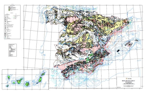
Neotectonic Map of Spain at a scale of 1:1,000,000
El Mapa Neotectónico expresa aquellos rasgos estructurales, morfológicos, estratigráficos y de todo tipo, que ponen en evidencia movimientos relativamente recientes (de la época que se ha considerado neotectónica), así como el tipo de esfuerzo al que está sometida la península. Sus objetivos son la identificación de las deformaciones desde el límite Mioceno Medio - Mioceno Superior hasta la actualidad. Los materiales se han clasificado en seis categorías, dos para materiales volcánicos diferenciados por edad; y cuatro para el resto de materiales, con cuatro subdivisiones en función de la edad. También comprende estructuras tectónicas, direcciones de esfuerzo y deformación, estructuras diapíricas y otros fenómenos relacionados, todos con expresión de su edad. El mapa contiene información de la plataforma continental española.
The Neotectonic Map expresses those structural, morphological, stratigraphic and other features that show relatively recent movements (from the period considered neotectonic), as well as the type of stress to which the peninsula is subjected. Its objectives are to identify deformations from the Middle Miocene - Upper Miocene boundary to the present day. The materials have been classified into six categories, two for volcanic materials differentiated by age; and four for the rest of the materials, with four subdivisions according to age. It also includes tectonic structures, stress and deformation directions, diapiric structures and other related phenomena, all with age expression. The map contains information on the Spanish continental shelf.
Simple
Identification info
- Date (Publication)
- 2010-08-16
- Status
- Completed
-
GEMET - INSPIRE themes, version 1.0
GEMET - INSPIRE themes, version 1.0
-
-
Geología
Geology
-
- Keywords
-
-
IGME
IGME
-
IDEE
IDEE
-
Neotectonico
Neotectonic
-
España
Spain
-
- Keywords
-
-
EGDI
EGDI
-
-
INSPIRE_SpatialDataServicesClassification
INSPIRE_SpatialDataServicesClassification
-
-
Servicio de acceso a mapas
Map access service
-
infoMapAccessService
infoMapAccessService
-
Servicio de gestión de modelos/información geográficos
Geographic modelling/information management service
-
infoManagementService
infoManagementService
-
-
Especificaciones de Servicios Web
Web Services Specifications
-
-
OGC (Open Geospatial Consortium)
OGC (Open Geospatial Consortium)
-
WMS (Web Map Service)
WMS (Web Map Service)
-
WMS 1.3.0
WMS 1.3.0
-
OGC
OGC
-
WMS
WMS
-
- Access constraints
- Other restrictions
- Other constraints
- No limitations on public access.
- Use constraints
- Other restrictions
- Other constraints
-
LICENCIA DE USO: Condiciones de uso público y difusión de la información para la reutilización de los datos IGME http://www.igme.es/Ayuda/CondiUso.htm
LICENCE OF USE: Conditions of public use and dissemination of information for the re-use of IGME data. http://www.igme.es/Ayuda/CondiUso.htm
- Use constraints
- Other restrictions
- Service Type
- view
))
- Coupling Type
- Ajustado
Contains Operations
- Operation Name
-
GetCapabilities
- Distributed Computing Platforms
- Web services
- Connect Point
- URL de acceso ( OGC Web Map Service )
Contains Operations
- Operation Name
-
GetMap
- Distributed Computing Platforms
- Web services
- Connect Point
- URL de acceso ( OGC Web Map Service )
Contains Operations
- Operation Name
-
GetFeatureInfo
- Distributed Computing Platforms
- Web services
- Connect Point
- URL de acceso ( OGC Web Map Service )
- Operates On
- Distribution format
-
- OnLine resource
- Link to GetCapabilities of the web service hosting the product ( OGC:WMS-1.3.0-http-get-capabilities )
- Hierarchy level
- Service
- Other
-
Servicio de visualización
Conformance result
- Date (Publication)
- 2009-10-19
- Explanation
-
Consultar el reglamento mencionado
Consult the regulation mentioned above
- Pass
- No
Conformance result
- Date (Publication)
- 2010-12-08
- Explanation
-
Consultar el reglamento
Consult the regulations
- Pass
- No
Conformance result
- Date (Publication)
- 2008-12-04
Identifier
- Explanation
-
Consultar el reglamento mencionado
Consult the regulations
- Pass
- Yes
- File identifier
- ESPIGMESERVICIONEOTECTONICO100020120404 XML
- Metadata language
- Spanish; Castilian
- Character set
- UTF8
- Hierarchy level
- Service
- Hierarchy level name
-
Servicio
- Date stamp
- 2022-06-29T11:14:11
- Metadata standard name
-
Reglamento (CE) Nº 1205/2008 de Inspire, "Perfil IGME"
- Metadata standard version
-
2.0
http://www.igme.es
Overviews

Spatial extent
))
Provided by

 Catalogo de metadatos del IGME