 Catalogo de metadatos IGME-CSIC
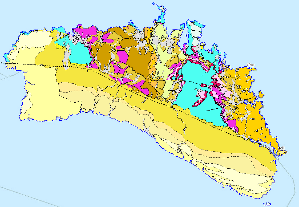
Visualisation service (WMS) of the Geological Map of Menorca 1:100.000
Map showing the chronolithostratigraphic units of the area covered by the sheet separated by different types of contacts: normal or concordant, discordant and mechanical or intrusive. The tectonic structure is represented by the cartographic traces of the folds, the orientation and dip of the planar and linear elements contained in the rocks, as well as by the structural relationship -by means of faults and thrusts- between the rock assemblages differentiated cartographically.
Simple
Identification info
- Date (Publication)
- 2009-03-01
- Status
- Completed
- Point of contact
-
Organisation name Individual name Electronic mail address Role Geological Survey of Spain (IGME-CSIC)
Point of contact Geological Survey of Spain (IGME-CSIC)
Custodian
-
IGME Thesaurus
-
-
General geology
-
General geology.geology
-
General geology.lithology
-
Structural geology.fault
-
General geology.rock
-
Stratigraphy
-
Chronostratigraphy
-
RocK
-
Sedimentary rock
-
Crystalline rock
-
Igneous rock
-
Quaternary Geomorphology and Geology
-
Surface formation
-
Structural geology
-
Folding
-
Stratigraphy Systematics
-
Mesozoic
-
Triassic
-
Jurassic
-
Cretaceous
-
Neogene
-
Quaternary
-
-
INSPIRE_SpatialDataServicesClassification
-
-
Map access service
-
infoMapAccessService
-
Geographic modelling/information management service
-
infoManagementService
-
-
CEOLocation
-
-
COUNTRIES
-
SPAIN
-
- Keywords
-
-
Islas Baleares
-
Menorca
-
IGME
-
IDEE
-
-
EuropeanTerritorialUnits
-
-
ESPAÑA
-
lles Balears
-
-
Web Services Specifications
-
-
OGC (Open Geospatial Consortium)
-
WMS (Web Map Service)
-
WMS 1.3.0
-
OGC
-
WMS
-
- Access constraints
- Other restrictions
- Other constraints
- No limitations on public access
- Use constraints
- Other restrictions
- Other constraints
-
LICENCE OF USE: Conditions of public use and dissemination of information for the re-use of IGME data http://www.igme.es/Ayuda/CondiUso.htm
- Service Type
- view
))
- Coupling Type
- Tight
- Contains Operations
-
Operation Name Distributed Computing Platforms Connect Point GetCapabilities
Web services http://mapas.igme.es/gis/services/Cartografia_Geologica/IGME_GeologicoMenorca_100/MapServer/WMSServer GetMap
Web services http://mapas.igme.es/gis/services/Cartografia_Geologica/IGME_GeologicoMenorca_100/MapServer/WMSServer GetFeatureInfo
Web services http://mapas.igme.es/gis/services/Cartografia_Geologica/IGME_GeologicoMenorca_100/MapServer/WMSServer
- Operates On
- Unique resource identifier
- EPSG:6230
- Unique resource identifier
- EPSG:23031
- Distribution format
-
- OnLine resource
-
Protocol Linkage Name OGC:WMS-1.3.0-http-get-capabilities
http://mapas.igme.es/gis/services/Cartografia_Geologica/IGME_GeologicoMenorca_100/MapServer/WMSServer?Request=GetCapabilities&Service=WMS Link to the GetCapabilities of the web service hosting the product
- Hierarchy level
- Service
- Other
-
Servicio de visualización
Conformance result
- Date (Publication)
- 2009-10-19
- Explanation
-
Consult the above-mentioned regulation
- Pass
- No
Conformance result
- Title
-
Reglamento (UE) n o 1089/2010 de la Comisión de 23 de noviembre de 2010 por el que se aplica la Directiva 2007/2/CE del Parlamento Europeo y del Consejo en lo que se refiere a la interoperabilidad de los conjuntos y los servicios de datos espaciales
- Date (Publication)
- 2010-12-08
- Explanation
-
Consult the above-mentioned regulation
- Pass
- No
Metadata
- File identifier
- ESPIGMESERVICIOGEOMENORCA1002011022190100 XML
- Metadata language
- Spanish; Castilian
- Hierarchy level
- Service
- Hierarchy level name
-
Servicio
- Date stamp
- 2025-05-12T10:41:53.7884Z
- Metadata standard name
-
Reglamento (CE) Nº 1205/2008 de Inspire, "Perfil IGME"
- Metadata standard version
-
TG 2.0
- Metadata author
-
Organisation name Individual name Electronic mail address Role Geological Survey of Spain (IGME-CSIC)
Leticia Vega Martín
Point of contact
- Other language
-
Language Character encoding English UTF8 Spanish; Castilian UTF8
)))