 Catalogo de metadatos IGME-CSIC
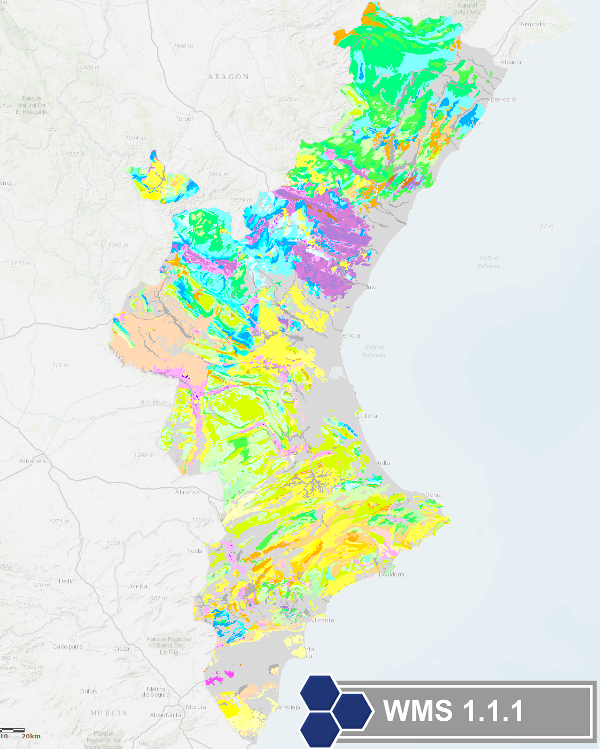
WMS Service of Geological Map of Valencian Comunity at scale 1:400,000
Map with the chronolithostratigraphic units of the Valencian Community, including faults and fold structures. It is a unified geological synthesis based on maps from the Spanish Geological Survey (IGME) of this territory at scales of 1:200,000 and 1:50,000.
Simple
Identification info
- Date (Creation)
- 2009-03-01
- Date (Publication)
- 2009-03-01
- Citation identifier
- IGME-CSIC / WMS_GEOCOMUNIDADVALENCIANA400
- Point of contact
-
Organisation name Individual name Electronic mail address Role Geological Survey of Spain (IGME-CSIC)
Point of contact Geological Survey of Spain (IGME-CSIC)
Custodian
-
CEOLocation
-
-
COUNTRIES
-
Spain
-
-
EuropeanTerritorialUnits
-
-
SPAIN
-
Comunitat Valenciana / Comunidad Valenciana
-
Valencia/Valéncia
-
Alicante/Alacant
-
Castellón/Castelló
-
- Keywords
-
-
IGME
-
IDEE
-
-
INSPIRE_SpatialDataServicesClassification
-
-
Map access service
-
infoMapAccessService
-
Geographic modelling/information management service
-
infoManagementService
-
-
Web Services Specification
-
-
OGC (Open Geospatial Consortium)
-
WMS (Web Map Service)
-
WMS 1.3.0
-
OGC
-
WMS
-
- Access constraints
- Other restrictions
- Other constraints
- Mo limitations on public access
- Use constraints
- Other restrictions
- Other constraints
-
LICENCE OF USE: Conditions of public use and dissemination of information for the re-use of IGME data. https://www.igme.es/condiciones-de-uso/
- Service Type
- view
))
- Coupling Type
- Tight
- Contains Operations
-
Operation Name Distributed Computing Platforms Connect Point GetCapabilities
Web services https://mapas.igme.es/gis/services/Cartografia_Geologica/IGME_GeologicoCValenciana_400MapServer/WMSServer?request=getcapabilities&service=wms&version=1.3.0 GetMap
Web services https://mapas.igme.es/gis/services/Cartografia_Geologica/IGME_GeologicoCValenciana_400/MapServer/WMSServer?request=getcapabilities&service=wms&version=1.3.0 GetFeatureInfo
Web services https://mapas.igme.es/gis/services/Cartografia_Geologica/IGME_GeologicoCValenciana_400/MapServer/WMSServer
- Distribution format
-
- OnLine resource
-
Protocol Linkage Name OGC:WMS-1.3.0-http-get-capabilities
http://mapas.igme.es/gis/services/Cartografia_Geologica/IGME_GeologicoCValenciana_400/MapServer/WMSServer?Request=GetCapabilities&Service=WMS Link to the GetCapabilities of the web service hosting the product
- Hierarchy level
- Service
- Other
-
Servicio de visualización
Conformance result
- Date (Publication)
- 2009-10-19
- Explanation
-
Consult the regulation mentioned above
- Pass
- Yes
Conformance result
- Title
-
Reglamento (UE) n o 1089/2010 de la Comisión de 23 de noviembre de 2010 por el que se aplica la Directiva 2007/2/CE del Parlamento Europeo y del Consejo en lo que se refiere a la interoperabilidad de los conjuntos y los servicios de datos espaciales
- Date (Publication)
- 2010-12-08
- Explanation
-
Consult the regulation
- Pass
- No
Conformance result
- Title
-
REGLAMENTO (CE) No 1205/2008 DE LA COMISIÓN de 3 de diciembre de 2008 por el que se ejecuta la Directiva 2007/2/CE del Parlamento Europeo y del Consejo en lo que se refiere a los metadatos
- Date (Publication)
- 2008-12-04
Citation identifier
- Explanation
-
Consult the regulation mentioned above
- Pass
- Yes
Metadata
- File identifier
- ESPIGMESERVICIOGEOCOMUNIDADVALENCIANA4002011021690105 XML
- Metadata language
- Spanish; Castilian
- Character set
- UTF8
- Hierarchy level
- Service
- Hierarchy level name
-
Servicio
- Date stamp
- 2026-05-22T11:27:35.038651Z
- Metadata standard name
-
Reglamento (CE) Nº 1205/2008 de Inspire, "Perfil IGME"
- Metadata standard version
-
2.0
- Metadata author
-
Organisation name Individual name Electronic mail address Role Geological Survey of Spain (IGME)
Leticia Vega Martín
Point of contact
- Other language
-
Language Character encoding English UTF8 Spanish; Castilian UTF8
)))