 Catalogo de metadatos IGME-CSIC
Servicio de visualización (WMS) del Mapa del Mapa Geológico de la Zona Surportuguesa. Escala 1:400.000. Edición 2020
Service of visualization (WMS) of the Geological Map of the South Portughese Zone. Scale 1:400.000. 2020 edition
Serviço de Visualização (WMS) do Mapa Geológico da Zona Sul de Portugal. Escala de 1:400.000. Edição 2020.
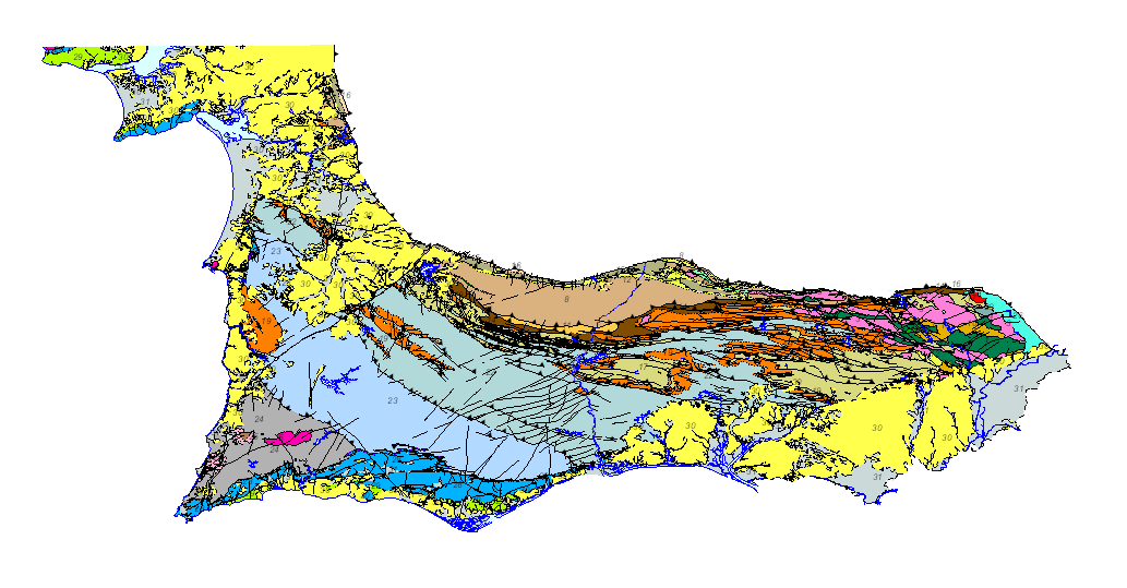
Mapa geológico de la Zona Surportuguesa, a escala 1:400.000, en el que se ha armonizado, con criterios unificados entre España y Portugal, la leyenda geológica a ambos lados de la frontera. Esta cartografía es un producto resultante del proyecto GEO_FPI: Observatorio transfronterizo para la valorización geo-económica de la Faja Pirítica Ibérica, cofinanciado por fondos FEDER a través del programa de cooperación territorial INTERREG POCTEP 2014-2020. El beneficiario principal del proyecto es el Instituto Geológico y Minero de España (IGME-CSIC), y forman parte del partenariado de este proyecto, la Dirección General de Industria, Energía y Minas de la Consejería de Hacienda, Industria y Energía de la Junta de Andalucía (DGIEM), el Laboratório Nacional de Energia e Geologia, I.P. (LNEG) y la Cámara Municipal de Aljustrel (CMA)
Geological map of the South Portuguese Zone, at a scale of 1:400,000, in which the geological legend on both sides of the border has been harmonized, with unified criteria between Spain and Portugal. This cartography is a product resulting from the GEO_FPI project: GEO_FPI: cross-border observatory for the geo-economic evaluation of the Iberian Pyrite Belt, financed by the European Regional Development Fund (ERDF) within the program INTERREG V-A Spain– Portugal (POCTEP) 2014-2020. The main beneficiary of the project is the Geological Survey of Spain (IGME-CSIC) . Additionally, the General Directorate of Industry, Energy and Mines of the Ministry of Employment, Enterprise and Commerce of the Andalusian Government (JA) and the Portuguese National Laboratory for Energy and Geology (LNEG) and the Municipal Chamber of Aljustrel (CMA) are partners of the project.
Carta geológica da Zona Sul Potuguesa, na escala de 1:400.000, em que a legenda geológica de ambos lados da fronteira foi harmonizada, com critérios unificados entre Espanha e Portugal. Esta cartografia é um produto resultante do Projeto Geo_FPI: Observatório Transfronteiriço para a Valorização Geo-Económica da Faixa Piritosa Ibérica, financiado pelo Fundo Europeu de Desenvolvimento Regional (FEDER) no âmbito do programa INTERREG VA Espanha - Portugal (POCTEP) 2014-2020. O beneficiário principal do projeto é o Instituto Geológico e Mineiro de Espanha (IGME-CSIC), tendo como parceiros a participação da Dirección General de Industria Energía y Minas de la Consejería de Empleo, Empresa y Comercio da Junta de Andaluzia (DGIEM), da Câmara Municipal de Aljustrel (CMA) e do Laboratório Nacional de Energia e Geologia (LNEG).
Simple
Identification info
Identification info
Información de Identificación
-
Date (Creation)Date (Creation)Fecha (Creación)
- 2019-07-01
-
Citation identifierCitation identifierIdentificador del Contacto
- IGME-CSIC / WMS_GEOFPI_GEOLOGICO400
- Point of contact
-
Organisation name Individual name Electronic mail address Role Instituto Geológico y Minero de España (IGME-CSIC)
Geological Survey of Spain (IGME-CSIC)
Instituto Geológico e Mineiro de Espanha (IGME-CSIC)
Point of contactPoint of contactPunto de ContactoInstituto Geológico y Minero de España (IGME-CSIC)
Geological Survey of Spain (IGME-CSIC)
Instituto Geológico e Mineiro de Espanha (IGME-CSIC)
CustodianCustodianGuardián
-
Tesauro IGME
Thesaurus IGME
IGME Thesausus
-
-
Alentejo
Alentejo
Alentejo
-
Algarve
Algarve
Algarve
-
Andalucía
Andalusia
Andalucia
-
Cartografía
Cartography
Mapeamento
-
Geología
Geology
Geologia
-
Cronoestratigrafía
Chronostratigraphy
Cronestratigrafia
-
España
Spain
Espanha
-
Portugal
Portugal
Portugal
-
- Keywords
-
-
400K
400K
400K
-
- Keywords
-
-
Faja Pirítica Ibérica.
Iberian Pyritic Belt
Cinturão Pyritic Ibérico.
-
- Keywords
-
-
Zona Surportuguesa.
Surportuguese zone
Zona Sul Portuguesa.
-
- Keywords
-
-
IGME
IGME
IGME
-
- Keywords
-
-
LNEG
LNEG
LNEG
-
- Keywords
-
-
EGDI
EGDI
EGDI
-
- Keywords
-
-
WMS
WMS
WMS
-
-
Especificaciones de Servicios Web
Web Services Specifications
Especificações de Serviços Web
-
-
OGC (Open Geospatial Consortium)
OGC (Open Geospatial Consortium)
OGC (Open Geospatial Consortium)
-
WMS (Web Map Service)
WMS (Web Map Service)
WMS (Web Map Service)
-
WMS 1.3.0
WMS 1.3.0
WMS 1.3.0
-
OGC
OGC
OGC
-
WMS
WMS
WMS
-
-
ISO - 19119 geographic services taxonomy
ISO - 19119 geographic services taxonomy
ISO - 19119 geographic services taxonomy
-
-
infoMapAccessService
infoMapAccessService
infoMapAccessService
-
-
INSPIRE_SpatialDataServicesClassification
INSPIRE_SpatialDataServicesClassification
INSPIRE_SpatialDataServicesClassification
-
-
Servicio de acceso a mapas
Map access service
Serviço de acesso ao mapa
-
Servicio de gestión de modelos/información geográficos
Geographic modelling/information management service
Serviço de modelação geográfica/gestão de informação
-
-
Access constraintsAccess constraintsRestricciones de Acceso
-
Other restrictionsOther restrictionsOtras restricciones
-
Otras limitacionesOther constraintsOther constraints
-
Sin limitaciones al acceso público.No limitations on public accessSem limitações no acesso público
-
Use constraintsUse constraintsRestricciones de uso
-
Other restrictionsOther restrictionsOtras restricciones
-
Otras limitacionesOther constraintsOther constraints
-
LICENCIA DE USO: Condiciones de uso público y difusión de la información para la reutilización de los datos IGME. https://www.igme.es/condiciones-de-uso/
LICENCE OF USE: Conditions of public use and dissemination of information for the re-use of IGME data. https://www.igme.es/condiciones-de-uso/
LICENÇA DE UTILIZAÇÃO: Condições de utilização pública e divulgação de informação para a reutilização de dados IGME. https://www.igme.es/condiciones-de-uso/
-
Service TypeService TypeTipo de Servicio
- view
))
-
Coupling TypeCoupling TypeTipo de acoplamiento
-
TightTightApretado
- Contains Operations
-
Operation Name Distributed Computing Platforms Connect Point GetCapabilities
Web servicesWeb servicesServicios webhttp://mapas.igme.es/gis/services/GeoFPI/GEOFPI_GEOLOGICO400/MapServer/WMSServer GetMap
Web servicesWeb servicesServicios webhttp://mapas.igme.es/gis/services/GeoFPI/GEOFPI_GEOLOGICO400/MapServer/WMSServer GetFeatureInfo
Web servicesWeb servicesServicios webhttp://mapas.igme.es/gis/services/GeoFPI/GEOFPI_GEOLOGICO400/MapServer/WMSServer
-
Operates OnOperates OnOpera En
-
Identificador único del recursoUnique resource identifier
-
EPSG:3857EPSG:3857
-
Identificador único del recursoUnique resource identifier
-
CRS:84CRS:84
-
Identificador único del recursoUnique resource identifier
-
EPSG:4258EPSG:4258
-
Identificador único del recursoUnique resource identifier
-
EPSG:4326EPSG:4326
-
Identificador único del recursoUnique resource identifier
-
EPSG:4230EPSG:4230
-
Identificador único del recursoUnique resource identifier
-
EPSG:23028EPSG:23028
-
Identificador único del recursoUnique resource identifier
-
EPSG:23029EPSG:23029
-
Identificador único del recursoUnique resource identifier
-
EPSG:23030EPSG:23030
-
Identificador único del recursoUnique resource identifier
-
EPSG:23031EPSG:23031
-
Identificador único del recursoUnique resource identifier
-
EPSG:25828EPSG:25828
-
Identificador único del recursoUnique resource identifier
-
EPSG:25829EPSG:25829
-
Identificador único del recursoUnique resource identifier
-
EPSG:25830EPSG:25830
-
Identificador único del recursoUnique resource identifier
-
EPSG:25831EPSG:25831
-
Identificador único del recursoUnique resource identifier
-
EPSG:102100EPSG:102100
- Distribution format
-
Name Version image/png
image/png
not applicable
image/jpeg
image/jpeg
not applicable
image/tiff
image/tiff
not applicable
image/gif
image/gif
not applicable
image/bmp
image/bmp
not applicable
- Distributor contact
-
Organisation name Individual name Electronic mail address Role Instituto Geológico y Minero de España (IGME-CSIC)
Geological Survey of Spain (IGME-CSIC)
DistributorDistributorDistribuidor
- OnLine resource
-
Protocol Linkage Name OGC:WMS-1.3.0-http-get-capabilities
http://mapas.igme.es/gis/services/GeoFPI/GEOFPI_GEOLOGICO400/MapServer/WMSServer?REQUEST=GetCapabilities&SERVICE=WMS Servicio de visualización (WMS) del Mapa geológico de la Zona SurPortuguesa 1:400.000
Visualisation service (WMS) of the Geological Map of the SouthPortuguese Area 1:400.000
Serviço de visualização (WMS) do Mapa Geológico da Área SulPortuguesa 1:400.000
-
Hierarchy levelHierarchy levelJerarquía
-
ServiceServiceServicio
- Other
-
Servicio web de datos espaciales. Servicio de visualización
Conformance result
Conformance result
Conformidad del Resultado
-
Date (Publication)Date (Publication)Fecha (Publicación)
- 2009-10-19
-
ExplicaciónExplanationExplanation
-
Consultar el reglamento mencionado
Consult the above-mentioned regulation
Consultar o regulamento acima mencionado
-
PassPassAprobado
- No
Conformance result
Conformance result
Conformidad del Resultado
-
TítuloTitleTitle
-
Reglamento (UE) n o 1089/2010 de la Comisión de 23 de noviembre de 2010 por el que se aplica la Directiva 2007/2/CE del Parlamento Europeo y del Consejo en lo que se refiere a la interoperabilidad de los conjuntos y los servicios de datos espaciales
Commission Regulation (EU) No 1089/2010 of 23 November 2010 implementing Directive 2007/2/EC of the European Parliament and of the Council as regards the interoperability of spatial data sets and services
Regulamento (UE) n.º 1089/2010 da Comissão, de 23 de Novembro de 2010, que aplica a Directiva 2007/2/CE do Parlamento Europeu e do Conselho no que respeita à interoperabilidade dos conjuntos e serviços de dados geográficos
-
Date (Publication)Date (Publication)Fecha (Publicación)
- 2010-12-08
-
ExplicaciónExplanationExplanation
-
Consultar el reglamento
Consult the regulations
Consultar o regulamento
-
PassPassAprobado
- No
Conformance result
Conformance result
Conformidad del Resultado
-
TítuloTitleTitle
-
REGLAMENTO (CE) No 1205/2008 DE LA COMISIÓN de 3 de diciembre de 2008 por el que se ejecuta la Directiva 2007/2/CE del Parlamento Europeo y del Consejo en lo que se refiere a los metadatos
COMMISSION REGULATION (EC) No 1205/2008 of 3 December 2008 implementing Directive 2007/2/EC of the European Parliament and of the Council as regards metadata
REGULAMENTO (CE) N.o 1205/2008 DA COMISSÃO de 3 de Dezembro de 2008 que aplica a Directiva 2007/2/CE do Parlamento Europeu e do Conselho no que diz respeito aos metadados
-
Date (Publication)Date (Publication)Fecha (Publicación)
- 2008-12-04
Citation identifier
Citation identifier
Identificador del Contacto
-
ExplicaciónExplanationExplanation
-
Consultar el reglamento mencionado
Consult the above-mentioned regulation
Consultar o regulamento acima mencionado
-
PassPassAprobado
- Yes
Metadata
-
File identifierFile identifierIdentificador del fichero
- ESPIGMESERVICIOFPIGEOLOGICO40020201201 XML
-
Metadata languageMetadata languageIdioma del metadato
- Spanish; Castilian
-
Character setCharacter setCodificación
-
UTF8UTF8UTF8
-
Hierarchy levelHierarchy levelJerarquía
-
ServiceServiceServicio
- Hierarchy level name
-
Servicio
-
Date stampDate stampFecha
- 2025-05-30T07:12:04.896684Z
- Metadata standard name
-
Reglamento (CE) Nº 1205/2008 de Inspire, "Perfil IGME"
- Metadata standard version
-
2.0
- Metadata author
-
Organisation name Individual name Electronic mail address Role Instituto Geológico y Minero de España (IGME-CSIC)
Geological Survey of Spain (IGME-CSIC)
Instituto Geológico e Mineiro de Espanha (IGME-CSIC)
Leticia Vega Martín
Point of contactPoint of contactPunto de Contacto
- Other language
-
Language Character encoding EnglishEnglishEnglishUTF8UTF8UTF8PortuguesePortuguesePortugueseUTF8UTF8UTF8Spanish; CastilianSpanish; CastilianSpanish; CastilianUTF8UTF8UTF8
)))