 Catalogo de metadatos IGME-CSIC
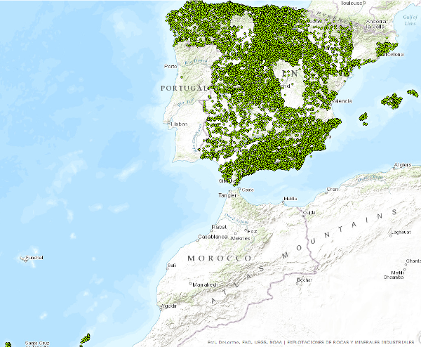
Visualisation Service (WMS) of the Mineral Resources Database (Industrial rocks and minerals)
The Service consists of two point layers that symbolize the location of the indications or exploitations of Industrial Rocks and Minerals for the entire national territory. Depending on the display scale, two point layers have been created. Exploitation I: represents only the location of the points. Visible from scales smaller than 1:200,000. Exploitation II: represents the location of the points with symbolization based on different attributes. Visible from scales larger than 1:200,000.
Simple
Identification info
- Date (Revision)
- 2014-05-01
- Citation identifier
- IGME-CSIC / WMS_BDMIN_RYMI
- Status
- Completed
- Point of contact
-
Organisation name Individual name Electronic mail address Role Research Group on Economic Geology of Mineral Resources (Gi-Gecomin).
Resource provider Geological Survey of Spain (IGME-CSIC)
Custodian
-
Minerals Intelligence Network for Europe register 1.0, 2014
-
-
Explotaciones subterráneas y a cielo abierto
-
Cantera
-
Productos Minerales
-
Minerales no metálicos
-
Yacimiento mineral
-
Explotación activa continua
-
Explotación abandonada
-
Minerals4EU
-
-
ISO - 19119 geographic services taxonomy, 1.0
-
-
Map access service
-
Geographic model/information management service
-
infoMapAccessService
-
infoManagementService
-
-
Especificación de servicios Web
-
-
OGC
-
Wms
-
1.3.0
-
- Keywords
-
-
EGDI
-
- Access constraints
- Other restrictions
- Other constraints
- Sin limitaciones al acceso público.
- Use constraints
- Other restrictions
- Other constraints
-
LICENCE OF USE: Conditions of public use and dissemination of information for the re-use of IGME data. https://www.igme.es/condiciones-de-uso/
- Service Type
- view
))
- Coupled Resource
-
Operation Name Scoped name Identifier ESPIGMEBDMINRYMI2015020613-1
- Coupling Type
- Tight
- Contains Operations
-
Operation Name Distributed Computing Platforms Connect Point GetCapabilities
Web services http://mapas.igme.es/gis/services/BasesDatos/IGME_BDMIN_Explotaciones/MapServer/WMSServer?Request=GetCapabilities&Service=WMS&version=1.3.0 GetMap
Web services http://mapas.igme.es/gis/services/BasesDatos/IGME_BDMIN_Explotaciones/MapServer/WMSServer GetFeatureInfo
Web services http://mapas.igme.es/gis/services/BasesDatos/IGME_BDMIN_Explotaciones/MapServer/WMSServer
- Distribution format
-
Name Version image/png
not applicable
image/jpeg
not applicable
image/tiff
not applicable
image/gif
not applicable
image/bmp
not applicable
- Distributor contact
-
Organisation name Individual name Electronic mail address Role Instituto Geológico y Minero de España (IGME-CSIC)
Distributor
- OnLine resource
-
Protocol Linkage Name OGC Web Map Service http://mapas.igme.es/gis/services/BasesDatos/IGME_BDMIN_Explotaciones/MapServer/WmsServer?Request=GetCapabilities&Service=WMS&version=1.3.0 Servicio de visualización (WMS) de la -Base de Datos de Recursos Minerales (Rocas y minerales Industriales)
- Hierarchy level
- Service
- Other
-
Servicio web de datos espaciales. Servicio de visualización
Conformance result
Conformance result
Conformance result
Metadata
- File identifier
- ESPIGMESERVICIOBDMINRYMI2015020613_1 XML
- Metadata language
- Spanish; Castilian
- Character set
- UTF8
- Hierarchy level
- Service
- Hierarchy level name
-
Servicio
- Date stamp
- 2025-06-11T12:04:26.687566Z
- Metadata standard name
-
Reglamento (CE) Nº 1205/2008 de Inspire, "Perfil IGME"
- Metadata standard version
-
2.0
- Metadata author
-
Organisation name Individual name Electronic mail address Role Geological Survey of Spain (IGME-CSIC)
Leticia Vega Martín
Point of contact
- Other language
-
Language Character encoding English UTF8 Spanish; Castilian UTF8
)))