 Catalogo de metadatos IGME-CSIC
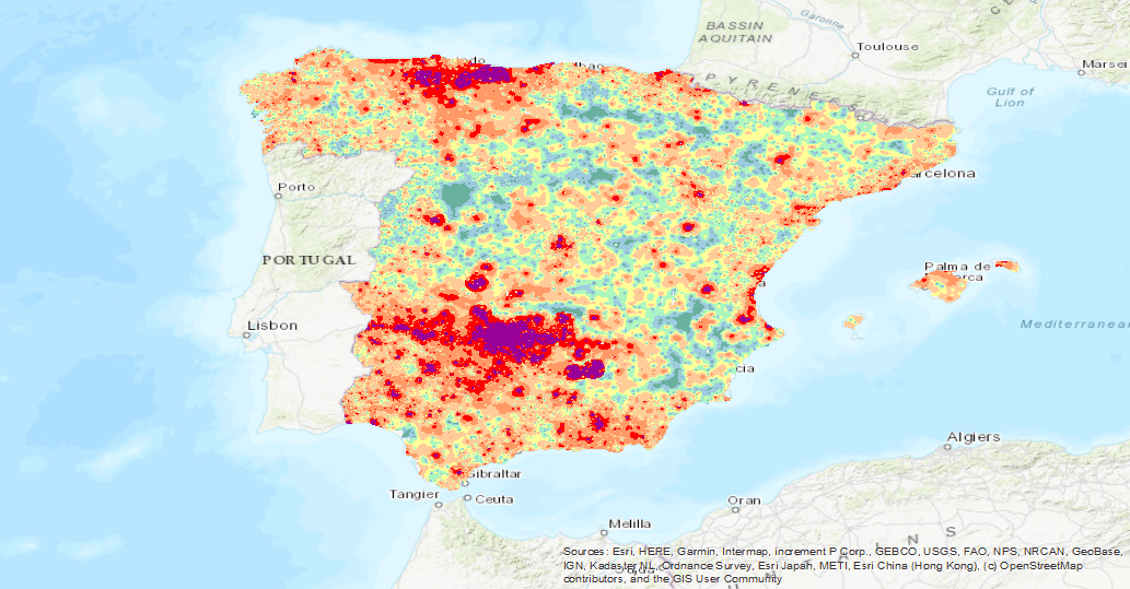
Visualisation service (WMS) of the Map of Mercury Isovalues (Geochemical Atlas of Spain, 2012).
Visualisation service of the Map of Mercury (Hg) isocontents, one of the chemical elements obtained in the Geochemical Atlas of Spain Project, distributed in stream sediments (14,864 samples), superficial soils (0-20 cm.) (13,505 samples) and deeper soils (20-40 cm.) (7,682 samples).
Simple
Identification info
- Date (Publication)
- 2012-01-01
- Status
- Completed
- Point of contact
-
Organisation name Individual name Electronic mail address Role Instituto Geológico y Minero de España (IGME-CSIC)
Distributor Instituto Geológico y Minero de España (IGME-CSIC)
Custodian
-
IGME Thesaurus
-
-
Geochemistry
-
Mercury
-
Analysis
-
Soils
-
Sediments
-
Elements
-
Quality control
-
Geochemical monitoring
-
Metallogeny
-
Atlas
-
Geochemical map
-
Sampling
-
Minerals
-
Metal
-
Mineral Resources
-
Ecosystems
-
España
-
- Keywords
-
-
Sample
-
Heatlh
-
IGCP 259
-
- Discipline
-
-
GeologY
-
Geochemistry
-
Mining
-
-
INSPIRE_SpatialDataServicesClassification
-
-
Map access service
-
infoMapAccessService
-
Geographic information/model management service
-
infoManagementService
-
-
Web Services Specifications
-
-
OGC (Open Geospatial Consortium)
-
WMS (Web Map Service)
-
WMS 1.3.0
-
OGC
-
WMS
-
- Access constraints
- Other restrictions
- Other constraints
- No Limitations
- Use constraints
- Other restrictions
- Other constraints
-
LICENCE OF USE: Conditions of public use and dissemination of information for the re-use of IGME data. https://www.igme.es/condiciones-de-uso/
- Service Type
- view
))
- Coupling Type
- Tight
- Contains Operations
-
Operation Name Distributed Computing Platforms Connect Point GetCapabilities
Web services https://mapas.igme.es/gis/services/AtlasGeoquimico/IGME_MapaIsovalores2012_Hg/MapServer/WMSServer GetMap
Web services https://mapas.igme.es/gis/services/AtlasGeoquimico/IGME_MapaIsovalores2012_Hg/MapServer/WMSServer GetFeatureInfo
Web services https://mapas.igme.es/gis/services/AtlasGeoquimico/IGME_MapaIsovalores2012_Hg/MapServer/WMSServer
- Distribution format
-
- OnLine resource
-
Protocol Linkage Name OGC Web Map Service https://mapas.igme.es/gis/services/AtlasGeoquimico/IGME_MapaIsovalores2012_Hg/MapServer/WMSServer?Request=GetCapabilities&Service=WMS Link to the GetCapabilities of the web service where the product is hosted
- Hierarchy level
- Service
- Other
-
Servicio de visualización
Conformance result
- Date (Publication)
- 2009-10-19
- Explanation
-
Consult the above-mentioned regulation
- Pass
- No
Conformance result
- Title
-
Reglamento (UE) n o 1089/2010 de la Comisión de 23 de noviembre de 2010 por el que se aplica la Directiva 2007/2/CE del Parlamento Europeo y del Consejo en lo que se refiere a la interoperabilidad de los conjuntos y los servicios de datos espaciales
- Date (Publication)
- 2010-12-08
- Explanation
-
Consult the regulation
- Pass
- No
Conformance result
- Title
-
REGLAMENTO (CE) No 1205/2008 DE LA COMISIÓN de 3 de diciembre de 2008 por el que se ejecuta la Directiva 2007/2/CE del Parlamento Europeo y del Consejo en lo que se refiere a los metadatos
- Date (Publication)
- 2008-12-04
Citation identifier
- Explanation
-
Consult the above-mentioned regulation
- Pass
- Yes
Metadata
- File identifier
- ESPIGMESERVICIOATLASGEOQUIMICAHG20210625 XML
- Metadata language
- Spanish; Castilian
- Character set
- UTF8
- Hierarchy level
- Service
- Hierarchy level name
-
Servicio
- Date stamp
- 2025-05-09T05:37:24.449724Z
- Metadata standard name
-
Reglamento (CE) Nº 1205/2008 de Inspire, "Perfil IGME"
- Metadata standard version
-
2.0
- Metadata author
-
Organisation name Individual name Electronic mail address Role Instituto Geológico y Minero de España (IGME-CSIC)
Leticia Vega Martín
Point of contact
- Other language
-
Language Character encoding English UTF8 Spanish; Castilian UTF8
)))