 Catalogo de metadatos IGME-CSIC
CARTOGRAFÍA DE LA SUSCEPTIBILIDAD A LOS DESPRENDIMIENTOS DE ROCAS EN LA ISLA DE EL HIERRO, ISLAS CANARIAS
CARTOGRAPHY OF ROCKFALLS SUSCEPTIBILITY IN THE ISLAND OF EL HIERRO, CANARY ISLANDS
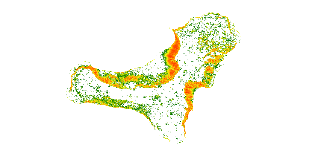
El mapa muestra el número de trayectorias que pasan por cada píxel.
The map show the number of trajectories that pass through each pixel.
Simple
-
Título alternativoAlternate title
-
MAPA DE SIMULACIÓN DE TRAYECTORIAS DE CAÍDA DE ROCAS EN LA ISLA DE EL HIERRO, ISLAS CANARIAS
MAP OF ROCKFALL TRAJECTORIES SIMULATION IN THE ISLAND OF EL HIERRO, CANARY ISLANDS
-
Date (Creation)Fecha (Creación)
- 2019-10-15
-
Edition dateFecha de edición
- 2019-10-15
-
Citation identifierIdentificador del Contacto
- IGME-CSIC / ESPIGMEROCKFALLSTRAJECTORIESELHIERRO
-
Presentation formFormulario de presentación
-
Hardcopy mapMapa en papel
-
Presentation formFormulario de presentación
-
Digital mapMapa digital
-
PropósitoPurpose
-
Los datos pueden utilizarse como entrada para calcular el riesgo de desprendimiento de rocas en la isla de El Hierro (Islas Canarias), y para estimar las posibles pérdidas económicas.
The data may be used as input to calculate rockfalls risk on the island of El Hierro (Canary Islands), and to estimate the potential economic losses.
-
CréditoCredit
-
Roberto Sarro Trigueros:(1); Rosa María Mateos Ruiz (1),Paola Reichenbach (2), Mauro Rossi (2)
(1)- Geological Survey of Spain (IGME-CSIC); (2)-Istituto di Ricerca per la Protezione Idrogeologica (IRPI), National Research Council (CNR)
Roberto Sarro Trigueros:(1); Rosa María Mateos Ruiz (1),Paola Reichenbach (2), Mauro Rossi (2).. (1)- Geological Survey of Spain (IGME-CSIC); (2)-Istituto di Ricerca per la Protezione Idrogeologica (IRPI), National Research Council (CNR)
-
StatusEstado
-
CompletedTerminado
- Point of contact
-
Organisation name Individual name Electronic mail address Role Instituto Geológico y Minero de España (IGME-CSIC)
Geological Survey of Spain (IGME-CSIC)
Roberto Sarro Trigueros
AuthorAutorInstituto Geológico y Minero de España (IGME-CSIC)
Geological Survey of Spain (IGME-CSIC)
Rosa María Mateos Ruiz
AuthorAutorInstituto de Investigación para la Protección Hidrogeológica, Consejo Nacional de Investigación (CNR-IRPI)
Research Institute for Hydrogeological Protection, National Research Council (CNR-IRPI)
Paola Reichenbach
AuthorAutorInstituto de Investigación para la Protección Hidrogeológica, Consejo Nacional de Investigación (CNR-IRPI)
Research Institute for Hydrogeological Protection, National Research Council (CNR-IRPI)
Mauro Rossi
AuthorAutor
-
Maintenance and update frequencyMantenimiento y frecuencia de actualización
-
Not plannedSin planificar
- Keywords
-
-
IGME
IGME
-
Riesgos Geológicos
Geological hazards
-
infoMapAccessService
infoMapAccessService
-
-
Tesauro IGME
Tesauro IGME
-
-
Desprendimientos de rocas
Rockfalls
-
Trajectoría
Trajectory
-
Riesgo
Risk
-
Peligro
Hazard
-
Medio volcánico
volcanic environment
-
Islas Canarias
Canary Islands
-
-
DisciplineDisciplina
-
-
Riesgos Geológicos
Geohazards
-
- Keywords
-
-
EGDI
EGDI
-
-
Uso específicoSpecific usage
-
Cartografía de riesgo de desprendimiento de rocas, Vulnerabilidad, Gestión de emergencias, Planificación urbana
Rockfall risk mapping, Vulnerability, Emergency management, Urban planning
- User contact info
-
Organisation name Individual name Electronic mail address Role Instituto Geológico y Minero de España (IGME-CSIC)
Geological Survey of Spain (IGME-CSIC)
Point of contactPunto de Contacto
-
Access constraintsRestricciones de Acceso
-
Other restrictionsOtras restricciones
-
Otras limitacionesOther constraints
-
Sin limitaciones al acceso público.No limitations to public access.
-
Use constraintsRestricciones de uso
-
Other restrictionsOtras restricciones
-
Otras limitacionesOther constraints
-
LICENCIA DE USO: Condiciones de uso público y difusión de la información para la reutilización de los datos IGME. https://www.igme.es/condiciones-de-uso/
LICENSE FOR USE: Conditions governing the public use and dissemination of the information for the re-use of the IGME data. https://www.igme.es/condiciones-de-uso/
-
Use constraintsRestricciones de uso
-
Other restrictionsOtras restricciones
-
Spatial representation typeTipo de representación espacial
-
GridMalla
-
DenominatorDenominador
- 25000
-
DenominatorDenominador
- 50000
-
DenominatorDenominador
- 1000000
-
LanguageIdioma
- English
-
Character setCodificación
-
UTF8UTF8
-
Topic categoryCategoría temática
-
-
Geoscientific informationInformación geocientífica
-
))
-
Extent type codeCódigo del tipo de extensión
- Yes
-
Geographic identifierIdentificador geográfico
-
ESES
-
Identificador único del recursoUnique resource identifier
-
EPSG:4258EPSG:4258
-
Identificador único del recursoUnique resource identifier
-
EPSG:32628EPSG:32628
- Distribution format
-
Name Version GRID (Restricted use)Unknown
Web Map Service WMS
1.3.0
Distributor
Distribuidor
- Distributor contact
-
Organisation name Individual name Electronic mail address Role Instituto Geológico y Minero de España (IGME-CSIC)
Geological Survey of Spain (IGME-CSIC)
DistributorDistribuidor
- Fees
-
Distribution through the web
- Distributor format
-
Name Version Digital:Map GRID - ArcView RasterFile
Not applicable
Joint Photographic Group Format JPEG
No se aplica
Tagged Image File FormatTIFF
No se aplica
Web Map Service WMS
1.3.0
- Distributor contact
-
Organisation name Individual name Electronic mail address Role Área de Sistemas de Información Geológica del Instituto Geológico y Minero de España (IGME-CSIC)
Geological Information Systems Department of the Geological and Mining Institute of Spain (IGME-CSIC)
DistributorDistribuidor
- OnLine resource
-
Protocol Linkage Name Visualization service of the map of rockfall trajectories simulation in the island of El Hierro, Canary Islands
http://mapas.igme.es/gis/services/UGeoHaz/UGEOHAZ_ROCKFALLTRAJECTORIES_ELHIERRO/MapServer/WMSServer?REQUEST=GetCapabilities&SERVICE=WMS WWW:LINK-1.0-http--link
http://www.igme.es Descarga del mapa de simulación de trayectorias de caída de rocas en la isla de El Hierro, Canarias
Download of the map of rockfall trajectories simulation in the island of El Hierro, Canary Islands
-
Hierarchy levelJerarquía
-
DatasetConjunto de datos
Conformance result
Conformidad del Resultado
-
Date (Publication)Fecha (Publicación)
- 2009-10-19
-
ExplicaciónExplanation
-
ConformeConformant
-
PassAprobado
- Yes
Conformance result
Conformidad del Resultado
-
Date (Publication)Fecha (Publicación)
- 2014-12-31
-
ExplicaciónExplanation
-
Los datos no son conformesData are no conformant
-
PassAprobado
- No
Conformance result
Conformidad del Resultado
-
TítuloTitle
-
Reglamento (CE) No 1205/2008 de la Comisión de 3 de Diciembre de 2008 que establece las modalidades de aplicación de la Directiva 2007/2/CE del Parlamento Europeo y del Consejo em materia de metadados
Commission Regulation (EC) No 1205/2008 of 3 December 2008 laying down detailed rules for the implementation of Directive 2007/2/EC of the European Parliament and of the Council as regards metadata
-
Date (Publication)Fecha (Publicación)
- 2008-12-04
-
ExplicaciónExplanation
-
Consultar el reglamento
See the above-mentioned regulation
-
PassAprobado
- Yes
-
DeclaraciónStatement
-
Este trabajo se ha desarrollado en el marco del proyecto U-GEOHAZ (Geohazard Impact Assessment for Urban Areas), financiado por la Comisión Europea, Dirección General de Ayuda Humanitaria y Protección Civil (ECHO), Acuerdo de Subvención nº 783169.
This work has been developed in the framework of the U-GEOHAZ project (Geohazard Impact Assessment for Urban Areas), funded by the European Commission, Directorate-General Humanitarian Aid and Civil Protection (ECHO), Grant Agreement No. 783169.
-
DescripciónDescription
-
Etapa 1 - Colección de cartografía temática
Stage 1 - Collection of thematic cartographic.
-
DescripciónDescription
-
Etapa 2 - Preparación de los datos de entrada en formato ascii
Stage 2 - Preparation of input data in ascii format
-
DescripciónDescription
-
Etapa 3 - Simulation the trajectories using STONE code (Guzzetti et al. 2002). The software uses GIS technology to produce 2D-3D raster outputs.
Stage 3 - Simulación de trayectorias mediante el código STONE (Guzzetti et al., 2002). El software utiliza tecnología SIG para generar resultados ráster 2D-3D.
-
DescripciónDescription
-
Este mapa representa las zonas con mayor susceptibilidad a la caída de rocas. Los datos se han obtenido a partir de la información geológica y del terreno. El MDE de entrada fue generado por el Instituto Geográfico Nacional a una resolución de 5m x 5m. De acuerdo con el Mapa Geológico Nacional Continuo de España (GEODE) disponible en el IGME (www.igme.es), se diferenciaron las unidades litológicas y se obtuvieron sus coeficientes.
This map represents the areas with higher rockfall susceptibility. The data was derived from terrain and geological information. The input DEM was generated by the National Geographic Institute at a 5m x 5m resolution. According to the available National Geological Continuous Map of Spain (GEODE) from IGME (www.igme.es), lithological units were differentiated and their coefficients were obtained.
-
DenominatorDenominador
- 50000
Metadata
-
File identifierIdentificador del fichero
- ESPIGMEROCKFALLSTRAJECTORIESELHIERRO20191031 XML
-
Metadata languageIdioma del metadato
- Spanish; Castilian
-
Character setCodificación
-
UTF8UTF8
-
Hierarchy levelJerarquía
-
DatasetConjunto de datos
-
Date stampFecha
- 2026-03-11T17:27:10.005518Z
- Metadata standard name
-
Reglamento (CE) Nº 1205/2008 de Inspire, "Perfil IGME"
- Metadata standard version
-
2.0
- Metadata author
-
Organisation name Individual name Electronic mail address Role Instituto Geológico y Minero de España (IGME-CSIC)
Geological Survey of Spain (IGME-CSIC)
Leticia Vega Martín
Point of contactPunto de Contacto
- Other language
-
Language Character encoding EnglishEnglishUTF8UTF8Spanish; CastilianSpanish; CastilianUTF8UTF8
)))