 Catalogo de metadatos IGME-CSIC
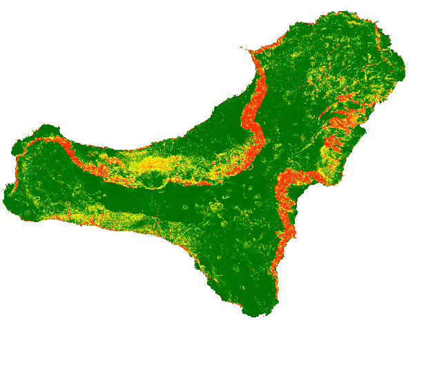
CARTOGRAPHY OF ROCKFALLS SOURCE AREAS IN THE ISLAND OF EL HIERRO, CANARY ISLANDS
The map shows a probabilistic identification of rockfall source areas for El Hierro Island, prepared with the combination of multiple statistical models. To run the models, we have used observed source areas as dependent variable and a set of thematic information as independent variables (e.g., morphometric parameters derived from the DTM, lithological information that considers the mechanical behaviour of the rocks).
Simple
- Alternate title
-
PROBABILISTIC ROCKFALL SOURCE AREAS MAP IN THE ISLAND OF EL HIERRO, CANARY ISLANDS
- Date (Creation)
- 2019-10-15
- Edition date
- 2019-10-15
- Citation identifier
- / ESPIGMEROCKFALLSOURCEAREASELHIERRO
- Presentation form
- Hardcopy map
- Presentation form
- Digital map
- Purpose
-
The map shows the probability of each single pixel to be a rock fall source area and can be used as input for rockfall regional modelling in El Hierro (Canary Island)
- Credit
-
Roberto Sarro Trigueros:(1); Rosa María Mateos Ruiz (1),Paola Reichenbach (2), Mauro Rossi (2).. (1)- Geological Survey of Spain (IGME-CSIC); (2)->Research Institute for Hydrogeological Protection, National Research Council (CNR-IRPI)
- Status
- Completed
- Point of contact
-
Organisation name Individual name Electronic mail address Role Geological Survey of Spain (IGME-CSIC)
Roberto Sarro Trigueros
Author Geological Survey of Spain (IGME-CSIC)
Rosa María Mateos Ruiz
Author Research Institute for Hydrogeological Protection, National Research Council (CNR-IRPI)
Paola Reichenbach
Author Research Institute for Hydrogeological Protection, National Research Council (CNR-IRPI)
Mauro Rossi
Author
- Maintenance and update frequency
- Not planned
- Keywords
-
-
IGME
-
Geological hazards
-
infoMapAccessService
-
-
IGME Thesaurus
-
-
Rockfalls
-
Trajectory
-
Risk
-
Hazard
-
volcanic environment
-
Canary Islands
-
- Discipline
-
-
Geohazards
-
- Keywords
-
-
EGDI
-
- Specific usage
-
Rockfall risk mapping, Vulnerability, Emergency management, Urban planning
- User contact info
-
Organisation name Individual name Electronic mail address Role Geological Survey of Spain (IGME-CSIC)
Point of contact
- Access constraints
- Other restrictions
- Other constraints
- No limitations to public access.
- Use constraints
- Other restrictions
- Other constraints
-
LICENSE FOR USE: Conditions governing the public use and dissemination of the information for the re-use of the IGME data. http://www.igme.es/Ayuda/CondiUso.htm
- Use constraints
- Other restrictions
- Spatial representation type
- Grid
- Denominator
- 25000
- Denominator
- 50000
- Denominator
- 1000000
- Language
- English
- Character set
- UTF8
- Topic category
-
- Geoscientific information
))
- Extent type code
- Yes
- Geographic identifier
- ES
- Distribution format
-
Name Version GRID (Restricted use) Unknown
Web Map Service WMS
1.3.0
Distributor
- Distributor contact
-
Organisation name Individual name Electronic mail address Role Geological Survey of Spain (IGME-CSIC)
Distributor
- Fees
-
Distribution through the web
- Distributor format
-
Name Version Digital:Map GRID - ArcView RasterFile
Not applicable
Joint Photographic Group Format JPEG
No se aplica
Tagged Image File FormatTIFF
No se aplica
Web Map Service WMS
1.3.0
- Distributor contact
-
Organisation name Individual name Electronic mail address Role Technical Vice-Directorate of Geological Information Systems of the Geological Survey of Spain (IGME-CSIC)
Distributor
- OnLine resource
-
Protocol Linkage Name Visualization serviceof the probabilistic map of rockfalls source areas source in the island of El hierro (Canary Islands)
http://mapas.igme.es/gis/services/UGeoHaz/UGEOHAZ_ROCKFALLSOURCEAREAS_ELHIERRO/MapServer/WMSServer?REQUEST=GetCapabilities&SERVICE=WMS WWW:LINK-1.0-http--link
http://www.igme.es Download of the probabilistic map of rockfalls source areas source in the island of El hierro (Canary Islands)
- Hierarchy level
- Dataset
Conformance result
Conformance result
Conformance result
- Title
-
Commission Regulation (EC) No 1205/2008 of 3 December 2008 laying down detailed rules for the implementation of Directive 2007/2/EC of the European Parliament and of the Council as regards metadata
- Date (Publication)
- 2008-12-04
- Explanation
-
See the above-mentioned regulation
- Pass
- Yes
- Statement
-
This work has been developed in the framework of the U-GEOHAZ project (Geohazard Impact Assessment for Urban Areas-, funded by the European Commission, Directorate-General Humanitarian Aid and Civil Protection (ECHO), Grant Agreement No. 783169
- Description
-
Stage 1 - Collection of thematic cartographic.
- Description
-
Stage 2 - Elaboration of potential and active rockfalls areas maps in El Golfo, Sabinosa, Las Playas and La Estaca. .
- Description
-
Stage 3 - Development of probabilistic analysis using LAND-SUITE software carried out by Rossi and Reichenbach from CNR-IRPI (Italy).
- Description
-
The following thematic information have been used as independent variables: slope angle, curvature, lithology, and dyke density. Slope angle and curvature were calculated from the 5-meter DEM derived from LIDAR data provided by the National Geographic Institute (IGN-CNIG). The lithology information, derives from the geological map of the Geological Survey of Spain at 1:25000 scale.
- Denominator
- 50000
Metadata
- File identifier
- ESPIGMEROCKFALLSOURCEAREASELHIERRO20191031 XML
- Metadata language
- Spanish; Castilian
- Character set
- UTF8
- Hierarchy level
- Dataset
- Date stamp
- 2025-05-30T08:10:11.228527Z
- Metadata standard name
-
Reglamento (CE) Nº 1205/2008 de Inspire, "Perfil IGME"
- Metadata standard version
-
2.0
- Metadata author
-
Organisation name Individual name Electronic mail address Role Geological Survey of Spain (IGME-CSIC)
Leticia Vega Martín
Point of contact
- Other language
-
Language Character encoding English UTF8 Spanish; Castilian UTF8
)))