 Catalogo de metadatos IGME-CSIC
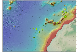
Underwater mineral resources of the Canary Islands, polymetallic nodules.
Cartography of polymetallic nodules deposits in which the mineralogical characterization, metallogenetic data and location are described, among other elements.
Simple
- Date (Creation)
- 2020-12-02
- Citation identifier
- / ESPIGMERECURSOSMINERALESSUBMARINOSNODULOSCANARIAS
- Purpose
-
Distribution and characterization of polymetallic nodules deposits in the Canary Island Seamount Province.
- Credit
-
Teresa Medialdea Cela (IGME), Luis Somoza Losada (IGME), Francisco Javier González Sanz (IGME), Ana Belén Lobato Otero (IGME), Egidio Marino (IGME), Iker Blasco del Barrio (Personal Libre)
- Status
- On going
- Point of contact
-
Organisation name Individual name Electronic mail address Role Geological Survey of Spain (IGME-CSIC)
Teresa Medialdea Cela
Principal investigator Geological Survey of Spain (IGME-CSIC)
Luis Somoza Losada
Principal investigator Geological Survey of Spain (IGME-CSIC)
Francisco Javier González Sanz
Principal investigator Geological Survey of Spain (IGME-CSIC)
Ana Belén Lobato Otero
Originator Geological Survey of Spain (IGME-CSIC)
Egidio Marino
Originator Geological Survey of Spain (IGME-CSIC)
Iker Blasco del Barrio
Originator
- Maintenance and update frequency
- Not planned
-
IGME Thesaurus
-
-
Marine geology
-
Nodules
-
Polymetallic ores
-
Canary ISlands
-
Atlantic Ocean
-
Seamount
-
Ferromanganese composition
-
Manganese
-
Nickel
-
Diagenesis
-
- Discipline
-
-
Marine Geology
-
Chemical Elements
-
Sedimentology and sedimentary petrology
-
Geography - Systematics
-
- Specific usage
-
Geological mapping and research of mineral resources.
- User contact info
-
Organisation name Individual name Electronic mail address Role Spanish Geological Survey (IGME-CSIC)
Point of contact
- Access constraints
- Other restrictions
- Other constraints
- No Limitations
- Use constraints
- Other restrictions
- Other constraints
-
LICENCE OF USE: Conditions of public use and dissemination of information for the re-use of IGME data http://www.igme.es/Ayuda/CondiUso.htm
- Use constraints
- Other restrictions
- Spatial representation type
- Vector
- Denominator
- 250000
- Language
- Spanish; Castilian
- Character set
- UTF8
- Topic category
-
- Geoscientific information
))
- Extent type code
- Yes
- Geographic identifier
- ES
- Unique resource identifier
- EPSG:4081(REGCAN95)
- Distribution format
-
Name Version Shape file (Uso restringido)
ArcGIS 10.5
Distributor
- Distributor contact
-
Organisation name Individual name Electronic mail address Role Geological Survey of Spain (IGME-CSIC)
Distributor
- Fees
-
Distribución a través de la web
- OnLine resource
-
Protocol Linkage Name http://info.igme.es/cartografiadigital/datos/marina/canarias/nodulosPol.zip Shape of polymetallic nodules (Submarine Mineral Resources of the Canary Islands)
- Hierarchy level
- Dataset
Conformance result
Conformance result
- Title
-
Reglamento (CE) n.o 1205/2008 de la Comisión de 3 de Diciembre de 2008 que estabelece las modalidades de aplicación de la Directiva 2007/2/CE del Parlamento Europeo y del Consejo em materia de metadados
- Date (Publication)
- 2008-12-04
- Explanation
-
Consult the regulations
- Pass
- Yes
- Statement
-
Cruises organized by the IGME, publications and web servers.
- Description
-
Stage 1 - Compilation of cartographic information through oceanographic sampling campaigns, using trawl dredges (DR) and Remotely Operated Vehicle (ROV).
- Description
-
Stage 2 - Study of the samples obtained in the oceanographic campaigns through laboratory analysis: X-Ray Fluorescence (XRF), X-Ray Diffraction (XRD), Inductively Coupled Plasma Mass Spectrometry (ICP-MS), Atomic Emission Spectrometry (ICP-AES), Atomic Absorption (AA) and Scanning Electron Microscopy (SEM).
- Description
-
MINDeSEA Project ( https://geoera.eu/projects/mindesea2/) and EMODnet Geology ( https://www.emodnet-geology.eu/).
- Denominator
- 250000
Metadata
- File identifier
- ESPIGMERECURSOSMINERALESSUBMARINOSNODULOSCANARIAS20201130 XML
- Metadata language
- Spanish; Castilian
- Character set
- UTF8
- Hierarchy level
- Dataset
- Date stamp
- 2025-05-09T07:24:22.271555Z
- Metadata standard name
-
Reglamento (CE) Nº 1205/2008 de Inspire, "Perfil IGME"
- Metadata standard version
-
2.0
- Metadata author
-
Organisation name Individual name Electronic mail address Role Geological Survey of Spain (IGME-CSIC)
Leticia Vega Martín
Point of contact
- Other language
-
Language Character encoding English UTF8 Spanish; Castilian UTF8
)))