 Catalogo de metadatos IGME-CSIC
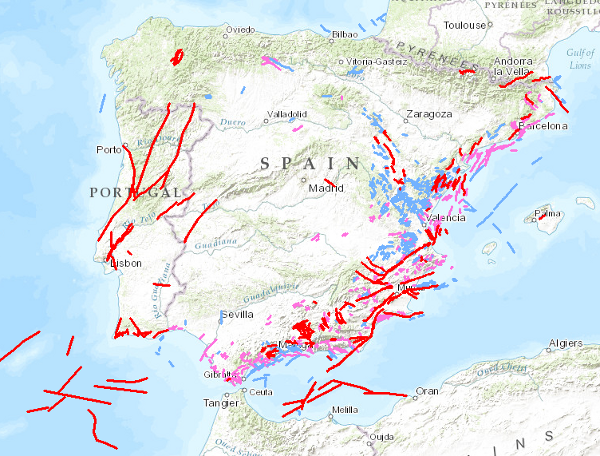
Quaternary Fault Database of the Iberian Peninsula (QAFI)
QAFI is a database of faults with geological evidence of proven activity during the Quaternary period (the last 2.6 million years according to the limit officially established by the SQS in 2009) of the Iberian Peninsula.
It is a project in constant revision and updating as a result of the progress of studies and knowledge about the structures capable of generating earthquakes in Iberia, and can never be considered complete or definitive, both because of the scientific nature of the data contained in it, and because of the modus operandi used in its construction: the altruistic collaboration of numerous researchers in Earth Sciences.
QAFI, both in Access format and geospatially represented, is hosted and maintained by the Geological Survey of Spain (IGME-CSIC), and is accessible to the entire scientific and technical community and society in general.
Simple
- Alternate title
-
QAFI
- Date (Creation)
- 2010-10-19
- Date (Publication)
- 2012-02-07
- Date (Revision)
- 2012-02-07
- Citation identifier
- ESPIGMEQAFI
- Presentation form
- Digital map
- Presentation form
- Digital document
- Purpose
-
The QAFI database has two main objectives: the storage and dissemination of information on the active quaternary faults of the Iberian Peninsula in a technologically updated and dynamic format, as well as contributing to improving seismic hazard estimates and making critical infrastructure projects and emergency or land-use plans more effective and optimal.
- Credit
-
Technical Editor: Santiago Martín Alfageme.
Web application: Ángel Prieto Martín.
Science Editors: Julián García Mayordomo (IGME-CSIC), Juan M. Insua Arévalo (U. Complutense de Madrid), Jose Jesús Martínez Díaz (U. Complutense de Madrid), Alberto Jiménez Díaz (U. Complutense de Madrid), Raquel Martín Banda (IGME-CSIC), Jose A. Álvarez Gómez (U. Cantabria), Raúl Pérez López (IGME-CSIC), Miguel Ángel Rodríguez Pascua (IGME-CSIC), Martín Rodríguez Peces (U. Complutense de Madrid), Jorge Giner Robles (U. Autónoma de Madrid), Fidel Martín González (U. Rey Juan Carlos), Eulalia Masana (U. Barcelona), Héctor Perea (Universidade de Lisboa, Portugal), Eliza S. Nemser (Intituto Superior Técnico, Portugal), João Cabral (Universidade de Lisboa, Portugal).
Metadata Editor: Raquel Martín Banda (IGME-CSIC).
- Status
- Completed
- Point of contact
-
Organisation name Individual name Electronic mail address Role Geological Survey of Spain (IGME-CSIC)
Julián García Mayordomo
Point of contact
- Maintenance and update frequency
- Annually
- Keywords
-
-
IGME
-
Iberian
-
Palaeoseismology
-
Tectonics
-
Seismic Hazard
-
-
IGME Thesaurus
-
-
Quaternary
-
Fault
-
-
GEMET
-
-
Geology
-
NATURAL ENVIRONMENT, ANTHROPIC ENVIRONMENT
-
LITHOSPHERE (soil, geological processes)
-
Geological processes
-
Seismic activity
-
Earthquakes
-
- Keywords
-
-
Seismic Hazards
-
-
CEOLocation
-
-
COUNTRIES
-
SPAIN
-
PORTUGAL
-
-
EuropeanTerritorialUnits
-
-
SPAIN
-
- Keywords
-
-
Iberia
-
- Keywords
-
-
EGDI
-
InventoryGM
-
- Specific usage
-
The QAFI database has two main objectives: the storage and dissemination of information on the active quaternary faults of the Iberian Peninsula in a technologically updated and dynamic support, as well as contributing to improve seismic hazard estimates and to make critical infrastructure projects and emergency or land-use plans more effective and optimal.
- User contact info
-
Organisation name Individual name Electronic mail address Role Geological Survey of Spain (IGME-CSIC)
Point of contact
- Access constraints
- Other restrictions
- Other constraints
- No limitations on public access
- Use constraints
- Other restrictions
- Other constraints
- CC BY-SA 4.0 IGME-CSIC
- Title
-
Neotectonic Map of Spain at Scale 1:1,000,000
- Date (Creation)
- 1990-12-03
- Citation identifier
- 26045
- Cited responsible party
-
Organisation name Individual name Electronic mail address Role Geological Survey of Spain (IGME-CSIC)
Point of contact
- Association Type
- Cross reference
- Spatial representation type
- Vector
- Denominator
- 200000
- Language
- English
- Character set
- 8859 Part 1
- Topic category
-
- Geoscientific information
- Description
-
Iberian Peninsula (Spain and Portugal)
))
- Supplemental Information
-
QAFI has been funded and supported by the following research projects: FASE-GEO (CGL2009-09726-/BTE), IBERFAULT (CGL2009-07388-E/BTE) and SHARE (FP7-226967).
The database has been created with Access 2003 from Microsoft, Inc. To open it correctly, it is necessary to use Access 2003 or a later version and to enable macros.
QAFI is also online at https://info.igme.es/qafi/, where the fault traces of the database are displayed on the GoogleMap interface.
- Unique resource identifier
- EPSG:4326
- Unique resource identifier
- EPSG:4258
- Unique resource identifier
- EPSG:4230
- Unique resource identifier
- EPSG:23028
- Unique resource identifier
- EPSG:23029
- Unique resource identifier
- EPSG:23030
- Unique resource identifier
- EPSG:23031
- Unique resource identifier
- EPSG:25828
- Unique resource identifier
- EPSG:25829
- Title
-
European Petroleum Surgey Group
- Date (Creation)
- 1986-01-01
- Unique resource identifier
- EPSG:25830
- Unique resource identifier
- EPSG:25831
- Unique resource identifier
- EPSG:3857
- Unique resource identifier
- EPSG:102100
- Distribution format
-
Name Version Digital map: SHP - ArcGIS ShapeFile
9.2
Digital map: MDB - Microsoft Data Base
2003
Hardcopy map
Unknown
Web Map Service - WMS
1.3.0
Distributor
- Distributor contact
-
Organisation name Individual name Electronic mail address Role Geological Survey of Spain (IGME-CSIC)
Distributor
- Fees
-
Gratuito
- Distributor format
-
Name Version Digital map: SHP - ArcView ShapeFile
9.2
Digital map: MDB - Microsoft Data Base
2003
Distributor
- Distributor contact
-
Organisation name Individual name Electronic mail address Role Documentation Centre of the Geological Survey of Spain (IGME-CSIC)
Distributor
- Distributor format
-
Name Version Hardcopy map
-
Distributor
- Distributor contact
-
Organisation name Individual name Electronic mail address Role Geological Information Systems Department. Geological Survey of Spain (IGME-CSIC)
Distributor
- Distributor format
-
Name Version Web Map Service - WMS
1.3.0
- Units of distribution
-
Las unidades de información que comprenden esta base de datos son las siguientes: Identificación-compilación. Geometría y cinemática. Actividad cuaternaria. Parámetros sísmicos. Sismicidad asociada. Información extendida y referencias.
- OnLine resource
-
Protocol Linkage Name OGC:WMS-1.3.0-http-get-capabilities
http://mapas.igme.es/gis/services/BasesDatos/IGME_QAFI/MapServer/WMSServer?service=wms&request=getcapabilities&version=1.3.0 Link to the GetCapabilities of the web service hosting the product
WWW:LINK-1.0-http--related
http://mapas.igme.es/Servicios/default.aspx#IGME_QAFI Link to the GetCapabilities of the web service hosting the product
WWW:LINK-1.0-http--related
https://info.igme.es/qafi/ QAFI access application access link
- Hierarchy level
- Dataset
Completeness commission
- Name of measure
-
Presence of duplicated faults
- Measure description
-
Automatic control. Manual verification
Conformance result
- Title
-
Automatic control. Manual checking. Presence of duplicate faults
- Date (Revision)
- 2012-02-07
Citation identifier
- Explanation
-
Error rate: 0%
- Pass
- Yes
Completeness commission
- Name of measure
-
Presence of non-inventoried faults%
- Measure description
-
Automatic control. Manual verification
Conformance result
- Title
-
Automatic control. Manual verification. Presence of non-inventoried faults
- Date (Revision)
- 2012-02-07
Citation identifier
- Explanation
-
Error rate 0 %
- Pass
- Yes
Completeness omission
- Name of measure
-
No faults inventoried
- Measure description
-
Automatic control. Manual verification.
Conformance result
- Title
-
Automatic control. Manual verification. Absence of inventoried faults
- Date (Revision)
- 2012-02-07
Citation identifier
- Explanation
-
Error rate: 0%
- Pass
- Yes
Conceptual consistency
- Name of measure
-
Degree of approximation between the physical structure of the database and the conceptual model
- Measure description
-
Manual verification
Conformance result
- Title
-
Manual verification. Degree of approximation between the physical structure of the database and the conceptual model.
- Date (Revision)
- 2012-02-07
Citation identifier
- Explanation
-
Agreed
- Pass
- Yes
Conceptual consistency
- Name of measure
-
Existence of values outside the established range for each attribute
- Measure description
-
Manual verification
Conformance result
- Title
-
Manual verification
- Date (Revision)
- 2012-02-07
Citation identifier
- Explanation
-
Agreed
- Pass
- Yes
Format consistency
- Name of measure
-
Degree of approximation of the data to the established physical structure.
- Measure description
-
Manual verification.
Conformance result
- Title
-
Own project specification
- Date (Revision)
- 2012-02-07
Citation identifier
- Explanation
-
Agreed
- Pass
- Yes
Absolute external positional accuracy
- Name of measure
-
Difference between the real position of the fault and the position resulting from the estimation or measurement of its coordinates.
- Measure description
-
Although all compilers were supposed to work on the same mdt and with the same coordinate system (ETRS89-zone30), the reality has been different and variable errors are observed.
Conformance result
- Title
-
Difference between the real position of the fault and the position resulting from the estimation or measurement of its coordinates.
- Date (Revision)
- 2012-02-07
Citation identifier
- Explanation
-
Error < 700 m
- Pass
- No
Thematic classification correctness
- Name of measure
-
Degree of fidelity of attribute values
- Measure description
-
Manual verification
Conformance result
- Title
-
Own project specification
- Date (Revision)
- 2012-02-07
Citation identifier
- Explanation
-
Conformant
- Pass
- Yes
Non quantitative attribute accuracy
- Name of measure
-
Degree of semantic accuracy of attributes
- Measure description
-
Verificación manual
Conformance result
- Title
-
Manual verification. Degree of semantic accuracy of attributes
- Date (Revision)
- 2012-02-07
Citation identifier
- Explanation
-
Conformant
- Pass
- Yes
Accuracy of time measurement
- Name of measure
-
Errors in data update date
- Measure description
-
Manual verification
Conformance result
- Title
-
Manual check. Errors in data update date
- Date (Revision)
- 2012-02-07
Citation identifier
- Explanation
-
Conformant
- Pass
- Yes
Temporal validity
- Name of measure
-
Validity over time of the specified dataset
- Measure description
-
Manual verification
Conformance result
- Title
-
Manual verification. Validity over time of the specified data set.
- Date (Revision)
- 2012-02-07
Citation identifier
- Explanation
-
Conformant
- Pass
- Yes
Conformance result
Conformance result
- Title
-
REGLAMENTO (CE) No 1205/2008 DE LA COMISIÓN de 3 de diciembre de 2008 por el que se ejecuta la Directiva 2007/2/CE del Parlamento Europeo y del Consejo en lo que se refiere a los metadatos
- Date (Publication)
- 2008-12-04
- Explanation
-
Consult the above-mentioned regulation
- Pass
- Yes
- Statement
-
Firstly, the scientific design of the database was carried out after reviewing other existing databases related to the subject (U.S. Geological Survey - http://earthquakes.usgs.gov/regional/qfaults/), New Zealand GNS - http://data.gns.cri.nz/af/), Japanese AIST - http://riodb02.ibase.aist.go.jp/activefault/index_e.html, French BRGM - www.neopal.net, INGV - http://diss.rm.ingv.it/diss/). Unlike the previous ones, QAFI was designed to be created from the altruistic collaboration of Earth science researchers, therefore an input form was designed.
The data collection took advantage of the First Iberian Meeting on Active Faults and Palaeoseismology (Iberfault) held in October 2010, after which two major revisions (v.1.1 and v.2.0) were carried out. The latter aimed to improve the quality, uniformity and completeness of the data.
All this information can be found in the following article: J. García-Mayordomo, J.M. Insua-Arévalo, J.J. Martínez-Díaz, A. Jiménez-Díaz, R. Martín-Banda, S. Martín-Alfageme, J.A. Álvarez-Gómez, M. Rodríguez-Peces, R. Pérez-López, M.A. Rodríguez-Pascua, E. Masana, H. Perea, F. Martín-González, J. Giner-Robles, E.S. Nemser, J. Cabral and the QAFI Compilers Working Group (2012) The Quaternary Active Faults Database of Iberia (QAFI v.2 .0), Journal of Iberian Geology (submitted).
- Description
-
Scientific design: Agreed by the authors after analysis of existing databases related to the subject.
- Description
-
Creation of an input form: It highlights a peculiarity in its design: it has been designed to be created from the altruistic collaboration of researchers in Earth Sciences..
- Description
-
Data upload: The data collection took advantage of the celebration of the First Iberian Meeting on Active Faults and Paleoseismology (Iberfault) held in October 2010 in Sigüenza (Guadalajara). At this meeting the first version of the database (then called QAFDBI v.1.0) was presented containing a total of 239 records.
- Description
-
Data revision I: The information provided in each of the records, as well as the internal organisation of the database, was reviewed and corrected. New fields were added, some records were deleted and new ones were added. QAFDBI v.1.1 was finally distributed in February 2011 containing 223 records.
- Description
-
Data Revision II: QAFDBI v.1.1 underwent an intensive revision process in order to improve the quality and uniformity of the information. This process was carried out by reviewing the literature referenced in each record and correcting the content of fields where necessary, always after obtaining permission from the compiler. In order to also improve completeness, new records were added by the database authoring team, resulting in QAFI v.2.0.
Metadata
- File identifier
- ESPIGMEQAFI2012031269 XML
- Metadata language
- Spanish; Castilian
- Character set
- UTF8
- Hierarchy level
- Dataset
- Date stamp
- 2026-03-11T13:48:14.907242Z
- Metadata standard name
-
Reglamento (CE) Nº 1205/2008 de Inspire, "Perfil IGME"
- Metadata standard version
-
2.0
- Metadata author
-
Organisation name Individual name Electronic mail address Role Geological Survey of Spain (IGME-CSIC)
Leticia Vega Martín
Point of contact
- Other language
-
Language Character encoding English UTF8 Spanish; Castilian UTF8
)))