 Catalogo de metadatos IGME-CSIC
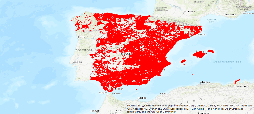
IGME Water Point Database
Inventory of IGME aquifer points, with location data, nature, use and technical data of the drilling. Temporary coverage ranges from 1966 to the present. It contains the inventory of aquifer punctures of the IGME with situation data, nature, use, technical data of the drilling, crossed lithologies, temporary measures of chemical analysis, piezometry, flow rates, pumping tests and possible associated documents.
Simple
- Alternate title
-
Water Points. Aquifer points. Water Base
- Date (Creation)
- 1970-01-01
- Citation identifier
- IGME-CSIC / ESPIGMEPUNTOSAGUA
- Purpose
-
The Water Database was created in the 70s, with the objective of covering the need for simple and fast storage and handling of the large volume of data in relation to knowledge of the underground aquifers of Spain, its hydraulic potential and quality of its waters, which began to be generated in the IGME, mainly from the Underground Water Research Plans (PIAS) and Aquifer Management and Conservation (PGCA) and Urban Nucleus Supply (PANU).
With the creation of this mechanized file that facilitates the selective access and use of this data, the loss of information was avoided by storing the data of the geographic-administrative, technical, hydrogeological and geographic parameters in a single location.
hydrochemicals, obtained over time in all studies and research of the different river basins carried out in the IGME. Likewise, the consultation of this information was facilitated to the different Organisms of the administration, both central and Autonomous, private companies and individuals..
- Credit
-
Miguel Mejías Moreno
- Status
- On going
- Point of contact
-
Organisation name Individual name Electronic mail address Role Geological Survey of Spain (IGME-CSIC)
Miguel Mejías Moreno
Point of contact
- Maintenance and update frequency
- Not planned
- Keywords
-
-
IGME
-
WATER
-
Water Points
-
Chemical analysis
-
Piezometric Levels
-
Levels
-
Flow rates
-
IDEE
-
-
IGME Thesaurus
-
-
Groundwater
-
Hydrometry
-
Pump tests
-
lithology
-
Spain
-
- Keywords
-
-
EGDI
-
- Keywords
-
-
EGDI-selection
-
- Specific usage
-
This mechanized file facilitates the selective access and use of these data avoiding the loss of information by storing in a single location the data of the geographic-administrative, technical, hydrogeological and hydrochemical parameters, obtained over time in all studies and research of the different river basins carried out in the IGME. It also facilitates the consultation of this information to the different central and regional administration agencies, private companies and individuals.
- User contact info
-
Organisation name Individual name Electronic mail address Role Geological Survey of Spain (IGME-CSIC)
Point of contact
- Access constraints
- Other restrictions
- Other constraints
- No Limitations on public acces
- Use constraints
- Other restrictions
- Other constraints
-
LICENCE OF USE: Conditions of public use and dissemination of information for the re-use of IGME data. https://www.igme.es/condiciones-de-uso/
- Spatial representation type
- Vector
- Denominator
- 50000
- Denominator
- 25000
- Language
- Spanish; Castilian
- Character set
- UTF8
- Topic category
-
- Geoscientific information
))
- Extent type code
- Yes
- Geographic identifier
- ES
- Unique resource identifier
- EPSG:4326
- Unique resource identifier
- EPSG:4258
- Unique resource identifier
- EPSG:4230
- Unique resource identifier
- EPSG:23028
- Unique resource identifier
- EPSG:23029
- Unique resource identifier
- EPSG:23030
- Unique resource identifier
- EPSG:23031
- Unique resource identifier
- EPSG:25828
- Unique resource identifier
- EPSG:25829
- Unique resource identifier
- EPSG:25830
- Unique resource identifier
- EPSG:25831
- Unique resource identifier
- EPSG:3857
- Unique resource identifier
- EPSG:102100
- Distribution format
-
Name Version Shapefile - SHP
No se aplica
Web Map Service WMS
1.3.0
Distributor
- Distributor contact
-
Organisation name Individual name Electronic mail address Role Technical Vice-Directorate of Geological Information Systems of the Geological Survey of Spain (IGME-CSIC)
Distributor
- Fees
-
Distribución a través de la web
- Distributor format
-
Name Version Joint Photographic Group Format JPEG
No se aplica
Web Map Service WMS
1.3.0
- OnLine resource
-
Protocol Linkage Name Servicio de visualización WMS de la Base de Puntos de Agua del IGME
http://mapas.igme.es/gis/services/BasesDatos/IGME_PuntosAgua/MapServer/WMSServer?REQUEST=GetCapabilities&SERVICE=WMS WWW:LINK-1.0-http--link
http://info.igme.es/BDAguas/ IGME Water Point Base Download
- Hierarchy level
- Dataset
Conformance result
Conformance result
- Title
-
COMMISSION REGULATION (EC) No 1205/2008 of 3 December 2008 implementing Directive 2007/2/EC of the European Parliament and of the Council as regards metadata
- Date (Publication)
- 2008-12-04
- Explanation
-
Consult the regulations
- Pass
- Yes
- Statement
-
The Water Database was created in the 1970s, with the aim of covering the need for simple and rapid storage and handling of the large volume of data in relation to knowledge of Spain's underground aquifers, their hydraulic potential and the quality of their waters, which were beginning to be generated in the IGME, fundamentally from the Groundwater Research Plans (PIAS) and Aquifer Management and Conservation Plans (PGCA) and Urban Core Supply (PANU).
The Water Database, in all these years, in line with the progress of the technology, has gone through different computer equipment, operating systems and database managers.
- Description
-
Initially the main sources of information were the Groundwater Research Plans (PIAS) and Aquifer Management and Conservation Plans (PGCA) and Urban Core Supply (PANU). Currently, the sources of work that incorporate information to the base are the hydrogeological research projects that are being developed in the IGME, with no scheduled update frequency.
- Title
-
IGME Water Points Database
- Date (Creation)
- 1970-01-01
- Cited responsible party
-
Organisation name Individual name Electronic mail address Role Geological Survey of Spain (IGME-CSIC)
Mejías Moreno, Miguel
Point of contact Geological Survey of Spain(IGME-CSIC)
Mejías Moreno, Miguel
Distributor
- Presentation form
- Digital document
Metadata
- File identifier
- ESPIGMEPUNTOSAGUA20190723 XML
- Metadata language
- Spanish; Castilian
- Character set
- UTF8
- Hierarchy level
- Dataset
- Date stamp
- 2026-05-22T12:49:03.646128Z
- Metadata standard name
-
Reglamento (CE) Nº 1205/2008 de Inspire, "Perfil IGME"
- Metadata standard version
-
2.0
- Metadata author
-
Organisation name Individual name Electronic mail address Role Geological Survey of Spain (IGME-CSIC)
Leticia Vega Martín
Point of contact
- Other language
-
Language Character encoding English UTF8 Spanish; Castilian UTF8
)))