 Catalogo de metadatos IGME-CSIC
Permeability Map of Spain at scale 1:200.000 digital continuous
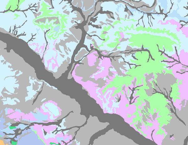
The continuous and digital Permeability Map of Spain at a scale of 1:200.000000 is based on the continuous Lithostratigraphic Map of Spain at a scale of 1:200.000 and represents the mapped lithostratigraphic levels grouped by similar permeability values.
In order to carry it out, firstly, a legend was drawn up in which a degree of permeability was assigned to each mapped lithostratigraphic unit. Five types of permeability were established: Very high, High, Medium, Low and Very low. The different lithologies were associated into 7 large groups (carbonate, detrital, Quaternary detrital, volcanic, metadetritic, igneous and evaporitic), giving rise to a classification by types of aquifers, established according to the formation processes of each permeability.
This map clearly shows the hydrogeological domains with a predominance of calcareous and evaporitic, detritic and crystalline aquifers, highlighting the main peninsular and island structural lines that bring the different groundwater bodies defined into contact with each other.
This cartography is adapted to the hydrographic network and the shadow model produced by CEDEX, at a scale of 1:200,000, based on the topographic base, at a scale of 1:50,000, of the Army Cartographic Service. The cartographic information is referenced to coordinates in UTM projection, European Datum, zone 30, except for that corresponding to the Canary Islands, which is referenced to zone 28.
The map is made up of the Cartographic Units Information Layer (LPIT) and the external table
dat table, which assigns to each lithostratigraphic formation (FH) the degree of permeability as well as the colour of representation.
The format of the generated information is Shape file.
Simple
- Alternate title
-
Permeability 200 digital continuous
- Date (Creation)
- 2005-09-18
- Date (Publication)
- 2007-09-30
- Date (Revision)
- 2009-08-05
- Edition
-
2ª edición
- Edition date
- 2009-01-01
- Citation identifier
- 637842
- Presentation form
- Hardcopy document
- Presentation form
- Hardcopy map
- Presentation form
- Digital document
- Presentation form
- Digital map
- Purpose
-
The Permeability Map allows the representation of the hydrogeological information at a scale of 1:200,000 for most of the groundwater bodies defined. In the case of small bodies of groundwater, although this scale of representation may present disadvantages in terms of definition, it does allow a certain amount of detail to show their hydrogeological functioning and to be able to programme detailed studies when necessary.
The continuous lithostratigraphic and permeability map of Spain, at a scale of 1:200,000, is produced by means of a "Collaboration Agreement between the Ministry of the Environment (General Secretariat for Territory and Biodiversity. Directorate General for Water) and the Geological and Mining Institute of Spain for the performance of technical work in relation to the application of the Water Framework Directive on groundwater" signed in 2004, and is the basis for the preparation of the Hydrogeological Map of Spain at a scale of 1:200,000 continuous and in digital format.
- Credit
-
Author, co-author(s) or organisation(s) and Type of aid
Director, coordinator of the project: Miguel del Pozo Gómez ( IGME )
Supervisors:
IGME technical-scientific staff.
Contributors:
REMAIN technical-scientific staff ( zone 1).
Technical-scientific staff of TECNA (zone 2 )
Technical-scientific staff of CGS (zone 3 )
Technical-scientific staff of EPTISA (zone 4 )
Technical-scientific staff of AURENSIS (zone 5 )
Technical-scientific staff of INYPSA (zone 6 )
Technical-scientific staff of INTECSA (zone 7 )
Technical-scientific staff of INIMA (zone 8)
IDRENA technical-scientific staff (zone 9)
Technical-scientific staff of BIOSFERA XXI ( zone 10 )
Carried out through a collaboration agreement between the Ministry of the Environment and the IGME.
- Status
- Completed
- Point of contact
-
Organisation name Individual name Electronic mail address Role Geological Survey of Spain (IGME-CSIC)
Mejías Moreno, Miguel
Point of contact
- Maintenance and update frequency
- Not planned
-
Tesauro IGME
-
-
Stratigraphy.lithostratigraphy
-
Stratigraphy.lithostratigraphy
-
Hydrology, Hydrogeology, Hydrogeology.
-
-
CEOLocation
-
-
COUNTRIES.SPAIN
-
- Keywords
-
-
Chronostratigraphy
-
- Keywords
-
-
Permeability
-
- Keywords
-
-
groundwater
-
- Keywords
-
-
WFD
-
- Keywords
-
-
Groundwater body
-
- Keywords
-
-
Aquifer
-
-
GEMET
-
-
NATURAL ENVIRONMENT, ANTHROPIC ENVIRONMENT
-
HYDROSPHERE (freshwater, seawater, waters)
-
hydrosphere
-
water (geography)
-
groundwater
-
- Keywords
-
-
EGDI
-
- Specific usage
-
The Permeability Map of Spain at a scale of 1:200,000 continuous digital is the starting point for the elaboration of the Hydrogeological Map of Spain at a scale of 1:200,000 continuous digital. Its objective is to contribute to compliance with the Water Framework Directive.
- User contact info
-
Organisation name Individual name Electronic mail address Role Geological Survey of Spain (IGME-CSIC)
Point of contact
- Access constraints
- Other restrictions
- Other constraints
- No limitations on public access.
- Use constraints
- Other restrictions
- Other constraints
-
LICENCE OF USE: Conditions of public use and dissemination of information for the re-use of IGME data. https://www.igme.es/condiciones-de-uso/
- Title
-
Hydrogeological Map of Spain at a scale of 1:200,000, continuous
- Date (Publication)
- 2009-08-05
- Cited responsible party
-
Organisation name Individual name Electronic mail address Role Geological Survey of Spain (IGME-CSIC)
Point of contact
- Aggregate Datasetindentifier
- 637843
- Association Type
- Cross reference
- Title
-
Lithostratigraphic Map of Spain at a scale of 1:200.000, continuous
- Date (Publication)
- 2007-09-30
- Cited responsible party
-
Organisation name Individual name Electronic mail address Role Geological Survey of Spain (IGME-CSIC)
Point of contact
- Aggregate Datasetindentifier
- 637841
- Association Type
- Larger work citation
- Spatial representation type
- Vector
- Denominator
- 200000
- Language
- Spanish; Castilian
- Character set
- 8859 Part 1
- Topic category
-
- Geoscientific information
))
- Supplemental Information
-
The document "Preparation of the hydrogeological map of Spain at a scale of 1:200,000, continuous and in digital format" (2009) can be consulted in the Documentation Service, where the process of preparation and description of the information prepared is described in detail.
There is an application for distribution on DVD, published in 2007, which contains the geological and cartographic information, tables, symbology libraries and map compositions. It has a consultation application and a map viewer.
The Permeability Map of Spain at a scale of 1:200,000 can be viewed and consulted in the Groundwater Information System (SIAS) of the Geological and Mining Institute of Spain (IGME-CSIC).
- Unique resource identifier
- EPSG:6230
- Unique resource identifier
- EPSG:23028
- Unique resource identifier
- EPSG:23030
- Unique resource identifier
- EPSG:4258
- Distribution format
-
Name Version Mapa digital: JPEG -Joint Photographic Group Format
-
Mapa digital: SHP - ArcView ShapeFile
8.3.0.800
Mapa digital: PDF - Portable Document Format
-
Mapa en papel
-
Servicio web: WMS - Web Map Service
-
Distributor
- Distributor contact
-
Organisation name Individual name Electronic mail address Role Geological Survey of Spain (IGME-CSIC)
Distributor
- Distributor format
-
Name Version Mapa digital: JPEG -Joint Photographic Group Format
-
Mapa digital: SHP - ArcView ShapeFile
8.3.0.800
Mapa digital: PDF - Portable Document Format
-
Distributor
- Distributor contact
-
Organisation name Individual name Electronic mail address Role Documentation Centre of the Geological Survey of Spain (IGME-CSIC)
Distributor
- Distributor format
-
Name Version Mapa en papel
-
Distributor
- Distributor contact
-
Organisation name Individual name Electronic mail address Role Technical Vice-Directorate of Geological Information Systems of the Geological Survey of Spain (IGME-CSIC)
Distributor
- Distributor format
-
Name Version Servicio web: WMS - Web Map Service
1.3.0
- Units of distribution
-
Unidades cartográficas (LPLIT): Recintos poligonales litológicos con las unidades cartográficas codificadas según el campo FH. Cada recinto o polígonos tiene un códigos numérico correspondiente a la formación geológica según la columna litoestratigráfica (FH). La descripción litológica completa, la descripción geocronológica y la clasificación de permeabilidad se almacenan en una tabla externa (Tabla litperm.dat) que tiene un registro por cada formación litoestratigráfica en el mapa. Para favorecer la utilización y correcta simbolización de la información generada, se crea otra tabla externa (Perme.dat) que relaciona cada una de las formaciones (FH), con el color que se le debe asignar al realizar la composición de la leyenda y mapa de permeabilidades.
- OnLine resource
-
Protocol Linkage Name OGC:WMS-1.3.0-http-get-capabilities
http://mapas.igme.es/gis/services/Cartografia_Tematica/IGME_Permeabilidad_200/MapServer/WMSServer?Request=GetCapabilities&Service=WMS Link to the GetCapabilities of the web service hosting the product
WWW:LINK-1.0-http--related
http://mapas.igme.es/Servicios/default.aspx#IGME_Permeabilidad_200 Link to the product page on the IGME web site
- Name
- DVD
- Hierarchy level
- Dataset
Completeness commission
- Name of measure
-
Duplicate phenomena
- Measure description
-
Geometric and topological control using GIS application tools.
Conformance result
- Title
-
Geometric and topological control using GIS application tools
- Date (Revision)
- 2007-09-30
Citation identifier
- Explanation
-
Digital comparative validation and visual comparative check of the original map and the digitised map. Validation with error rate < 1%.
- Pass
- Yes
Completeness omission
- Name of measure
-
Lack of phenomena
- Measure description
-
Visual spot check and cross-checking of spatial information with attribute tables.
Conformance result
- Title
-
Visual spot check and cross-checking of spatial information with attribute tables
- Date (Revision)
- 2007-09-30
- Explanation
-
Digital comparative validation and visual comparative check of the original map and the digitised map. Validation with error rate < 1%.
- Pass
- Yes
Conceptual consistency
- Name of measure
-
Degree of approximation of the digital data with the conceptual model. Distribution of phenomena in classes.
- Measure description
-
Manual verification
Conformance result
- Title
-
Modelo de datos de cartografía hidrogeológica a escala 1:200.000 en formato digital.
- Date (Revision)
- 2007-09-30
Citation identifier
- Explanation
-
Check that the digital information is consistent with the standards that conceptually define it. Consult the standard
- Pass
- Yes
Domain consistency
- Name of measure
-
Degree of approximation of the data to the established physical structure
- Measure description
-
Automatic verification
Conformance result
- Title
-
Specifications for the digitisation of hydrogeological mapping
- Date (Revision)
- 2007-09-30
Citation identifier
- Explanation
-
Check that the digital information is in accordance with the standards. Consult the standard
- Pass
- Yes
Non quantitative attribute accuracy
- Name of measure
-
Absence of errors in the assignment of values.
- Measure description
-
Comparative study with source information
Conformance result
- Title
-
Comparative study with source information
- Date (Revision)
- 2007-09-30
Citation identifier
- Explanation
-
Digital comparative validation and comparative visual check of the original map and the digitised map. Error rate 1%.
- Pass
- Yes
Format consistency
- Name of measure
-
Degree of approximation of the data to the established physical structure
- Measure description
-
Automatic verification.
Conformance result
- Title
-
Specifications for the digitisation of hydrogeological mapping
- Date (Revision)
- 2007-09-30
Citation identifier
- Explanation
-
Check that the digital information is in accordance with the standards. Consult the standard
- Pass
- Yes
Conformance result
- Date (Publication)
- 2010-12-08
Citation identifier
- Explanation
-
Consult the regulations
- Pass
- No
- Statement
-
The permeability map has been made on the basis of the information generated for the lithostratigraphic map of Spain at a scale of 1:200,000 continuous. From here, different processes are differentiated:
1.- Elaboration of a permeability legend that assigns a degree of permeability to each lithostratigraphic unit.
2.- Elaboration of the permeability map, in which the mapped lithostratigraphic levels with similar permeability values were grouped together.
- Description
-
Preparation of the legend of the permeability map:
Assignment of a degree of permeability for each lithostratigraphic unit mapped. According to the regulations for this mapping, five types of permeability were established: Very high, High, Medium, Low and Very low.
With these criteria, the legend of the Permeability Map was established as a double-entry graph showing on the abscissa axis the permeability ranges established and on the ordinate axis the lithologies associated with these permeability ranges. The different lithologies were associated in large groups giving rise to a classification by types of aquifers established according to the formation processes of each permeability. Finally, each type of aquifer was related to the usefulness of the water it contains. Each group established in this classification was represented with a specific colour and tone for its visualisation on the Permeability Map. Thus, carbonate rocks are represented in green, Quaternary detrital rocks are represented in grey, detrital lithologies are represented in blue, volcanic rocks in purple, meta-detritic rocks in red, igneous rocks in violet tones and evaporitic rocks in brown. All these groups reserve the lighter shades for the less permeable lithologies.
- Description
-
Preparation of the permeability map:
With the representation criteria indicated above in the legend and taking into account that each lithostratigraphic unit was assigned a degree of permeability, the Map of Permeabilities was made in which the mapped lithostratigraphic levels presenting similar permeability values were grouped together.
This map clearly shows the hydrogeological domains with a predominance of calcareous and evaporitic, detritic and crystalline aquifers, highlighting the main peninsular and insular structural lines that bring the different groundwater bodies defined into contact with each other.
- Description
-
Computer processing:
Integration of all the information in a Geographic Information System, establishing criteria on the characteristics of the data and its scope.
- Denominator
- 200000
- Title
-
Lithostratigraphic Map of Spain at a scale of 1:200.000 continuous
- Date (Publication)
- 2007-09-30
- Cited responsible party
-
Organisation name Individual name Electronic mail address Role IGME
Originator IGME
Distributor
- Presentation form
- Digital document
- Presentation form
- Digital table
Metadata
- File identifier
- ESPIGMEPERMEABILIDADES200CONTINUODIGITAL20100805637842 XML
- Metadata language
- Spanish; Castilian
- Character set
- UTF8
- Hierarchy level
- Dataset
- Date stamp
- 2025-05-16T13:27:46.872841Z
- Metadata standard name
-
Reglamento (CE) Nº 1205/2008 de INSPIRE
- Metadata standard version
-
TG 2.0
- Metadata author
-
Organisation name Individual name Electronic mail address Role Geological Survey of Spain (IGME-CSIC)
Leticia Vega Martín
Point of contact
- Other language
-
Language Character encoding English UTF8 Spanish; Castilian UTF8
)))