 Catalogo de metadatos IGME-CSIC
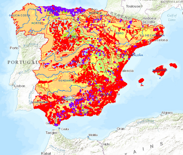
Permeability Map of Spain at a scale of 1:1,000,000, 1991.
The Permeability Map of Spain at a scale of 1:1,000,000 is the Hydrogeological Map of Spain at a scale of 1:1,000,000, classified according to permeability. Permeability is represented by colours, while lithostratigraphy or hydrogeology is represented by symbolisation of the materials.
It is a synthesis of the permeable hydrogeological formations and aquifers at national level, resulting from the systematic studies carried out by the IGME until 1991 on the hydrogeological characteristics of the territory of Spain, determining the location of the aquifers, evaluating their degree of exploitation, hydrodynamic characteristics, resources and reserves, and the quality and contamination of their waters.
The map has been drawn up by the Geological Survey of Spain in compliance with its specific functions.
It covers the national territory of the Iberian Peninsula, the Balearic Islands and the Canary Islands.
The first edition of the Hydrogeological Map of Spain at a scale of 1:1,000,000 corresponds to 1991.
A second edition was produced in 1999, incorporating the Hydrogeological Units of Spain into the hydrogeological map.
Simple
- Alternate title
-
Permeability1M
- Date (Creation)
- 1990-01-01
- Date (Publication)
- 1991-01-01
- Date (Revision)
- 1999-01-01
- Edition
-
2ª Edición
- Edition date
- 1999-01-01
- Citation identifier
- 621982
- Presentation form
- Digital map
- Purpose
-
This map aimed to present in a global and standardised way (UNESCO, IAH), the hydrogeological characteristics of the geological formations and the spatial distribution of the different types of aquifers. It is a synthesis of the national hydrogeological knowledge updated up to 1991.
- Credit
-
Authors:
Segismundo Niñerola Pla (Compañía General de Sondeos)
Alberto Marín Marín (Compañía General de Sondeos)
Supervisors:
Jesús Gómez de las Heras (IGME-CSIC)
Jorge Porras Martín (IGME-CSIC)
Miguel del Pozo Gómez (IGME-CSIC)
Contributors:
Javier Almogera Lucena (Compañía General de Sondeos)
Armando Ballester Rodríguez (IGME-CSIC)
Francisco carreras Suárez (Compañía General de Sondeos)
José Corominas Blanch (Compañía General de Sondeos)
Alejandro García Villar (Compañía General de Sondeos)
Jesús Gómez de las Heras (IGME-CSIC)
Ángel González Asensio (IGME-CSIC)
Luis López Vilches (Compañía General de Sondeos)
Tomás Rodríguez Estrella (Empresa Nacional de Investigación Minera SA)
Luis Virgós Soriano (Compañía General de Sondeos)
- Status
- Completed
- Point of contact
-
Organisation name Individual name Electronic mail address Role Geological Survey of Spain (IGME-CSIC) Mejías Moreno, Miguel
Point of contact
- Maintenance and update frequency
- Not planned
-
IGME Thesaurus
-
-
Hydrology, Hydrogeology
-
Hydrology, Hydrogeology, Hydrogeology.hydrogeological map
-
Physical and chemical properties.property.property.physical property.permeability
-
Hydrology, Hydrogeology.aquifer
-
General geology.geology
-
-
CEOLocation
-
-
COUNTRIES.SPAIN
-
- Keywords
-
-
Hydrogeological formations
-
Hydrogeological mapping
-
Aquifer formations
-
-
GEMET
-
-
NATURAL ENVIRONMENT, ANTHROPIC ENVIRONMENT
-
HYDROSPHERE (freshwater, seawater, waters)
-
hydrosphere
-
water (geography)
-
groundwater
-
- Specific usage
-
The Permeability Map of Spain at a scale of 1:1,000,000 is mainly used for general works related to groundwater. It also has a clear didactic interest as it presents a global vision of the distribution of hydrogeological formations and aquifers.
- User contact info
-
Organisation name Individual name Electronic mail address Role Geological Survey of Spain (IGME-CSIC) Point of contact
- Access constraints
- Other restrictions
- Other constraints
- No limitations on public access
- Use constraints
- Other restrictions
- Other constraints
-
LICENCE OF USE: Conditions of public use and dissemination of information for the re-use of IGME data. https://www.igme.es/condiciones-de-uso/
- Title
-
Lithostatrigraphic map of Spain at a scale of 1:200.000, continuous
- Date (Publication)
- 2007-09-30
- Cited responsible party
-
Organisation name Individual name Electronic mail address Role Geological Survey of Spain (IGME-CSIC) Point of contact
- Aggregate Datasetindentifier
- 637841
- Association Type
- Larger work citation
- Title
-
Permeability Map of Spain at a scale of 1:200.000, continuous
- Date (Publication)
- 2007-09-30
- Cited responsible party
-
Organisation name Individual name Electronic mail address Role Geological Survey of Spain (IGME-CSIC) Point of contact
- Aggregate Datasetindentifier
- 637842
- Association Type
- Larger work citation
- Title
-
Hydrogeological Map of Spain at scale 1:200.000
- Date (Publication)
- 2009-08-05
- Cited responsible party
-
Organisation name Individual name Electronic mail address Role Geological Survey of Spain (IGME-CSIC) Point of contact
- Aggregate Datasetindentifier
- 637843
- Association Type
- Cross reference
- Title
-
Hydrogeological map of Spain at scale 1:1.000.000
- Date (Publication)
- 1991-01-01
- Cited responsible party
-
Organisation name Individual name Electronic mail address Role Geological Survey of Spain (IGME-CSIC) Point of contact
- Aggregate Datasetindentifier
- 621981
- Association Type
- Cross reference
- Spatial representation type
- Vector
- Denominator
- 1000000
- Language
- Spanish; Castilian
- Character set
- 8859 Part 1
- Topic category
-
- Geoscientific information
- Description
-
Spain
))
- Supplemental Information
-
Publication of the Hydrogeological Map of Spain at a scale of 1:1.000.000 of 1991, (Publications: reference 0306/12, 1991). The publication consists of a map and a report.
In the IGME's Cartoteca catalogue it is recorded under the reference number II/3-6-7/8/9.
In the year 2000 another publication was made, whose reference in IGME Publications is 0306/18 with ISBN 84-7840-389-2. It consists of the Hydrogeological map of Spain at a scale of 1:1,000,000, incorporating the Hydrogeological Units of Spain, a report and CD-ROM. In the IGME Cartoteca catalogue, it appears under the reference number IV/14-2-15/16.
- Unique resource identifier
- EPSG:6230
- Unique resource identifier
- EPSG:23030
- Unique resource identifier
- EPSG:4728 Pico de las Nieves / UTM zona 28
- Unique resource identifier
- EPSG:4258
- Distribution format
-
Name Version Mapa digital: SHP - ArcView ShapeFile
8.3.0.800
Mapa digital: PDF - Portable Document Format
Unknown
Mapa digital: JPEG -Joint Photographic Group Format
Unknown
Mapa en papel
Unknown
Servicio web: WMS - Web Map Service
1.3.0
Distributor
- Distributor contact
-
Organisation name Individual name Electronic mail address Role Geological Survey of Spain (IGME-CSIC) Distributor
- Distributor format
-
Name Version Mapa digital: SHP - ArcView ShapeFile
8.3.0.800
Mapa digital: PDF - Portable Document Format
-
Mapa digital: JPEG -Joint Photographic Group Format
-
Distributor
- Distributor contact
-
Organisation name Individual name Electronic mail address Role Documentation Centre
Distributor
- Distributor format
-
Name Version Mapa en papel
-
Distributor
- Distributor contact
-
Organisation name Individual name Electronic mail address Role Geological Information Systems Area
Distributor
- Distributor format
-
Name Version Servicio web: WMS - Web Map Service
1.3.0
- Units of distribution
-
El mapa de Permeabilidades de España está compuesto por dos ficheros espaciales: uno con los datos de la península ibérica e islas Baleares y otro con los datos de las islas Canarias.
- OnLine resource
-
Protocol Linkage Name OGC:WMS-1.1.1-http-get-capabilities
http://mapas.igme.es/gis/services/eWater/IGME_Permeabilidad_1M/MapServer/WMSServer?Request=GetCapabilities&Service=WMS Link to the GetCapabilities of the web service hosting the product
WWW:LINK-1.0-http--related
http://mapas.igme.es/Servicios/default.aspx#IGME_Permeabilidad_1M Link to the product page on the IGME web site
- Name
- DVD
- Hierarchy level
- Dataset
Completeness commission
- Name of measure
-
Duplicate phenomena.
- Measure description
-
Geometric and topological control using GIS application tools.
Conformance result
- Title
-
Geometric and topological control using the tools of the GIS application.
- Date (Revision)
- 1991-01-01
Citation identifier
- Explanation
-
Digital comparative validation and visual comparative check of the original map and the digitised map. Validation with error rate < 1%.
- Pass
- Yes
Completeness omission
- Name of measure
-
Lack of phenomena.
- Measure description
-
Visual spot check and cross-checking of spatial information with attribute tables.
Conformance result
- Title
-
Visual spot check and cross-checking of spatial information with attribute tables.
- Date (Revision)
- 1991-01-01
Citation identifier
- Explanation
-
Digital comparative validation and visual comparative check of the original map and the digitised map. Validation with error rate < 1%.
- Pass
- Yes
Conceptual consistency
- Name of measure
-
Degree of approximation of the digital data with the conceptual model. Distribution of phenomena in classes
- Measure description
-
Manual verification.
Conformance result
- Title
-
Hydrogeological mapping data model at a scale of 1:200,000 in digital format.
- Date (Revision)
- 1991-01-01
Citation identifier
- Explanation
-
Check that the digital information is consistent with the standards that conceptually define it. Consult the standard
- Pass
- Yes
Conceptual consistency
- Name of measure
-
Degree of approximation of the digital data with the conceptual model. Relationships between phenomena.
- Measure description
-
Manual verification
Conformance result
- Title
-
Hydrogeological mapping data model in digital format
- Date (Revision)
- 1991-01-01
Citation identifier
- Explanation
-
Check that the digital information is consistent with the standards that conceptually define it. Consult the standard
- Pass
- Yes
Format consistency
- Name of measure
-
Degree of approximation of the data to the established physical structure
- Measure description
-
Automatic verification.
Conformance result
- Title
-
Specifications for the digitisation of hydrogeological mapping.
- Date (Revision)
- 1991-01-01
Citation identifier
- Explanation
-
Check that the digital information is in accordance with the standards. Consult the standard
- Pass
- Yes
Thematic classification correctness
- Name of measure
-
Absence of errors in the assignment of classes to phenomena.
- Measure description
-
Comparative study with original map. Random sampling.
Conformance result
- Title
-
Comparative study with original map. Random sampling
- Date (Revision)
- 1991-01-01
Citation identifier
- Explanation
-
Digital comparative validation and visual comparative check of the original map and the digitised map. Validation with error rate of error < 1%.
- Pass
- Yes
Thematic classification correctness
- Name of measure
-
Absence of errors in the assignment of identifiers to cartographic units
- Measure description
-
Comparative study with original map
Conformance result
- Title
-
Comparative study with original map
- Date (Revision)
- 1991-01-01
Citation identifier
- Explanation
-
Digital comparative validation and comparative visual check of the original map and the digitised map. Error rate < 1%. Error area < 0.1% in map units.
- Pass
- Yes
Non quantitative attribute accuracy
- Name of measure
-
Absence of errors in the assignment of values
- Measure description
-
Comparative study with original map
Conformance result
- Title
-
Comparative study with original map
- Date (Revision)
- 1991-01-01
Citation identifier
- Explanation
-
Digital comparative validation and comparative visual check of the original map and the digitised map. Error rate < 1%. Error area < 0.1% in map units.
- Pass
- Yes
Conformance result
Conformance result
- Title
-
COMMISSION REGULATION (EC) No 1205/2008 of 3 December 2008 implementing Directive 2007/2/EC of the European Parliament and of the Council as regards metadata
- Date (Publication)
- 2008-12-04
- Explanation
-
Consult the regulation
- Pass
- Yes
Conformance result
- Statement
-
The original map is the Hydrogeological Map of Spain at scale 1:1.000.000 published in 1991. The map of Permeabilities of Spain at a scale of 1:1,000,000 is the hydrogeological map classified according to permeability. Permeability is represented by colours, while lithostratigraphy or hydrogeology is represented by symbolisation of the materials.
It is a synthesis of the permeable hydrogeological formations and aquifers at national level, resulting from the systematic studies carried out by the IGME-CSIC until 1991 on the hydrogeological characteristics of the Spanish territory, determining the location of the aquifers, evaluating their degree of exploitation, hydrodynamic characteristics, resources and reserves, and the quality and contamination of their waters.
The map has been prepared by the Geological Survey of Spain (IGME-CSIC) in compliance with its specific functions.
The main sources were:
Geological Map of the Iberian Peninsula, Balearic and Canary Islands at a scale of 1:1,000,000. IGME (1980)
Geological Map of Spain at a scale of 1:200,000. Synthesis of existing cartography. IGME
Groundwater Research Plan, Aquifer Management and Conservation Programme and Urban Water Supply Plan. IGME
Hydrogeological Map of Spain at a scale of 1:50.000 and 1:200.000. IGME
National Archive of Water Points. IGME
International Hydrogeological Map of Europe, scale 1:1.500.000. UNESCO-IAH Maps and Memories
Yearbooks of gauging. DGOH, MOPU
Hydrological Plan. MOPU and other Ministries
Various publications on hydrogeology and other specific sources as well as theses and dissertations from different universities.
The digitalisation process of the map and the legend was carried out in 1999 from the printing plates, generating the corresponding coverages in ArcInfo format.
In 1999 the Hydrogeological Map of Spain was republished on paper at a scale of 1:1,000,000, incorporating the Hydrogeological Units of Spain.
- Description
-
Gathering information
- Description
-
Elaboration of the general legend
- Description
-
Digitisation: Digitisation of the map and legend from the printing plates.
Metadata
- File identifier
- ESPIGMEPERMEABILIDAD1M20100217621982 XML
- Metadata language
- Spanish; Castilian
- Character set
- UTF8
- Hierarchy level
- Series
- Hierarchy level name
-
Mapa de Permeabilidades de España a escala 1:1.000.000, 1991
- Date stamp
- 2026-05-22T11:21:03.221107Z
- Metadata standard name
-
Reglamento (CE) Nº 1205/2008 de Inspire, "Perfil IGME"
- Metadata standard version
-
2.0
- Metadata author
-
Organisation name Individual name Electronic mail address Role Geological Survey of Spain (IGME-CSIC) Leticia Vega Martín
Point of contact
- Other language
-
Language Character encoding English UTF8 Spanish; Castilian UTF8
)))