 Catalogo de metadatos IGME-CSIC
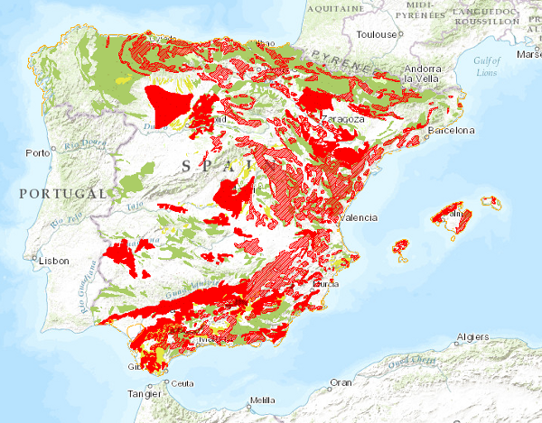
Spanish Land Movements Map at a scale of 1:1.000.000
Map delimiting the areas with different types of land movements, representing the most intense and frequent movements. It therefore shows the distribution and extent of the most problematic areas from a practical point of view. Land movements are classified into four main groups: horizontal component movements (landslides and landslides), vertical component movements (subsidence and subsidence, and expansive clays), unstable processes in coastal areas and movements related to mining operations. Areas with significant erosion processes are also included. This map, published in 1987, was drawn up entirely by staff of the Geological Survey of Spain in response to the need for information on geological hazards and risks on a national scale.
Simple
- Alternate title
-
Land Movements 1000
- Date (Creation)
- 1987-01-01
- Date (Publication)
- 1989-01-01
- Date (Revision)
- 2003-06-02
- Edition
-
1ª Edición
- Edition date
- 1987-01-01
- Citation identifier
- 01180
- Presentation form
- Hardcopy map
- Presentation form
- Digital map
- Presentation form
- Digital document
- Presentation form
- Hardcopy document
- Purpose
-
Land movements can affect society in different ways, endangering people's safety, destroying buildings or disabling infrastructures; they therefore constitute a geological risk. Spain, due to its rugged relief, climatic conditions and geological characteristics, is a country where this type of phenomena constitutes a real threat. The Spanish Land Movement Map at a scale of 1:1,000,000, in addition to constituting an inventory of spatial distribution, has been drawn up as a first-rate reference for territorial planning at national and regional level in terms of geological risks, allowing an effective approximation for more detailed studies.
- Credit
-
Instituto Geológico y Minero de España (Geological Survey of Spain): Organisation that has financed the production and publication of the map.
- Status
- Completed
- Point of contact
-
Organisation name Individual name Electronic mail address Role Instituto Geológico y Minero de España (IGME-CSIC)
Mulas de la Peña, Joaquín
Point of contact
- Maintenance and update frequency
- Not planned
-
INSPIRE_SpatialThemes
-
-
Natural Hazard Zones
-
-
IGME Thesaurus
-
-
General geology
-
slippage
-
Quaternary Geomorphology and Geology
-
mass movement
-
landslide
-
Structural geology
-
subsidence
-
-
CEOLocation
-
-
COUNTRIES
-
SPAIN
-
-
EuropeanTerritorialUnits
-
-
SPAIN
-
-
GEMET
-
-
NATURAL ENVIRONMENT, ANTHROPIC ENVIRONMENT
-
LITHOSPHERE (soil, geological processes)
-
geological processes
-
- Keywords
-
-
EGDI
-
- Specific usage
-
It is a national map, at a scale of 1:1,000,000, so its use is limited by scale, i.e. it should be used for national planning as an approximation for regional studies related to recent and current geological dynamics, research and territorial planning.
- User contact info
-
Organisation name Individual name Electronic mail address Role Instituto Geológico y Minero de España (IGME-CSIC)
Point of contact
- Access constraints
- Other restrictions
- Other constraints
- No limitations on public access.
- Use constraints
- Other restrictions
- Other constraints
-
LICENCE OF USE: Conditions of public use and dissemination of information for the re-use of IGME data. http://www.igme.es/Ayuda/CondiUso.htm
- Spatial representation type
- Vector
- Denominator
- 1000000
- Language
- Spanish; Castilian
- Character set
- 8859 Part 1
- Topic category
-
- Geoscientific information
))
- Supplemental Information
-
Memoria explicativa en formato papel.
- Title
-
European Petroleum Surgey Group
- Date (Creation)
- 1986-01-01
- Unique resource identifier
- EPSG:23030
- Title
-
European Petroleum Surgey Group
- Date (Creation)
- 1986-01-01
- Unique resource identifier
- EPSG:4728
- Unique resource identifier
- EPSG:4258
- Distribution format
-
Name Version Mapa digital: SHP - ArcView ShapeFile
Unknown
Mapa digital: PDF - Portable Document Format
Unknown
Mapa digital: ARCC - Coverage of Arc-Info
Unknown
Mapa digital: ARCE - ARC/INFO Export format
Unknown
Mapa en papel
Unknown
Servicio web: WMS - Web Map Service
1.3.0
Distributor
- Distributor contact
-
Organisation name Individual name Electronic mail address Role Instituto Geológico y Minero de España (IGME-CSIC)
Distributor
- Fees
-
60 euros. En la página http://www.igme.es/internet/servicios/S30C-109061610100.pdf se encuentra la Resolución de precios públicos del IGME en la que indican ciertos tipos de descuentos .
- Distributor format
-
Name Version Mapa digital: SHP - ArcView ShapeFile
-
Mapa digital: PDF - Portable Document Format
-
Mapa digital: ARCC - Coverage of Arc-Info
-
Mapa digital: ARCE - ARC/INFO Export format
-
Distributor
- Distributor contact
-
Organisation name Individual name Electronic mail address Role Centro de Documentación del Instituto Geológico y Minero de España (IGME-CSIC)
Distributor
- Distributor format
-
Name Version Mapa en papel
-
Distributor
- Distributor contact
-
Organisation name Individual name Electronic mail address Role Vicedirección Técnica de Sistemas de Información Geológica del Instituto Geológico y Minero del España (IGME-CSIC)
Distributor
- Distributor format
-
Name Version Web Service: WMS - Web Map Service
1.3.0
- OnLine resource
-
Protocol Linkage Name OGC:WMS-1.3.0-http-get-capabilities
http://mapas.igme.es/gis/services/Cartografia_Tematica/IGME_MTerreno_1M/MapServer/WMSServer?Request=GetCapabilities&Service=WMS Link to the GetCapabilities of the web service hosting the product
WWW:LINK-1.0-http--related
https://info.igme.es/cartografiadigital/tematica/tematicossingulares.aspx Link to the product page on the IGME web site
- Name
- CDROM
- Hierarchy level
- Series
Completeness commission
- Name of measure
-
Phenomena that do not exist in the original cartography but do exist in the digital product.
- Measure description
-
Visual spot check and cross-checking of spatial information with attribute tables.
Conformance result
- Title
-
Visual spot check and cross-checking of spatial information with attribute tables
- Date (Revision)
- 1989-01-01
Citation identifier
- Explanation
-
Digital comparative validation and visual comparative check of the original map and the digitised map. Validation with error rate < 1%.
- Pass
- Yes
Completeness commission
- Name of measure
-
Duplicate phenomena
- Measure description
-
Geometric and topological control using GIS application tools.
Conformance result
- Title
-
Geometric and topological control using the tools of the GIS application.
- Date (Revision)
- 1989-01-01
Citation identifier
- Explanation
-
Error rate 0 %
- Pass
- Yes
Completeness omission
- Name of measure
-
Lack of phenomena
- Measure description
-
Visual spot check and cross-checking of spatial information with attribute tables.
Conformance result
- Title
-
Visual spot check and cross-checking of spatial information with attribute tables
- Date (Revision)
- 1989-01-01
Citation identifier
- Explanation
-
Digital comparative validation and visual comparative check of the original map and the digitised map. Validation with error rate < 1%.
- Pass
- Yes
Conceptual consistency
- Name of measure
-
Degree of approximation of the digital data with the conceptual model. Distribution of phenomena in classes.
- Measure description
-
Manual verification
Conformance result
- Title
-
MAGNA geological mapping data model in digital format.
- Date (Revision)
- 2012-02-01
Citation identifier
- Explanation
-
Check that the digital information is consistent with the standards that conceptually define it. Consult the standard
- Pass
- Yes
Conceptual consistency
- Name of measure
-
Degree of approximation of the digital data with the conceptual model. Properties of the phenomena
- Measure description
-
Automatic verification
Conformance result
- Title
-
MAGNA geological mapping data model in digital format.
- Date (Revision)
- 2012-02-01
Citation identifier
- Explanation
-
Check that the digital information is consistent with the standards that conceptually define it. Consult the standard
- Pass
- Yes
Format consistency
- Name of measure
-
Degree of approximation of the data to the established physical structure
- Measure description
-
Automatic verification
Conformance result
- Title
-
Specifications for the digitisation of MAGNA geological mapping.
- Date (Revision)
- 2012-02-01
Citation identifier
- Explanation
-
Check that the digital information is in accordance with the standards. Consult the standard
- Pass
- Yes
Absolute external positional accuracy
- Name of measure
-
External absolute accuracy
- Measure description
-
Mean square error in the map registration to digitise
Conformance result
- Title
-
Mean square error in the map registration to digitise
- Date (Revision)
- 1989-01-01
Citation identifier
- Explanation
-
Verification that the positional error is smaller than required by the scale of the map < 1500 m
- Pass
- Yes
Thematic classification correctness
- Name of measure
-
Absence of errors in the assignment of classes to phenomena.
- Measure description
-
Comparative study with original map. Random sampling
Conformance result
- Title
-
Data model of the MAGNA geological mapping in digital format. Specifications for the digitisation of MAGNA geological mapping.
- Date (Revision)
- 2012-02-01
Citation identifier
- Explanation
-
Digital comparative validation and visual comparative check of the original map and the digitised map. Validation with error rate < 1%.
- Pass
- Yes
Thematic classification correctness
- Name of measure
-
Absence of errors in the assignment of identifiers to cartographic units.
- Measure description
-
Comparative study with original map
Conformance result
- Title
-
Comparative study with original map
- Date (Revision)
- 1989-01-01
Citation identifier
- Explanation
-
Digital comparative validation and comparative visual check of the original map and the digitised map. Error rate 1%. Error area < 0.1% in cartographic units.
- Pass
- Yes
Non quantitative attribute accuracy
- Name of measure
-
Accuracy of non-quantitative attributes: absence of errors in the assignment of values.
- Measure description
-
Comparative study with original map.
Conformance result
- Title
-
Comparative study with original map
- Date (Revision)
- 1989-01-01
Citation identifier
- Explanation
-
Digital comparative validation and comparative visual check of the original map and the digitised map. Error rate 1%. Error area < 0.1% in cartographic units.
- Pass
- Yes
Quantitative attribute accuracy
- Name of measure
-
Accuracy of quantitative attributes: absence of errors in the assignment of values.
- Measure description
-
Comparative study with original map.
Conformance result
- Title
-
Comparative study with original map
- Date (Revision)
- 1989-01-01
Citation identifier
- Explanation
-
Digital check of digital information. Error rate 1%. Error area < 0.1% in cartographic units.
- Pass
- Yes
Conformance result
Conformance result
Conformance result
- Date (Publication)
- 2010-12-08
Citation identifier
- Explanation
-
Consult the regulations
- Pass
- No
- Statement
-
The map was drawn up from the compilation of cartographic information at scales 1:25,000, 1:50,000 and 1:200,000 produced by the IGME, unpublished cartography, Doctoral Theses, Dissertations and other published works.
Subsequently, the phenomena to be included in the cartography were established and the legend of surface formations was drawn up. Next, the processes of synthesis, reclassification, generalisation and exaggeration were carried out for the final production of the map.
The digitisation process was carried out in 1991 from the printing plates and the definitive normalisation and generation of symbolised files (.lyr) and cartography, in version 8.3 of ArcGis, in 2003.
- Description
-
Bibliographic information; Topographic base. Geological and related maps at various scales. Climatic information.
- Description
-
Map preparation: Preparation of the land movements legend. Classification. Representation of point data. Determination of areas with current and potential movements according to the classification established from the information collected.
- Description
-
Digitisation:Inventory, selection and codification of cartographic phenomena. Digitisation, geometric treatment and symbolisation.
Association of attributes to spatial objects and creation of tables.
Checking of digital information, detection and correction of errors.
Metadata
- File identifier
- ESPIGMEMOVIMIENTOSTERRENO10002012012001180 XML
- Metadata language
- Spanish; Castilian
- Character set
- UTF8
- Hierarchy level
- Series
- Hierarchy level name
-
Mapa de Movimientos del Terreno de España a escala 1:1.000.000
- Date stamp
- 2025-05-12T10:22:52.322731Z
- Metadata standard name
-
Reglamento (CE) Nº 1205/2008 de Inspire, "Perfil IGME"
- Metadata standard version
-
2.0
- Metadata author
-
Organisation name Individual name Electronic mail address Role Instituto Geológico y Minero de España (IGME-CSIC)
Leticia Vega Martín
Point of contact
- Other language
-
Language Character encoding English UTF8 Spanish; Castilian UTF8
)))