 Catalogo de metadatos IGME-CSIC
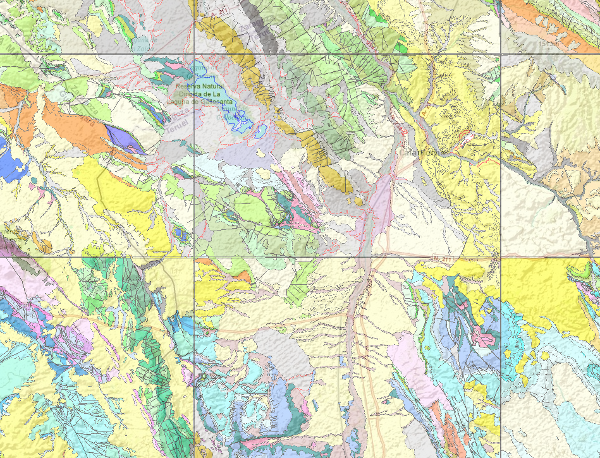
Geologic Map of Spain 1:50.000 scale, MAGNA
The National Geological Map (MAGNA), was made between 1972 and 2003 by the Geological Survey of Spain, is distributed in sheets 1: 50.000 (1: 25.000 in particular cases of the Canary Islands, Ibiza-Formentera, Menorca, Ceuta and Melilla). The geological map shows the nature of materials (rocks and sediments) that appear on the surface, their spatial distribution and geometric relationships between the different cartographic units represented.
A geological mapping unit is the grouping of one or more lithologies with common age range, which is represented on the map at a scale or defined resolution. Each mapping unit, and the different geological structures, is represented on the map with a symbolism itself. The representation of these units on the topographic base map provides some three-dimensional information that is completed with other geological data and geological sections, stratigraphic profiles, polls, etc. The map legend is a pictogram representing the spatial relationship of the different mapping units (chronology, overlapping, geometric relationship, lateral facies changes, etc.). It also includes structural, hydrogeological and geological location of the sheet within the regional schemes.
Since 1991, the Geological Map Series MAGNA is made inseparably with the geomorphological map on the same scale. This map incorporates everything on the surface geology and provides a structured and accurate information of the land forms. It is organized on the basis of morphogenesis and morphocronology incorporated the map using the corresponding chronostratigraphic column included in a table / legend inspired by the geological map. The forms, erosional and depositional, are represented on the map by individualized by symbols and patterns of color and surface deposits or lithological formations elements that provide information.
For each sheet of the series MAGNA there is an explanatory report published, edited and in digital format.
The digital information is stored in coverage and Shape format (ESRI). There is a guide that describes the physical structure of the digital information and its codification.
Simple
- Alternate title
-
MAGNA 50
- Date (Creation)
- 1972-01-01
- Date (Publication)
- 1972-01-01
- Date (Revision)
- 1991-01-01
- Edition
-
2ª Serie
- Edition date
- 1972-01-01
- Citation identifier
- Código documento en el servicio de documentación: 20000
- Unique resource identifier
- ESPIGMEMAGNA50
- Codespace
-
IGME-CSIC
- Presentation form
- Hardcopy map
- Presentation form
- Hardcopy document
- Presentation form
- Digital document
- Presentation form
- Digital map
- Purpose
-
The Geological Map of Spain (MAGNA) 1: 50,000 scale (including geomorphological map) is part of the infrastructure of geoscientific knowledge for socio-economic development. Supports activities such as hydro-geological and mineral resources, public works, agriculture, land use, the environment territorial planning, natural hazards and generally any action on the physical environment that supports the decision-making actions on the territory.
- Credit
-
IGME is the institutional author of the series and its largest funder. The leaves are made by both IGME own staff and specialized service companies.
- Status
- Under development
- Point of contact
-
Organisation name Individual name Electronic mail address Role Geological Survey of Spain
Author
- Maintenance and update frequency
- Irregular
-
IGME Thesaurus
-
-
Geology
-
Estratigrafía.litoestratigrafía
-
Estratigrafía.cronoestratigrafía
-
Geología general.tectonita
-
Geomorfología y Geología del Cuaternario.geomorfología
-
Geomorfología y Geología del Cuaternario.morfogénesis
-
Geomorfología y Geología del Cuaternario.formación superficial
-
Geomorfología y Geología del Cuaternario.mapa geomorfológico
-
Geología general.mapa geológico
-
- Keywords
-
-
Spain
-
EGDI
-
InventoryGM
-
-
GEMET
-
-
NATURAL ENVIRONMENT, ANTHROPIC ENVIRONMENT
-
LITHOSPHERE (soil, geological processes)
-
lithosphere
-
rocks
-
- Specific usage
-
The Geological Map of Spain (MAGNA) at 1:50,000 scale, is used for all activities related to the hydrogeological and mineral resources, public works, agriculture, land use, land use planning, environment, risks natural and generally any action on the physical environment that supports the decision-making actions on the territory is a user of this mapping.
- User contact info
-
Organisation name Individual name Electronic mail address Role Geological Survey of Spain (IGME-CSIC)
Point of contact
- Use constraints
- Other restrictions
- Other constraints
-
LICENCE OF USE: Conditions of public use and dissemination of information for the re-use of IGME data. https://www.igme.es/condiciones-de-uso/
- Title
-
Geological Map of Spain 1:50.000 scale. Digital Edition
- Date (Revision)
- 1991-01-01
- Cited responsible party
-
Organisation name Individual name Electronic mail address Role Geological Survey of Spain (IGME-CSIC)
Point of contact
- Aggregate Datasetindentifier
- 30000
- Association Type
- Cross reference
- Spatial representation type
- Vector
- Denominator
- 50000
- Denominator
- 25000
- Language
- Spanish; Castilian
- Character set
- 8859 Part 1
- Topic category
-
- Geoscientific information
))
- Supplemental Information
-
Explanatory report
Implementing rules
Microscopic studies
Datings
- Title
-
European Petroleum Surgey Group
- Date (Creation)
- 1986-01-01
- Unique resource identifier
- EPSG:23030 (ED50 / UTM zone 30N)
- Unique resource identifier
- EPSG:4258
- Distribution format
-
Name Version Mapa digital: SHP - ArcView ShapeFile
-
Mapa digital: PDF - Portable Document Format
-
Mapa digital: ARCC - Coverage of Arc-Info
-
Mapa digital: ARCE - ARC/INFO Export format
-
Mapa en papel
-
Servicio web: WMS - Web Map Service
-
Mapa digital: JPG - Joint Photographic Experts Group
-
Mapa Digital: KML - Keyhole Markup Language
-
Distributor
- Distributor contact
-
Organisation name Individual name Electronic mail address Role Geological Survey of Spain (IGME-CSIC)
Distributor
- Distributor format
-
Name Version Mapa digital: SHP - ArcView ShapeFile
-
Mapa digital: PDF - Portable Document Format
-
Mapa digital: ARCC - Coverage of Arc-Info
-
Mapa digital: ARCE - ARC/INFO Export format
-
Distributor
- Distributor contact
-
Organisation name Individual name Electronic mail address Role Documentation Centre of the Geological Survey of Spain (IGME
Distributor
- Distributor format
-
Name Version Mapa en papel
-
Distributor
- Distributor contact
-
Organisation name Individual name Electronic mail address Role Technical Vice-Directorate of Geological Information Systems
Distributor
- Distributor format
-
Name Version WMS - Web Map Service
1.3.0.
- Units of distribution
-
La serie se distribuye en hojas a escala 1:50.00 o 1:25.000 y cada una de las hojas contiene los siguientes mapas: -. Mapa Geológico 1:50.000 -. Mapa Geomorfológico (tan solo en 1/3 de la serie) -. Memoria explicativa
- OnLine resource
-
Protocol Linkage Name https://mapas.igme.es/gis/services/Cartografia_Geologica/IGME_MAGNA_50/MapServer/WMSServer?Request=GetCapabilities&Service=WMS&Version=1.1.1 Enlace al GetCapabilities del servicio web donde se aloja el producto
WWW:LINK-1.0-http--related
http://info.igme.es/cartografiadigital/geologica/Magna3S.aspx?language=es Link to the product page in the IGME web
- Name
- DVD
- Hierarchy level
- Series
Completeness commission
- Name of measure
-
Phenomena that do not exist in the original cartography but do exist in the digital product
- Measure description
-
Visual spot check and cross-checking of spatial information with attribute tables
Conformance result
- Title
-
Visual spot check and cross-checking of spatial information with attribute tables
- Date (Revision)
- 1991-01-01
Citation identifier
- Explanation
-
Digital comparative validation and visual comparative check of the original map and the digitised map. Validation with error rate < 1%
- Pass
- Yes
Completeness commission
- Name of measure
-
Duplicate phenomena
- Measure description
-
Geometrical and topological control using the tools of the GIS application
Conformance result
- Title
-
Geometrical and topological control using the tools of the GIS application
- Date (Revision)
- 1991-01-01
Citation identifier
- Explanation
-
0% error rate
- Pass
- Yes
Completeness omission
- Name of measure
-
Lack of phenomena
- Measure description
-
Visual spot check and cross-checking of spatial information with attribute tables
Conformance result
- Title
-
Visual spot check and cross-checking of spatial information with attribute tables
- Date (Revision)
- 1991-01-01
Citation identifier
- Explanation
-
Digital comparative validation and visual comparative check of the original map and the digitised map. Validation with error rate < 1%
- Pass
- Yes
Conceptual consistency
- Name of measure
-
Degree of approximation of the digital data with the conceptual model. Distribution of phenomena in classes
- Measure description
-
Manual verification
Conformance result
- Title
-
MAGNA geological mapping data model in digital format.
- Date (Revision)
- 2012-02-01
Citation identifier
- Explanation
-
Check that the digital information is consistent with the standards that conceptually define it. Consult the standard
- Pass
- Yes
Conceptual consistency
- Name of measure
-
Degree of approximation of the digital data with the conceptual model. Properties of the phenomena
- Measure description
-
Automatic verification
Conformance result
- Title
-
MAGNA geological mapping data model in digital format
- Date (Revision)
- 2012-02-01
Citation identifier
- Explanation
-
Check that the digital information is consistent with the standards that conceptually define it. Consult the standard
- Pass
- Yes
Conceptual consistency
- Name of measure
-
Degree of approximation of the digital data with the conceptual model. Relationship between phenomena
- Measure description
-
Automatic verification
Conformance result
- Title
-
MAGNA geological mapping data model in digital format
- Date (Revision)
- 2012-02-01
Citation identifier
- Explanation
-
Check that the digital information is consistent with the standards that conceptually define it. Consult the standard
- Pass
- Yes
Domain consistency
- Name of measure
-
Existence of codes outside the established range for each attribute.
- Measure description
-
Automatic verification
Conformance result
- Title
-
Specifications for the digitisation of MAGNA geological mapping
- Date (Publication)
- 2012-02-01
Citation identifier
- Explanation
-
Check that the digital information is in accordance with the standards. Consult the standard
- Pass
- Yes
Format consistency
- Name of measure
-
Degree of approximation of the data to the established physical structure.
- Measure description
-
Automatic verification
Conformance result
- Title
-
Specifications for the digitisation of MAGNA geological mapping
- Date (Revision)
- 2012-02-01
Citation identifier
- Explanation
-
Check that the digital information is in accordance with the standards. Consult the standard
- Pass
- Yes
Absolute external positional accuracy
- Name of measure
-
External absolute accuracy
- Measure description
-
Mean square error in the map registration to digitise
Conformance result
- Title
-
Mean square error in the map registration to digitise
- Date (Revision)
- 1991-01-01
Citation identifier
- Explanation
-
Verification that the positional error is less than that required by the scale of the map < 40 m
- Pass
- Yes
Thematic classification correctness
- Name of measure
-
Absence of errors in the assignment of classes to phenomena.
- Measure description
-
Comparative study with original map. Random sampling
Conformance result
- Title
-
Data model of the MAGNA geological mapping in digital format. Specifications for the digitisation of MAGNA geological mapping
- Date (Revision)
- 2012-02-01
Citation identifier
- Explanation
-
Digital comparative validation and visual comparative check of the original map and the digitised map. Validation with error rate < 1%
- Pass
- Yes
Thematic classification correctness
- Name of measure
-
Ausencia de errores en la asignación de identificadores a las unidades cartográficas
- Measure description
-
Comparative study with original map. Random sampling
Conformance result
- Title
-
Comparative study with original map. Random sampling
- Date (Revision)
- 1991-01-01
- Explanation
-
Digital comparative validation and comparative visual check of the original map and the digitised map. Error rate 1%. Error area < 0.1% in cartographic units
- Pass
- Yes
Non quantitative attribute accuracy
- Name of measure
-
Accuracy of non-quantitative attributes: absence of errors in the assignment of values.
- Measure description
-
Comparative study with original map. Random sampling
Conformance result
- Title
-
Comparative study with original map. Random sampling
- Date (Revision)
- 1991-01-01
Citation identifier
- Explanation
-
Digital comparative validation and comparative visual check of the original map and the digitised map. Error rate 1%. Error area < 0.1% in cartographic units.
- Pass
- Yes
Quantitative attribute accuracy
- Name of measure
-
Accuracy of quantitative attributes: absence of errors in the assignment of values
- Measure description
-
Comparative study with original map. Random sampling
Conformance result
- Title
-
Comparative study with original map. Random sampling
- Date (Revision)
- 1991-01-01
Citation identifier
- Explanation
-
Digital check of digital information. Error rate 1%. Error area < 0.1% in cartographic units.
- Pass
- Yes
Conformance result
- Date (Publication)
- 2010-12-08
Citation identifier
- Explanation
-
Consult the regulation
- Pass
- No
Conformance result
Conformance result
- Title
-
Reglamento (CE) n.o 1205/2008 de la Comisión de 3 de Diciembre de 2008 que estabelece las modalidades de aplicación de la Directiva 2007/2/CE del Parlamento Europeo y del Consejo em materia de metadados
- Date (Publication)
- 2008-12-04
- Explanation
-
Consult the regulation
- Pass
- Yes
- Statement
-
The realization of this geological cartography is based on the geological information from the incomplete Geological Map of Spain scale 1: 50,000 (first series). In addition it collects and analyzes other information concerning the area and its environment, including bases and other topographic mapping and related work as singular projects, doctoral dissertations, etc.
The next step is the collection of data and samples for later study. After the transfer of field work to map, photo-interpretation work supported, and the final composition of the geological map.
This cartography is completed with the elaboration of the text of memory and organization and classification of additional information.
The digitization of the geological mapping information and normalization is in accordance with the Rules of digitization and Normalization defined by the IGME. Supervision, correction and validation also follow the procedure of digital mapping Review Institute. It consists of automatic controls error detection and correction, and thorough visual checks.
Finally cartographic composition and symbolized files (.lyr) in ArcGIS is performed.
- Description
-
Search, collection and analysis of previous information: bibliographic information, topographic base and digital terrain model, Geological Map of Spain 1: 50.000, First Series, aerial photographs and satellite images and other maps and previous documents.
- Description
-
Fieldwork: previous photo interpretation, verification and data collection in the field, sampling, re-photo interpretation and elaboration of the provisional map on the topographical base.
- Description
-
Realization of maps and Memory: drafting and drawing the final map. Study of analytical data. Elaboration of the text from memory. Collecting and organizing additional information.
- Description
-
Digitalization process : inventory, selection and encoding of the phenomena that comprise digital mapping. Digitization according to the specifications of the Institute. geometric treatment. Association attributes space objects and creating tables. Check digital information, error detection and correction. Verification of consistency between different digital maps.
- Description
-
The materials or rocks that appear on the surface of the sheet, their spatial distribution, nature and geometric relationships are represented. The cartographic units are groupings with common lithology and age formed by strata or other non-stratified rocks such as granites. The structural relationships between them are expressed by symbols, which gives the map a three-dimensional character that is completed with additional geological profiles that are the graphic expression of its geometry in depth. By means of symbology, information is added, some of an applied nature such as water points, deposits and mineral indications. This applied information is very important in the Series.
- Denominator
- 50000
- Title
-
Geological Map of Spain scale 1:50.000 MAGNA (1st serie)
- Date (Publication)
- 2500-01-01
- Cited responsible party
-
Organisation name Individual name Electronic mail address Role Geological Survey of Spain (IGME-CSIC)
Originator Geological Survey of Spain (IGME-CSIC)
Distributor
- Presentation form
- Hardcopy document
- Presentation form
- Hardcopy map
Metadata
- File identifier
- ESPIGMEMAGNA502010072320000 XML
- Metadata language
- Spanish; Castilian
- Character set
- UTF8
- Hierarchy level
- Series
- Hierarchy level name
-
Mapa Geológico de España Escala 1:50.000. MAGNA
- Date stamp
- 2026-05-22T11:06:29.189417Z
- Metadata standard name
-
ISO 19115 "Perfil IGME"
- Metadata standard version
-
2003 "1.0"
- Metadata author
-
Organisation name Individual name Electronic mail address Role Geological Survey of Spain (IGME-CSIC) Leticia Vega Martín
Point of contact
- Other language
-
Language Character encoding English Spanish; Castilian UTF8
)))