 Catalogo de metadatos IGME-CSIC
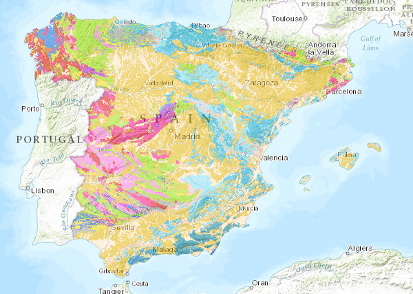
Lithological Map of the Iberian Peninsula, Balearic and Canary Islands at scale 1:1.000.000
The Lithological Map of the Iberian Peninsula, Balearic and Canary Islands at a scale of 1:1,000,000 is a map produced by the Geological Survey of Spain (IGME) based on the Geological Map of the Iberian Peninsula, Balearic and Canary Islands published in 1995.
The cartographic units represented in it have been established using lithological criteria, with the lithological association defining the limits of each unit.
The geological information on the Iberian Peninsula and the Balearic Islands is in UTM projection, zone 30, Postdam datum. The information for the Canary Islands is in UTM projection, zone 28, datum Pico de las Nieves.
The map is distributed free of charge in shape format through the IGME website.
Simple
- Alternate title
-
Lithologic 1000
- Date (Creation)
- 2009-05-31
- Date (Publication)
- 2009-06-30
- Citation identifier
- 260471
- Presentation form
- Digital map
- Purpose
-
The Lithological map of the Iberian Peninsula, Balearic and Canary Islands has been generated as a contribution to the OneGeology initiative which aims to create a geological map of the world from national maps under interoperability standards. This map complements the Geological Ages map of the Iberian Peninsula, Balearic and Canary Islands.
- Credit
-
The original map was made by: Alvaro, M.; Apalategui, O.; Baena, J.; Balcells, R.; Barnolas, A.; Barrera, J.L.; Bellido, F.; Cueto, L.A.; Díaz de Neira, A.; Elízaga, E. ; Fernández-Gianotti, J.; Ferreiro, E.; Gabaldón, V.; García-Sansegundo, J.; Gómez, J.A.; Heredia, N.; Hernández-Urroz, J.; Hernández-Samaniego,J. ; Lendínez, A.; Leyva, F.; López-Olmedo, F.; Lorenzo, S.; Martín, L.; Martín, D.; Martín-Serrano, A.; Matas, J.; Monteserín, V.; Nozal, F. Olivé, A.; Ortega, E.; Piles, E.; Ramírez, J.I.; Robador, A.; Roldán, F.; Rodríguez, L.R.; Ruízz, P.; Ruíz, M.T.; Sánchez-Carretero, R. and Teixel, A.. The Geological and Mining Institute of Portugal has also collaborated. Coordinators: Oliveira, J.T.; Pereira, E.; Ranalho, M and País, J..
The lithological synthesis has been carried out by Fabián López Olmedo and Fernando Pérez Cerdán.
- Status
- Completed
- Point of contact
-
Organisation name Individual name Electronic mail address Role Instituto Geológico y Minero de España (IGME-CSIC)
Robador Moreno, Alejandro
Point of contact
- Maintenance and update frequency
- Not planned
-
IGME Thesaurus
-
-
General geology.geology
-
Stratigraphy.lithostratigraphy
-
Stratigraphy.Chronostratigraphy
-
General geology.lithology
-
Systematics of metamorphic rocks.metamorphic rock
-
General geology.rock.crystalline rock.igneous rock
-
General geology.rock.sedimentary rock
-
-
CEOLocation
-
-
COUNTRIES.SPAIN
-
-
GEMET
-
-
NATURAL ENVIRONMENT, ANTHROPIC ENVIRONMENT
-
LITHOSPHERE (soil, geological processes)
-
lithosphere
-
rocks
-
- Keywords
-
-
EGDI
-
- Specific usage
-
The Lithological map of the Iberian Peninsula, Balearic and Canary Islands has been generated as a contribution to the OneGeology initiative which aims to create a geological map of the world from national maps under interoperability standards. This map complements the Geological Ages map of the Iberian Peninsula, Balearic and Canary Islands.
- User contact info
-
Organisation name Individual name Electronic mail address Role Instituto Geológico y Minero de España (IGME-CSIC)
Point of contact
- Access constraints
- Other restrictions
- Other constraints
- No limitations on public access.
- Use constraints
- Other restrictions
- Other constraints
-
LICENCE OF USE: Conditions of public use and dissemination of information for the re-use of IGME data. http://www.igme.es/Ayuda/CondiUso.htm
- Title
-
Geological Map of the Iberian Peninsula, Balearic and Canary Islands, scale 1:1.000.000
- Date (Publication)
- 1995-01-01
- Cited responsible party
-
Organisation name Individual name Electronic mail address Role Instituto Geológico y Minero de España (IGME-CSIC)
Point of contact
- Aggregate Datasetindentifier
- 26047
- Association Type
- Larger work citation
- Title
-
Map of Geological Ages of the Iberian Peninsula, Balearic and Canary Islands at scale 1:1.000.000
- Date (Publication)
- 2009-06-30
- Cited responsible party
-
Organisation name Individual name Electronic mail address Role Instituto Geológico y Minero de España (IGME-CSIC)
Point of contact
- Aggregate Datasetindentifier
- 260472
- Association Type
- Cross reference
- Spatial representation type
- Vector
- Denominator
- 1000000
- Language
- Spanish; Castilian
- Character set
- 8859 Part 1
- Topic category
-
- Geoscientific information
- Description
-
Spain
))
- Supplemental Information
-
There is no paper version of this map.
The map is not consistent with the BCN1000 of the National Geographic Institute.
- Unique resource identifier
- EPSG:6230
- Unique resource identifier
- EPSG:23030
- Unique resource identifier
- EPSG:23028 (ED50 / UTM zone 28Pico de las Nieves)
- Unique resource identifier
- EPSG:4258
- Distribution format
-
Name Version Mapa digital: SHP - ArcView ShapeFile
8.2
Mapa en papel
Unknown
Servicio web: WMS - Web Map Service
1.3.0
Distributor
- Distributor contact
-
Organisation name Individual name Electronic mail address Role Instituto Geológico y Minero de España (IGME-CSIC)
Distributor
- Fees
-
Distribución a través de la web gratuita
- Distributor format
-
Name Version Mapa digital: SHP - ArcView ShapeFile
8.2
Distributor
- Distributor contact
-
Organisation name Individual name Electronic mail address Role Centro de Documentación del Instituto Geológico y Minero de España (IGME-CSIC)
Distributor
- Distributor format
-
Name Version Mapa en papel
-
Distributor
- Distributor contact
-
Organisation name Individual name Electronic mail address Role Vicedirección Técnica de Sistemas de Información Geológica del Instituto Geológico y Minero del España (IGME-CSIC)
Distributor
- Distributor format
-
Name Version Servicio web: WMS - Web Map Service
1.3.0
- Units of distribution
-
El mapa Geológico de España está compuesto por un único bloque formado por: 2 coberturas con la información geológica (Península e Islas Baleares, Islas Canarias), 2 coberturas con las leyendas (Península e Islas Baleares, Islas Canarias) y 4 tablas asociadas con edades, litologías, litofacies y simbología.
- OnLine resource
-
Protocol Linkage Name OGC:WMS-1.3.0-http-get-capabilities
http://mapas.igme.es/gis/services/Cartografia_Geologica/IGME_Litologias_1M/MapServer/WMSServer?REQUEST=GetCapabilities&SERVICE=WMS Link to the GetCapabilities of the web service hosting the product
WWW:LINK-1.0-http--related
http://mapas.igme.es/Servicios/default.aspx#IGME_Litologias_1M Link to the product page on the IGME web site
- Name
- CDROM
- Hierarchy level
- Series
Completeness commission
- Name of measure
-
Phenomena that do not exist in the original cartography but do exist in the digital product.
- Measure description
-
Random visual check and cross-checking of spatial information with attribute tables.
Conformance result
- Title
-
Visual spot check and cross-checking of spatial information with attribute tables
- Date (Revision)
- 2009-06-30
Citation identifier
- Explanation
-
Digital comparative validation and visual comparative check of the original map and the digitised map. Validation with error rate < 1%.
- Pass
- Yes
Completeness commission
- Name of measure
-
Duplicate phenomena
- Measure description
-
Geometric and topological control using GIS application tools.
Conformance result
- Title
-
Geometric and topological control using the tools of the GIS application.
- Date (Revision)
- 2009-06-30
Citation identifier
- Explanation
-
0% error rate
- Pass
- Yes
Completeness omission
- Name of measure
-
Lack of phenomena
- Measure description
-
Visual spot check and cross-checking of spatial information with attribute tables
Conformance result
- Title
-
Visual spot check and cross-checking of spatial information with attribute tables
- Date (Revision)
- 2009-06-30
Citation identifier
- Explanation
-
Digital comparative validation and visual comparative check of the original map and the digitised map. Validation with error rate < 1%.
- Pass
- Yes
Conceptual consistency
- Name of measure
-
Degree of approximation of the digital data with the conceptual model. Distribution of phenomena in classes.
- Measure description
-
Manual verification.
Conformance result
- Title
-
MAGNA geological mapping data model in digital format.
- Date (Revision)
- 2012-02-01
Citation identifier
- Explanation
-
Check that the digital information is consistent with the standards that conceptually define it. Consult the standard
- Pass
- Yes
Conceptual consistency
- Name of measure
-
Degree of approximation of the digital data with the conceptual model. Properties of the phenomena
- Measure description
-
Automatic verification.
Conformance result
- Title
-
MAGNA geological mapping data model in digital format.
- Date (Revision)
- 2012-02-01
Citation identifier
- Explanation
-
Check that the digital information is consistent with the standards that conceptually define it. Consult the standard
- Pass
- Yes
Format consistency
- Name of measure
-
Degree of approximation of the data to the established physical structure.
- Measure description
-
Automatic verification.
Conformance result
- Title
-
Specifications for the digitisation of MAGNA geological mapping.
- Date (Revision)
- 2012-02-01
Citation identifier
- Explanation
-
Check that the digital information is in accordance with the standards. Consult the standard
- Pass
- Yes
Absolute external positional accuracy
- Name of measure
-
External absolute accuracy
- Measure description
-
Mean square error in the map registration to digitise
Conformance result
- Title
-
Mean square error in the map registration to digitise
- Date (Revision)
- 2009-06-30
Citation identifier
- Explanation
-
Verification that the positional error is less than that required by the scale of the map > 2500
- Pass
- Yes
Thematic classification correctness
- Name of measure
-
Absence of errors in the assignment of classes to phenomena.
- Measure description
-
Comparative study with original map. Random sampling
Conformance result
- Title
-
Comparative study with original map. Random sampling
- Date (Revision)
- 2009-06-30
Citation identifier
- Explanation
-
Digital comparative validation and visual comparative check of the original map and the digitised map. Validation with error rate < 1%.
- Pass
- Yes
Thematic classification correctness
- Name of measure
-
Absence of errors in the assignment of identifiers to map units.
- Measure description
-
Comparative study with original map.
Conformance result
- Title
-
Comparative study with original map
- Date (Revision)
- 2009-06-30
Citation identifier
- Explanation
-
Digital comparative validation and comparative visual check of the original map and the digitised map. Error rate 1%. Error area < 0.1% in the cartographic units.
- Pass
- Yes
Non quantitative attribute accuracy
- Name of measure
-
Accuracy of non-quantitative attributes: absence of errors in the assignment of values.
- Measure description
-
Comparative study with original map.
Conformance result
- Title
-
Comparative study with original map
- Date (Revision)
- 2009-06-30
Citation identifier
- Explanation
-
Digital comparative validation and comparative visual check of the original map and the digitised map. Error rate 1%. Error area < 0.1% in the cartographic units.
- Pass
- Yes
Quantitative attribute accuracy
- Name of measure
-
Accuracy of quantitative attributes: absence of errors in the assignment of values.
- Measure description
-
Comparative study with original map.
Conformance result
- Title
-
Estudio comparativo con mapa original
- Date (Revision)
- 2009-06-30
Citation identifier
- Explanation
-
Digital check of digital information. Error rate 1%. Error area < 0.1% in cartographic units.
- Pass
- Yes
Conformance result
Conformance result
Conformance result
- Statement
-
The lithological map at a scale of 1:1,000,000 is based on the Geological Map of the Iberian Peninsula, Balearic and Canary Islands at a scale of 1:1,000,000, 1995 edition.
Each geological unit was assigned the original lithological association included in the information accompanying the edited map. They were subsequently revised and corrected in the light of the complete lithological descriptions of the chronolithostratigraphic legend. Finally, the new cartographic units were created, one per lithological association.
- Description
-
The Map contains the chronolithostratigraphic units separated by undifferentiated geological contacts and the tectonic structure represented by faults and thrusts.
- Denominator
- 1000000
- Title
-
Geological Map of the Iberian Peninsula, Balearic and Canary Islands, scale 1:1,000,000, 1995 edition.
- Date (Creation)
- 1971-01-01
- Cited responsible party
-
Organisation name Individual name Electronic mail address Role Instituto Geológico y Minero de España (IGME-CSIC)
Martín-Serrano García, Ángel
Originator Instituto Geológico y Minero de España (IGME-CSIC)
Robador Moreno, Alejandro
Distributor
- Presentation form
- Hardcopy document
- Presentation form
- Hardcopy map
Metadata
- File identifier
- ESPIGMELITOLOGICO100020100903260471 XML
- Metadata language
- Spanish; Castilian
- Character set
- UTF8
- Hierarchy level
- Series
- Hierarchy level name
-
Mapa Litológico de la Península Ibérica, Baleares y Canarias a escala 1:1.000.000
- Date stamp
- 2025-07-18T11:29:47.174731Z
- Metadata standard name
-
Reglamento (CE) Nº 1205/2008 de Inspire, "Perfil IGME"
- Metadata standard version
-
2.0
- Metadata author
-
Organisation name Individual name Electronic mail address Role Instituto Geológico y Minero de España (IGME-CSIC)
Leticia Vega Martín
Point of contact
- Other language
-
Language Character encoding English UTF8 Spanish; Castilian UTF8
)))