 Catalogo de metadatos IGME-CSIC
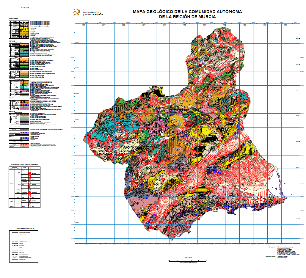
Geological Map of the Region of Murcia, scale 1:200.000
Map showing the chronolithostratigraphic units of the Region of Murcia grouped by the different structural domains present in the region, accompanied by the tectonic structure expressed by faults and traces of folding structures. On the Neogene and Quaternary units, the different facies present in each of them have been differentiated, reflecting the sedimentation domain and system, the geomorphological unit and the lithology.
Simple
- Alternate title
-
GeoMurcia 200
- Date (Creation)
- 1989-01-01
- Date (Publication)
- 2003-01-01
- Citation identifier
- IGME-CSIC / ESPIGMEGEOMURCIA200
- Citation identifier
-
25066
Identification of the Documentation Centre of Geological Survey of Spain
- Presentation form
- Digital map
- Presentation form
- Digital document
- Presentation form
- Hardcopy map
- Presentation form
- Hardcopy document
- Purpose
-
The objective is to have joint and continuous geological information of the Community of Murcia available for regional planning in aspects related to geological resources, geological risks, environmental protection and communications networks.
To highlight the geological knowledge of the Region through the synthesis of geological cartography on a larger scale.
- Credit
-
Funding and Preparing Agency: IGME
Carried out by: J. Baena Pérez (Technical direction)
IN INLAND AREAS
F. Álvarez, F. Aldaya and F. Navarro
IN THE NEOGENE BASINS
J. Rodríguez, C. Santisteban and E. Elízaga
IN GEOMORPHOLOGY AND QUATERNARY
J. L. Goy, C. Zazo, L. Somoza, T. Bardají y P. Silva
Project leader: L. Bernadeu (C.A.R.M.)
V. Gabaldón (I.G.M.E.)
- Status
- Completed
- Point of contact
-
Organisation name Individual name Electronic mail address Role Instituto Geológico y Minero de España (IGME-CSIC)
Alejandro Robador Moreno
Point of contact
- Maintenance and update frequency
- Not planned
-
IGME Thesaurus
-
-
General geology.geology
-
Structural geology.fault
-
Structural geology.folding
-
Sedimentology and sedimentary petrology.lithofacies
-
-
CEOLocation
-
-
COUNTRIES
-
SPAIN
-
- Keywords
-
-
Spain
-
- Keywords
-
-
Murcia
-
-
GEMET
-
-
MEDIO NATURAL, MEDIO ANTRÓPICO
-
LITHOSPHERE (soil, geological processes)
-
lithosphere
-
rocks
-
- Keywords
-
- Specific usage
-
Investigation of mineral deposits and industrial rocks; Investigation of hydraulic resources, especially those related to groundwater; Neotectonic, seismotectonic and fault activity mapping; Preliminary studies of geology applied to public works; Study of the location of solid waste dumps; Planning of wastewater disposal; Preparation of soil maps and location of suitable areas for the establishment of national parks and delimitations of points of geological interest.
- User contact info
-
Organisation name Individual name Electronic mail address Role Instituto Geológico y Minero de España (IGME-CSIC)
Point of contact
- Access constraints
- Other restrictions
- Other constraints
- No limitations on public access.
- Use constraints
- Other restrictions
- Other constraints
-
LICENCE OF USE: Conditions of public use and dissemination of information for the re-use of IGME data. http://www.igme.es/condiciones-de-uso.htm
- Use constraints
- Other restrictions
- Title
-
Mapa Geológico de España a escala 1:50.000, MAGNA Geological Map of Spain at a scale of 1:50.000, MAGNA
- Date (Revision)
- 1991-01-01
- Cited responsible party
-
Organisation name Individual name Electronic mail address Role Instituto Geológico y Minero de España (IGME-CSIC)
Point of contact
- Aggregate Datasetindentifier
- 20000
- Association Type
- Larger work citation
- Spatial representation type
- Vector
- Denominator
- 200000
- Language
- Spanish; Castilian
- Character set
- 8859 Part 1
- Topic category
-
- Geoscientific information
))
- Supplemental Information
-
Explanatory report in paper format.
Explanatory report in digital format.
The document "Memoria explicativa del mapa geológico de la Comunidad Autónoma de la Región de Murcia" and the map are accessible through the IGME Documentation Service.
- Unique resource identifier
- EPSG:23030
- Unique resource identifier
- EPSG:6230
- Unique resource identifier
- EPSG:4258
- Distribution format
-
Name Version Mapa digital: SHP - ArcView ShapeFile
Unknown
Mapa digital: PDF - Portable Document Format
Unknown
Mapa digital: ARCC - Coverage of Arc-Info
Unknown
Mapa digital: ARCE - ARC/INFO Export format
Unknown
Mapa en papel
Unknown
Servicio web: WMS - Web Map Service
1.3.0
Distributor
- Distributor contact
-
Organisation name Individual name Electronic mail address Role Instituto Geológico y Minero de España (IGME-CSIC)
Distributor
- Distributor format
-
Name Version Mapa digital: SHP - ArcView ShapeFile
-
Mapa digital: PDF - Portable Document Format
-
Mapa digital: ARCC - Coverage of Arc-Info
-
Mapa digital: ARCE - ARC/INFO Export format
-
Distributor
- Distributor contact
-
Organisation name Individual name Electronic mail address Role Centro de Documentación del Instituto Geológico y Minero de España (IGME-CSIC)
Distributor
- Distributor format
-
Name Version Mapa en papel
-
Distributor
- Distributor contact
-
Organisation name Individual name Electronic mail address Role Vicedirección Técnica de Sistemas de Información Geológica del Instituto Geológico y Minero del España (IGME-CSIC)
Distributor
- Distributor format
-
Name Version Servicio web: WMS - Web Map Service
1.3.1
- OnLine resource
-
Protocol Linkage Name OGC:WMS-1.3.0-http-get-capabilities
http://mapas.igme.es/gis/services/Cartografia_Geologica/IGME_GeologicoMurcia_200/MapServer/WMSServer?Request=GetCapabilities&Service=WMS Link to the GetCapabilities of the web service hosting the product
WWW:LINK-1.0-http--related
https://mapas.igme.es/Servicios/default.aspx#IGME_GeologicoMurcia_200 Link to the product page on the IGME web site
- Name
- CDROM
- Hierarchy level
- Dataset
Completeness commission
- Name of measure
-
Duplicate phenomena
- Measure description
-
Geometric and topological control using GIS application tools.
Conformance result
- Title
-
Geometric and topological control using the tools of the GIS application.
- Date (Revision)
- 2003-01-01
- Explanation
-
0% error rate
- Pass
- Yes
Completeness omission
- Name of measure
-
Lack of phenomena
- Measure description
-
Visual spot check and cross-checking of spatial information with attribute tables
Conformance result
- Title
-
Visual spot check and cross-checking of spatial information with attribute tables
- Date (Revision)
- 2003-01-01
- Explanation
-
Digital comparative validation and visual comparative check of the original map and the digitised map. Validation with error rate < 1%.
- Pass
- Yes
Conceptual consistency
- Name of measure
-
Degree of approximation of the digital data with the conceptual model. Distribution of phenomena in classes.
- Measure description
-
Verificación manual
Conformance result
- Title
-
MAGNA geological mapping data model in digital format.
- Date (Revision)
- 2012-02-01
- Explanation
-
Check that the digital information is consistent with the standards that conceptually define it. Consult the standard
- Pass
- Yes
Conceptual consistency
- Name of measure
-
Degree of approximation of the digital data with the conceptual model. Properties of the phenomena
- Measure description
-
Automatic verification
Conformance result
- Title
-
MAGNA geological mapping data model in digital format.
- Date (Revision)
- 2012-02-01
- Explanation
-
Check that the digital information is consistent with the standards that conceptually define it. Consult the standard
- Pass
- Yes
Format consistency
- Name of measure
-
Degree of approximation of the data to the established physical structure
- Measure description
-
Autonomous verification
Conformance result
- Title
-
Specifications for the digitisation of MAGNA geological mapping.
- Date (Revision)
- 2012-02-01
- Explanation
-
Check that the digital information is in accordance with the standards. Consult the standard
- Pass
- Yes
Absolute external positional accuracy
- Name of measure
-
External absolute accuracy
- Measure description
-
Mean square error in the map registration to digitise
Conformance result
- Title
-
Mean square error in the map registration to digitise
- Date (Revision)
- 2003-01-01
- Explanation
-
Verification that the positional error is less than that required by the scale of the map < 40 m
- Pass
- Yes
Thematic classification correctness
- Name of measure
-
Absence of errors in the assignment of classes to phenomena.
- Measure description
-
Comparative study with original map. Random sampling
Conformance result
- Title
-
Comparative study with original map. Random sampling
- Date (Revision)
- 2003-01-01
- Explanation
-
Digital comparative validation and visual comparative check of the original map and the digitised map. Validation with error rate < 1%.
- Pass
- Yes
Thematic classification correctness
- Name of measure
-
Comparative study with original map
- Measure description
-
Comparative study with original map
Conformance result
- Title
-
Comparative study with original map
- Date (Revision)
- 2003-01-01
- Explanation
-
Digital comparative validation and comparative visual check of the original map and the digitised map. Error rate 1%. Error area < 0.1% in cartographic units.
- Pass
- Yes
Non quantitative attribute accuracy
- Name of measure
-
Accuracy of non-quantitative attributes: absence of errors in the assignment of values.
- Measure description
-
Comparative study with original map
Conformance result
- Title
-
Comparative study with original map
- Date (Revision)
- 2003-01-01
- Explanation
-
Digital comparative validation and comparative visual check of the original map and the digitised map. Error rate 1%. Error area < 0.1% in cartographic units.
- Pass
- Yes
Conformance result
Conformance result
- Title
-
Reglamento (UE) n o 1089/2010 de la Comisión de 23 de noviembre de 2010 por el que se aplica la Directiva 2007/2/CE del Parlamento Europeo y del Consejo en lo que se refiere a la interoperabilidad de los conjuntos y los servicios de datos espaciales
- Date (Publication)
- 2010-12-08
Citation identifier
- Explanation
-
Consult the regulations
- Pass
- No
Conformance result
Conformance result
- Title
-
Reglamento (CE) n.o 1205/2008 de la Comisión de 3 de Diciembre de 2008 que estabelece las modalidades de aplicación de la Directiva 2007/2/CE del Parlamento Europeo y del Consejo em materia de metadados
- Date (Publication)
- 2008-12-04
- Explanation
-
Consult the regulations
- Pass
- Yes
- Statement
-
Map elaborated from the National Geological Map at scale 1:50.000 (second series), MAGNA with the incorporation of data from several doctoral theses elaborated between 1973 and 1990. Occasionally, field work has been carried out to solve several existing problems related to the correlation between units. Digitisation carried out in 2003. Normalisation and generation of symbolised files (.lyr) and cartography, in version 8.2 of ArcGIS, in 2003.
- Description
-
Compilation and analysis of previous information:
Compilation of MAGNA geological information and of work carried out in the area covered by the sheet carried out subsequent to the MAGNA sheets.
- Description
-
Production of the map:
Study of the cartographic units and revision of the samples.
Preparation of the legend Correlation between the cartographic units of the MAGNA sheets and the chronolithostratigraphic legend of the 1:100,000 scale map.
Spatial adjustment between sheet boundaries.
Adjustment to the selected topographic base.
Drawing of the geological map at a scale of 1:100.000.
- Description
-
Process of digitisation of the information:
Inventory, selection and codification of the phenomena that will comprise the digital cartography.
Digitisation in accordance with the Institute's specifications.
Geometric processing.
Association of attributes to spatial objects and creation of tables.
Checking of digital information, detection and correction of errors.
- Description
-
The rock units of the sheet separated by different types of contacts are represented, together with the tectonic structure, faults and map traces of folds, the orientation and dip of planar and linear elements contained in the rocks, structural and textural singularities of igneous and metamorphic rocks, water points, mineral deposits and indications, presence of fossils and other elements of punctual representation.
- Denominator
- 50000
- Title
-
Geological Map of Spain scale 1:50.000 MAGNA (Second series 1st edition)
- Date (Creation)
- 1971-01-01
- Cited responsible party
-
Organisation name Individual name Electronic mail address Role Instituto Geológico y Minero de España (IGME-CSIC)
Martín-Serrano García, Ángel
Originator Instituto Geológico y Minero de España (IGME-CSIC)
Robador Moreno, Alejandrol
Distributor
- Presentation form
- Digital document
- Presentation form
- Digital map
- Presentation form
- Hardcopy document
- Presentation form
- Hardcopy map
Metadata
- File identifier
- ESPIGMEGEOMURCIA2002010112425066 XML
- Metadata language
- Spanish; Castilian
- Character set
- UTF8
- Hierarchy level
- Dataset
- Date stamp
- 2026-05-18T15:15:57.028903Z
- Metadata standard name
-
ISO 19115 "Perfil IGME"
- Metadata standard version
-
2003 "1.0"
- Metadata author
-
Organisation name Individual name Electronic mail address Role Instituto Geológico y Minero de España (IGME-CSIC)
Leticia Vega Martín
Point of contact
- Other language
-
Language Character encoding English UTF8 Spanish; Castilian UTF8
)))