 Catalogo de metadatos IGME-CSIC
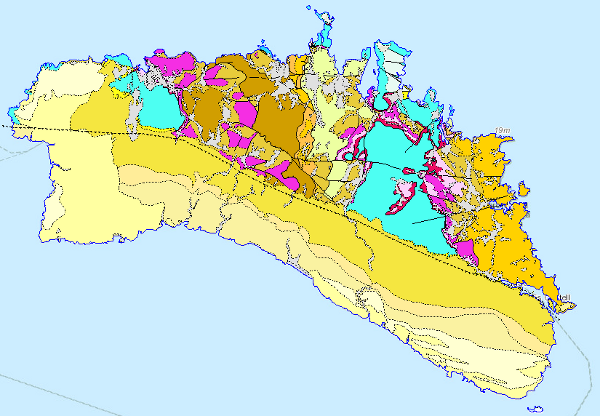
Mapa Geológico de Menorca a escala 1:100.000
This Map depicts the materials or rocks that appear on the surface of the sheet, their spatial distribution, nature and geometrical relationships. The cartographic units are chronostratigraphic groupings, with common lithology and age formed by strata which are called formations, groups or members; other non-stratified ones such as granites are represented. The structural relationships between them are expressed by symbols, which gives the map a three-dimensional character that is completed by additional geological profiles. These are the graphic expression of the deep geometrical arrangement of the units shown on the geological map. Applied information such as water points, mineral deposits and indications, presence of fossils and other elements of punctual representation are added by means of symbology.
The digital information, geological map 1:100.000, chronolithostratigraphic legend and legend of geological symbols, is stored in coverage format (ESRI). There is a guide that reflects its organisation and codification.
The creation of this cartography is based on the compilation of existing information, mainly MAGA cartography at a scale of 1:50,000, doctoral theses and other research work.
Simple
- Alternate title
-
GeoMenorca 100
- Date (Creation)
- 1997-01-01
- Date (Publication)
- 2009-01-01
- Citation identifier
- http://www.igme.es / 90100
- Presentation form
- Digital map
- Purpose
-
The objective is to provide geological information on the island of Menorca in a joint and continuous way for regional planning in aspects related to geological resources, geological risks, environmental protection and communication networks.
To highlight the geological knowledge of the island of Menorca from the synthesis of geological cartography on a larger scale.
- Credit
-
Organismo que financia y elabora: IGME
NORMAS, DIRECCION Y SUPERVISION DEL I.G.M.E.
Autores :
Alberto Díaz de Neira (INYPSA)
Alfredo García de Domingo (INYPSA)
I. Gil Gil (INYPSA)
Pilar Cabra Gil (INYPSA)
Dirección y supervisión del I.G.M.E : Pedro Ruíz Reig
- Status
- Completed
- Point of contact
-
Organisation name Individual name Electronic mail address Role Instituto Geológico y Minero de España (IGME-CSIC)
Díaz de Neira, Alberto
Author
- Maintenance and update frequency
- Not planned
-
IGME Thesaurus
-
-
General geology
-
General geology.geology
-
General geology.lithology
-
Structural geology.fault
-
General geology.rock
-
Stratigraphy
-
Chronostratigraphy
-
RocK
-
Sedimentary rock
-
Crystalline rock
-
Igneous rock
-
Quaternary Geomorphology and Geology
-
Surface formation
-
Structural geology
-
Folding
-
Stratigraphy Systematics
-
Mesozoic
-
Triassic
-
Jurassic
-
Cretaceous
-
Neogene
-
Quaternary
-
-
GEMET
-
-
NATURAL ENVIRONMENT, ANTHROPOGENIC ENVIRONMENT
-
LITHOSPHERE (soil, geological processes)
-
lithosphere
-
rocks
-
- Specific usage
-
The Geological Map of Menorca at a scale of 1:100,000 can be used for all activities related to hydrogeological and mineral resources, public works, agriculture, land use, territorial planning, the environment, forecasting, prevention and mitigation of geological risks and in general with any action on the physical environment that supports decision-making in actions on the territory is a user of this cartography.
- User contact info
-
Organisation name Individual name Electronic mail address Role Instituto Geológico y Minero de España (IGME-CSIC)
Point of contact
- Access constraints
- Other restrictions
- Other constraints
- Sin limitaciones al acceso público. No limitations on public access.
- Use constraints
- Other restrictions
- Other constraints
-
LICENCIA DE USO: Condiciones de uso público y difusión de la información para la reutilización de los datos IGME http://www.igme.es/Ayuda/CondiUso.htm LICENCE OF USE: Conditions of public use and dissemination of information for the re-use of IGME data.http://www.igme.es/Ayuda/CondiUso.htm
- Title
-
Mapa Geológico de España a escala 1:50.000, MAGNA. Geological Map of Spain at a scale of 1:50.000, MAGNA
- Date (Revision)
- 1991-01-01
- Cited responsible party
-
Organisation name Individual name Electronic mail address Role Instituto Geológico y Minero de España (IGME-CSIC)
Point of contact
- Aggregate Datasetindentifier
- 20000
- Association Type
- Larger work citation
- Spatial representation type
- Vector
- Denominator
- 100000
- Language
- Spanish; Castilian
- Character set
- 8859 Part 1
))
- Unique resource identifier
- EPSG:6230
- Unique resource identifier
- EPSG:23031
- Unique resource identifier
- EPSG:4258
- Distribution format
-
Name Version Mapa digital: SHP - ArcView ShapeFile
Unknown
Mapa digital: ARCC - Coverage of Arc-Info
Unknown
Mapa digital: ARCE - ARC/INFO Export format
Unknown
Mapa digital: PDF - Portable Document Format
Unknown
Mapa en papel
Unknown
Servicio web: WMS - Web Map Service
1.3.0
Distributor
- Distributor contact
-
Organisation name Individual name Electronic mail address Role Instituto Geológico y Minero de España (IGME-CSIC)
Distributor
- Distributor format
-
Name Version Mapa digital: SHP - ArcView ShapeFile
-
Mapa digital: ARCC - Coverage of Arc-Info
-
Mapa digital: ARCE - ARC/INFO Export format
-
Mapa digital: PDF - Portable Document Format
-
Distributor
- Distributor contact
-
Organisation name Individual name Electronic mail address Role Centro de Documentación del Instituto Geológico y Minero de España (IGME-CSIC)
Distributor
- Distributor format
-
Name Version Mapa en papel
-
Distributor
- Distributor contact
-
Organisation name Individual name Electronic mail address Role Vicedirección Técnica de Sistemas de Información Geológica del Instituto Geológico y Minero del España (IGME-CSIC)
Distributor
- Distributor format
-
Name Version Servicio web: WMS - Web Map Service
1.3.0
- OnLine resource
-
Protocol Linkage Name OGC:WMS-1.3.0-http-get-capabilities
http://mapas.igme.es/gis/services/Cartografia_Geologica/IGME_GeologicoMenorca_100/MapServer/WMSServer?Request=GetCapabilities&Service=WMS Link to the GetCapabilities of the web service hosting the product
WWW:LINK-1.0-http--related
http://mapas.igme.es/Servicios/default.aspx#IGME_GeologicoMenorca_100 Link to the product page on the IGME web site
- Hierarchy level
- Dataset
Completeness commission
- Name of measure
-
Duplicate phenomena.
- Measure description
-
Geometric and topological control using the tools of the GIS application.
Conformance result
- Title
-
Geometric and topological control using the tools of the GIS application.
- Date (Revision)
- 2009-01-01
- Explanation
-
Error rate 0 %
- Pass
- Yes
Completeness omission
- Name of measure
-
Lack of phenomena
- Measure description
-
Visual spot check and cross-checking of spatial information with attribute tables.
Conformance result
- Title
-
Visual spot check and cross-checking of spatial information with attribute tables.
- Date (Revision)
- 2009-01-01
- Explanation
-
Digital comparative validation and visual comparative check of the original map and the digitised map. Validation with error rate < 1%.
- Pass
- Yes
Conceptual consistency
- Name of measure
-
Degree of approximation of the digital data with the conceptual model. Distribution of phenomena in classes.
- Measure description
-
Manual verification.
Conformance result
- Title
-
MAGNA geological mapping data model in digital format.
- Date (Revision)
- 2012-02-01
- Explanation
-
Check that the digital information is consistent with the standards that conceptually define it. Consult the standard
- Pass
- Yes
Conceptual consistency
- Name of measure
-
Degree of approximation of the digital data with the conceptual model. Properties of the phenomena
- Measure description
-
Automatic verification.
Conformance result
- Title
-
MAGNA geological mapping data model in digital format.
- Date (Publication)
- 2012-02-01
- Explanation
-
Check that the digital information is consistent with the standards that conceptually define it. Consult the standard
- Pass
- Yes
Conceptual consistency
- Name of measure
-
Existence of codes outside the established range for each attribute.
- Measure description
-
Automatic verification.
Conformance result
- Title
-
MAGNA geological mapping data model in digital format.
- Date (Revision)
- 2012-02-01
- Explanation
-
Check that the digital information is consistent with the standards that conceptually define it. Consult the standard
- Pass
- Yes
Format consistency
- Name of measure
-
Degree of approximation of the data to the established physical structure.
- Measure description
-
Automatic verification
Conformance result
- Title
-
Specifications for the digitisation of MAGNA geological mapping.
- Date (Revision)
- 2012-02-01
- Explanation
-
Check that the digital information is in accordance with the standards. Consult the standard
- Pass
- Yes
Format consistency
- Name of measure
-
Degree of conformity of the data to the defined topological rules. Absence of geological contacts with any of their ends (nodes) not connected to another node of another contact, a fault or a conventional boundary.
- Measure description
-
Automatic verification
Conformance result
- Title
-
Data model of the MAGNA geological mapping in digital form
- Date (Revision)
- 2012-02-01
- Explanation
-
Check that the digital information is in accordance with the standards. Consult the standard
- Pass
- Yes
Format consistency
- Name of measure
-
Degree of conformity of the data to the defined topological rules. Absence of geological contacts separating enclosures belonging to the same cartographic unit.
- Measure description
-
Automatic verification
Conformance result
- Title
-
Data model of the MAGNA geological mapping in digital form
- Date (Revision)
- 2012-02-01
- Explanation
-
Check that the digital information is in accordance with the standards. Consult the standard
- Pass
- Yes
Absolute external positional accuracy
- Name of measure
-
External absolute accuracy
- Measure description
-
Mean square error in the registration of the map to be digitised.
Conformance result
- Title
-
Mean square error in the registration of the map to be digitised.
- Date (Revision)
- 2009-01-01
- Explanation
-
Verification that the positional error is less than that required by the scale of the map > 20
- Pass
- Yes
Thematic classification correctness
- Name of measure
-
Absence of errors in the assignment of classes to phenomena.
- Measure description
-
Comparative study with the original mapping. Random sampling
Conformance result
- Title
-
Comparative study with the original mapping. Random sampling
- Date (Revision)
- 2009-01-01
- Explanation
-
Digital comparative validation and visual comparative check of the original map and the digitised map. Validation with error rate < 1%.
- Pass
- Yes
Thematic classification correctness
- Name of measure
-
Absence of errors in the assignment of identifiers to cartographic units.
- Measure description
-
Comparative study with original map
Conformance result
- Title
-
Comparative study with original map
- Date (Revision)
- 2009-01-01
- Explanation
-
Digital comparative validation and comparative visual check of the original map and the digitised map. Error rate 1%. Error area < 0.1% in cartographic units.
- Pass
- Yes
Non quantitative attribute accuracy
- Name of measure
-
Absence of errors in the assignment of values.
- Measure description
-
Comparative study with original map
Conformance result
- Title
-
Comparative study with original map
- Date (Revision)
- 2009-01-01
- Explanation
-
Digital comparative validation and comparative visual check of the original map and the digitised map. Error rate 1%. Error area < 0.1% in cartographic units.
- Pass
- Yes
Conformance result
- Date (Publication)
- 2010-12-08
- Explanation
-
Consult the above-mentioned regulation
- Pass
- No
- Statement
-
Map made from the MAGNA geological cartography (scale 1:25.000) of the island. Study of the units of the sheets and creation of the chronolithostratigraphic legend significant for the scale. Adjustment and matching of sheets with the aggregation and generalisation of the MAGNA sheet units for the creation of the 1:100,000 scale map. Drawing of the map adjusted to the topographic base.
Digitisation carried out in 2001. Normalisation and generation of symbolised files (.lyr) and cartography, in version 8.2 of ArcGIS, in 2003.
- Description
-
Compilation and analysis of previous information:
Compilation of MAGNA geological information and of work carried out in the area covered by the sheet carried out subsequent to the MAGNA sheets.
- Description
-
Production of the map:
Study of the cartographic units and revision of the samples.
Preparation of the legend Correlation between the cartographic units of the MAGNA sheets and the chronolithostratigraphic legend of the 1:100,000 scale map.
Spatial adjustment between sheet boundaries.
Adjustment to the selected topographic base.
Drawing of the geological map at 1:100.000 scale.
- Description
-
Process of digitalisation of the information:
Analysis of the entities present in the cartography. Assignment of codes.
Digitisation of geological contacts and faults. Generation of the enclosures that constitute the cartographic units. Digitisation of the rest of the geological entities. Digitisation of the chronolithostratigraphic legend.
Error control and correction.
- Description
-
The rock units of the sheet separated by different types of contacts are represented, together with the tectonic structure, faults and map traces of folds, the orientation and dip of planar and linear elements contained in the rocks, structural and textural singularities of igneous and metamorphic rocks, water points, mineral deposits and indications, presence of fossils and other elements of punctual representation.
- Denominator
- 50000
- Title
-
Geological Map of Spain at scale 1:50.000 MAGNA (IGME)
- Date (Creation)
- 1971-01-01
- Cited responsible party
-
Organisation name Individual name Electronic mail address Role Instituto Geológico y Minero de España (IGME-CSIC)
Martín-Serrano García, Ángel
Originator Instituto Geológico y Minero de España (IGME-CSIC)
Robador Moreno, Alejandro
Distributor
- Presentation form
- Hardcopy map
- Presentation form
- Hardcopy document
Metadata
- File identifier
- ESPIGMEGEOMENORCA1002010111990100 XML
- Metadata language
- Spanish; Castilian
- Character set
- UTF8
- Hierarchy level
- Dataset
- Date stamp
- 2025-05-12T11:21:58.054947Z
- Metadata standard name
-
Reglamento (CE) Nº 1205/2008 de Inspire, "Perfil IGME"
- Metadata standard version
-
TG 2.0
- Metadata author
-
Organisation name Individual name Electronic mail address Role Instituto Geológico y Minero de España (IGME-CSIC)
Leticia Vega Martín
Point of contact
- Other language
-
Language Character encoding English UTF8 Spanish; Castilian UTF8
)))