 Catalogo de metadatos IGME-CSIC
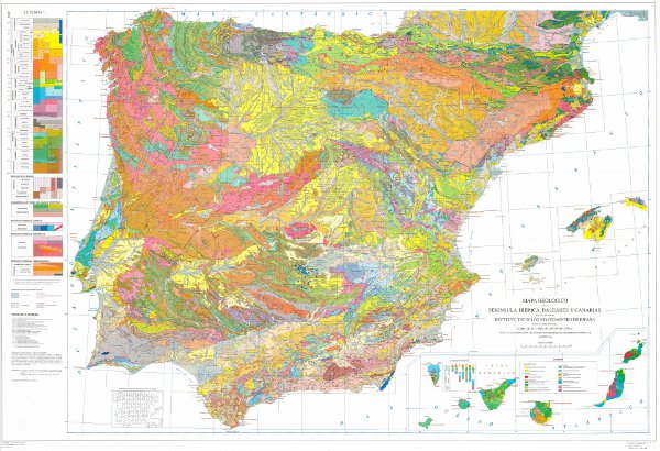
Mapa Geológico de la Península Ibérica, Baleares y Canarias a escala 1:1.000.000, edición 1995
Geological Map of the Iberian Peninsula, Balearic and Canary islands, at scale 1:1,000,000, 1995 edition.
El Mapa Geológico de la península ibérica, Baleares y Canarias o Mapa Geológico de España a escala 1:1.000.000 es un mapa desarrollado por el Instituto Geológico y Minero de España (IGME-CSIC) de forma cíclica desde su fundación, siendo la versión de 1995 la primera en digitalizarse. Este mapa es una infraestructura de conocimiento geológico homogéneo y global a una unidad geológica de escala continental como es la Península Ibérica. El Mapa contiene las unidades cronolitoestratigráficas con representación de la estructura tectónica mediante fallas y cabalgamientos. Además está acompañado por dos leyendas cronolitoestratigráficas (Península y Baleares e Islas Canarias) y los signos convencionales. Cada una de las unidades geológicas tiene asociada su descripción, los tipos de rocas dominantes y la edad cronoestratigráfica con precisión hasta el Piso, cuando está disponible. No existe diferencia entre los contactos de las unidades cartográficas, considerándose todos ellos como contactos litológicos, a excepción de aquellos que son producto de las fallas. El mapa es consistente con una base topográfica a escala 1:1.000.000 anterior a la BCN 1000 del IGN que sólo se encuentra disponible en formato papel.La información geológica de la Península Ibérica e Islas Baleares se encuentra en proyección UTM, huso 30, datum Postdam. La información de las Islas Canarias se encuentra en proyección UTM, huso 28, datum Pico de las Nieves. El mapa se distribuye gratuitamente en formato shape a través de la página Web del IGME.
The Geological Map of the iberian peninsula, Balearic and Canary Islands or Geological Map of Spain at a scale of 1:1,000,000 is a map developed by the Geological Survey of Spain (IGME-CSIC) on a cyclical basis since its foundation, being the 1995 version the first to be digitised. This map is an infrastructure of homogeneous and global geological knowledge of a geological unit of continental scale such as the Iberian Peninsula. The map contains the chronolithostratigraphic units with representation of the tectonic structure by means of faults and thrusts. It is also accompanied by two chronolithostratigraphic legends (Peninsula and Balearic and Canary Islands) and the conventional signs. Each of the geological units has an associated description, the dominant rock types and the chronostratigraphic age with precision down to the Flo, when available. There is no difference between the contacts of the map units, all of them being considered as lithological contacts, with the exception of those that are the product of faults. The map is consistent with a topographic base at a scale of 1:1,000,000 prior to the BCN 1000 of the IGN, which is only available in paper format. The geological information on the Iberian Peninsula and the Balearic Islands is in UTM projection, zone 30, Postdam datum. The information on the Canary Islands is in UTM projection, zone 28, datum Pico de las Nieves. The map is distributed free of charge in shape format through the IGME website.
Simple
-
Título alternativoAlternate title
-
Geologico1000_Edicion1995
Geologico1000_Edicion1995
-
Date (Creation)Fecha (Creación)
- 1994-01-01
-
Date (Publication)Fecha (Publicación)
- 1995-01-01
- Edition
-
1ª Edición
-
Edition dateFecha de edición
- 1995-01-01
-
Citation identifierIdentificador del Contacto
-
26047
Identificación del Instituto Geológico y Minero de España. Centro de DocumentaciónIdentification of Geological Survey of Spain. Documentation Center1979-01-01
-
Citation identifierIdentificador del Contacto
- IGME-CSIC / ESPIGMEGEOLOGICO1000EDICION1995
-
Presentation formFormulario de presentación
-
Hardcopy mapMapa en papel
-
Presentation formFormulario de presentación
-
Digital mapMapa digital
-
PropósitoPurpose
-
El Mapa Geológico de la Península Ibérica, Baleares y Canarias sintetiza el conocimiento geológico alcanzado hasta la fecha de elaboración. Es un mapa con orientación divulgativa y educativa.
The Geological Map of the Iberian Peninsula, Balearic and Canary Islands synthesises the geological knowledge achieved up to the date of preparation. It is a map with an informative and educational orientation.
-
CréditoCredit
-
La síntesis geológica ha sido realizada por: Alvaro, M.; Apalategui, O.; Baena, J.; Balcells, R.; Barnolas, A.; Barrera, J.L.; Bellido, F.; Cueto, L.A.; Díaz de Neira, A.; Elízaga, E.; Fernández-Gianotti, J.; Ferreiro, E.; Gabaldón, V.; García-Sansegundo, J.; Gómez, J.A.; Heredia, N.; Hernández-Urroz, J.; Hernández-Samaniego,J.; Lendínez, A.; Leyva, F.; López-Olmedo, F.; Lorenzo, S.; Martín, L.; Martín, D.; Martín-Serrano, A.; Matas, J.; Monteserín, V.; Nozal, F.; Olivé, A.; Ortega, E.; Piles, E.; Ramírez, J.I.; Robador, A.; Roldán, F; Rodríguez, L.R.; Ruízz, P.; Ruíz, M.T:; Sánchez-Carretero, R. y Teixel, A. Para la realización de este producto se ha contado con la colaboración del Instituto Geológico y Mineiro de Portugal. Coordinadores: Oliveira, J.T.; Pereira, E.; Ranalho, M y País, J.
The geological synthesis has been carried out by: Alvaro, M.; Apalategui, O.; Baena, J.; Balcells, R.; Barnolas, A.; Barrera, J.L.; Bellido, F.; Cueto, L.A.; Díaz de Neira, A.; Elízaga, E.; Fernández-Gianotti, J.; Ferreiro, E. ; Gabaldón, V.; García-Sansegundo, J.; Gómez, J.A.; Heredia, N.; Hernández-Urroz, J.; Hernández-Samaniego,J.; Lendínez, A.; Leyva, F.; López-Olmedo, F.; Lorenzo, S. ; Martín, L.; Martín, D.; Martín-Serrano, A.; Matas, J.; Monteserín, V.; Nozal, F.; Olivé, A.; Ortega, E.; Piles, E.; Ramírez, J.I.; Robador, A.; Roldán, F.; Rodríguez, L.R. Ruízz, P.; Ruíz, M.T.; Sánchez-Carretero, R. and Teixel, A. This product has been produced with the collaboration of the Instituto Geológico y Mineiro de Portugal. Coordinators: Oliveira, J.T.; Pereira, E.; Ranalho, M. and País
-
StatusEstado
-
CompletedTerminado
- Point of contact
-
Organisation name Individual name Electronic mail address Role Instituto Geológico y Minero de España (IGME-CSIC)Geological Survey of Spain (IGME-CSIC)Alejandro Robador Moreno
Point of contactPunto de Contacto
-
Maintenance and update frequencyMantenimiento y frecuencia de actualización
-
Not plannedSin planificar
-
Tesauro IGME
IGME Thesaurus
-
-
Geología general.geología
Geología general.geología
-
Estratigrafía.litoestratigrafía
Stratigraphy.lithostratigraphy
-
Estratigrafía.cronoestratigrafía
Stratigraphy.Chronostratigraphy
-
Geología general.litología
General geology.lithology
-
Sistemática de rocas metamórficas.roca metamórfica
Systematics of metamorphic rocks.metamorphic rock
-
Geología general.roca.roca cristalina.roca ígnea
General geology.rock.crystalline rock.igneous rock)
-
Geología general.tectonita
General geology.tectonite
-
Geología estructural.falla
Structural geology.fault
-
Sistemática de Geografía.España
Systematics of Geography.Spain
-
Geología general.roca.roca sedimentaria
General geology.rock.sedimentary rock
-
Geología general.contacto
General geology.contact
-
Sistemática de Estratigrafía.PrecÁmbrico
Systematics of Stratigraphy.Precambrian
-
Sistemática de Estratigrafía.Paleozoico
Systematics of stratigraphy.Palaeozoic
-
Sistemática de Estratigrafía.Mesozoico
Systematics of Stratigraphy.Mesozoic
-
Sistemática de Estratigrafía.Cenozoico
Systematics of stratigraphy.Cenozoic
-
Sistemática de Estratigrafía.Cuaternario
Systematic Stratigraphy.Quaternary
-
-
GEMET
GEMET
-
-
MEDIO NATURAL, MEDIO ANTRÓPICO
NATURAL ENVIRONMENT, ANTHROPIC ENVIRONMENT
-
LITOSFERA (suelo, procesos geológicos)
LITHOSPHERE (soil, geological processes)
-
litosfera
lithosphere
-
rocas
rocKs
-
- Keywords
-
-
EGDI
EGDI
-
InventoryGM
-
HVD
-
-
Uso específicoSpecific usage
-
El Mapa Geológico de España a escala 1:1.000.000 se utiliza con fines divulgativos y educativos. También se puede emplear como referencia nacional para cartografía derivada a la misma escala como hidrogeológica; de riesgos geológicos o de recursos minerales.
The Geological Map of Spain at a scale of 1:1,000,000 is used for informative and educational purposes. It can also be used as a national reference for derived cartography at the same scale such as hydrogeology, geological risks or mineral resources.
- User contact info
-
Organisation name Individual name Electronic mail address Role Instituto Geológico y Minero de España (IGME-CSIC)Geological Survey of Spain (IGME-CSIC)Point of contactPunto de Contacto
-
Access constraintsRestricciones de Acceso
-
Other restrictionsOtras restricciones
-
Otras limitacionesOther constraints
-
Sin limitaciones al acceso públicoNo limitations on public access
-
Use constraintsRestricciones de uso
-
Other restrictionsOtras restricciones
-
Otras limitaciones
-
CC BY 4.0
-
Otras limitaciones
-
Nombrar a la fuente: Instituto Geológico y Minero de España (IGME-CSIC)
-
TítuloTitle
-
Mapa Geológico de España a escala 1:50.000 (MAGNA). Segunda serie. Primera edición.
Geological Map of Spain at a scale of 1:50.000 (MAGNA). Second series. First edition
-
Date (Revision)Fecha (Revisión)
- 1991-01-01
- Cited responsible party
-
Organisation name Individual name Electronic mail address Role Instituto Geológico y Minero de España (IGME-CSIC)Geological Survey of Spain (IGME-CSIC)Point of contactPunto de Contacto
-
Aggregate DatasetindentifierIdentificador del Conjunto de Datos Agregado
- 20000
-
Association TypeTipo de asociación
-
Cross referenceReferencia cruzada
-
TítuloTitle
-
Mapa Geológico de España a escala 1:200.000
Geological Map of Spain at scale 1:200.000
-
Date (Publication)Fecha (Publicación)
- 1983-01-01
- Cited responsible party
-
Organisation name Individual name Electronic mail address Role Instituto Geológico y Minero de España (IGME-CSIC)Geological Survey of Spain (IGME-CSIC)Point of contactPunto de Contacto
-
Aggregate DatasetindentifierIdentificador del Conjunto de Datos Agregado
- 22100
-
Association TypeTipo de asociación
-
Cross referenceReferencia cruzada
-
Spatial representation typeTipo de representación espacial
-
VectorVector
-
DenominatorDenominador
- 200000
-
LanguageIdioma
- Spanish; Castilian
-
Character setCodificación
-
UTF8UTF8
-
DescripciónDescription
-
España
Spain
))
-
Información SuplementariaSupplemental Information
-
La versión en papel se encuentra agotada. No existe memoria asociada al mapa.
The paper version is out of print. There is no memory associated with the map.
-
Identificador único del recursoUnique resource identifier
-
EPSG:4258 (ETRS89 coordenadas geográficas)EPSG:4258 (ETRS89 coordenadas geográficas)
-
Identificador único del recursoUnique resource identifier
-
EPSG:23030 (ED50 / UTM zone 30N)EPSG:23030 (ED50 / UTM zone 30N)
-
Identificador único del recursoUnique resource identifier
-
EPSG:23028 (ED50 / UTM zone 28N Pico de las Nieves)EPSG:23028 (ED50 / UTM zone 28N Pico de las Nieves)
- Distribution format
-
Name Version Mapa digital: SHP - ArcView ShapeFile
8.2
Mapa digital: ARCE - ARC/INFO Export format
Unknown
Mapa digital: ARCC - Coverage of Arc-Info
ArcInfo 9.1
Servicio web: WMS - Web Map Service
1.3.0
GeoPackage
1.3
Distributor
Distribuidor
- Distributor contact
-
Organisation name Individual name Electronic mail address Role Instituto Geológico y Minero de España (IGME-CSIC)Geological Survey of Spain (IGME-CSIC)DistributorDistribuidor
- Fees
-
Distribución a través de la web gratuita
- Distributor format
-
Name Version Mapa digital: SHP - ArcView ShapeFile
Mapa digital: SHP - ArcView ShapeFile
8.2
Mapa digital: ARCE - ARC/INFO Export format
Mapa digital: ARCE - ARC/INFO Export format
-
Mapa digital: ARCC - Coverage of Arc-Info
Mapa digital: ARCC - Coverage of Arc-Info
ArcInfo 9.1
Mapa digital: PDF - Portable Document Format
Mapa digital: PDF - Portable Document Format
-
Mapa digital: JPEG -Joint Photographic Group Format
Mapa digital: JPEG -Joint Photographic Group Format
-
Distributor
Distribuidor
- Distributor contact
-
Organisation name Individual name Electronic mail address Role Área de Sistemas de Información Geológica del Instituto Geológico y Minero del España (IGME-CSIC)
Geological Information Systems Area of the Geological Survey of Spain (IGME-CSIC)
DistributorDistribuidor
- Distributor format
-
Name Version Servicio web: WMS - Web Map Service
Servicio web: WMS - Web Map Service
1.3.0
- Units of distribution
-
El mapa Geológico de España está compuesto por un único bloque formado por: 2 coberturas con la información geológica (Península e islas Baleares, islas Canarias), 2 coberturas con las leyendas (Península e islas Baleares, islas Canarias) y 4 tablas asociadas con edades, litologías, litofacies y simbología.
- OnLine resource
-
NameNombre
-
CDROMCDROM
-
Hierarchy levelJerarquía
-
DatasetConjunto de datos
Completeness commission
Comisión de Completitud
-
Nombre de la medidaName of measure
-
Fenómenos inexistentes en la cartografía original pero que si que existen en el producto digital.
Phenomena that do not exist in the original cartography but do exist in the digital product.
-
Descripción de la medidaMeasure description
-
Chequeo visual aleatorio y cruce de información espacial con las tablas de atributos.
Visual spot check and cross-checking of spatial information with attribute tables.
Conformance result
Conformidad del Resultado
-
TítuloTitle
-
Chequeo visual aleatorio y cruce de información espacial con las tablas de atributos
Visual spot check and cross-checking of spatial information with attribute tables
-
Date (Revision)Fecha (Revisión)
- 1995-01-01
-
ExplicaciónExplanation
-
Validación comparativa digital y chequeo visual comparativo del mapa original y el mapa digitalizado. Validación con tasa de error & 1%
Digital comparative validation and visual comparative check of the original map and the digitised map. Validation with error rate & 1%.
-
PassAprobado
- Yes
Completeness commission
Comisión de Completitud
-
Nombre de la medidaName of measure
-
Fenómenos duplicados
Duplicate phenomena
-
Descripción de la medidaMeasure description
-
Control geométrico y topológico mediante las herramientas de la aplicación SIG.
Geometric and topological control using the tools of the GIS application.
Conformance result
Conformidad del Resultado
-
TítuloTitle
-
Control geométrico y topológico mediante las herramientas de la aplicación SIG
Geometric and topological control using the tools of the GIS application.
-
Date (Revision)Fecha (Revisión)
- 1995-01-01
-
ExplicaciónExplanation
-
Tasa de error 0%
0% error rate
-
PassAprobado
- Yes
Completeness omission
Omisión de completitud
-
Nombre de la medidaName of measure
-
Falta de fenómenos
Lack of phenomena
-
Descripción de la medidaMeasure description
-
Chequeo visual aleatorio y cruce de información espacial con las tablas de atributos.
Visual spot check and cross-checking of spatial information with attribute tables.
Conformance result
Conformidad del Resultado
-
TítuloTitle
-
Chequeo visual aleatorio y cruce de información espacial con las tablas de atributos
Visual spot check and cross-checking of spatial information with attribute tables
-
Date (Publication)Fecha (Publicación)
- 1995-01-01
-
ExplicaciónExplanation
-
Validación comparativa digital y chequeo visual comparativo del mapa original y el mapa digitalizado. Validación con tasa de error & 1%
Digital comparative validation and visual comparative check of the original map and the digitised map. Validation with error rate & 1%.
-
PassAprobado
- Yes
Conceptual consistency
Consistencia conceptual
-
Nombre de la medidaName of measure
-
Grado de aproximación de los datos digitales con el modelo conceptual. Distribución de fenómenos en clases.
Degree of approximation of the digital data with the conceptual model. Distribution of phenomena in classes.
-
Descripción de la medidaMeasure description
-
Verificación manual.
Manual verification
Conformance result
Conformidad del Resultado
-
TítuloTitle
-
Modelo de datos de la cartografía geológica MAGNA en formato digital.
MAGNA geological mapping data model in digital format.
-
Date (Revision)Fecha (Revisión)
- 2012-02-01
-
ExplicaciónExplanation
-
Comprobación de que la información digital concuerda con las normas que lo definen conceptualmente. Consultar la norma
Check that the digital information is consistent with the standards that conceptually define it. Consult the standard
-
PassAprobado
- Yes
Conceptual consistency
Consistencia conceptual
-
Nombre de la medidaName of measure
-
Grado de aproximación de los datos digitales con el modelo conceptual. Propiedades de los fenómenos
Degree of approximation of the digital data with the conceptual model. Properties of the phenomena
-
Descripción de la medidaMeasure description
-
Verificación automática.
Automatic verification
Conformance result
Conformidad del Resultado
-
TítuloTitle
-
Modelo de datos de la cartografía geológica MAGNA en formato digital.
Data model of the MAGNA geological mapping in digital form
-
Date (Revision)Fecha (Revisión)
- 2012-02-01
-
ExplicaciónExplanation
-
Comprobación de que la información digital concuerda con las normas que lo definen conceptualmente. Consultar la norma
Check that the digital information is consistent with the standards that conceptually define it. Consult the standard
-
PassAprobado
- Yes
Conceptual consistency
Consistencia conceptual
-
Nombre de la medidaName of measure
-
Grado de aproximación de los datos digitales con el modelo conceptual. Relaciones entre fenómenos.
Degree of approximation of the digital data with the conceptual model. Relationships between phenomena.
-
Descripción de la medidaMeasure description
-
Verificación automática.
Automatic verification.
Conformance result
Conformidad del Resultado
-
TítuloTitle
-
Modelo de datos de la cartografía geológica MAGNA en formato digital.
MAGNA geological mapping data model in digital format.
-
Date (Revision)Fecha (Revisión)
- 2012-02-01
-
ExplicaciónExplanation
-
Comprobación de que la información digital concuerda con las normas que lo definen conceptualmente. Consultar la norma
Check that the digital information is consistent with the standards that conceptually define it. Consult the standard
-
PassAprobado
- Yes
Quantitative attribute accuracy
Precisión de atributo cuantitativo
-
Nombre de la medidaName of measure
-
Exactitud de atributos cuantitativos: ausencia de errores en la asignación de valores
Accuracy of quantitative attributes: absence of errors in assigning values
-
Descripción de la medidaMeasure description
-
Estudio comparativo con mapa original
Comparative study with original map
Conformance result
Conformidad del Resultado
-
TítuloTitle
-
Estudio comparativo con mapa original
Comparative study with original map
-
Date (Revision)Fecha (Revisión)
- 1995-01-01
-
ExplicaciónExplanation
-
Chequeo digital de la información digital. Tasa de error 1%. Superficie de error & 0,1% en las unidades cartográficas
Digital check of digital information. Error rate 1%. Error area & 0.1% in cartographic units
-
PassAprobado
- Yes
Conformance result
Conformidad del Resultado
-
Date (Publication)Fecha (Publicación)
- 2014-12-31
-
ExplicaciónExplanation
-
Los datos no son conformesNot Conformant
-
PassAprobado
- No
Conformance result
Conformidad del Resultado
-
Date (Publication)Fecha (Publicación)
- 2008-12-24
-
ExplicaciónExplanation
-
ConformeConformant
-
PassAprobado
- Yes
-
DeclaraciónStatement
-
El mapa se ha elaborado a partir de la recopilación de la información cartográfica a escalas 1:25.000, 1:50.000, 1:200.000 y 1:1.000.000 producidas por el IGME y de otros trabajos cartográficos y documentales publicados, junto con tesis doctorales. El territorio se dividió en una serie de zonas bajo criterios geológicos. De cada zona se realizó la síntesis a escala 1:1.000.000 correspondiente. Finalmente se ajustaron y casaron las distintas zonas creando la leyenda litoestratigráfica general y ensamblándose el mapa nacional. El proceso de digitalización se realizó en el año 1996 a partir de las planchas de imprenta y la normalización definitiva y generación de ficheros simbolizados (.lyr) y cartografía, en versión 8.3 de ArcGis, en el año 2003. Se debe tener en cuenta que este mapa es consistente con una base topográfica a escala 1:1.000.000 anterior a la BCN 1000 del IGN que sólo se encuentra disponible en formato papel.
The map has been compiled from the compilation of cartographic information at scales 1:25,000, 1:50,000, 1:200,000 and 1:1,000,000 produced by the IGME and other published cartographic and documentary works, together with doctoral theses. The territory was divided into a series of zones according to geological criteria. The corresponding 1:1,000,000 scale synthesis was made for each zone. Finally, the different zones were adjusted and matched, creating the general lithostratigraphic legend and assembling the national map. The digitisation process was carried out in 1996 from the printing plates and the definitive normalisation and generation of symbolised files (.lyr) and cartography, in version 8.3 of ArcGis, in 2003. It should be noted that this map is consistent with a topographic base at a scale of 1:1,000,000 prior to the NGI's BCN 1000, which is only available in paper format.
-
DescripciónDescription
-
Recopilación de la información existente
Información bibliográfica: Base topográfica. Mapas geológicos a diversas escalas. Otros Mapas previos.
Compilation of existing information Bibliographic information: Topographic base. Geological maps at various scales. Other previous maps
-
DescripciónDescription
-
Elaboración del Mapa:División del territorio en zonas geológicas. Elaboración de la leyenda geológica de cada zona.Elaboración del mapa de cada zona.Elaboración de la leyenda general.Ajuste y casado de zonas.
Map preparation:Division of the territory into geological zones. Elaboration of the geological legend of each zone.Elaboration of the map of each zone.Elaboration of the general legend.Adjustment and matching of zones.
-
DescripciónDescription
-
Digitalización:Inventario, selección y codificación de los fenómenos que comprenderá la cartografía digital.Digitalización de acuerdo con las especificaciones del Instituto.Tratamiento geométrico.Asociación de atributos a los objetos espaciales y creación de tablas. Chequeo de la información digital, detección y corrección de errores.Verificación de la consistencia entre los diferentes mapas digitales.
Digitisation:Inventory, selection and codification of the phenomena to be included in the digital cartography.digitisation according to the Institute's specifications.geometric processing.association of attributes to the spatial objects and creation of tables.checking of digital information, detection and correction of errors.verification of consistency between the different digital maps. Checking of digital information, detection and correction of errors.verification of consistency between the different digital maps.
-
DescripciónDescription
-
Se representan las unidades rocosas de la hoja separadas por distintos tipos de contactos, junto con la estructura tectónica fallas y trazas cartográficas de los pliegues, la orientación y buzamiento de los elementos planares y lineares contenidos en las rocas, singularidades estructurales y texturales de las rocas ígneas y metamórficas, puntos de agua, yacimientos e indicios minerales, presencia de fósiles y otros elementos de representación puntual.
The rock units of the sheet separated by different types of contacts are represented, together with the tectonic structure, faults and map traces of folds, the orientation and dip of planar and linear elements contained in the rocks, structural and textural singularities of igneous and metamorphic rocks, water points, mineral deposits and indications, presence of fossils and other elements of punctual representation.
-
DenominatorDenominador
- 50000
-
TítuloTitle
-
Mapa Geológico de España escala 1:50.000 MAGNA
Geological Map of Spain scale 1:50.000 MAGNA
-
Título alternativoAlternate title
-
MAGNA
MAGNA
-
Date (Creation)Fecha (Creación)
- 1971-01-01
Citation identifier
Identificador del Contacto
- Cited responsible party
-
Organisation name Individual name Electronic mail address Role Instituto Geológico y Minero de España (IGME-CSIC)Geological Survey of Spain (IGME-CSIC)Servicio de publicaciones
Publications service
DistributorDistribuidor
-
Presentation formFormulario de presentación
-
Hardcopy documentDocumento en papel
-
Presentation formFormulario de presentación
-
Hardcopy mapMapa en papel
-
DescripciónDescription
-
Se representan las unidades rocosas de la hoja separadas por distintos tipos de contactos, junto con la estructura tectónica fallas y trazas cartográficas de los pliegues, la orientación y buzamiento de los elementos planares y lineares contenidos en las rocas, singularidades estructurales y texturales de las rocas ígneas y metamórficas, puntos de agua, yacimientos e indicios minerales, presencia de fósiles y otros elementos de representación puntual.
The rock units of the sheet separated by different types of contacts are represented, together with the tectonic structure, faults and map traces of folds, the orientation and dip of planar and linear elements contained in the rocks, structural and textural singularities of igneous and metamorphic rocks, water points, mineral deposits and indications, presence of fossils and other elements of punctual representation.
-
DenominatorDenominador
- 200000
-
TítuloTitle
-
Mapa Geológico de España escala 1:200.000
Geological Map of Spain scale 1:200,000
-
Date (Creation)Fecha (Creación)
- 1981-01-01
Citation identifier
Identificador del Contacto
- Cited responsible party
-
Organisation name Individual name Electronic mail address Role Instituto Geológico y Minero de España (IGME-CSIC)Geological Survey of Spain (IGME-CSIC)Servicio de publicaciones
Publications service
DistributorDistribuidor
-
Presentation formFormulario de presentación
-
Hardcopy mapMapa en papel
-
Presentation formFormulario de presentación
-
Hardcopy documentDocumento en papel
-
DescripciónDescription
-
El Mapa contiene las unidades cronolitoestratigráficas separadas por contactos geológicos sin diferenciar y la estructura tectónica representada mediante fallas y cabalgamientos.El Mapa contiene las unidades cronolitoestratigráficas separadas por contactos geológicos sin diferenciar y la estructura tectónica representada mediante fallas y cabalgamientos.
The Map contains the chronolithostratigraphic units separated by undifferentiated geological contacts and the tectonic structure represented by faults and thrusts.the Map contains the chronolithostratigraphic units separated by undifferentiated geological contacts and the tectonic structure represented by faults and thrusts.
-
DenominatorDenominador
- 1000000
-
TítuloTitle
-
Mapa Geológico de la Península Ibérica, Baleares y Canarias a escala 1:1.000.000, edición 1980
Geological Map of the Iberian Peninsula, Balearic and Canary Islands, scale 1:1,000,000, 1980 edition.
-
Date (Creation)Fecha (Creación)
- 1980-01-01
Citation identifier
Identificador del Contacto
- Cited responsible party
-
Organisation name Individual name Electronic mail address Role Instituto Geológico y Minero de España (IGME-CSIC)Instituto Geológico y Minero de España (IGME-CSIC)Servicio de publicaciones
Publications service
DistributorDistribuidor
-
Presentation formFormulario de presentación
-
Hardcopy mapMapa en papel
-
DescripciónDescription
-
El Mapa contiene las unidades cronolitoestratigráficas separadas por contactos geológicos sin diferenciar y la estructura tectónica representada mediante fallas y cabalgamientos.
The Map contains the chronolithostratigraphic units separated by undifferentiated geological contacts and the tectonic structure represented by faults and thrusts.
-
DenominatorDenominador
- 500000
-
TítuloTitle
-
Carta Geológica de Portugal a escala 1:500.000
Geological map of Portugal, scale 1:500 000
-
Date (Publication)Fecha (Publicación)
- 1992-01-01
Citation identifier
Identificador del Contacto
- Cited responsible party
-
Organisation name Individual name Electronic mail address Role Laboratório Nacional de Energia e Geologia (LNEG)Laboratório Nacional de Energia e Geologia (LNEG)cartografí a@lneg.pt
DistributorDistribuidor
-
Presentation formFormulario de presentación
-
Hardcopy mapMapa en papel
Metadata
-
File identifierIdentificador del fichero
- ESPIGMEGEOLOGICO1000EDICION19952010072026047 XML
-
Metadata languageIdioma del metadato
- Spanish; Castilian
-
Character setCodificación
-
UTF8UTF8
-
Hierarchy levelJerarquía
-
DatasetConjunto de datos
- Hierarchy level name
-
Mapa Geológico de la Península Ibérica, Baleares y Canarias a escala 1:1.000.000, edición 1995
-
Date stampFecha
- 2026-05-22T12:46:33.366083Z
- Metadata standard name
-
Reglamento (CE) Nº 1205/2008 de INSPIRE
- Metadata standard version
-
TG 2.0
- Metadata author
-
Organisation name Individual name Electronic mail address Role Instituto Geológico y Minero de España (IGME-CSIC)Geological Survey of Spain (IGME-CSIC)Leticia Vega Martín
Point of contactPunto de Contacto
- Other language
-
Language Character encoding EnglishEnglishUTF8UTF8Spanish; CastilianSpanish; CastilianUTF8UTF8
)))