 Catalogo de metadatos IGME-CSIC
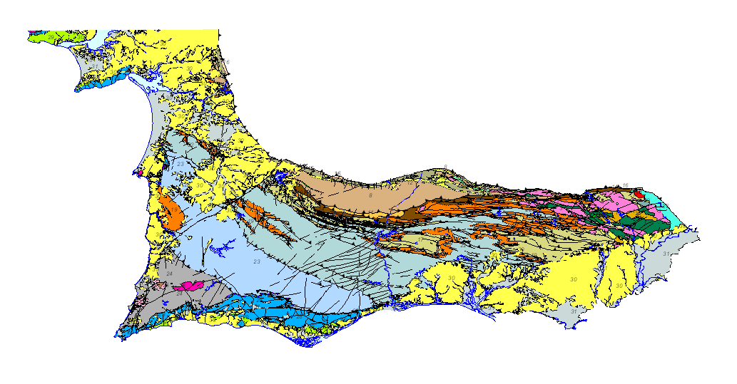
Geological map of the South Portuguese Zone. Scale 1:400.000. 2020 edition.
Geological map of the South Portuguese Zone, at a scale of 1:400,000, in which the geological legend on both sides of the border has been harmonized, with unified criteria between Spain and Portugal. This cartography is a product resulting from the GEO_FPI project: GEO_FPI: cross-border observatory for the geo-economic evaluation of the Iberian Pyrite Belt, financed by the European Regional Development Fund (ERDF) within the program INTERREG V-A Spain– Portugal (POCTEP) 2014-2020. The main beneficiary of the project is the Geological Survey of Spain (IGME-CSIC). Additionally, the General Directorate of Industry, Energy and Mines of the Ministry of Employment, Enterprise and Commerce of the Andalusian Government (JA) and the Portuguese National Laboratory for Energy and Geology (LNEG) and the Municipal Chamber of Aljustrel (CMA) are partners of the project.
Simple
- Alternate title
-
GEO_FPI_GEOLOGICO400
- Date (Creation)
- 2020-06-01
- Date (Publication)
- 2020-06-01
- Citation identifier
- / ESPIGMEGEOFPIGEOLOGICO400
- Purpose
-
The main objective of the map is the harmonization of the geological cartography at a 1:400000 scale between Spain and Portugal in the area of the South-Portuguese Zone (ZSP).
- Credit
-
IGME STANDARDS, DIRECTION AND SUPERVISION IGME Authors: Geological Cartography: Palaeozoic and Geochronology: Alejandro Díez Montes; Mesozoic and Cenozoic: Juan Julián Huerta Carmona. GIS: Ana Sevillano Matilla, Marta Criado Valdés (eGeoMapping). Authors LNEG: Geological Cartography: Paleozoic: João X. Matos, Luís Albardeiro, José T. Oliveira, Igor Morais, Paulo Fernandes, Carlos Inverno; Mesozoic: Susana Machado; Cenozoic: Ruben Dias, Ricardo Ressurreição. Palynology: Zélia Pereira, Márcia Mendes. Geochronology: Rita Solá, Luís Albardeiro, Rute Salgueiro. GIS: Pedro Gonçalves, Sara Santos. Project coordination: María Teresa López López
- Status
- Completed
- Point of contact
-
Organisation name Individual name Electronic mail address Role Geological Survey of Spain (IGME-CSIC)
Alejandro Díez Montes
Author National Energy and Geology Laboratory, I.P. (LNEG)
João Xavier Matos
Author
- Maintenance and update frequency
- Not planned
-
IGME Thesausus
-
-
Alentejo
-
Algarve
-
Andalusia
-
Cartography
-
Geology
-
Chronostratigraphy
-
Mineralogical deposits
-
Quarries
-
Spain
-
Portugal
-
- Keywords
-
-
400K
-
- Keywords
-
-
Industrial rocks and minerals
-
- Keywords
-
-
Iberian Pyritic Belt Cinturão Pyritic Ibérico.
-
- Keywords
-
-
Surportuguese zone
-
- Keywords
-
-
IGME
-
- Keywords
-
-
LNEG
-
- Keywords
-
-
EGDI
-
- Specific usage
-
Geological mapping, mineral resource research, planning, environment, mining
- User contact info
-
Organisation name Individual name Electronic mail address Role Spanish Geological Survey (IGME-CSIC)
Point of contact
- Access constraints
- Other restrictions
- Other constraints
- No limitations on public access
- Use constraints
- Other restrictions
- Other constraints
-
LICENCE OF USE: Conditions of public use and dissemination of information for the re-use of IGME data. https://www.igme.es/condiciones-de-uso/
- Use constraints
- Other restrictions
- Spatial representation type
- Vector
- Denominator
- 400000
- Language
- Spanish; Castilian
- Character set
- UTF8
- Topic category
-
- Geoscientific information
))
- Extent type code
- Yes
- Geographic identifier
- ES
- Unique resource identifier
- EPSG:3857
- Unique resource identifier
- CRS:84
- Unique resource identifier
- EPSG:4258
- Unique resource identifier
- EPSG:4326
- Unique resource identifier
- EPSG:4230
- Unique resource identifier
- EPSG:23028
- Unique resource identifier
- EPSG:23029
- Unique resource identifier
- EPSG:23030
- Unique resource identifier
- EPSG:23031
- Unique resource identifier
- EPSG:25828
- Unique resource identifier
- EPSG:25829
- Unique resource identifier
- EPSG:25830
- Unique resource identifier
- EPSG:25831
- Unique resource identifier
- EPSG:102100
- Distribution format
-
Name Version Shape file
No se aplica
Web Map Service WMS
1.3.0
Mapa digital: PDF - Portable Document Format
-
Joint Photographic Group Format JPEG
No se aplica
Tagged Image File FormatTIFF
No se aplica
Distributor
- Distributor contact
-
Organisation name Individual name Electronic mail address Role Geological Survey of Spain (IGME-CSIC)
Distributor
- Fees
-
Distribución a través de la web
- Distributor contact
-
Organisation name Individual name Electronic mail address Role Technical Vice-Directorate of Geological Information Systems of the Geological Survey of Spain (IGME-CSIC)
Distributor
- OnLine resource
-
Protocol Linkage Name OGC:WMS-1.3.0-http-get-capabilities
http://mapas.igme.es/gis/services/GeoFPI/GEOFPI_GEOLOGICO400/MapServer/WMSServer?request=getcapabilities&service=wms&version=1.3.0 WMS visualisation service of the Geological Map of the South Portuguese Area at 1:400.000 scale
WWW:LINK-1.0-http--link
http://mapas.igme.es/gis/rest/services/GeoFPI/GEOFPI_GEOLOGICO400/MapServer ArcGIS Server service of the Geological Map of the South Portuguese Area at 1:400.000 scale
http://info.igme.es/catalogo/ Search for the Geological Map of the South-Portuguese Area at scale 1:400.000 in the project Geo_FPI - Cross-border Observatory for the geo-economic valorisation of the Iberian Pyritic Belt.
- Hierarchy level
- Dataset
Conformance result
Conformance result
- Title
-
Commission Regulation (EC) No 1205/2008 of 3 December 2008 laying down detailed rules for the implementation of Directive 2007/2/EC of the European Parliament and of the Council as regards metadata
- Date (Publication)
- 2008-12-04
- Explanation
-
Consult the regulation
- Pass
- Yes
- Statement
-
Geological map of the South Portuguese Zone, at a scale of 1:400,000, in which the geological legend on both sides of the border has been harmonized, with unified criteria between Spain and Portugal. This cartography is a product resulting from the GEO_FPI project: GEO_FPI: cross-border observatory for the geo-economic evaluation of the Iberian Pyrite Belt
Metadata
- File identifier
- ESPIGMEGEOFPIGEOLOGICO40020201110 XML
- Metadata language
- Spanish; Castilian
- Character set
- UTF8
- Hierarchy level
- Dataset
- Date stamp
- 2025-05-30T07:50:31.711495Z
- Metadata standard name
-
Reglamento (CE) Nº 1205/2008 de Inspire, "Perfil IGME"
- Metadata standard version
-
2.0
- Metadata author
-
Organisation name Individual name Electronic mail address Role Geological Survey of Spain (IGME-CSIC)
Leticia Vega Martín
Point of contact
- Other language
-
Language Character encoding English UTF8 Portuguese UTF8 Spanish; Castilian UTF8
)))