 Catalogo de metadatos IGME-CSIC
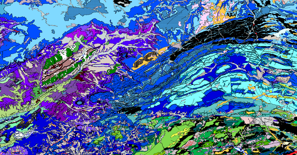
CONTINUOUS GEOLOGICAL MAPPING, ZONE 1800 PREBETIC ZONE AND TABULAR COVER
GEOLOGICAL CARTOGRAPHY is the representation of surface materials on the basis of their lithological, stratigraphic, structural, chronological, etc. characteristics. It is composed of the following levels of information: Z1800MRGEO: Cartographic units, differentiated geological enclosures; Z1800MPGEO: Geological enclosure labels; Z18006MLGEO: Auxiliary anchor lines of geological polygon labels; Z1800MLCON: Contact and fault lines. Linear entities of diverse origin; Z1800MPBUZ: Points and labels of point entities and structural measures.
Simple
- Alternate title
-
CONTINUOUS GEOLOGICAL MAP OF THE PREBETIC ZONE AND TABULAR COVER
- Date (Creation)
- 2006-07-01
- Date (Publication)
- 2011-12-31
- Citation identifier
-
ESPIGMEGEODE50Z1800
Identification of the Geological Survey of Spain (IGME). Documentation Centre 2009-01-01
- Presentation form
- Hardcopy map
- Presentation form
- Digital map
- Purpose
-
This CARTOGRAPHY is the result of the GEODE Continuous Geological Mapping Plan, it solves the problems of continuity in sheet edges of the previous MAGNA 50.000 series. It unifies criteria and offers a unique legend for each major region.
- Credit
-
Martín-Serrano García, A.; Díaz de Neira Sánchez, J.A.; Gómez Sainz de Aja, J.A.; Molinero Molinero, R.;
- Status
- en desarrollo
- Point of contact
-
Organisation name Individual name Electronic mail address Role Instituto Geológico y Minero de España (IGME-CSIC)
Principal investigator Instituto Geológico y Minero de España (IGME-CSIC)
José Alberto Díaz de Neira Sánchez
Originator Prointec
Juan Antonio Gómez Sainz de Aja
Originator Profesional libre
Ricardo Molinero Molinero
Originator Instituto Geológico y Minero de España (IGME-CSIC)
Margarita Sanabria Pavón
Processor Instituto Geológico y Minero de España (IGME-CSIC)
Javier Navas Madrazo
Processor Instituto Geológico y Minero de España (IGME-CSIC)
Distributor
- Maintenance and update frequency
- quaterly
- Maintenance note
-
The updating of the data is carried out at the request of the person in charge of the IGME assigned to this area. Depending on the magnitude of the modifications, there are different editing protocols for the alteration of the current data.
-
IGME Thesaurus
-
-
Geological map
-
Fault
-
Dip
-
Boundary
-
Fold axis
-
Legend
-
Prebético
-
Tabular cover
-
Geology
-
Stratigraphy
-
Mining
-
Chronostratigraphy
-
- Discipline
-
-
Geology
-
Stratigraphy
-
Mining
-
Chronostratigraphy
-
- Keywords
-
- Specific usage
-
Geological Cartography, Cartographic editing, Natural resources research, Planning, Geotechnics, Environment, etc.
- User contact info
-
Organisation name Individual name Electronic mail address Role Instituto Geológico y Minero de España (IGME-CSIC)
Point of contact
- Access constraints
- Other restrictions
- Other constraints
- No limitations on public access.
- Use constraints
- Other restrictions
- Other constraints
-
LICENCE OF USE: Conditions of public use and dissemination of information for the re-use of IGME data. http://www.igme.es/Ayuda/CondiUso.htm
- Spatial representation type
- Vector
- Denominator
- 50000
- Language
- Spanish; Castilian
- Character set
- UTF8
- Topic category
-
- Geoscientific information
- Description
-
Spain
))
- Extent type code
- Yes
- Geographic identifier
- ES
- Unique resource identifier
- EPSG:4258 (ETRS89 coordenadas geográficas)
- Unique resource identifier
- EPSG:23028 (ED50 / UTM zone 28Pico de las Nieves))
- Unique resource identifier
- EPSG:23029 (ED50 / UTM zone 29N)
- Unique resource identifier
- EPSG:23030 (ED50 / UTM zone 30N)
- Unique resource identifier
- EPGS:23031 (ED50 / UTM zone 31N)
- Unique resource identifier
- EPSG:3042 (ETRS89 TM 30N)
- Unique resource identifier
- EPGS:4230
- Distribution format
-
Name Version RASTER: JPG Con fichero de georeferenciación
Arcgis 9.2
VECTORIAL: SHAPE FILE (Uso restringido)
Arcgis 9.2
Web Map Service WMS
1.3.0
Distributor
- Distributor contact
-
Organisation name Individual name Electronic mail address Role Instituto Geológico y Minero de España (IGME-CSIC)
Distributor
- Fees
-
Acceso a servicios de mapas desde INFOIGME: Portal de Cartografía Geocientífica Digital
- Fees
-
Distribución a través de la web gratuita
- Distributor format
-
Name Version Joint Photographic Group Format JPEG
Arcgis 9.2
Mapa digital: SHP - ArcView ShapeFile
Arcgis 9.2
Web Map Service WMS
1.3.0
Distributor
- Distributor contact
-
Organisation name Individual name Electronic mail address Role Vicedirección Técnica de Sistemas de Información Geológica del Instituto Geológico y Minero del España (IGME-CSIC)
Distributor
- Distributor format
-
Name Version Servicio web: WMS - Web Map Service
1.3.0
- OnLine resource
-
Protocol Linkage Name OGC Web Map Service http://mapas.igme.es/gis/services/Cartografia_Geologica/IGME_Geode_50/MapServer/WMSServer?REQUEST=getcapabilities&SERVICE=WMS&VERSION=1.3.0 WMS visualisation service of the Continuous Geological Map of Spain, GEODE at scale 1:50.000
WWW:LINK-1.0-http--related
http://info.igme.es/cartografiadigital/geologica/geodezona.aspx?Id=Z1800&language=es Information and consultation the Geological Map of Spain, GEODE - Zone Z1800 (PREBETIC AND TABULAR SHELTER ZONE) at scale 1:50.000
https://info.igme.es/visor/ Information from the Geological Map of Spain, GEODE - Zone 1800 (PREBETIC ZONE AND TABULAR SHELTER) at scale 1:50.000
http://info.igme.es/catalogo/ Search for the Geological Map of Spain, GEODE Zone 1800 (PREBETTIC AND TABULAR COVER AREA) at scale 1:50.000
http://info.igme.es/cartografiadigital/datos/geode/docs/solicitud_informacion_GEODE.pdf Offline access to the Geological Map of Spain, GEODE Zone 1800 (PREBETIC ZONE AND TABULAR SHELTER) at scale 1:50.000
- Hierarchy level
- Dataset
Conformance result
Conformance result
- Statement
-
This Continuous Cartography was made WITHIN THE GEODE PLAN from the pre-existing MAGNA E.1:50.000 series, improved with more recent geological cartographies made by the IGME as updates of the MAGNA (1:50.000 of Onteniente, Calasparra and Cieza). This work has been carried out with the main collaboration of Juan Antonio Gómez, José Alberto Díaz de Neira and Ricardo Molinero (GEOPRIN), under the technical supervision of the IGME.
- Description
-
Generation of original dataset
- Date / Time
- 2012-02-08T12:00:00
- Description
-
Uniform data set processing
- Date / Time
- 2012-09-18T12:00:00
- Description
-
Integration in BDD
- Date / Time
- 2015-10-12T12:00:00
- Description
-
Publication on the internet
- Date / Time
- 2012-10-12T12:00:00
- Description
-
The Continuous Cartography was made WITHIN THE GEODE PLAN from the pre-existing MAGNA E.1:50.000 series, improved with more recent geological cartographies made by the IGME as updates of the MAGNA (1:50.000 of Onteniente, Calasparra and Cieza). This work has been carried out with the main collaboration of Juan Antonio Gómez, José Alberto Díaz de Neira and Ricardo Molinero (GEOPRIN), under the technical supervision of the IGME.
- Denominator
- 50000
- Title
-
Geological Map of Spain at scale 1:50.000 MAGNA (IGME)
- Alternate title
-
MAGNA
- Date (Creation)
- 1972-01-01
Citation identifier
- Cited responsible party
-
Organisation name Individual name Electronic mail address Role Instituto Geológico y Minero de España (IGME-CSIC)
Robador Moreno, Alejandro
Originator
- Presentation form
- Hardcopy document
- Presentation form
- Hardcopy map
Metadata
- File identifier
- ESPIGMEGEODE50Z180020210405 XML
- Metadata language
- Spanish; Castilian
- Character set
- UTF8
- Parent identifier
-
Cartografía Geológica Continua Escala 1:50.000, GEODE
ESPIGMEGEODE20220520
- Hierarchy level
- Dataset
- Date stamp
- 2025-04-04T11:36:42.42827Z
- Metadata standard name
-
Reglamento (CE) Nº 1205/2008 de Inspire, "Perfil IGME"
- Metadata standard version
-
TG 2.0
- Metadata author
-
Organisation name Individual name Electronic mail address Role Instituto Geológico y Minero de España (IGME-CSIC)
Leticia Vega Martín
Point of contact
- Other language
-
Language Character encoding English UTF8 Spanish; Castilian UTF8
)))