 Catalogo de metadatos IGME-CSIC
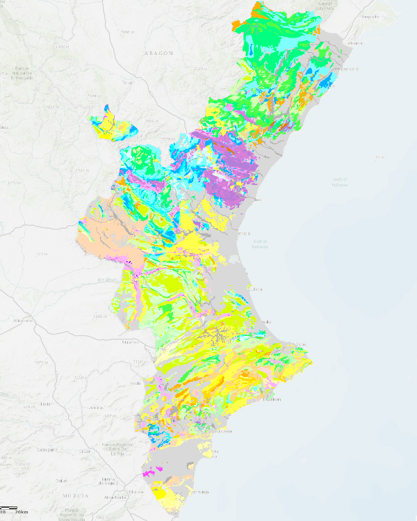
Síntesis Geológica de la Comunidad Valenciana a escala 1:400.000
Geological Synthesis of the Valencian Community at scale 1:400.000
Mapa con las unidades cronolitoestratigráficas de la Comunidad Valenciana acompañado de fallas y estructuras de plegamiento. Es una síntesis geológica unificada realizada a partir de cartografías del IGME en ese territorio a escala 1:200.000 y 1:50.000
Map with the chronolithostratigraphic units of the Valencian Community accompanied by faults and folding structures. It is a unified geological synthesis based on IGME maps of this territory at 1:200.000 and 1:50.000 scale.
Simple
-
Título alternativoAlternate title
-
GeoComunidadValenciana 400
GeoComunidadValenciana 400
-
Date (Creation)Fecha (Creación)
- 2002-01-01
-
Date (Publication)Fecha (Publicación)
- 2003-01-01
-
Citation identifierIdentificador del Contacto
- IGME-CSIC / ESPIGMEGEOCOMVALENCIANA400
-
Citation identifierIdentificador del Contacto
-
90105
Identificador en el Centro de Documentación del Instituto Geológico y Minero de EspañaIdentification of the Documentation Centre of Geological Survey of Spain
-
Presentation formFormulario de presentación
-
Digital mapMapa digital
-
PropósitoPurpose
-
El mapa de síntesis geológica de la Comunidad de Valencia responde a las directrices y objetivos que se recogen el "Plan Director Básico de los recursos Minerales Naturales de la Comunidad Valenciana" y cuyo primer objetivo es "potenciar el desarrollo minero sostenible, haciendo compatible el enfoque económico de un óptimo beneficio de los recursos con una mínima afección al medio ambiente".
Este mapa es una base para la identificación de las zonas potencialmente aptas para la concentración de recursos así como para la representación del inventario de indicios y explotaciones minerales de la comunidad.
The geological synthesis map of the Community of Valencia responds to the guidelines and objectives set out in the "Basic Master Plan for the Natural Mineral Resources of the Community of Valencia", the first objective of which is "to promote sustainable mining development, making the economic approach compatible with the optimum benefit of resources with a minimum impact on the environment".
This map is a basis for the identification of areas potentially suitable for the concentration of resources as well as for the representation of the inventory of indications and mineral exploitations in the community.
-
CréditoCredit
-
Normas, dirección y realización del IGME
Organismo cofinaciador: Conselleria de Industria y Comercio de la Generalitat Valenciana.
Jefe de Proyecto: Carmen Marchán Sanz
Autores:
Esther Alberruche del Campo
José Manuel Baltuille Martín
Daniel Barettino Fraile
Jesús Gómez de las Heras Gandullo
Guillermo Ortiz Figueroa
Juan Ignacio Pinuaga Espejel
Pedro Ruiz Reig
Javier Rubio Navas
Rogelio Urbano Vicente
Standards, direction and implementation of the IGME
Co-financing body: Conselleria de Industria y Comercio de la Generalitat Valenciana.
Project Manager:
Carmen Marchán Sanz
Authors:
Esther Alberruche del Campo
José Manuel Baltuille Martín
Daniel Barettino Fraile
Jesús Gómez de las Heras Gandullo
Guillermo Ortiz Figueroa
Juan Ignacio Pinuaga Espejel
Pedro Ruiz Reig
Javier Rubio Navas
Rogelio Urbano Vicente
-
StatusEstado
-
CompletedTerminado
- Point of contact
-
Organisation name Individual name Electronic mail address Role Instituto Geológico y Minero de España (IGME-CSIC)
Geological Survey of Spain (IGME-CSIC)
Point of contactPunto de Contacto
-
Maintenance and update frequencyMantenimiento y frecuencia de actualización
-
Not plannedSin planificar
-
Tesauro IGME
IGME Thesaurus
-
-
Geología general.geología
General geology.geology
-
Geología general.litología
General geology.lithology
-
Geología estructural.falla
Structural geology.fault
-
Geología estructural.plegamiento
Structural geology.folding
-
- Keywords
-
-
Comunidad Valenciana
Valencian Community
-
-
GEMET
GEMET
-
-
MEDIO NATURAL, MEDIO ANTRÓPICO
NATURAL ENVIRONMENT, ANTHROPIC ENVIRONMENT
-
LITOSFERA (suelo, procesos geológicos)
LITHOSPHERE (soil, geological processes)
-
litosfera
lithosphere
-
rocas
rocks
-
- Keywords
-
-
Uso específicoSpecific usage
-
El mapa de síntesis geológica de la provincia de Valencia responde a las directrices y objetivos que se recogen el "Plan Director Básico de los recursos Minerales Naturales de la Comunidad Valenciana" y cuyo primer objetivo es "potenciar el desarrollo minero sostenible, haciendo compatible el enfoque económico de un óptimo beneficio de los recursos con una mínima afección al medio ambiente".
Este mapa es una base para la identificación de las zonas potencialmente aptas para la concentración de recursos así como para la representación del inventario de indicios y explotaciones minerales de la provincia.
The geological synthesis map of the province of Valencia responds to the guidelines and objectives set out in the "Basic Master Plan for the Natural Mineral Resources of the Valencian Community", the first objective of which is "to promote sustainable mining development, making the economic approach compatible with the optimum benefit of resources with a minimum impact on the environment".
This map is a basis for the identification of areas potentially suitable for the concentration of resources as well as for the representation of the inventory of indications and mineral exploitations in the province.
- User contact info
-
Organisation name Individual name Electronic mail address Role Instituto Geológico y Minero de España (IGME-CSIC)
Geological Survey of Spain (IGME-CSIC)
Point of contactPunto de Contacto
-
Access constraintsRestricciones de Acceso
-
Other restrictionsOtras restricciones
-
Otras limitacionesOther constraints
-
Sin limitaciones al acceso público.No limitations on public access.
-
Use constraintsRestricciones de uso
-
Other restrictionsOtras restricciones
-
Otras limitacionesOther constraints
-
LICENCIA DE USO: Condiciones de uso público y difusión de la información para la reutilización de los datos IGME. http://www.igme.es/condiciones-de-uso.htm
LICENCE OF USE: Conditions of public use and dissemination of information for the re-use of IGME data. http://www.igme.es/condiciones-de-uso.htm
-
Spatial representation typeTipo de representación espacial
-
VectorVector
-
DenominatorDenominador
- 400000
-
LanguageIdioma
- Spanish; Castilian
-
Character setCodificación
-
UTF8UTF8
-
Topic categoryCategoría temática
-
-
Geoscientific informationInformación geocientífica
-
))
-
Extent type codeCódigo del tipo de extensión
- Yes
-
Geographic identifierIdentificador geográfico
-
ES
-
Identificador único del recursoUnique resource identifier
-
EPSG:23030EPSG:23030
-
Identificador único del recursoUnique resource identifier
-
EPSG:6230EPSG:6230
-
Identificador único del recursoUnique resource identifier
-
EPSG:4258EPSG:4258
- Distribution format
-
Name Version Shape file
No se aplica
Web Map Service WMS
1.3.0
Mapa digital: PDF - Portable Document Format
-
Joint Photographic Group Format JPEG
No se aplica
Tagged Image File FormatTIFF
No se aplica
Distributor
Distribuidor
- Distributor contact
-
Organisation name Individual name Electronic mail address Role Instituto Geológico y Minero de España (IGME-CSIC)
Geological Survey of Spain (IGME-CSIC)
DistributorDistribuidor
- Fees
-
Distribución a través de la web
- Distributor contact
-
Organisation name Individual name Electronic mail address Role Vicedirección Técnica de Sistemas de Información Geológica del Instituto Geológico y Minero del España (IGME-CSIC)
Technical Vice-Directorate of Geological Information Systems of the Geological Survey of Spain (IGME-CSIC)
DistributorDistribuidor
- OnLine resource
-
Protocol Linkage Name OGC:WMS-1.3.0-http-get-capabilities
https://mapas.igme.es/gis/services/Cartografia_Geologica/IGME_GeologicoCValenciana_400/MapServer/WMSServer?request=getcapabilities&service=wms&sversion=1.3.0 Servicio de visualización WMS del del Mapa de síntesis geológica de la Comunidad de Valencia 1:400.000
WMS visualisation service of the Geological Synthesis Map of the Community of Valencia 1:400.000
WWW:LINK-1.0-http--link
https://mapas.igme.es/gis/services/Cartografia_Geologica/IGME_GeologicoCValenciana_400/MapServer/WMSServer Servicio de ArcGIS Server del Mapa de síntesis geológica de la Comunidad de Valencia 1:400.000
ArcGIS Server service of the Geological Synthesis Map of the Community of Valencia 1:400.000
http://info.igme.es/catalogo/ Busqueda del Mapa de síntesis geológica de la Comunidad de Valencia 1:400.000
Search for the Geological Synthesis Map of the Community of Valencia 1:400.000
-
Hierarchy levelJerarquía
-
DatasetConjunto de datos
Conformance result
Conformidad del Resultado
-
Date (Publication)Fecha (Publicación)
- 2009-10-19
-
ExplicaciónExplanation
-
ConformeConformant
-
PassAprobado
- Yes
Conformance result
Conformidad del Resultado
-
Date (Publication)Fecha (Publicación)
- 2008-12-03
-
ExplicaciónExplanation
-
ConformeConformant
-
PassAprobado
- Yes
Conformance result
Conformidad del Resultado
-
Date (Publication)Fecha (Publicación)
- 2010-12-08
Citation identifier
Identificador del Contacto
-
ExplicaciónExplanation
-
Consultar el reglamento
Consult the regulation
-
PassAprobado
- No
-
DeclaraciónStatement
-
Mapa de síntesis geológica unificada de la Comunidad de Valencia realizada a partir de cartografías del IGME en ese territorio a escala 1:200.000 y 1:50.000, con las unidades cronolitoestratigráficas de la Comunidad Valenciana acompañado de fallas y estructuras de plegamiento
Unified geological synthesis map of the Community of Valencia based on 1:200.000 and 1:50.000 scale maps of the IGME in that territory, with the chronolithostratigraphic units of the Community of Valencia together with faults and folding structures.
Metadata
-
File identifierIdentificador del fichero
- ESPIGMEGEOCOMUNIDADVALENCIANA4002010090390105 XML
-
Metadata languageIdioma del metadato
- Spanish; Castilian
-
Character setCodificación
-
UTF8UTF8
-
Hierarchy levelJerarquía
-
DatasetConjunto de datos
-
Date stampFecha
- 2026-05-22T11:28:23.598598Z
- Metadata standard name
-
Reglamento (CE) Nº 1205/2008 de Inspire, "Perfil IGME"
- Metadata standard version
-
2.0
- Metadata author
-
Organisation name Individual name Electronic mail address Role Instituto Geológico y Minero de España (IGME-CSIC)
Geological Survey of Spain (IGME-CSIC)
Leticia Vega Martín
Point of contactPunto de Contacto
- Other language
-
Language Character encoding EnglishEnglishUTF8UTF8Spanish; CastilianSpanish; CastilianUTF8UTF8
)))