 Catalogo de metadatos IGME-CSIC
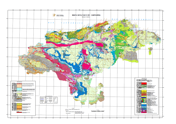
Mapa Geológico-Minero de Cantabria a escala 1:100.000
Geological Map of Cantabria at scale 1:100.000
Mapa con las unidades cronolitoestratigráficas de la zona cubierta por la hoja separadas por distintos tipos de contactos: normal o concordante, discordante, intrusivo y de otra índole. La estructura tectónica se representa mediante las trazas cartográficas de los pliegues, la orientación y buzamiento de los elementos planares y lineares contenidos en las rocas, así como por la relación estructural -mediante fallas y cabalgamientos- entre los conjuntos rocosos diferenciados cartográficamente. El mapa está acompañado de la leyenda litoestratigráfica y los signos convencionales.
Map showing the chronolithostratigraphic units of the area covered by the sheet separated by different types of contacts: normal or concordant, discordant, intrusive and other. The tectonic structure is represented by the cartographic traces of folds, the orientation and dip of planar and linear elements contained in the rocks, as well as by the structural relationship - by means of faults and thrusts - between the rock assemblages differentiated cartographically. The map is accompanied by the lithostratigraphic legend and conventional signs.
Simple
-
Título alternativoAlternate title
-
GeoCantabria 100
GeoCantabria 100
-
Date (Creation)Fecha (Creación)
- 1989-01-01
-
Date (Publication)Fecha (Publicación)
- 1990-01-01
- Edition
-
1ª Edición
-
Edition dateFecha de edición
- 1990-01-01
-
Citation identifierIdentificador del Contacto
- 11288
-
Presentation formFormulario de presentación
-
Digital mapMapa digital
-
Presentation formFormulario de presentación
-
Hardcopy documentDocumento en papel
-
Presentation formFormulario de presentación
-
Hardcopy mapMapa en papel
-
PropósitoPurpose
-
El mapa Geológico-Minero de Cantabria se ha realizado al amparo del Convenio-Marco de Asistencia Técnica con fecha de 29 de Marzo de 1984 suscrito entre el Instituto Geológico y Minero de España y la Diputación Regional de Cantabria.
El objetivo general es disponer de información geológica de la Comunidad de Cantabria de forma conjunta y continua para la planificación regional en aspectos relacionados con los recursos geológicos, los riesgos geológicos, protección ambiental y redes de comunicaciones. De forma específica este mapa se ha elaborado para analizar, enmarcar y representar los recursos minerales y energéticos de la Comunidad.
The Geological-Mining Map of Cantabria has been carried out under the Technical Assistance Framework Agreement dated 29th March 1984 signed between the Geological Survey of Spain (IGME) and the Regional Council of Cantabria.
The general objective is to provide joint and continuous geological information on the Community of Cantabria for regional planning in aspects related to geological resources, geological risks, environmental protection and communications networks. Specifically, this map has been drawn up to analyse, frame and represent the mineral and energy resources of the Region.
-
CréditoCredit
-
Se ha realizado bajo la supervisión del Servicio de Recursos Mineros y Energéticos de la Consejería de Turismo, Transportes y Comunicaciones e Industria de la Diputación Regional de Cantabria, por el Instituto Geológico y Minero de España (IGME), al amparo del convenio-marco de asistencia técnica entre ambas instituciones de 1984.
Autores: Mesozoico y Terciario: Alejandro Robador Moreno
Paleozoico:
Liébana y Unidades Palentinas: Nemesio Heredia Carballo
L. Roberto Rodríguez Fernández
Picos de Europa: Jorge Manríquez García (Univ. Oviedo)
It has been carried out under the supervision of the Mining and Energy Resources Service of the Department of Tourism, Transport and Communications and Industry of the Regional Council of Cantabria, by the Geological Survey of Spain (IGME), under the framework agreement for technical assistance between the two institutions in 1984.
Authors: Mesozoic and Tertiary: Alejandro Robador Moreno
Palaeozoic:
Liebana and Palencia Units: Nemesio Heredia Carballo
L. Roberto Rodríguez Fernández
Picos de Europa: Jorge Manríquez García (Univ. Oviedo)
-
StatusEstado
-
CompletedTerminado
- Point of contact
-
Organisation name Individual name Electronic mail address Role Instituto Geológico y Minero de España (IGME-CSIC)
Geological Survey of Spain (IGME-CSIC)
Alejandro Robador Moreno
Point of contactPunto de Contacto
-
Maintenance and update frequencyMantenimiento y frecuencia de actualización
-
Not plannedSin planificar
-
Tesauro IGME
IGME Thesaurus
-
-
Geología general
General geology
-
Geología general.geología
General geology.geology
-
Geología general.litología
General geology.litology
-
Geología estructural.falla
Structural geology.fault
-
Geología general.roca
General geology.rock
-
Estratigrafía
Stratigraphy
-
Cronoestratigrafía
Chronostratigraphy
-
Roca
Rock
-
Roca sedimentaria
Sedimentary rock
-
Sistemática de rocas metamórficas.roca metamórfica
Systematics of metamorphic rocks.metamorphic rock
-
Roca cristalina
Crystalline rock
-
Roca ígnea
Igneous rock
-
Geomorfología y Geología del Cuaternario
Quaternary Geomorphology and Geology
-
Formación superficial
Surface formation
-
Geología estructural
Structural geology
-
Plegamiento
Folding
-
Sistemática de Estratigrafía
Systematics of stratigraphy
-
Silúrico
Silurian
-
Devónico
Devonian
-
Carbonífero
Carboniferous
-
Mesozoico
Mesozoic
-
Triásico
Triassic
-
Jurásico
Jurassic
-
Cretácico
Cretaceous
-
Neógeno
Neogene
-
Cuaternario
Quaternary
-
-
CEOLocation
CEOLocation
-
-
COUNTRIES.SPAIN
COUNTRIES.SPAIN
-
- Keywords
-
-
España
Spain
-
Cantabria
Cantabria
-
-
GEMET
GEMET
-
-
MEDIO NATURAL, MEDIO ANTRÓPICO
NATURAL ENVIRONMENT, ANTHROPIC ENVIRONMENT
-
LITOSFERA (suelo, procesos geológicos)
LITHOSPHERE (soil, geological processes)
-
litosfera
lithosphere
-
rocas
rocKs
-
ACTIVIDADES Y PRODUCTOS HUMANOS, EFECTOS SOBRE EL MEDIO AMBIENTE
HUMAN ACTIVITIES AND PRODUCTS, EFFECTS ON THE ENVIRONMENT
-
RECURSOS (uso de los recursos)
RESOURCES (resource use)
-
recursos
resources
-
recursos naturales
natural resources
-
recursos minerales
mineral resources
-
- Keywords
-
-
Access constraintsRestricciones de Acceso
-
Other restrictionsOtras restricciones
-
Otras limitacionesOther constraints
-
Sin limitaciones al acceso públicoNo limitations on public access
-
Use constraintsRestricciones de uso
-
Other restrictionsOtras restricciones
-
Otras limitacionesOther constraints
-
LICENCIA DE USO: Condiciones de uso público y difusión de la información para la reutilización de los datos IGME. https://www.igme.es/condiciones-de-uso/
LICENSE OF USE: Conditions of public use and dissemination of information for the reuse of data. https://www.igme.es/condiciones-de-uso/
-
TítuloTitle
-
Mapa Geológico de España a escala 1:50.000, MAGNA
Geological Map of Spain at a scale of 1:50.000, MAGNA
-
Date (Revision)Fecha (Revisión)
- 1991-01-01
- Cited responsible party
-
Organisation name Individual name Electronic mail address Role Instituto Geológico y Minero de España (IGME-CSIC)
Geological Survey of Spain (IGME-CSIC)
Point of contactPunto de Contacto
-
Aggregate DatasetindentifierIdentificador del Conjunto de Datos Agregado
- 20000
-
Association TypeTipo de asociación
-
Larger work citationCita de trabajo ampliada
-
Spatial representation typeTipo de representación espacial
-
VectorVector
-
DenominatorDenominador
- 100000
-
LanguageIdioma
- Spanish; Castilian
-
Character setCodificación
-
8859 Part 18859 Parte 1
-
DescripciónDescription
-
Cantabria
Cantabria
))
-
Información SuplementariaSupplemental Information
-
En formato digital sólo se encuentra el mapa geológico de Cantabria. En la versión publicada en papel, se acompaña de dos mapas más, que son el de minerales metálicos y energéticos y el de rocas y minerales industriales.
También existe publicada la memoria del proyecto de elaboración de los tres mapas. Contiene tres apartado descriptivos y diferenciados del la geología, los minerales metálicos y energéticos y las rocas y minerales industriales de Cantabria. Además se incluyen tres anexos con listados de indicios minerales metálicos y energéticos, de explotaciones e indicios de minerales y rocas industriales y de explotaciones e indicios de minerales y rocas industriales por sustancias y usos.
Los mapas y la memoria son consultables en el Portal de cartografiía y a través del Centro de Documentación.
Only the geological-mining map of Cantabria is available in digital format. In the paper version, it is accompanied by two more maps, one of metallic and energy minerals and the other of industrial rocks and minerals.
The report of the project for the elaboration of the three maps has also been published. It contains three descriptive and differentiated sections on the geology, metallic and energy minerals and industrial rocks and minerals of Cantabria. It also includes three annexes with lists of metallic and energetic mineral traces, of exploitations and traces of industrial minerals and rocks and of exploitations and traces of industrial minerals and rocks by substances and uses.
Maps and the report can be consulted on the Cartography Portal and through the Documentation Centre.
-
Identificador único del recursoUnique resource identifier
-
EPSG:23030EPSG:23030
-
Identificador único del recursoUnique resource identifier
-
EPSG:6230EPSG:6230
-
Identificador único del recursoUnique resource identifier
-
EPSG:4258EPSG:4258
- Distribution format
-
Name Version Mapa digital: SHP - ArcView ShapeFile
8.2
Mapa digital: ARCC - Coverage of Arc-Info
8.2
Mapa digital: ARCE - ARC/INFO Export format
8.2
Mapa digital: PDF - Portable Document Format
Unknown
Mapa en papel
-
Servicio web: WMS - Web Map Service
1.3.0
Distributor
Distribuidor
- Distributor contact
-
Organisation name Individual name Electronic mail address Role Instituto Geológico y Minero de España (IGME-CSIC)
Geological Survey of Spain (IGME-CSIC)
DistributorDistribuidor
- Distributor format
-
Name Version Mapa digital: SHP - ArcView ShapeFile
Mapa digital: SHP - ArcView ShapeFile
8.2
Mapa digital: ARCC - Coverage of Arc-Info
Mapa digital: ARCC - Coverage of Arc-Info
-
Mapa digital: ARCE - ARC/INFO Export format
Mapa digital: ARCE - ARC/INFO Export format
-
Mapa digital: PDF - Portable Document Format
Mapa digital: PDF - Portable Document Format
-
Distributor
Distribuidor
- Distributor contact
-
Organisation name Individual name Electronic mail address Role Centro de Documentación del Instituto Geológico y Minero de España (IGME-CSIC)
DistributorDistribuidor
- Distributor format
-
Name Version Mapa en papel
Hardcopy map
---
Distributor
Distribuidor
- Distributor contact
-
Organisation name Individual name Electronic mail address Role Área de Sistemas de Información Geológica del Instituto Geológico y Minero del España (IGME-CSIC)
Geological Information Systems Area of the Geological Survey of Spain (IGME-CSIC)
DistributorDistribuidor
- Distributor format
-
Name Version Servicio web: WMS - Web Map Service
Servicio web: WMS - Web Map Service
1.3.0
- OnLine resource
-
Protocol Linkage Name OGC:WMS-1.3.0-http-get-capabilities
https://mapas.igme.es/gis/services/Cartografia_Geologica/IGME_GeologicoCantabria_100/MapServer/WMSServer?service=wms&request=getcapabilities&version=1.3.0 Enlace al GetCapabilities del servicio web donde se aloja el producto
Link to the GetCapabilities of the web service hosting the product
WWW:LINK-1.0-http--related
https://mapas.igme.es/Servicios/default.aspx#IGME_GeologicoCantabria_100 Enlace a la página del producto en la web del IGME
Link to the product page on the IGME web site
-
NameNombre
-
CDROMCDROM
-
Hierarchy levelJerarquía
-
DatasetConjunto de datos
Completeness commission
Comisión de Completitud
-
Nombre de la medidaName of measure
-
Fenómenos duplicados.
Duplicated phenomena
-
Descripción de la medidaMeasure description
-
Control geométrico y topológico mediante las herramientas de la aplicación SIG.
Geometric and topological control using the tools of the GIS application.
Conformance result
Conformidad del Resultado
-
TítuloTitle
-
Control geométrico y topológico mediante las herramientas de la aplicación SIG
Geometric and topological control using the tools of the GIS application.
-
Date (Revision)Fecha (Revisión)
- 1990-01-01
-
ExplicaciónExplanation
-
Tasa de error 0 %
Error rate 0 %
-
PassAprobado
- Yes
Completeness omission
Omisión de completitud
-
Nombre de la medidaName of measure
-
Falta de fenómenos
Lack of phenomena
-
Descripción de la medidaMeasure description
-
Chequeo visual aleatorio y cruce de información espacial con las tablas de atributos.
Visual spot check and cross-checking of spatial information with attribute tables.
Conformance result
Conformidad del Resultado
-
TítuloTitle
-
Chequeo visual aleatorio y cruce de información espacial con las tablas de atributos
Visual spot check and cross-checking of spatial information with attribute tables.
-
Date (Revision)Fecha (Revisión)
- 1990-01-01
-
ExplicaciónExplanation
-
Validación comparativa digital y chequeo visual comparativo del mapa original y el mapa digitalizado. Validación con tasa de error < 1%
Digital comparative validation and visual comparative check of the original map and the digitised map. Validation with error rate < 1%.
-
PassAprobado
- Yes
Conceptual consistency
Consistencia conceptual
-
Nombre de la medidaName of measure
-
Grado de aproximación de los datos digitales con el modelo conceptual. Distribución de fenómenos en clases.
Degree of approximation of the digital data with the conceptual model. Distribution of phenomena in classes.
-
Descripción de la medidaMeasure description
-
Verificación manual.
Manual verification
Conformance result
Conformidad del Resultado
-
TítuloTitle
-
Modelo de datos de la cartografía geológica MAGNA en formato digital.
MAGNA geological mapping data model in digital format.
-
Date (Revision)Fecha (Revisión)
- 2012-02-01
-
ExplicaciónExplanation
-
Comprobación de que la información digital concuerda con las normas que lo definen conceptualmente. Consultar la norma
Check that the digital information is consistent with the standards that conceptually define it. Consult the standard
-
PassAprobado
- Yes
Conceptual consistency
Consistencia conceptual
-
Nombre de la medidaName of measure
-
Grado de aproximación de los datos digitales con el modelo conceptual. Propiedades de los fenómenos
Degree of approximation of the digital data with the conceptual model. Properties of the phenomena
-
Descripción de la medidaMeasure description
-
Verificación automática.
Automatic verification
Conformance result
Conformidad del Resultado
-
TítuloTitle
-
Modelo de datos de la cartografía geológica MAGNA en formato digital.
MAGNA geological mapping data model in digital format.
-
Date (Publication)Fecha (Publicación)
- 2012-02-01
-
ExplicaciónExplanation
-
Comprobación de que la información digital concuerda con las normas que lo definen conceptualmente. Consultar la norma
Check that the digital information is consistent with the standards that conceptually define it. Consult the standard.
-
PassAprobado
- Yes
Conceptual consistency
Consistencia conceptual
-
Nombre de la medidaName of measure
-
Existencia de códigos fuera del rango establecido para cada atributo.
Existence of codes outside the established range for each attribute.
-
Descripción de la medidaMeasure description
-
Verificiación automática
Automatic verification
Conformance result
Conformidad del Resultado
-
TítuloTitle
-
Especificaciones para la digitalización de la cartografía geológica MAGNA.
Especificaciones para la digitalización de la cartografía geológica MAGNA.
-
Date (Revision)Fecha (Revisión)
- 2012-02-01
-
ExplicaciónExplanation
-
Comprobación de que la información digital concuerda con las normas que lo definen conceptualmente. Consultar la norma
Check that the digital information is consistent with the standards that conceptually define it. Consult the standard
-
PassAprobado
- Yes
Format consistency
Consistencia del formato
-
Nombre de la medidaName of measure
-
Grado de aproximación de los datos a la estructura física establecida.
Degree of approximation of the data to the established physical structure.
-
Descripción de la medidaMeasure description
-
Verificiación automática
Automatic verification
Conformance result
Conformidad del Resultado
-
TítuloTitle
-
Especificaciones para la digitalización de la cartografía geológica MAGNA.
Specifications for the digitisation of MAGNA geological mapping.
-
Date (Revision)Fecha (Revisión)
- 2012-02-01
-
ExplicaciónExplanation
-
Comprobación de que la información digital concuerda con las normas. Consultar la norma.
Check that the digital information is in accordance with the standards. Consult the standard.
-
PassAprobado
- Yes
Format consistency
Consistencia del formato
-
Nombre de la medidaName of measure
-
Grado de conformidad de los datos a las reglas topológicas definidas. Ausencia de contactos geológicos con alguno de sus extremos (nodos) sin conexión a otro nodo de otros contacto, una falla o un límite convencional.
Degree of conformity of the data to the defined topological rules. Absence of geological contacts with any of their ends (nodes) not connected to another node of another contact, a fault or a conventional boundary.
-
Descripción de la medidaMeasure description
-
Verificiación automática
Automatic verification
Conformance result
Conformidad del Resultado
-
TítuloTitle
-
Modelo de datos de la cartografía geológica MAGNA en formato digital.
MAGNA geological mapping data model in digital format.
-
Date (Revision)Fecha (Revisión)
- 2012-02-01
-
ExplicaciónExplanation
-
Comprobación de que la información digital concuerda con las normas. Consultar la norma.
Check that the digital information is in accordance with the standards. Consult the standard.
-
PassAprobado
- Yes
Format consistency
Consistencia del formato
-
Nombre de la medidaName of measure
-
Grado de conformidad de los datos a las reglas topológicas definidas. Ausencia de contactos geológicos que separen recintos pertenecientes a la misma unidad cartográfica
Degree of conformity of the data to the defined topological rules. Absence of geological contacts separating enclosures belonging to the same cartographic unit.
-
Descripción de la medidaMeasure description
-
Verificiación automática
Automatic verification
Conformance result
Conformidad del Resultado
-
TítuloTitle
-
Modelo de datos de la cartografía geológica MAGNA en formato digital.
MAGNA geological mapping data model in digital format.
-
Date (Revision)Fecha (Revisión)
- 2012-02-01
-
ExplicaciónExplanation
-
Comprobación de que la información digital concuerda con las normas. Consultar la norma.
Check that the digital information is in accordance with the standards. Consult the standard.
-
PassAprobado
- Yes
Absolute external positional accuracy
Precisión absoluta de la posición externa
-
Nombre de la medidaName of measure
-
Exactitud absoluta externa
External absolute accuracy
-
Descripción de la medidaMeasure description
-
Error cuadrático medio en el registro del mapa para digitalizar.
Mean square error in the registration of the map to be digitised.
Conformance result
Conformidad del Resultado
-
TítuloTitle
-
Error cuadrático medio en el registro del mapa para digitalizar
Mean square error in the registration of the map to be digitised.
-
Date (Revision)Fecha (Revisión)
- 1990-01-01
-
ExplicaciónExplanation
-
Comprobación de que el error posicional es menor al exigible atendiendo a la escala del mapa > 20
Mean square error in the registration of the map to be digitised.
-
PassAprobado
- Yes
Thematic classification correctness
Exactitud de la clasificación temática
-
Nombre de la medidaName of measure
-
Ausencia de errores en la asignación de las clases a los fenómenos.
Mean square error in the registration of the map to be digitised.
-
Descripción de la medidaMeasure description
-
Estudio comparativo con la cartografía original. Muestreo aleatorio
Comparative study with the original map. Random sampling
Conformance result
Conformidad del Resultado
-
TítuloTitle
-
Estudio comparativo con la cartografía original. Muestreo aleatorio
Comparative study with the original map. Random sampling
-
Date (Revision)Fecha (Revisión)
- 1990-01-01
-
ExplicaciónExplanation
-
Validación comparativa digital y chequeo visual comparativo del mapa original y el mapa digitalizado. Validación con tasa de error < 1%
Digital comparative validation and comparative visual check of the original map and the digitized map. Validation with an error rate of <1%
-
PassAprobado
- Yes
Thematic classification correctness
Exactitud de la clasificación temática
-
Nombre de la medidaName of measure
-
Ausencia de errores en la asignación de identificadores a las unidades cartográficas.
Mean square error in the registration of the map to be digitised.
-
Descripción de la medidaMeasure description
-
Estudio comparativo con mapa original.
Comparative study with original map.
Conformance result
Conformidad del Resultado
-
TítuloTitle
-
Estudio comparativo con mapa original.
Comparative study with original map.
-
Date (Revision)Fecha (Revisión)
- 1990-01-01
-
ExplicaciónExplanation
-
Validación comparativa digital y chequeo visual comparativo del mapa original y el mapa digitalizado. Tasa de error 1%. Superficie de error < 0,1% en las unidades cartográficas
Digital comparative validation and comparative visual check of the original map and the digitized map. Error rate 1%. Error area < 0.1% in the cartographic units
-
PassAprobado
- Yes
Non quantitative attribute accuracy
Precisión de atributos no cuantitativos
-
Nombre de la medidaName of measure
-
Ausencia de errores en la asignación de valores.
Mean square error in the registration of the map to be digitised.
-
Descripción de la medidaMeasure description
-
Estudio comparativo con mapa original
Comparative study with original map.
Conformance result
Conformidad del Resultado
-
TítuloTitle
-
Estudio comparativo con mapa original
Comparative study with original map.
-
Date (Revision)Fecha (Revisión)
- 1990-01-01
-
ExplicaciónExplanation
-
Validación comparativa digital y chequeo visual comparativo del mapa original y el mapa digitalizado. Tasa de error 1%. Superficie de error < 0,1% en las unidades cartográficas
Digital comparative validation and comparative visual check of the original map and the digitized map. Error rate 1%. Error area < 0.1% in the cartographic units
-
PassAprobado
- Yes
Conformance result
Conformidad del Resultado
-
Date (Publication)Fecha (Publicación)
- 2010-12-08
Citation identifier
Identificador del Contacto
-
ExplicaciónExplanation
-
Consultar el reglamento
Consult the regulations
-
PassAprobado
- No
-
DeclaraciónStatement
-
Mapa realizado principalmente sobre la información reflejada en el Mapa Geológico Nacional a escala 1:50.000 (segunda serie), MAGNA con la incorporación de datos procedentes de tesis doctorales y trabajos inéditos.
Digitalización realizada en el año 2002. Normalización y generación de ficheros simbolizados (.lyr) y cartografía, en versión 8.2 de ArcGIS, en el año 2003.
Map made mainly on the information reflected in the National Geological Map at a scale of 1:50.000 (second series), MAGNA with the incorporation of data from doctoral theses and unpublished works.
Digitisation carried out in 2002. Normalisation and generation of symbolised files (.lyr) and cartography, in version 8.2 of ArcGIS, in 2003..
-
DescripciónDescription
-
Recopilación y análisis de información previa:
Recopilación de la información geológica MAGNA y de los trabajos realizados en el área cubierta por la hoja efectuados con posterioridad a las hojas MAGNA.
Compilation and analysis of previous information:
Compilation of MAGNA geological information and of work carried out in the area covered by the sheet carried out subsequent to the MAGNA sheets.
-
DescripciónDescription
-
Realización del mapa:
Estudio de las unidades cartográficas y revisión de las muestras.
Elaboración de la leyenda Correlación entre las unidades cartográficas de las hojas MAGNA y la leyenda cronolitoestratigráfica del mapa a escala 1:100.000.
Ajuste espacial entre los límites de hojas.
Ajuste a la base topográfica seleccionada.
Trazado del mapa geológico a escala 1:100.000.
Production of the map:
Study of the cartographic units and revision of the samples.
Creation of the legend Correlation between the cartographic units of the MAGNA sheets and the chronolithostratigraphic legend of the map at a scale of 1:100,000
Spatial adjustment between sheet boundaries.
Adjustment to the selected topographic base.
Drawing of the geological map at a scale of 1:100.000.
-
DescripciónDescription
-
Proceso de digitalización de la información:
Análisis de las entidades presentes en la cartografía. Asignación de códigos.
Digitalización de contactos geológicos y fallas. Generación de los recintos que constituyen las unidades cartográficas. Digitalización del resto de entidades geológicas. Digitalización de la leyenda cronolitoestratigráfica.
Control de errores y corrección.
Process of digitalisation of the information:
Analysis of the entities present in the cartography. Assignment of codes.
Digitisation of geological contacts and faults. Generation of the enclosures that constitute the cartographic units. Digitisation of the rest of the geological entities. Digitisation of the chronolithostratigraphic legend.
Error control and correction.
-
DescripciónDescription
-
Se representan las unidades rocosas de la hoja separadas por distintos tipos de contactos, junto con la estructura tectónica fallas y trazas cartográficas de los pliegues, la orientación y buzamiento de los elementos planares y lineares contenidos en las rocas, singularidades estructurales y texturales de las rocas ígneas y metamórficas, puntos de agua, yacimientos e indicios minerales, presencia de fósiles y otros elementos de representación puntual.
The rock units of the sheet separated by different types of contacts are represented, together with the tectonic structure, faults and map traces of folds, the orientation and dip of planar and linear elements contained in the rocks, structural and textural singularities of igneous and metamorphic rocks, water points, mineral deposits and indications, presence of fossils and other elements of punctual representation..
-
DenominatorDenominador
- 50000
-
TítuloTitle
-
Mapa Geológico de España escala 1:50.000 MAGNA (Segunda serie 1ª edición)
Geological Map of Spain scale 1:50.000 MAGNA (Second series 1st edition)
-
Date (Revision)Fecha (Revisión)
- 1991-01-01
- Cited responsible party
-
Organisation name Individual name Electronic mail address Role Instituto Geológico y Minero de España (IGME-CSIC)
Geological Survey of Spain (IGME-CSIC)
OriginatorOrígenInstituto Geológico y Minero de España (IGME-CSIC)
Geological Survey of Spain (IGME-CSIC)
DistributorDistribuidor
-
Presentation formFormulario de presentación
-
Hardcopy mapMapa en papel
-
Presentation formFormulario de presentación
-
Digital mapMapa digital
-
Presentation formFormulario de presentación
-
Hardcopy documentDocumento en papel
-
Presentation formFormulario de presentación
-
Digital documentDocumento digital
Metadata
-
File identifierIdentificador del fichero
- ESPIGMEGEOCANTABRIA1002010090211288 XML
-
Metadata languageIdioma del metadato
- Spanish; Castilian
-
Character setCodificación
-
UTF8UTF8
-
Hierarchy levelJerarquía
-
DatasetConjunto de datos
-
Date stampFecha
- 2026-04-20T11:42:06.246989Z
- Metadata standard name
-
Reglamento (CE) Nº 1205/2008 de Inspire, "Perfil IGME"
- Metadata standard version
-
TG 2.0
- Metadata author
-
Organisation name Individual name Electronic mail address Role Instituto Geológico y Minero de España (IGME-CSIC)
Geological Survey of Spain (IGME-CSIC)
Leticia Vega Martín
Point of contactPunto de Contacto
- Other language
-
Language Character encoding EnglishEnglishUTF8UTF8Spanish; CastilianSpanish; CastilianUTF8UTF8
)))