 Catalogo de metadatos IGME-CSIC
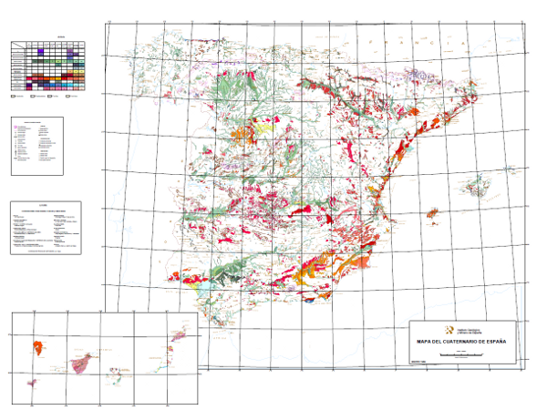
Quaternary map of Spain at a scale of 1:1,000,000
This 1:1,000,000 scale map shows the Plio-Pleistocene to contemporary deposits classified in 10 geochronological intervals and separated according to their genesis. It also includes glacial, volcanic, karstic, aeolian, coastal, edaphic, palaeontological and prehistoric phenomena.
It has been carried out by the Geological Survey of Spain (then called the GeoMining Technological Institute of Spain) with the collaboration of experts mainly from the academic world and public research centres.
It covers the entire national territory, including the archipelagos, with the exception of Melilla.
Simple
- Alternate title
-
Quaternary1000
- Date (Creation)
- 1988-01-01
- Date (Publication)
- 1989-01-01
- Edition
-
1ª Edición
- Edition date
- 1989-01-01
- Citation identifier
-
61120
Identification of the Geological Survey of Spain. Documentation Centre 1979-01-01
- Presentation form
- Hardcopy map
- Presentation form
- Digital map
- Purpose
-
The purpose of this map is twofold. On the one hand, to respond to the needs of scientists and planners who require information on aspects of the most recent geology. On the other hand, to reveal and facilitate a national vision of the knowledge of the Quaternary in Spain, a system that is insufficiently known.
- Credit
-
Instituto Geológico y Minero de España (Geological Survey of Spain): Organisation that has financed the production and publication of the Map.
Coordinators: Alfredo Pérez-González, Pilar Cabra Gil and Ángel Martín-Serrano.
- Status
- Completed
- Point of contact
-
Organisation name Individual name Electronic mail address Role Instituto Geológico y Minero de España (IGME-CSIC)
Alejandro Robador Moreno
Point of contact
- Maintenance and update frequency
- Not planned
-
IGME Thesaurus
-
-
General geology.geology
-
Stratigraphy Systematics
-
Quaternary
-
Holocene
-
Pleistocene
-
Quaternary Geomorphology and Geology.surface formation
-
Systematics of sedimentary rocks.sediment
-
Systematics of igneous rocks.volcanic rock
-
Systematics of sedimentary rocks.clastic sediment.glacial deposition
-
Sedimentology and sedimentary petrology.fluvial deposition
-
Marine geology.seabed
-
Geomorphology and Quaternary Geology.soil
-
Palaeontology
-
Stratigraphy.prehistory
-
- Keywords
-
-
Spain
-
-
GEMET
-
-
NATURAL ENVIRONMENT, ANTHROPIC ENVIRONMENT
-
LITHOSPHERE (soil, geological processes)
-
lithosphere
-
rocks
-
TERRITORY (landscape, geography)
-
land
-
relief form
-
- Keywords
-
-
Fluvial-glacial deposit
-
- Keywords
-
-
Glacio-lacustrine deposit
-
- Keywords
-
-
Lake deposit
-
- Keywords
-
-
Peat bog deposit
-
- Keywords
-
-
Colluvial deposit
-
- Keywords
-
-
Aeolian sediment
-
- Keywords
-
-
Glacis deposit
-
- Keywords
-
-
Tobas
-
- Keywords
-
-
EGDI
-
- Specific usage
-
It is a national map, at a scale of 1:1,000,000, so its use is limited by scale, i.e. it is a map to be used for national planning as an approximation for regional studies related to recent and current geological dynamics, research and territorial planning.
- User contact info
-
Organisation name Individual name Electronic mail address Role Instituto Geológico y Minero de España (IGME-CSIC)
Point of contact
- Access constraints
- Other restrictions
- Other constraints
- No limitations on public access.
- Use constraints
- Other restrictions
- Other constraints
-
LICENCE OF USE: Conditions of public use and dissemination of information for the re-use of IGME data. http://www.igme.es/Ayuda/CondiUso.htm
- Title
-
Geological Map of the Iberian Peninsula, Balearic Islands and Canary Islands at a scale of 1:1,000,000
- Date (Publication)
- 1995-01-01
- Cited responsible party
-
Organisation name Individual name Electronic mail address Role Instituto Geológico y Minero de España (IGME-CSIC)
Point of contact
- Aggregate Datasetindentifier
- 26047
- Association Type
- Cross reference
- Spatial representation type
- Vector
- Denominator
- 1000000
- Language
- Spanish; Castilian
- Character set
- UTF8
- Topic category
-
- Geoscientific information
- Society
))
- Extent type code
- Yes
- Geographic identifier
- ES
- Supplemental Information
-
Explanatory report in paper format.
Map and report can be consulted at the IGME Library and Documentation Centre.
- Unique resource identifier
- EPSG:23030 (ED50 / UTM zone 30N)
- Title
-
European Petroleum Surgey Group
- Date (Creation)
- 1986-01-01
Citation identifier
Cited responsible party
- Unique resource identifier
- EPSG:4728)
- Unique resource identifier
- EPSG:4258 (ETRS89 coordenadas geográficas)
- Distribution format
-
Name Version Mapa digital: SHP - ArcView ShapeFile
Unknown
Mapa digital: PDF - Portable Document Format
Unknown
Mapa digital: ARCC - Coverage of Arc-Info
Unknown
Mapa digital: ARCE - ARC/INFO Export format
Unknown
Mapa en papel
Unknown
Servicio web: WMS - Web Map Service
1.3.0
Distributor
- Distributor contact
-
Organisation name Individual name Electronic mail address Role Instituto Geológico y Minero de España (IGME-CSIC)
Distributor
- Fees
-
60 euros. En la página http://www.igme.es/internet/servicios/S30C-109061610100.pdf se encuentra la Resolución de precios públicos del IGME en la que indican ciertos tipos de descuentos .
- Distributor format
-
Name Version Mapa digital: SHP - ArcView ShapeFile
-
Mapa digital: PDF - Portable Document Format
-
Mapa digital: ARCC - Coverage of Arc-Info
-
Mapa digital: ARCE - ARC/INFO Export format
-
Distributor
- Distributor contact
-
Organisation name Individual name Electronic mail address Role Instituto Geológico y Minero de España (IGME-CSIC)
Distributor
- Distributor format
-
Name Version Mapa en papel
-
Distributor
- Distributor contact
-
Organisation name Individual name Electronic mail address Role Vicedirección Técnica de Sistemas de Información Geológica del Instituto Geológico y Minero del España (IGME-CSIC)
Distributor
- Distributor format
-
Name Version Servicio web: WMS - Web Map Service
1.3.0
- Units of distribution
-
No aplica
- OnLine resource
-
Protocol Linkage Name OGC:WMS-1.3.0-http-get-capabilities
http://mapas.igme.es/gis/services/Cartografia_Tematica/IGME_Cuaternario_1M/MapServer/WMSServer?service=wms&request=getcapabilities&SERVICE=WMS Link to the GetCapabilities of the web service hosting the product
WWW:LINK-1.0-http--related
https://mapas.igme.es/Servicios/default.aspx#IGME_MapaCuaternario_1M Link to the product page on the IGME website
- Name
- CDROM
- Hierarchy level
- Series
Completeness commission
- Name of measure
-
Phenomena that do not exist in the original cartography but do exist in the digital product.
- Measure description
-
Visual spot check and cross-checking of spatial information with attribute tables.
Conformance result
- Title
-
Visual spot check and cross-checking of spatial information with attribute tables
- Date (Revision)
- 1989-01-01
Citation identifier
- Explanation
-
Digital comparative validation and visual comparative check of the original map and the digitised map. Validation with error rate < 1%.
- Pass
- Yes
Completeness commission
- Name of measure
-
Duplicate phenomena.
- Measure description
-
Geometric and topological control using the tools of the GIS application.
Conformance result
- Title
-
Geometric and topological control using the tools of the GIS application.
- Date (Revision)
- 1989-01-01
Citation identifier
- Explanation
-
Error rate 0 %
- Pass
- Yes
Completeness omission
- Name of measure
-
Lack of phenomena
- Measure description
-
Visual spot check and cross-checking of spatial information with attribute tables.
Conformance result
- Title
-
Visual spot check and cross-checking of spatial information with attribute tables
- Date (Revision)
- 1989-01-01
Citation identifier
- Explanation
-
Digital comparative validation and visual comparative check of the original map and the digitised map. Validation with error rate < 1%.
- Pass
- Yes
Conceptual consistency
- Name of measure
-
Degree of approximation of the digital data with the conceptual model. Distribution of phenomena in classes.
- Measure description
-
Manual verification
Conformance result
- Title
-
MAGNA geological mapping data model in digital format.
- Date (Revision)
- 2012-02-01
Citation identifier
- Explanation
-
Check that the digital information is consistent with the standards that conceptually define it. Consult the standard
- Pass
- Yes
Conceptual consistency
- Name of measure
-
Degree of approximation of the digital data with the conceptual model. Properties of the phenomena
- Measure description
-
Automatic verification
Conformance result
- Title
-
MAGNA geological mapping data model in digital format.
- Date (Revision)
- 2012-02-01
Citation identifier
- Explanation
-
Check that the digital information is consistent with the standards that conceptually define it. Consult the standard
- Pass
- Yes
Format consistency
- Name of measure
-
Degree of approximation of the data to the established physical structure.
- Measure description
-
Automatic verification
Conformance result
- Title
-
Specifications for the digitisation of MAGNA geological mapping.
- Date (Revision)
- 2012-02-01
Citation identifier
- Explanation
-
Check that the digital information is in accordance with the standards. Consult the standard
- Pass
- Yes
Topological consistency
- Name of measure
-
Degree of conformity of the data to the defined topological rules. Absence of geological contacts with any of their ends (nodes) not connected to another node of other contacts, a fault or a conventional boundary.
- Measure description
-
Automatic verification
Conformance result
- Title
-
INSPIRE Data Specifications - Base Models - Generic Network Model
- Date (Publication)
- 2012-02-01
Citation identifier
- Explanation
-
Check that the digital information is in accordance with the standards. Consult the standard
- Pass
- No
Topological consistency
- Name of measure
-
Degree of conformity of the data to the defined topological rules. Correctness in the sense of registration of linear phenomena with real or conventional orientation.
- Measure description
-
Manual verification
Conformance result
- Title
-
INSPIRE Data Specifications - Base Models - Generic Network Model
- Date (Publication)
- 2012-02-01
Citation identifier
- Explanation
-
Check that the digital information is in accordance with the standards. Consult the standard
- Pass
- No
Absolute external positional accuracy
- Name of measure
-
External absolute accuracy
- Measure description
-
Mean square error in the registration of the map to be digitised.
Conformance result
- Title
-
Mean square error in the map registration to digitise
- Date (Revision)
- 1989-01-01
Citation identifier
- Explanation
-
Verification that the positional error is smaller than required by the scale of the map < 1500 m
- Pass
- Yes
Thematic classification correctness
- Name of measure
-
Absence of errors in the assignment of classes to phenomena.
- Measure description
-
Comparative study with original map. Random sampling
Conformance result
- Title
-
Data model of the MAGNA geological mapping in digital format. Specifications for the digitisation of MAGNA geological mapping.
- Date (Revision)
- 2012-02-01
Citation identifier
- Explanation
-
Digital comparative validation and visual comparative check of the original map and the digitised map. Validation with error rate < 1%.
- Pass
- Yes
Thematic classification correctness
- Name of measure
-
Absence of errors in the assignment of identifiers to cartographic units.
- Measure description
-
Comparative study with original map
Conformance result
- Title
-
Comparative study with original map
- Date (Revision)
- 1989-01-01
Citation identifier
- Explanation
-
Digital comparative validation and comparative visual check of the original map and the digitised map. Error rate 1%. Error area < 0.1% in cartographic units.
- Pass
- Yes
Non quantitative attribute accuracy
- Name of measure
-
Accuracy of non-quantitative attributes: absence of errors in the assignment of values.
- Measure description
-
Comparative study with original map.
Conformance result
- Title
-
Comparative study with original map
- Date (Revision)
- 1989-01-01
Citation identifier
- Explanation
-
Digital comparative validation and comparative visual check of the original map and the digitised map. Error rate 1%. Error area < 0.1% in cartographic units.
- Pass
- Yes
Quantitative attribute accuracy
- Name of measure
-
Accuracy of quantitative attributes: absence of errors in the assignment of values.
- Measure description
-
Comparative study with original map
Conformance result
- Title
-
Comparative study with original map
- Date (Revision)
- 1989-01-01
Citation identifier
- Explanation
-
Digital check of digital information. Error rate 1%. Error area < 0.1% in cartographic units.
- Pass
- Yes
Conformance result
- Date (Publication)
- 2010-12-08
Citation identifier
- Explanation
-
See regulations
- Pass
- No
Conformance result
Conformance result
- Statement
-
The map was drawn up from the compilation of cartographic information at scales 1:25,000, 1:50,000 and 1:200,000 produced by the IGME, unpublished cartography, Doctoral Theses, Dissertations and other published works.
Subsequently, the phenomena to be included in the cartography were established and the legend of surface formations was drawn up. Next, the processes of synthesis, reclassification, generalisation and exaggeration were carried out for the final production of the map.
The digitisation process was carried out in 1991 from the printing plates and the definitive normalisation and generation of symbolised files (.lyr) and cartography, in version 8.3 of ArcGis, in 2003.
- Description
-
Compilation of existing information:
Bibliographic information.
Topographical base.
Geological and related maps at various scales.
Palaeontological and prehistoric information.
- Description
-
Preparation of the map:
Elaboration of the legend of surface formations.
Plotting of surface formations.
Establishment and plotting of geomorphological, palaeontological and prehistoric phenomena to be included in the map.
- Description
-
Digitisation:
Inventory, selection and coding of the phenomena to be included in the digital mapping.
Digitisation in accordance with the Institute's specifications.
Geometric processing.
Association of attributes to spatial objects and creation of tables.
Checking of digital information, detection and correction of errors.
Verification of the consistency between the different digital maps.
- Description
-
The rock units of the sheet separated by different types of contacts are represented, together with the tectonic structure, faults and map traces of folds, the orientation and dip of planar and linear elements contained in the rocks, structural and textural singularities of igneous and metamorphic rocks, water points, mineral deposits and indications, presence of fossils and other elements of punctual representation.
- Denominator
- 50000
- Title
-
Geological Map of Spain scale 1:50.000 MAGNA
- Date (Creation)
- 1971-01-01
- Cited responsible party
-
Organisation name Individual name Electronic mail address Role Instituto Geológico y Minero de España (IGME-CSIC)
Martín-Serrano García, Ángel
Originator Instituto Geológico y Minero de España (IGME-CSIC)
Robador Moreno, Alejandro
Distributor
- Presentation form
- Hardcopy document
- Description
-
The rock units of the sheet separated by different types of contacts are represented, together with the tectonic structure, faults and map traces of folds, the orientation and dip of planar and linear elements contained in the rocks, structural and textural singularities of igneous and metamorphic rocks, water points, mineral deposits and indications, presence of fossils and other elements of punctual representation.l
- Denominator
- 200000
- Title
-
Geological Map of Spain scale 1:200,000
- Date (Creation)
- 1981-01-01
- Cited responsible party
-
Organisation name Individual name Electronic mail address Role Instituto Geológico y Minero de España (IGME-CSIC)
Martín-Serrano García, Ángel
Originator Instituto Geológico y Minero de España (IGME-CSIC)
Martín-Serrano García, Ángel
Distributor
- Presentation form
- Hardcopy map
- Presentation form
- Hardcopy document
Metadata
- File identifier
- ESPIGMECUATERNARIO10002010080661120 XML
- Metadata language
- Spanish; Castilian
- Character set
- UTF8
- Hierarchy level
- Dataset
- Date stamp
- 2025-05-09T07:15:48.699105Z
- Metadata standard name
-
Reglamento (CE) Nº 1205/2008 de Inspire, "Perfil IGME"
- Metadata standard version
-
2.0
- Metadata author
-
Organisation name Individual name Electronic mail address Role Instituto Geológico y Minero de España (IGME-CSIC)
Leticia Vega Martín
Point of contact
- Other language
-
Language Character encoding English UTF8 Spanish; Castilian UTF8
)))