 Catalogo de metadatos IGME-CSIC
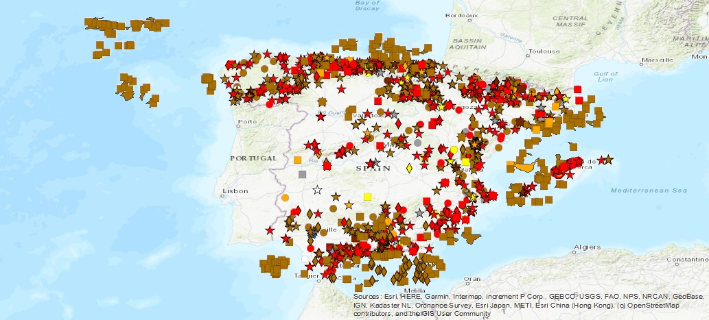
Base de Datos de Movimientos del terreno (BDMOVES)
Terrain Movements Database (BDMOVES)
Inventario nacional español de movimientos del terreno. Incluye movimientos del terreno de origen geológico gravitacional que afectan a territorio español tales como movimientos de ladera (landslides): deslizamientos, desprendimientos, flujos, etc., movimientos verticales: subsidencias, colapsos, expansividad y deslizamientos submarinos No incluye movimientos de origen tectónico como los producidos por terremotos o deriva continental o de origen volcánico. BD-MOVES se estructura en dos bloques o conjuntos de información espacial georeferenciada: la referida a la descripción de las características propias intrínsecas y relativamente invariables del movimiento del terreno y la referida a los diferentes eventos de actividad que produjeron dichos movimientos, incluyendo morfometría, factores desencadenantes y daños, entre otros datos.
Spanish national inventory of land movements. Includes land movements of gravitational geological origin affecting Spanish territory, such as landslide movements: landslides, landslides, flows, etc., vertical movements: subsidies, collapses, expansiveness and underwater landslides. It does not include movements of tectonic origin such as those produced by earthquakes or continental drift or of volcanic origin. BD-MOVES is structured in two blocks or sets of georeferenced spatial information: the one referring to the description of the intrinsic and relatively invariable characteristics of the movement of the terrain and the one referring to the different activity events that produced these movements, including morphometry, triggering factors and damages, among other data.
Simple
-
Título alternativoAlternate title
-
BDMOVES
BDMOVES
-
Date (Creation)Fecha (Creación)
- 2015-12-01
-
Date (Publication)Fecha (Publicación)
- 2016-12-01
- Unique resource identifier
- ESPIGMEBDMOVES
- Codespace
-
IGME-CSIC
-
PropósitoPurpose
-
Base de datos de los movimientos del terreno (deslizamientos, subsidencias y colapsos) que han sido inventariados por el IGME
Terrain Movements Database (landslides, subsidies and collapses) that have been inventoried by the IGME
-
Crédito
-
Juan Carlos García López-Davalillo
- Point of contact
-
Organisation name Individual name Electronic mail address Role Instituto Geológico y Minero de España (IGME-CSIC)Geological Survey of Spain (IGME-CSIC)Juan Carlos García Lopez-Davalillo
Point of contactPunto de Contacto
-
Maintenance and update frequencyMantenimiento y frecuencia de actualización
-
Not plannedSin planificar
- Keywords
-
-
IGME
IGME
-
Movimientos del terreno
Ground Movements
-
Subsidiencia
Subsidence
-
Riesgos geológicos
Geohazards
-
-
Tesauro IGME
IGME Thesaurus
-
-
Deslizamiento
Landslide
-
Inventario
Inventory
-
España
Spain
-
-
Uso específicoSpecific usage
-
BDMoves es una herramienta necesaria para el conocimiento tanto de los movimientos del terreno de origen geológico gravitacional que afectan al territorio español: movimientos de ladera (landslides): deslizamientos, desprendimientos, flujos, etc., movimientos verticales: subsidencias, colapsos, expansividad y deslizamientos submarinos; como los diferentes eventos de actividad que produjeron dichos movimientos, incluyendo morfometría, factores desencadenantes y daños, entre otros datos. Sin incluir movimientos de origen tectónico (terremotos o deriva continental o de origen volcánico).
BDMoves is a necessary tool for the knowledge of both the movements of the land of gravitational geological origin that affect the Spanish territory: landslide movements: landslides, landslides, flows, etc., vertical movements: subsidies, collapses, expansiveness and underwater landslides; and the different activity events that produced these movements, including morphometry, triggering factors and damage, among other data. Not including movements of tectonic origin (earthquakes or continental drift or volcanic origin).
- User contact info
-
Organisation name Individual name Electronic mail address Role Instituto Geológico y Minero de España (IGME-CSIC)Geological Survey of Spain (IGME-CSIC)Point of contactPunto de Contacto
-
Access constraintsRestricciones de Acceso
-
Other restrictionsOtras restricciones
-
Otras limitacionesOther constraints
-
Sin limitaciones al acceso públicoNo limitations on public access
-
Use constraintsRestricciones de uso
-
Other restrictionsOtras restricciones
-
Otras limitacionesOther constraints
-
LICENCIA DE USO: Condiciones de uso público y difusión de la información para la reutilización de los datos IGME. https://www.igme.es/condiciones-de-uso/
LICENSE OF USE: Conditions of public use and dissemination of information for the reuse of data. https://www.igme.es/condiciones-de-uso/
-
Otras limitacionesOther constraints
-
Propiedad intelectual
Intellectual property
-
Spatial representation typeTipo de representación espacial
-
VectorVector
-
DenominatorDenominador
- 50000
-
DenominatorDenominador
- 25000
-
LanguageIdioma
- Spanish; Castilian
-
Character setCodificación
-
UTF8UTF8
-
Topic categoryCategoría temática
-
-
Geoscientific informationInformación geocientífica
-
))
-
Extent type codeCódigo del tipo de extensión
- Yes
-
Geographic identifierIdentificador geográfico
-
ESES
-
Identificador único del recursoUnique resource identifier
-
EPSG:4326EPSG:4326
-
Identificador único del recursoUnique resource identifier
-
EPSG:4258 (ETRS89 coordenadas geográficas)EPSG:4258 (ETRS89 coordenadas geográficas)
-
Identificador único del recursoUnique resource identifier
-
EPGS:4230EPGS:4230
-
Identificador único del recursoUnique resource identifier
-
EPSG:23028 (ED50 / UTM zone 28Pico de las Nieves)EPSG:23028 (ED50 / UTM zone 28Pico de las Nieves)
-
Identificador único del recursoUnique resource identifier
-
EPSG:23029 (ED50 / UTM zone 29N)EPSG:23029 (ED50 / UTM zone 29N)
-
Identificador único del recursoUnique resource identifier
-
EPSG:23030 (ED50 / UTM zone 30N)EPSG:23030 (ED50 / UTM zone 30N)
-
Identificador único del recursoUnique resource identifier
-
EPGS:23031 (ED50 / UTM zone 31N)EPGS:23031 (ED50 / UTM zone 31N)
-
Identificador único del recursoUnique resource identifier
-
EPSG:25828EPSG:25828
-
Identificador único del recursoUnique resource identifier
-
EPSG:25829EPSG:25829
-
Identificador único del recursoUnique resource identifier
-
EPSG:25830EPSG:25830
-
Identificador único del recursoUnique resource identifier
-
EPSG:25831EPSG:25831
-
Identificador único del recursoUnique resource identifier
-
EPSG:3857EPSG:3857
-
Identificador único del recursoUnique resource identifier
-
EPSG:102100EPSG:102100
- Distribution format
-
Name Version SHP (uso restringido)
No se aplica
Web Map Service WMS
1.3.0
Distributor
Distribuidor
- Distributor contact
-
Organisation name Individual name Electronic mail address Role Instituto Geológico y Minero de España (IGME-CSIC)Geological Survey of Spain (IGME-CSIC)DistributorDistribuidor
- Fees
-
Distribución a través de la web
- Distributor format
-
Name Version Joint Photographic Group Format JPEG
Joint Photographic Group Format JPEG
No se aplica
Web Map Service WMS
Web Map Service WMS
1.3.0
Distributor
Distribuidor
- Distributor contact
-
Organisation name Individual name Electronic mail address Role Área de Sistemas de Información Geológica del Instituto Geológico y Minero del España (IGME-CSIC)
Geological Information Systems Area of the Geological Survey of Spain (IGME-CSIC)
DistributorDistribuidor
- Distributor format
-
Name Version Servicio web: WMS - Web Map Service
Servicio web: WMS - Web Map Service
1.3.0
- OnLine resource
-
Protocol Linkage Name Servicio de visualización WMS de la Base de Datos de Movimientos del terreno (BDMOVES)
http://mapas.igme.es/gis/services/BasesDatos/IGME_BDMoves_ES/MapServer/WMSServer?REQUEST=GetCapabilities&SERVICE=WMS WWW:LINK-1.0-http--link
http://info.igme.es/BD2DMoves/ Descarga de la Base de Datos de Movimientos del terreno (BDMOVES)
Download Terrain Movement Database (BDMOVES)
-
Hierarchy levelJerarquía
-
DatasetConjunto de datos
Conformance result
Conformidad del Resultado
-
Date (Publication)Fecha (Publicación)
- 2009-10-19
-
ExplicaciónExplanation
-
ConformeConformant
-
PassAprobado
- Yes
Conformance result
Conformidad del Resultado
-
Date (Publication)Fecha (Publicación)
- 2014-12-31
-
ExplicaciónExplanation
-
Los datos no son conformesNot Conformant
-
PassAprobado
- No
Conformance result
Conformidad del Resultado
-
TítuloTitle
-
Reglamento (CE) No 1205/2008 de la Comisión de 3 de Diciembre de 2008 que estabelece las modalidades de aplicación de la Directiva 2007/2/CE del Parlamento Europeo y del Consejo em materia de metadados
Commission Regulation (EC) No 1205/2008 of 3 December 2008 laying down detailed rules for the implementation of Directive 2007/2/EC of the European Parliament and of the Council as regards metadata
-
Date (Publication)Fecha (Publicación)
- 2008-12-04
-
ExplicaciónExplanation
-
Consultar el reglamento
Consult the regulations
-
PassAprobado
- Yes
-
DeclaraciónStatement
-
BD-MOVES se estructura en dos bloques o conjuntos de información espacial georeferenciada: la referida a la descripción de las características propias intrínsecas y relativamente invariables del movimiento del terreno y la referida a los diferentes eventos de actividad que produjeron dichos movimientos, incluyendo morfometría, factores desencadenantes y daños, entre otros datos.
BD-MOVES is structured in two blocks or sets of georeferenced spatial information: the one referring to the description of the intrinsic and relatively invariable characteristics of the movement of the terrain and the one referring to the different activity events that produced such movements, including morphometry, triggering factors and damages, among other data.
Metadata
-
File identifierIdentificador del fichero
- ESPIGMEBDMOVES20190723 XML
-
Metadata languageIdioma del metadato
- Spanish; Castilian
-
Character setCodificación
-
UTF8UTF8
-
Hierarchy levelJerarquía
-
DatasetConjunto de datos
-
Date stampFecha
- 2026-03-24T12:58:25.267864Z
- Metadata standard name
-
Reglamento (CE) Nº 1205/2008 de Inspire, "Perfil IGME"
- Metadata standard version
-
2.0
- Metadata author
-
Organisation name Individual name Electronic mail address Role Instituto Geológico y Minero de España (IGME-CSIC)Geological Survey of Spain (IGME-CSIC)Leticia Vega Martín
Point of contactPunto de Contacto
- Other language
-
Language Character encoding EnglishEnglishUTF8UTF8Spanish; CastilianSpanish; CastilianUTF8UTF8
)))