 Catalogo de metadatos IGME-CSIC
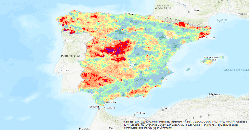
Holmium isocontent map (Geochemical Atlas of Spain, 2012)
Iso-content maps of Holmium (Ho), one of the chemical elements.obtained in the Geochemical Atlas of Spain Project, distributed in stream sediments (14,864 samples), superficial soils (0-20 cm.) (13,505 samples) and deeper soils (20-40 cm.) (7,682 samples). The results of the chemical analysis are shown in two types: total dissolution of the sample with 4 acids and partial dissolution with aqua regia. With the analytical results of all the sampled points, an isocontent map is made with adjustment to a square grid of 1,000 m by the method of interpolation of the inverse of the squared distance. The final result is a map for each type of sample and type of analysis carried out.
Simple
- Alternate title
-
Holmium Isovalues (Geochemical Atlas)
- Date (Creation)
- 2012-01-01
- Date (Publication)
- 2012-01-01
- Citation identifier
- ESPIGMEATLASGEOQUIMICAHO
- Presentation form
- Hardcopy map
- Presentation form
- Digital map
- Purpose
-
The main objective of this project, co-financed with funds from the European Economic Area (EEA), has been to develop a geochemical knowledge base of the surface materials (stream sediments and soils) of the national territory, both continental and insular, which will allow us to tackle with the necessary information the problems that, for both ecosystems and public health, derive from soil contamination and those related to the geology and mineral resources of Spain.
- Credit
-
Locutura, J., Bel-lan Ballester, A., García-Cortés, A., Martínez Romero, S.
- Status
- Completed
- Point of contact
-
Organisation name Individual name Electronic mail address Role Instituto Geológico y Minero de España (IGME-CSIC)
Iván Martín Méndez
Distributor Instituto Geológico y Minero de España (IGME-CSIC)
Margarita Sanabria Pavón
Processor Instituto Geológico y Minero de España (IGME-CSIC)
Distributor
- Maintenance and update frequency
- Unknown
- Maintenance note
-
The updating of the data is carried out at the request of the person in charge of the IGME assigned to this area. Depending on the magnitude of the modifications, there are different editing protocols for the alteration of the current data.
-
IGME Thesaurus
-
-
Geochemistry
-
Holmium
-
Analysis
-
Soils
-
Sediments
-
Elements
-
Quality control
-
Geochemical monitoring
-
Metallogeny
-
Atlas
-
Geochemical map
-
Sampling
-
Minerals
-
Metal
-
Mineral Resources
-
Ecosystems
-
Spain
-
- Keywords
-
-
Sample
-
Heatlh
-
IGCP 259
-
- Keywords
-
-
EGDI
-
- Keywords
-
-
EGDI-selection
-
- Discipline
-
-
Geology
-
Geochemistry
-
Mining
-
- Specific usage
-
Geology, Geochemistry, Mineralogical Cartography, Cartographic edition, Research of natural resources, Environment, etc.
- User contact info
-
Organisation name Individual name Electronic mail address Role Instituto Geológico y Minero de España (IGME-CSIC)
Point of contact
- Access constraints
- Other restrictions
- Other constraints
- No Limitations
- Use constraints
- Other restrictions
- Other constraints
-
LICENCE OF USE: Conditions of public use and dissemination of information for the re-use of IGME data. https://www.igme.es/condiciones-de-uso/
- Spatial representation type
- Grid
- Distance
- 1000 m
- Language
- Spanish; Castilian
- Character set
- UTF8
- Topic category
-
- Geoscientific information
- Description
-
Spain
))
- Extent type code
- Yes
- Geographic identifier
- ES
- Unique resource identifier
- EPSG:4326
- Unique resource identifier
- EPSG:4258
- Unique resource identifier
- EPSG:23028 (ED50 / UTM zone 28Pico de las Nieves)
- Unique resource identifier
- EPSG:23029 (ED50 / UTM zone 29N)
- Unique resource identifier
- EPSG:23030 (ED50 / UTM zone 30N)
- Unique resource identifier
- EPGS:23031 (ED50 / UTM zone 31N)
- Unique resource identifier
- EPGS:23031 (ED50 / UTM zone 31N)
- Unique resource identifier
- EPSG:4230
- Unique resource identifier
- EPGS:25828
- Unique resource identifier
- EPGS:25829
- Unique resource identifier
- EPGS:25830
- Unique resource identifier
- EPGS:25831
- Unique resource identifier
- EPGS:3857
- Unique resource identifier
- EPGS:102100
- Distribution format
-
Name Version ASCII-GRID Unknown
RASTER: JPG Con fichero de georeferenciación
Unknown
Mapa digital: JPG - Joint Photographic Experts Group
Unknown
Mapa digital: TIFF - Tagged Image File Format
Unknown
Mapa digital: BMP - Bits Maps Protocole
Unknown
Mapa digital: PNG - Portable Network Graphics
Unknown
Mapa Digital: KML - Keyhole Markup Language
Unknown
Distributor
- Distributor contact
-
Organisation name Individual name Electronic mail address Role Instituto Geológico y Minero de España (IGME-CSIC)
Distributor
- Fees
-
Acceso a servicios de mapas desde INFOIGME: Portal de Cartografía Geocientífica Digital
- Fees
-
Distribución a través de la web gratuita
- Distributor format
-
Name Version Joint Photographic Group Format JPEG
Arcgis 10.7
Web Service: WMS - Web Map Service
1.3.0
Distributor
- Distributor contact
-
Organisation name Individual name Electronic mail address Role Sistemas de Información Geológica. Instituto Geológico y Minero de España (IGME-CSIC)
Distributor
- Distributor format
-
Name Version Web Service: WMS
1.3.0
- OnLine resource
-
Protocol Linkage Name https://mapas.igme.es/gis/services/AtlasGeoquimico/IGME_MapaIsovalores2012_Ho/MapServer/WMSServer?service=wms&request=getcapabilities&version=1.3.0 WMS visualization service of the Geochemical Map of Holmium isovalues (Ho)
GLG:KML-2.0-http-get-map
https://mapas.igme.es/gis/rest/services/AtlasGeoquimico/IGME_MapaIsovalores2012_Ho/MapServer/kml/mapImage.kmz Google Earth service (KML)
WWW:LINK-1.0-http--link
https://mapas.igme.es/gis/rest/services/AtlasGeoquimico/IGME_MapaIsovalores2012_Ho/MapServer ArcGIS Server Service for Holmium Isovalues (Atlas of Geochemistry, 2012)
https://www.igme.es/actividadesIGME/lineas/CartoGeo/geoquimica/geoquimicaEsp.htm Information from the Geochemistry Atlas of Spain (2012) through the IGME website
- Hierarchy level
- Dataset
Conformance result
Conformance result
- Statement
-
Isocontent maps of the chemical elements obtained in the Geochemical Atlas of Spain Project, distributed in stream sediments (14,864 samples), shallow soils (0-20 cm) (13,505 samples) and deeper soils (20-40 cm) (7,682 samples). The results of the chemical analysis are shown in two types: total dissolution of the sample with 4 acids and partial dissolution with aqua regia. With the analytical results of all the sampled points, an isocontent map is made with adjustment to a square grid of 1,000 m by the method of interpolation of the inverse of the squared distance. The final result is a map for each type of sample and type of analysis carried out.
- Description
-
Generation of the original data set
- Description
-
Uniform processing of the data set
- Description
-
BDD Integration
- Description
-
Publicacion en internet
Metadata
- File identifier
- ESPIGMEATLASGEOQUIMICAHO20210607 XML
- Metadata language
- Spanish; Castilian
- Character set
- UTF8
- Hierarchy level
- Dataset
- Date stamp
- 2025-05-09T07:16:31.343478Z
- Metadata standard name
-
Reglamento (CE) Nº 1205/2008 de Inspire, "Perfil IGME"
- Metadata standard version
-
TG 2.0
- Metadata author
-
Organisation name Individual name Electronic mail address Role Instituto Geológico y Minero de España (IGME-CSIC)
Leticia Vega Martín
Point of contact
- Other language
-
Language Character encoding English UTF8 Spanish; Castilian UTF8
)))