 Catalogo de metadatos IGME-CSIC
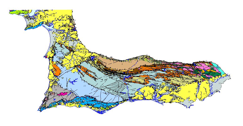
Service of visualization (WMS) of the Geological Map of the South Portughese Zone . Scale 1/400.000. 2020 edition
Geological map of the South Portuguese Zone, at a scale of 1/400,000, in which the geological legend on both sides of the border has been harmonized, with unified criteria between Spain and Portugal. This cartography is a product resulting from the GEO_FPI project: GEO_FPI: cross-border observatory for the geo-economic evaluation of the Iberian Pyrite Belt, financed by the European Regional Development Fund (ERDF) within the program INTERREG V-A Spain– Portugal (POCTEP) 2014-2020. The main beneficiary of the project is the Geological Survey of Spain (IGME-CSIC) . Additionally, the General Directorate of Industry, Energy and Mines of the Ministry of Employment, Enterprise and Commerce of the Andalusian Government (JA) and the Portuguese National Laboratory for Energy and Geology (LNEG) and the Municipal Chamber of Aljustrel (CMA) are partners of the project.
Simple
Identification info
- Date (Creation)
- 2019-07-01
- Point of contact
-
Organisation name Individual name Electronic mail address Role Geological Survey of Spain (IGME-CSIC)
Point of contact Geological Survey of Spain (IGME-CSIC)
Custodian
-
Thesaurus IGME
-
-
Alentejo
-
Algarve
-
Andalusia
-
Cartography
-
Geology
-
Chronostratigraphy
-
Spain
-
Portugal
-
- Keywords
-
-
400K
-
- Keywords
-
-
Iberian Pyritic Belt Cinturão Pyritic Ibérico.
-
- Keywords
-
-
Surportuguese zone
-
- Keywords
-
-
IGME
-
- Keywords
-
-
LNEG
-
- Keywords
-
-
EGDI
-
- Keywords
-
-
WMS
-
-
Web Services Specifications
-
-
OGC (Open Geospatial Consortium)
-
WMS (Web Map Service)
-
WMS 1.3.0
-
OGC
-
WMS
-
-
ISO - 19119 geographic services taxonomy
-
-
infoMapAccessService
-
-
INSPIRE_SpatialDataServicesClassification
-
-
Map access service
-
Geographic modelling/information management service
-
- Access constraints
- Other restrictions
- Other constraints
- No limitations on public access
- Use constraints
- Other restrictions
- Other constraints
-
LICENCE OF USE: Conditions of public use and dissemination of information for the re-use of IGME data http://www.igme.es/Ayuda/CondiUso.htm
- Service Type
- view
))
- Coupling Type
- Tight
- Contains Operations
-
Operation Name Distributed Computing Platforms Connect Point GetCapabilities
Web services http://mapas.igme.es/gis/services/GeoFPI/GEOFPI_GEOLOGICO400/MapServer/WMSServer GetMap
Web services http://mapas.igme.es/gis/services/GeoFPI/GEOFPI_GEOLOGICO400/MapServer/WMSServer GetFeatureInfo
Web services http://mapas.igme.es/gis/services/GeoFPI/GEOFPI_GEOLOGICO400/MapServer/WMSServer
- Unique resource identifier
- EPSG:3857
- Unique resource identifier
- CRS:84
- Unique resource identifier
- EPSG:4258
- Unique resource identifier
- EPSG:4326
- Unique resource identifier
- EPSG:4230
- Unique resource identifier
- EPSG:23028
- Unique resource identifier
- EPSG:23029
- Unique resource identifier
- EPSG:23030
- Unique resource identifier
- EPSG:23031
- Unique resource identifier
- EPSG:25828
- Unique resource identifier
- EPSG:25829
- Unique resource identifier
- EPSG:25830
- Unique resource identifier
- EPSG:25831
- Unique resource identifier
- EPSG:102100
- Distribution format
-
Name Version image/png
not applicable
image/jpeg
not applicable
image/tiff
not applicable
image/gif
not applicable
image/bmp
not applicable
- Distributor contact
-
Organisation name Individual name Electronic mail address Role Geological Survey of Spain (IGME-CSIC)
Distributor
- OnLine resource
-
Protocol Linkage Name OGC:WMS-1.3.0-http-get-capabilities
http://mapas.igme.es/gis/services/GeoFPI/GEOFPI_GEOLOGICO400/MapServer/WMSServer?REQUEST=GetCapabilities&SERVICE=WMS Visualisation service (WMS) of the Geological Map of the SouthPortuguese Area 1/400.000
- Hierarchy level
- Service
- Other
-
Servicio web de datos espaciales. Servicio de visualización
Conformance result
- Date (Publication)
- 2009-10-19
- Explanation
-
Consult the above-mentioned regulation
- Pass
- No
Conformance result
- Title
-
Commission Regulation (EU) No 1089/2010 of 23 November 2010 implementing Directive 2007/2/EC of the European Parliament and of the Council as regards the interoperability of spatial data sets and services
- Date (Publication)
- 2010-12-08
- Explanation
-
Consult the regulations
- Pass
- No
Conformance result
- Title
-
COMMISSION REGULATION (EC) No 1205/2008 of 3 December 2008 implementing Directive 2007/2/EC of the European Parliament and of the Council as regards metadata
- Date (Publication)
- 2008-12-04
Citation identifier
- Explanation
-
Consult the above-mentioned regulation
- Pass
- Yes
Metadata
- File identifier
- ESPIGMESERVICIOFPIGEOLOGICO40020201201 XML
- Metadata language
- Spanish; Castilian
- Character set
- UTF8
- Hierarchy level
- Service
- Hierarchy level name
-
Servicio
- Date stamp
- 2025-05-09T05:36:29.404977Z
- Metadata standard name
-
Reglamento (CE) Nº 1205/2008 de Inspire, "Perfil IGME"
- Metadata standard version
-
2.0
- Metadata author
-
Organisation name Individual name Electronic mail address Role Geological Survey of Spain (IGME-CSIC)
Leticia Vega Martín
Point of contact
- Other language
-
Language Character encoding English UTF8 Portuguese UTF8 Spanish; Castilian UTF8
)))