 Catalogo de metadatos IGME-CSIC
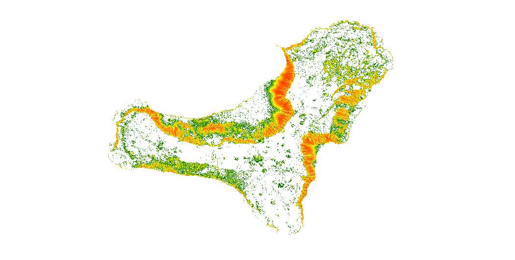
CARTOGRAPHY OF ROCKFALLS SUSCEPTIBILITY IN THE ISLAND OF EL HIERRO, CANARY ISLANDS
The map show the number of trajectories that pass through each pixel.
Simple
- Alternate title
-
MAP OF ROCKFALL TRAJECTORIES SIMULATION IN THE ISLAND OF EL HIERRO, CANARY ISLANDS
- Date (Creation)
- 2019-10-15
- Edition date
- 2019-10-15
- Citation identifier
- / ESPIGMEROCKFALLSTRAJECTORIESELHIERRO
- Presentation form
- Hardcopy map
- Presentation form
- Digital map
- Purpose
-
The data may be used as input to calculate rockfalls risk on the island of El Hierro (Canary Islands), and to estimate the potential economic losses.
- Credit
-
Roberto Sarro Trigueros:(1); Rosa María Mateos Ruiz (1),Paola Reichenbach (2), Mauro Rossi (2).. (1)- Geological Survey of Spain (IGME-CSIC); (2)-Istituto di Ricerca per la Protezione Idrogeologica (IRPI), National Research Council (CNR)
- Status
- Completed
- Point of contact
-
Organisation name Individual name Electronic mail address Role Geological Survey of Spain (IGME-CSIC)
Roberto Sarro Trigueros
Author Geological Survey of Spain (IGME-CSIC)
Rosa María Mateos Ruiz
Author Research Institute for Hydrogeological Protection, National Research Council (CNR-IRPI)
Paola Reichenbach
Author Research Institute for Hydrogeological Protection, National Research Council (CNR-IRPI)
Mauro Rossi
Author
- Maintenance and update frequency
- Not planned
- Keywords
-
-
IGME
-
Geological hazards
-
infoMapAccessService
-
-
Tesauro IGME
-
-
Rockfalls
-
Trajectory
-
Risk
-
Hazard
-
volcanic environment
-
Canary Islands
-
- Discipline
-
-
Geohazards
-
- Keywords
-
-
EGDI
-
- Specific usage
-
Rockfall risk mapping, Vulnerability, Emergency management, Urban planning
- User contact info
-
Organisation name Individual name Electronic mail address Role Geological Survey of Spain (IGME-CSIC)
Point of contact
- Access constraints
- Other restrictions
- Other constraints
- No limitations to public access.
- Use constraints
- Other restrictions
- Other constraints
-
LICENSE FOR USE: Conditions governing the public use and dissemination of the information for the re-use of the IGME data. http://www.igme.es/Ayuda/CondiUso.htm
- Use constraints
- Other restrictions
- Spatial representation type
- Grid
- Denominator
- 25000
- Denominator
- 50000
- Denominator
- 1000000
- Language
- English
- Character set
- UTF8
- Topic category
-
- Geoscientific information
))
- Extent type code
- Yes
- Geographic identifier
- ES
- Unique resource identifier
- EPSG:4258
- Unique resource identifier
- EPSG:32628
- Distribution format
-
Name Version GRID (Restricted use) Unknown
Web Map Service WMS
1.3.0
Distributor
- Distributor contact
-
Organisation name Individual name Electronic mail address Role Geological Survey of Spain (IGME-CSIC)
Distributor
- Fees
-
Distribution through the web
- Distributor format
-
Name Version Digital:Map GRID - ArcView RasterFile
Not applicable
Joint Photographic Group Format JPEG
No se aplica
Tagged Image File FormatTIFF
No se aplica
Web Map Service WMS
1.3.0
- Distributor contact
-
Organisation name Individual name Electronic mail address Role Area of Geoscientific Information Systems of the Geological and Mining Institute of Spain (IGME-CSIC)
Distributor
- OnLine resource
-
Protocol Linkage Name Visualization service of the map of rockfall trajectories simulation in the island of El Hierro, Canary Islands
http://mapas.igme.es/gis/services/UGeoHaz/UGEOHAZ_ROCKFALLTRAJECTORIES_ELHIERRO/MapServer/WMSServer?REQUEST=GetCapabilities&SERVICE=WMS WWW:LINK-1.0-http--link
http://www.igme.es Download of the map of rockfall trajectories simulation in the island of El Hierro, Canary Islands
- Hierarchy level
- Dataset
Conformance result
Conformance result
Conformance result
- Title
-
Commission Regulation (EC) No 1205/2008 of 3 December 2008 laying down detailed rules for the implementation of Directive 2007/2/EC of the European Parliament and of the Council as regards metadata
- Date (Publication)
- 2008-12-04
- Explanation
-
See the above-mentioned regulation
- Pass
- Yes
- Statement
-
This work has been developed in the framework of the U-GEOHAZ project (Geohazard Impact Assessment for Urban Areas), funded by the European Commission, Directorate-General Humanitarian Aid and Civil Protection (ECHO), Grant Agreement No. 783169.
- Description
-
Stage 1 - Collection of thematic cartographic.
- Description
-
Stage 2 - Preparation of input data in ascii format
- Description
-
Stage 3 - Simulation the trajectories using STONE code (Guzzetti et al. 2002). The software uses GIS technology to produce 2D-3D raster outputs.
- Description
-
This map represents the areas with higher rockfall susceptibility. The data was derived from terrain and geological information. The input DEM was generated by the National Geographic Institute at a 5m x 5m resolution. According to the available National Geological Continuous Map of Spain (GEODE) from IGME (www.igme.es), lithological units were differentiated and their coefficients were obtained.
- Denominator
- 50000
Metadata
- File identifier
- ESPIGMEROCKFALLSTRAJECTORIESELHIERRO20191031 XML
- Metadata language
- Spanish; Castilian
- Character set
- UTF8
- Hierarchy level
- Dataset
- Date stamp
- 2025-04-04T12:34:26.966487Z
- Metadata standard name
-
Reglamento (CE) Nº 1205/2008 de Inspire, "Perfil IGME"
- Metadata standard version
-
2.0
- Metadata author
-
Organisation name Individual name Electronic mail address Role Geological Survey of Spain (IGME-CSIC)
Leticia Vega Martín
Point of contact
- Other language
-
Language Character encoding English UTF8 Spanish; Castilian UTF8
)))