 Catalogo de metadatos IGME-CSIC
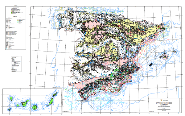
Neotectonic Map of Spain at a scale of 1:1,000,000
The Neotectonic Map expresses those structural, morphological, stratigraphic and other features that show relatively recent movements (from the period considered neotectonic), as well as the type of stress to which the peninsula is subjected. Its objectives are to identify deformations from the Middle Miocene - Upper Miocene boundary to the present day. The materials have been classified into six categories, two for volcanic materials differentiated by age; and four for the rest of the materials, with four subdivisions according to age. It also includes tectonic structures, stress and deformation directions, diapiric structures and other related phenomena, all with age expression. The map contains information on the Spanish continental shelf. This map, of national scope, has been produced by the Geological Survey of Spain in collaboration with the National Radioactive Waste Company (ENRESA).
Simple
- Alternate title
-
Neotectonic1000
- Alternate title
-
Neotectonic ITGE-ENRESA
- Date (Creation)
- 1990-12-03
- Citation identifier
- 26045
- Presentation form
- Digital map
- Presentation form
- Digital document
- Presentation form
- Hardcopy document
- Presentation form
- Digital map
- Purpose
-
The Iberian Peninsula is an active geodynamic region with a recognised medium seismicity, either due to the occurrence of earthquakes or due to the action of slower and less sudden tectonic processes, sometimes imperceptible to man, but which in the long run have an impact on socio-economic and environmental aspects. These dynamics can eventually translate into risk to life and substantial economic losses. This map is therefore applicable in many areas of action such as land-use plans, urban planning, emergency and civil protection plans, industrial and military installations, public works and seismic prediction programmes. Always bearing in mind that its scale orients it to national or regional projects, requiring detailed studies for larger scales.
- Credit
-
Geological Survey of Spain (IGME) and National Radioactive Waste Company(enresa): Organisations that have financed the production and edition of the map: V. Gabaldón López (IGME), A. Castañón Gómez (enresa); Authors: J. Baena Pérez, F. Moreno Serrano, F. Nozal Martín, J.A. Alfaro Zubero, L.M. Barranco Sanz
- Status
- Completed
- Point of contact
-
Organisation name Individual name Electronic mail address Role Instituto Geológico y Minero de España (IGME-CSIC)
Nozal Martín, Francisco
Point of contact
- Maintenance and update frequency
- Not planned
-
INSPIRE_SpatialThemes
-
-
Geology
-
Natural risk zones
-
-
IGME Thesaurus
-
-
General geology
-
map
-
tectonic map
-
Structural geology
-
neotectonics
-
post-tectonic process
-
syntectonic process
-
uprising
-
subsidence
-
Environmental geology
-
natural hazard
-
volcanic hazard
-
-
CEOLocation
-
-
COUNTRIES
-
SPAIN
-
-
EuropeanTerritorialUnits
-
-
SPAIN
-
-
GEMET
-
-
NATURAL ENVIRONMENT, ANTHROPIC ENVIRONMENT
-
LITHOSPHERE (soil, geological processes)
-
geological processes
-
volcanism
-
SOCIAL ASPECTS, ENVIRONMENTAL POLICY, MEASURES
-
RISKS, SECURITY
-
disasters
-
natural disasters
-
geological disasters
-
SOCIAL ASPECTS, ENVIRONMENTAL POLICY, MEASURES
-
RESEARCH, SCIENCE
-
science
-
natural sciences
-
earth sciences
-
geology
-
tectonics
-
- Keywords
-
-
EGDI
-
- Specific usage
-
Dada su escala este es un mapa de aproximación a planes generales para instalaciones industriales, ordenación territorial, planes de emergencia y protección civil, obras públicas y programas de predicción sísmica. Given its scale, this is an approximation map for general plans for industrial facilities, land use planning, emergency and civil protection plans, public works and seismic prediction programmes.
- User contact info
-
Organisation name Individual name Electronic mail address Role Instituto Geológico y Minero de España (IGME-CSIC)
Point of contact
- Access constraints
- Other restrictions
- Other constraints
- Sin limitaciones al acceso público. No limitations on public access.
- Use constraints
- Other restrictions
- Other constraints
-
LICENCIA DE USO: Condiciones de uso público y difusión de la información para la reutilización de los datos IGME http://www.igme.es/Ayuda/CondiUso.htm LICENCE OF USE: Conditions of public use and dissemination of information for the re-use of IGME data.http://www.igme.es/Ayuda/CondiUso.htm
- Use constraints
- Other restrictions
- Spatial representation type
- Vector
- Denominator
- 1000000
- Language
- Spanish; Castilian
- Character set
- 8859 Part 1
- Topic category
-
- Geoscientific information
- Description
-
Spain
))
- Supplemental Information
-
Explanatory report in paper format. Accessible at the IGME documentation centre.
- Title
-
European Petroleum Surgey Group
- Date (Creation)
- 1986-01-01
Citation identifier
Cited responsible party
- Unique resource identifier
- EPSG:23030
- Title
-
European Petroleum Surgey Group
- Date (Creation)
- 1986-01-01
Citation identifier
Cited responsible party
- Unique resource identifier
- EPSG:4728
- Unique resource identifier
- EPSG:4258
- Unique resource identifier
- EPSG:4258
- Distribution format
-
Name Version Mapa digital: PDF - Portable Document Format
Unknown
Mapa digital: ARCC - Coverage of Arc-Info
Unknown
Mapa digital: ARCE - ARC/INFO Export format
Unknown
Mapa digital: SHP - ArcView ShapeFile
Unknown
Mapa en papel
Unknown
Servicio web: WMS - Web Map Service
1.3.0
Distributor
- Distributor contact
-
Organisation name Individual name Electronic mail address Role Instituto Geológico y Minero de España (IGME-CSIC)
Distributor
- Fees
-
60 euros. En la página http://www.igme.es/internet/servicios/S30C-109061610100.pdf se encuentra la Resolución de precios públicos del IGME en la que indican ciertos tipos de descuentos .
- Distributor format
-
Name Version Mapa digital: PDF - Portable Document Format
-
Mapa digital: ARCC - Coverage of Arc-Info
-
Mapa digital: ARCE - ARC/INFO Export format
-
Mapa digital: SHP - ArcView ShapeFile
-
Distributor
- Distributor contact
-
Organisation name Individual name Electronic mail address Role Centro de Documentación del Instituto Geológico y Minero de España (IGME-CSIC)
Distributor
- Distributor format
-
Name Version Mapa en papel
-
Distributor
- Distributor contact
-
Organisation name Individual name Electronic mail address Role Vicedirección Técnica de Sistemas de Información Geológica del Instituto Geológico y Minero del España (IGME-CSIC)
Distributor
- Distributor format
-
Name Version Servicio web: WMS - Web Map Service
1.3.0
- OnLine resource
-
Protocol Linkage Name OGC:WMS-1.3.0-http-get-capabilities
http://mapas.igme.es/gis/services/Cartografia_Tematica/IGME_Neotectonico_1M/MapServer/WMSServer?Request=GetCapabilities&Service=WMS Link to the GetCapabilities of the web service hosting the product
WWW:LINK-1.0-http--related
http://info.igme.es/cartografia/tematica.asp?mapa=neotectonico1000 Link to the product page on the IGME web site
- Name
- CDROM
- Hierarchy level
- Series
Completeness commission
- Name of measure
-
Phenomena that do not exist in the original cartography but do exist in the digital product.
- Measure description
-
Visual spot check and cross-checking of spatial information with attribute tables
Conformance result
- Title
-
Visual spot check and cross-checking of spatial information with attribute tables
- Date (Revision)
- 1990-12-03
Citation identifier
- Explanation
-
Digital comparative validation and visual comparative check of the original map and the digitised map. Validation with error rate < 1%.
- Pass
- Yes
Completeness commission
- Name of measure
-
Fenómenos duplicados
- Measure description
-
Geometric and topological control using GIS application tools.
Conformance result
- Title
-
Geometric and topological control using the tools of the GIS application.
- Date (Revision)
- 1990-12-03
Citation identifier
- Explanation
-
Error rate 0 %
- Pass
- Yes
Completeness omission
- Name of measure
-
Lack of phenomena
- Measure description
-
Visual spot check and cross-checking of spatial information with attribute tables.
Conformance result
- Title
-
Visual spot check and cross-checking of spatial information with attribute tables
- Date (Revision)
- 1990-12-03
Citation identifier
- Explanation
-
Digital comparative validation and visual comparative check of the original map and the digitised map. Validation with error rate < 1%
- Pass
- Yes
Conceptual consistency
- Name of measure
-
Degree of approximation of the digital data with the conceptual model. Distribution of phenomena in classes
- Measure description
-
Manual verification
Conformance result
- Title
-
MAGNA geological mapping data model in digital format.
- Date (Revision)
- 2012-02-01
Citation identifier
- Explanation
-
Check that the digital information is consistent with the standards that conceptually define it. Consult the standard
- Pass
- Yes
Conceptual consistency
- Name of measure
-
Degree of approximation of the digital data with the conceptual model. Properties of the phenomena
- Measure description
-
Automatic verification
Conformance result
- Title
-
MAGNA geological mapping data model in digital format.
- Date (Revision)
- 2012-02-01
Citation identifier
- Explanation
-
Check that the digital information is consistent with the standards that conceptually define it. Consult the standard
- Pass
- Yes
Format consistency
- Name of measure
-
Degree of approximation of the data to the established physical structure.
- Measure description
-
Automatic verification
Conformance result
- Title
-
Specifications for the digitisation of MAGNA geological mapping.
- Date (Revision)
- 2012-02-01
Citation identifier
- Explanation
-
Check that the digital information is in accordance with the standards. Consult the standard
- Pass
- Yes
Absolute external positional accuracy
- Name of measure
-
External absolute accuracy
- Measure description
-
Mean square error in the registration of the map to be digitised.
Conformance result
- Title
-
Mean square error in the registration of the map to be digitised.
- Date (Revision)
- 1990-12-03
Citation identifier
- Explanation
-
Verification that the positional error is smaller than required by the scale of the map < 1500 m
- Pass
- Yes
Thematic classification correctness
- Name of measure
-
Absence of errors in the assignment of classes to phenomena.
- Measure description
-
Comparative study with original map. Random sampling
Conformance result
- Title
-
Data model of the MAGNA geological mapping in digital format. Specifications for the digitisation of MAGNA geological mapping.
- Date (Revision)
- 2012-02-01
Citation identifier
- Explanation
-
Digital comparative validation and visual comparative check of the original map and the digitised map. Validation with error rate < 1%.
- Pass
- Yes
Thematic classification correctness
- Name of measure
-
Absence of errors in the assignment of identifiers to cartographic units.
- Measure description
-
Comparative study with original map.
Conformance result
- Title
-
Comparative study with original map.
- Date (Revision)
- 1990-12-03
Citation identifier
- Explanation
-
Digital comparative validation and comparative visual check of the original map and the digitised map. Error rate 1%. Error area < 0.1% in cartographic units.
- Pass
- Yes
Non quantitative attribute accuracy
- Name of measure
-
Accuracy of non-quantitative attributes: absence of errors in the assignment of values.
- Measure description
-
Comparative study with original map.
Conformance result
- Title
-
Comparative study with original map.
- Date (Revision)
- 1990-12-03
Citation identifier
- Explanation
-
Digital comparative validation and comparative visual check of the original map and the digitised map. Error rate 1%. Error area < 0.1% in cartographic units.
- Pass
- Yes
Quantitative attribute accuracy
- Name of measure
-
Accuracy of quantitative attributes: absence of errors in the assignment of values.
- Measure description
-
Comparative study with original map.
Conformance result
- Title
-
Comparative study with original map.
- Date (Revision)
- 1990-12-03
Citation identifier
- Explanation
-
Digital check of digital information. Error rate 1%. Error area < 0.1% in cartographic units.
- Pass
- Yes
Conformance result
Conformance result
Conformance result
- Title
-
Reglamento (CE) n.o 1205/2008 de la Comisión de 3 de Diciembre de 2008 que estabelece las modalidades de aplicación de la Directiva 2007/2/CE del Parlamento Europeo y del Consejo em materia de metadados
- Date (Publication)
- 2008-12-04
- Explanation
-
Consult the regulations
- Pass
- Yes
Conformance result
Conformance result
- Title
-
Reglamento (CE) n.o 1205/2008 de la Comisión de 3 de Diciembre de 2008 que estabelece las modalidades de aplicación de la Directiva 2007/2/CE del Parlamento Europeo y del Consejo em materia de metadados
- Date (Publication)
- 2008-12-04
- Explanation
-
Consult the regulations
- Pass
- Yes
- Statement
-
The work began with the collection of bibliographic data and unpublished works. Subsequently, a working scale with abundant cartographic reference information was selected, which was the 1:200,000 scale. From here, reference cartographic documents were selected and analysed (topographic bases, geological information, satellite images) and the work was regionalised. Finally, various cartographic documents were produced at a scale of 1:200,000, which were used to produce the final map at a scale of 1:1,000,000 on a non-deformable support that served as a support for digitisation.
- Description
-
Compilation of existing information: Bibliographic information. Topographical base. Geological and related maps at various scales.
- Description
-
Elaboration of the Neotectonic Synthesis Map from the following cartographic documents at a scale of 1:200,000: Geological and geo-structural infrastructure map. Geomorphological map. Lineaments map. Morphometric map and other data related to neotectonics.
- Description
-
Production of the map at a scale of 1:000,000 and digitalisation: Elaboration of the legend. Synthesis of the maps at a scale of 1:200.000 and drawing of the elements on the map at a scale of 1:1.000.000. Digitisation
- Description
-
The rock units of the sheet separated by different types of contacts are represented, together with the tectonic structure, faults and map traces of folds, the orientation and dip of planar and linear elements contained in the rocks, structural and textural singularities of igneous and metamorphic rocks, water points, mineral deposits and indications, presence of fossils and other elements of punctual representation.
- Denominator
- 50000
- Title
-
Geological Map of Spain scale 1:50.000 MAGNA
- Date (Creation)
- 1971-01-01
Citation identifier
- Cited responsible party
-
Organisation name Individual name Electronic mail address Role Instituto Geológico y Minero de España (IGME-CSIC)
Martín-Serrano García, Ángel
Originator
- Presentation form
- Hardcopy document
- Description
-
The rock units of the sheet separated by different types of contacts are represented, together with the tectonic structure, faults and map traces of folds, the orientation and dip of planar and linear elements contained in the rocks, structural and textural singularities of igneous and metamorphic rocks, water points, mineral deposits and indications, presence of fossils and other elements of punctual representation.
- Denominator
- 200000
- Title
-
Geological Map of Spain scale 1:200,000
- Date (Creation)
- 1981-01-01
Citation identifier
- Cited responsible party
-
Organisation name Individual name Electronic mail address Role Instituto Geológico y Minero de España (IGME-CSIC)
Martín-Serrano García, Ángel
Originator
- Presentation form
- Hardcopy map
- Presentation form
- Hardcopy document
Metadata
- File identifier
- ESPIGMENEOTECTONICO10002012032126045 XML
- Metadata language
- Spanish; Castilian
- Character set
- UTF8
- Hierarchy level
- Series
- Hierarchy level name
-
Mapa Neotectónico de España a escala 1:1.000.000
- Date stamp
- 2025-05-12T10:18:43.560583Z
- Metadata standard name
-
ISO 19115 "Perfil IGME"
- Metadata standard version
-
2003 "1.0"
- Metadata author
-
Organisation name Individual name Electronic mail address Role Instituto Geológico y Minero de España (IGME-CSIC)
Leticia Vega Martín
Point of contact
- Other language
-
Language Character encoding English UTF8 Spanish; Castilian UTF8
)))