 Catalogo de metadatos IGME-CSIC
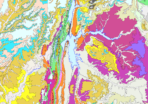
Lithostratigraphic map of Spain at a scale of 1:200.000 continuous digital.
The continuous lithostratigraphic map of Spain in digital format at a scale of 1:200,000 represents the cartographic units characterised mainly according to lithostratigraphic and hydrogeological criteria. The criteria maintained to consider their cartographic representation are to maintain those units that present an important lithostratigraphic development, both for their representation and their singularity, also incorporating those that show a high hydrogeological interest, either because of their lithological nature (high permeability) or because they are considered to form an essential part of the definition of the aquifer. The contacts between the cartographic units represented were normal, unconformable and intrusive contacts. Faults, thrusts and folding structures are represented.
Thus, a continuous map has been obtained in digital format, in which there are still areas with a higher density of cartographic information than others, either because they come from synthesis maps made with less general criteria than these, or because for their preparation, smaller scale cartographies (e.g. 1:50,000) have been used, thus obtaining a much richer and more detailed cartography.
This map is the basis of the permeability and hydrogeological maps of Spain at a scale of 1:200,000 continuous and in digital format.
This cartography is adapted to the hydrographic network and the shadow model made by CEDEX, at a scale of 1:200,000, from the topographic base, at a scale of 1:50,000, of the Army Cartographic Service. The cartographic information is referenced to coordinates in UTM projection, European Datum, zone 30, except for that corresponding to the Canary Islands, which is referenced to zone 28.
The map is made up of the following information layers: Cartographic Units (LPLIT), Contacts and Fractures (LPCYF) and Folding Structures (LPEST).
The format of the information generated is Shape file.
Simple
- Alternate title
-
Lithostratigraphic 200 continuous digital
- Date (Creation)
- 2005-09-18
- Date (Publication)
- 2007-09-30
- Date (Revision)
- 2009-08-05
- Edition
-
2ª edición
- Edition date
- 2009-01-01
- Citation identifier
- 637841
- Presentation form
- Hardcopy document
- Presentation form
- Hardcopy map
- Presentation form
- Digital document
- Presentation form
- Digital map
- Purpose
-
Hydrogeological information and maps are needed to define and delimit groundwater bodies with greater precision, so that this information can be used to: indicate the location and limits of groundwater bodies, define the general characteristics of the overlying strata of the catchment area, sources of contamination, etc. And to carry out the additional characterisation of the m.a.s. at risk, where it is necessary to establish their recharge areas, the characteristics of the chemical composition of the water, the location of the groundwater extraction points, the protected areas and their characteristics.
As a preliminary work, the continuous lithostratigraphic map of Spain was produced in digital format, a fundamental starting point for the preparation of the permeability and hydrogeological maps of Spain at a scale of 1:200,000, continuous and in digital format.
All of them were prepared by means of a "Collaboration Agreement between the Ministry of the Environment (General Secretariat for Territory and Biodiversity. Directorate General for Water) and the Geological Survey of Spain for the execution of technical works in relation to the application of the Water Framework Directive on groundwater'' signed in 2004.
- Credit
-
Director, project coordinator: Miguel del Pozo Gómez ( IGME )
Supervisors:
IGME technical-scientific staff.
Contributors:
REMAIN technical-scientific staff ( zone 1).
Technical-scientific staff of TECNA (zone 2 )
Technical-scientific staff of CGS (zone 3 )
Technical-scientific staff of EPTISA (zone 4 )
Technical-scientific staff of AURENSIS (area 5 )
Technical-scientific staff of INYPSA (zone 6 )
Technical-scientific staff of INTECSA (zone 7 )
Technical-scientific staff of INIMA (zone 8)
Technical-scientific staff of IDRENA (zone 9)
Technical-scientific staff of BIOSFERA XXI (zone 10).
Carried out by means of a collaboration agreement between the Directorate General for Water, MIMAM and IGME.
- Status
- Completed
- Point of contact
-
Organisation name Individual name Electronic mail address Role Geological Survey of Spain (IGME-CSIC)
Mejías Moreno, Miguel
Point of contact
- Maintenance and update frequency
- Not planned
-
IGME Thesaurus
-
-
General geology.geology
-
Stratigraphy.lithostratigraphy
-
Hydrology, Hydrogeology, Hydrogeology. hydrogeology
-
Sedimentología y Petrología sedimentaria.mapa litológico
-
Stratigraphy.stratigraphic map
-
General geology.rock
-
General geology.rock.crystalline rock.igneous rock
-
General geology.rock.sedimentary rock
-
Systematics of igneous rocks.plutonic rock
-
-
CEOLocation
-
-
COUNTRIES.SPAIN
-
- Keywords
-
-
Chronostratigraphy
-
- Keywords
-
-
Permeability
-
- Keywords
-
-
Groundwater
-
- Keywords
-
-
DMA
-
- Keywords
-
-
Groundwater body
-
-
GEMET
-
-
NATURAL ENVIRONMENT, ANTHROPIC ENVIRONMENT
-
HYDROSPHERE (freshwater, seawater, waters)
-
hydrosphere
-
water (geography)
-
groundwater
-
- Keywords
-
-
EGDI
-
- Specific usage
-
The Lithostratigraphic Map of Spain at a scale of 1:200,000 continuous digital is the starting point for the elaboration of the Permeability Map of Spain at a scale of 1:200,000 continuous digital and the Hydrogeological Map of Spain at a scale of 1:200,000 continuous digital. It aims to contribute to compliance with the Water Framework Directive.
- User contact info
-
Organisation name Individual name Electronic mail address Role Geological Survey of Spain (IGME-CSIC)
Point of contact
- Access constraints
- Other restrictions
- Other constraints
- No limitations on public access
- Use constraints
- Other restrictions
- Other constraints
-
LICENCE OF USE: Conditions of public use and dissemination of information for the re-use of IGME data. https://www.igme.es/condiciones-de-uso/
- Title
-
Hydrogeological Map of Spain at a scale of 1:200,000, continuous
- Date (Publication)
- 2009-08-05
- Cited responsible party
-
Organisation name Individual name Electronic mail address Role Geological Survey of Spain (IGME-CSIC)
Point of contact
- Aggregate Datasetindentifier
- 637843
- Association Type
- Cross reference
- Title
-
Permeability Map of Spain at a scale of 1:200.000, continuous
- Date (Publication)
- 2007-09-30
- Cited responsible party
-
Organisation name Individual name Electronic mail address Role Geological Survey of Spain (IGME-CSIC)
Point of contact
- Aggregate Datasetindentifier
- 637842
- Association Type
- Cross reference
- Spatial representation type
- Vector
- Denominator
- 200000
- Language
- Spanish; Castilian
- Character set
- 8859 Part 1
- Topic category
-
- Geoscientific information
))
- Supplemental Information
-
The document "Preparation of the hydrogeological map of Spain at a scale of 1:200,000, continuous and in digital format" (2009) can be consulted in the Documentation Service, where the process of preparation and description of the information prepared is described in detail.
There is an application for distribution on DVD, published in 2007, which contains the geological and cartographic information, tables, symbology libraries and map compositions. It has a consultation application and a map viewer.
The lithostratigraphic map of Spain at a scale of 1:200,000 can be viewed and consulted in the Groundwater Information System (SIAS), of the Geological Survey of Spain (IGME); and in the Integrated Water Information System (SIA), of the Ministry of the Environment, Rural and Marine Affairs (MARM), lithology layer.
- Unique resource identifier
- EPSG:6230
- Unique resource identifier
- EPSG:23028
- Unique resource identifier
- EPSG:23030
- Unique resource identifier
- EPSG:4258
- Distribution format
-
Name Version Mapa digital: JPEG -Joint Photographic Group Format
Unknown
Mapa digital: SHP - ArcView ShapeFile
8.3.0.800
Mapa digital: PDF - Portable Document Format
Unknown
Mapa en papel
Unknown
Servicio web: WMS - Web Map Service
Unknown
Distributor
- Distributor contact
-
Organisation name Individual name Electronic mail address Role Geological Survey of spain (IGME-CSIC)
Distributor
- Distributor format
-
Name Version Mapa digital: JPEG -Joint Photographic Group Format
-
Mapa digital: SHP - ArcView ShapeFile
8.3.0.800
Mapa digital: PDF - Portable Document Format
-
Distributor
- Distributor contact
-
Organisation name Individual name Electronic mail address Role Centro de Documentación del Instituto Geológico y Minero de España (IGME-CSIC)
Distributor
- Distributor format
-
Name Version Mapa en papel
-
Distributor
- Distributor contact
-
Organisation name Individual name Electronic mail address Role Vicedirección Técnica de Sistemas de Información Geológica del Instituto Geológico y Minero del España (IGME-CSIC)
Distributor
- Distributor format
-
Name Version Servicio web: WMS - Web Map Service
1.3.0
- Units of distribution
-
Unidades cartográficas (LPLIT): Recintos poligonales litológicos con las unidades cartográficas codificadas según el campo FH. Cada recinto o polígonos tiene un códigos numérico correspondiente a la formación geológica según la columna litoestratigráfica (FH). La descripción litológica completa, la descripción geocronológica y la clasificación de permeabilidad se almacenan en una tabla externa (Tabla litperm.dat) que tiene un registro por cada formación litoestratigráfica en el mapa. Para favorecer la utilización y correcta simbolización de la información generada, se crea otra tabla externa (Tabla colores.lut) que relaciona cada una de las formaciones con el color que se le debe asignar al realizar la composición de la leyenda y mapa litoestratigráfico. Contactos y fracturas (LPCYF): Líneas que delimitan recintos poligonales litológicos (contactos) y fallas o líneas de fractura con o sin cambio de identificación litológica. Todos los elementos lineales de esta capa llevarán asociado su código en un campo denominado ID según la librería de símbolos MAGNA. Estructuras de plegamiento (LPEST): Líneas que representan la traza axial de los pliegues. Todos los elementos lineales de esta capa llevarán asociado su código en un campo denominado ID según la librería de símbolos MAGNA.
- OnLine resource
-
Protocol Linkage Name OGC:WMS-1.3.0-http-get-capabilities
http://mapas.igme.es/gis/services/Cartografia_Tematica/IGME_Litoestratigrafico_200/MapServer/WMSServer?Request=GetCapabilities&Service=WMS Link to the GetCapabilities of the web service hosting the product
WWW:LINK-1.0-http--related
http://mapas.igme.es/Servicios/default.aspx#IGME_Litoestratigrafico200 Link to the product page on the IGME web site
- Name
- DVD
- Hierarchy level
- Dataset
Completeness commission
- Name of measure
-
Duplicate phenomena
- Measure description
-
Geometric and topological control using GIS application tools.
Conformance result
- Title
-
Geometric and topological control using the tools of the GIS application.
- Date (Revision)
- 2007-09-30
Citation identifier
- Explanation
-
Digital comparative validation and visual comparative check of the original map and the digitised map. Validation with error rate < 1%.
- Pass
- Yes
Completeness omission
- Name of measure
-
Duplicate phenomena
- Measure description
-
Duplicate phenomena
Conformance result
- Title
-
Duplicate phenomena
- Date (Revision)
- 2007-09-30
Citation identifier
- Explanation
-
Duplicate phenomena
- Pass
- Yes
Conceptual consistency
- Name of measure
-
Degree of approximation of the digital data with the conceptual model. Distribution of phenomena in classes.
- Measure description
-
Manual verification
Conformance result
- Title
-
Hydrogeological mapping data model at a scale of 1:200,000 in digital format.
- Date (Revision)
- 2007-09-30
Citation identifier
- Explanation
-
Check that the digital information is consistent with the standards that conceptually define it. Consult the standard
- Pass
- Yes
Format consistency
- Name of measure
-
Degree of approximation of the data to the established physical structure.
- Measure description
-
Automatic verification
Conformance result
- Title
-
Specifications for the digitisation of hydrogeological mapping
- Date (Revision)
- 2007-09-30
Citation identifier
- Explanation
-
Check that the digital information is in accordance with the standards. Consult the standard
- Pass
- Yes
Non quantitative attribute accuracy
- Name of measure
-
Absence of errors in the assignment of values.
- Measure description
-
Comparative study with source information
Conformance result
- Title
-
Comparative study with source information
- Date (Revision)
- 2007-09-30
Citation identifier
- Explanation
-
Digital comparative validation and comparative visual check of the original map and the digitised map. Error rate < 1%.
- Pass
- Yes
Conformance result
Conformance result
Conformance result
- Date (Publication)
- 2010-12-08
Citation identifier
- Explanation
-
Consult the regulations
- Pass
- No
- Statement
-
The preparation of the lithostratigraphic map involved a series of stages:
1.-Zoning of the Spanish territory according to fundamentally geological and hydrogeological criteria and adapting them to the limits of the topographic sheets at a scale of 1:200,000 established by the IGN.
2.- Compilation of information for each of the zones.
3.- Elaboration of a synthetic chronostratigraphic legend for each of the zones.
4.- Creation of each of the zonal cartographies based on the zonal legends.
5.- Conformation of zones (cases), with the cartographic case of the zones in order to obtain a map without discontinuities.
Elaboration of the lithostratigraphic legend, through the unification and synthesis of all the cartographic terms represented in the zonal legends. Carried out according to chronostratigraphic criteria established in the different geological domains defined for each period in the Spanish territory.
7.- Lithostratigraphic map, made from the lithostratigraphic legend taking into account the scale 1:200,000.
- Description
-
Zoning:
The Spanish territory was divided into 10 zones according to fundamentally geological and hydrogeological criteria. The limits of these zones were established taking into account, in addition to the aforementioned geological criteria, the limits of the topographic sheets at a scale of 1:200,000 established by the IGN to which these zones have been adapted. This distribution allows their subsequent treatment at a scale of 1:200,000, facilitating their representation and working approach.
The work zones established in this study are as follows:
Zone 1. Northern Iberian Massif; Zone 2. North; Zone 3. Ebro-Catalonia; Zone 4. Duero; Zone 5. Southern Iberian Massif; Zone 6. Tagus-Mancha; Zone 7. Levante-Ibérica; Zone 8. Guadalquivir; Zone 9. Balearic Islands; Zone 10.
- Description
-
Compilation of information:
For each of these areas, a compilation and analysis of the cartographic information available at that time was carried out under the following premises: a) That it was in digital format, b) That it came from previous syntheses at a scale of 1:200,000 or, failing that, as close to this scale as possible, and
c) When the previous premises were not met, recourse was had to 1:50,000 (MAGNA) in digital format or other cartographies.
- Description
-
Zonal legend:
For each of the working zones, a synthetic chronostratigraphic legend was prepared for all the cartographic units represented in the zones.
In these legends, an attempt was made to maintain those cartographic units that present an important lithostratigraphic development in each zone, both due to their cartographic representation and their singularity, also incorporating those that show a high hydrogeological interest, either due to their lithological nature (high permeability) or because they are considered to form an essential part of the definition of the aquifer.
- Description
-
Zonal cartography:
For each of the ten zones the cartography was carried out, maintaining the same criteria as those already indicated for the production of the legend, that is to say, maintaining the representation of the cartographic units that present a singularity of lithostratigraphic and hydrogeological character, taking into account that the established working scale is 1:200,000.
The contacts between the cartographic units were arranged according to the regulations established for this cartography. Normal, unconformable and intrusive contacts were represented, as well as faults, thrusts and folding structures.
- Description
-
Conformation of zones:
Once the synthesis of each of the zones had been completed, and due to the diverse origin of the starting cartography, it was necessary to cartographically marry these together to obtain a map without discontinuities between the limits of the different zones.
- Description
-
Lithostratigraphic legend:
Subsequently, the unification and synthesis of all the cartographic terms represented in the zonal legends was carried out. This legend was made according to chronostratigraphic criteria established in the different geological domains that have been defined for each period in the Spanish territory.
- Description
-
Lithostratigraphic Map:
Once the lithostratigraphic legend was completed, the lithostratigraphic map of the Spanish territory was drawn up, taking into account that the scale of this cartography is 1,200,000. In this cartography, the main aim has been to unify the minimum dimensions of outcrops, eliminating those that do not have a cartographic extension that allows their visualisation and integration within the geological set. Likewise, an attempt has been made to unify the criteria for the representation of structural elements, making it possible to differentiate the main structures affecting a geological domain, their distribution and density of structural affection.
- Description
-
computer processing:
Integration of all information in a Geographic Information System, establishing criteria on the characteristics of the data and its scope.
- Description
-
The rock units of the sheet separated by different types of contacts are represented, together with the tectonic structure, faults and map traces of folds, the orientation and dip of planar and linear elements contained in the rocks, structural and textural singularities of igneous and metamorphic rocks, water points, mineral deposits and indications, presence of fossils and other elements of punctual representation.
- Denominator
- 200000
- Title
-
Geological Map of Spain series at scale 1:200.000
- Date (Creation)
- 1981-01-01
- Cited responsible party
-
Organisation name Individual name Electronic mail address Role Geological Survey of Spain (IGME-CSIC)
Distributor
- Presentation form
- Digital document
- Presentation form
- Digital table
- Description
-
The rock units of the sheet separated by different types of contacts are represented, together with the tectonic structure, faults and map traces of folds, the orientation and dip of planar and linear elements contained in the rocks, structural and textural singularities of igneous and metamorphic rocks, water points, mineral deposits and indications, presence of fossils and other elements of punctual representation.
- Denominator
- 50000
- Title
-
Geological Map of Spain at a scale of 1:50.000, MAGNA
- Date (Creation)
- 1971-01-01
- Cited responsible party
-
Organisation name Individual name Electronic mail address Role Geological Survey of Spain (IGME-CSIC)
Distributor
- Description
-
Map with the chronolithostratigraphic units differentiated according to their hydrogeological characteristics divided into impermeable and permeable units distinguished by colours and plots.
- Denominator
- 200000
- Title
-
Hydrogeological Map of Spain at scale 1:200.000
- Date (Creation)
- 1982-01-01
- Cited responsible party
-
Organisation name Individual name Electronic mail address Role Geological Survey of Spain (IGME-CSIC)
Distributor
- Presentation form
- Digital document
- Presentation form
- Digital table
Metadata
- File identifier
- ESPIGMELITOESTRATIGRAFICO200CONTINUODIGITAL20100804637841 XML
- Metadata language
- Spanish; Castilian
- Character set
- 8859 Part 1
- Hierarchy level
- Dataset
- Date stamp
- 2026-02-23T16:27:18.358156Z
- Metadata standard name
-
Reglamento (CE) Nº 1205/2008 de Inspire, "Perfil IGME"
- Metadata standard version
-
2.0
- Metadata author
-
Organisation name Individual name Electronic mail address Role Geological Survey of Spain (IGME-CSIC)
Leticia Vega Martín
Point of contact
- Other language
-
Language Character encoding English UTF8 Spanish; Castilian UTF8
)))